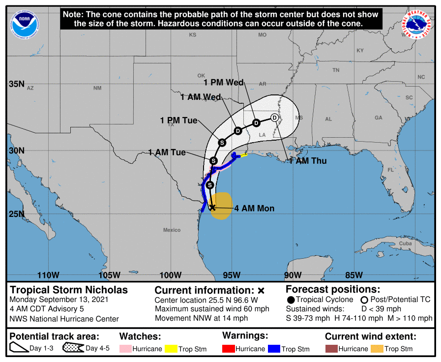
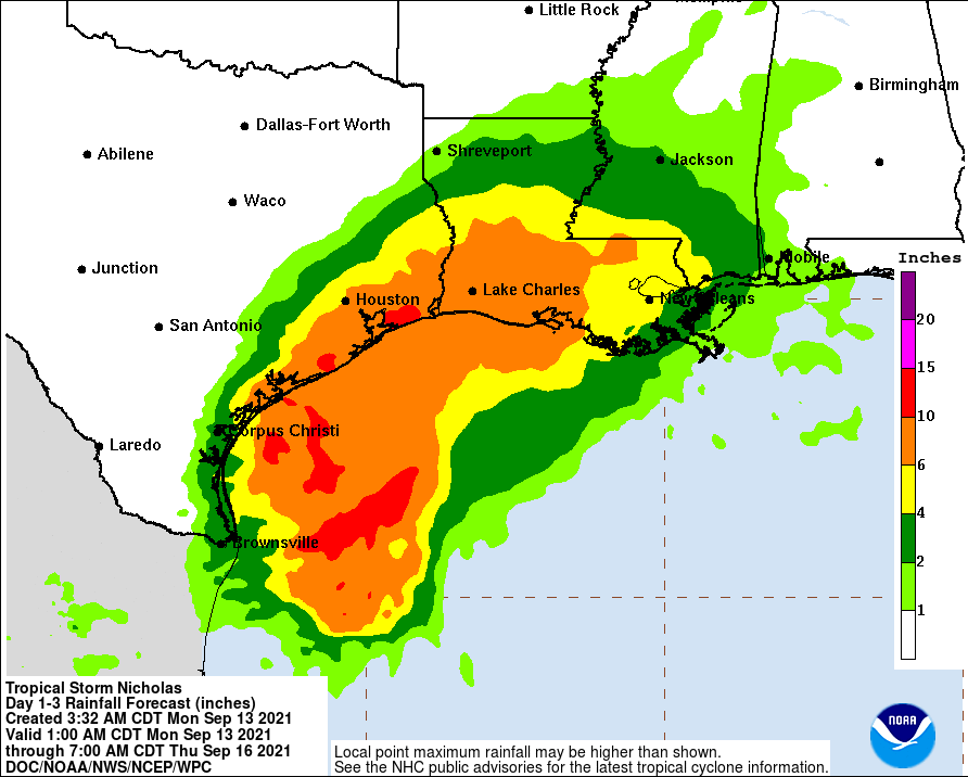
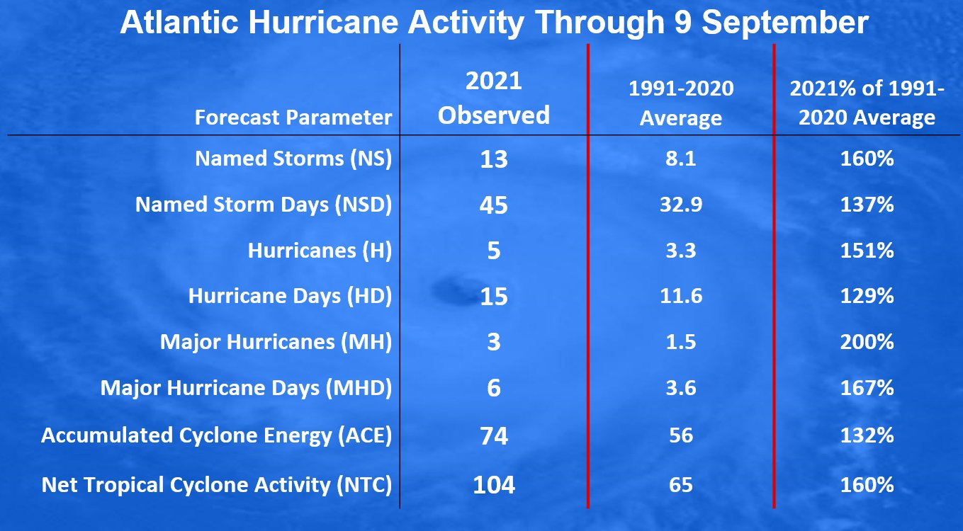
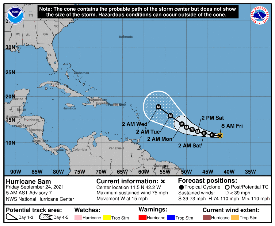
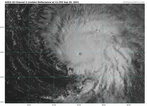
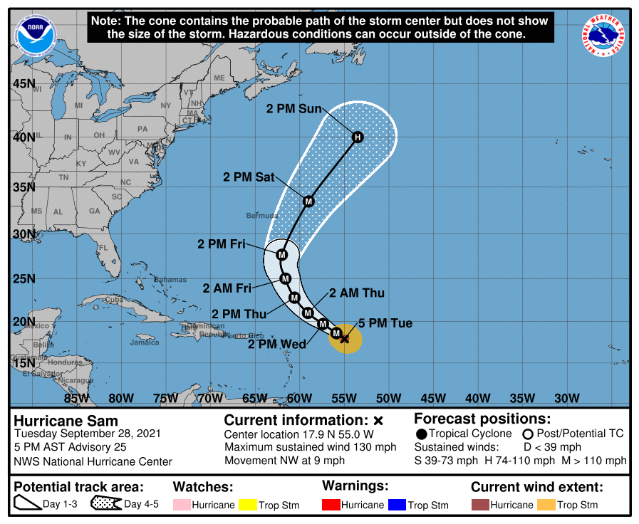
No idea what happened to the thread I posted on this back in June when all the seasonal forecasts came out, but fortunately (for maybe a few of you, lol), I post this stuff in multiple places, so below is what I posted back in early June; the subsequent posts on a bunch of tropical systems prior to Henri are gone, though. Obviously, we already have 13 named storms this season and we're only at the midway point of typical seasonal activity (Sept 10th), so odds are pretty high this season will be well above normal, unfortunately.
Post from June 4th 2021:
After last year's record smashing tropical season, featuring 30 named storms, 14 hurricanes and 7 major (cat 3 or higher) hurricanes, we could use a break this season, but today CSU (home of the late, great Dr. Gray, who pioneered seasonal tropical forecasting for the Atlantic Basin nearly 40 years ago) joined NOAA in predicting a moderately above average tropical season in the Atlantic this year. See the graphic below from the forecast issued today by CSU.
https://tropical.colostate.edu/Forecast/2021-06.pdf
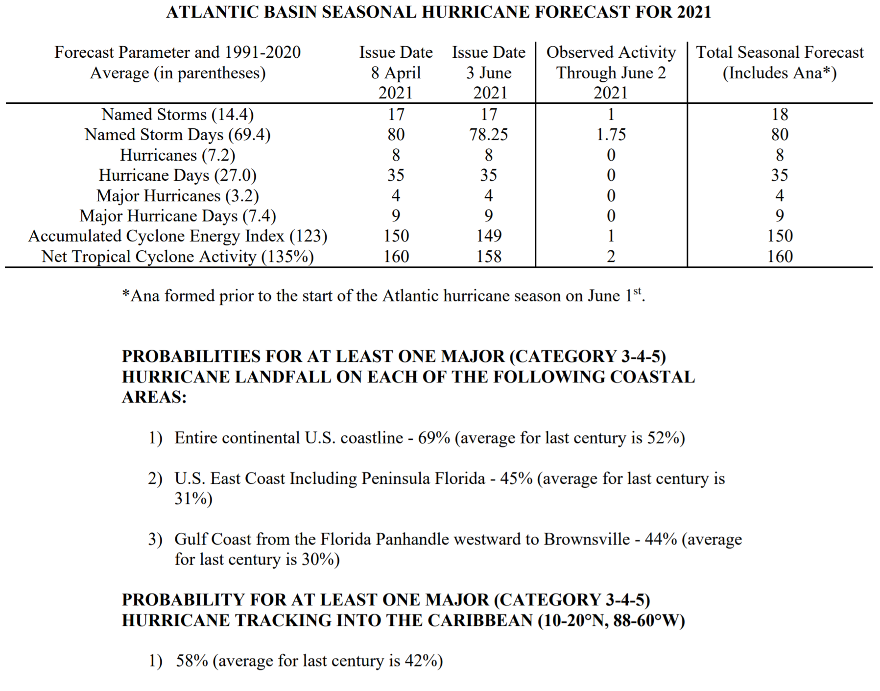
Their prediction is for 18 named storms (14.4 avg), 8 hurricanes (7.2 avg) and 4 major hurricanes (3.2 avg), which doesn't sound that far above average until one realizes that they're comparing against the 30-year period from 1991-2020, which was a bit busier than the 1981-2010 period they've been comparing against for the last 10 years, where the seasonal average was 12.1 named storms, 6.4 hurricanes and 2.7 major hurricanes.
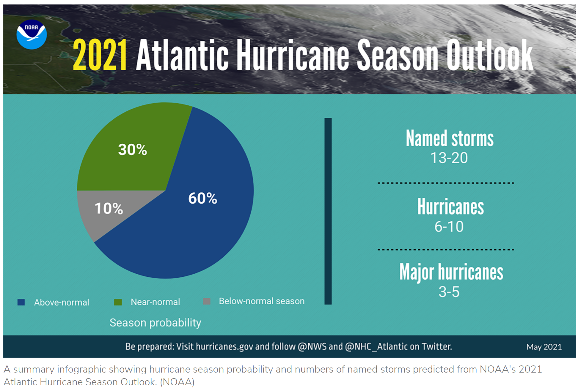
NOAA issued their forecast 2 weeks ago and it's fairly similar with somewhat above average numbers being predicted of 13-20 named storms 6-10 hurricanes and 3-5 major hurricanes; see graphic below. They do ranges, unlike CSU, but the midpoint of their ranges is very close to CSU's prediction, i.e., 16.5 named storms (18 from CSU), 8 hurricanes (8 from CS) and 4 major hurricanes (4 from CSU).
https://www.noaa.gov/.../noaa-predicts-another-active...
Both groups use much of the same combination of analog-based forecasts (looking back at key tropical indicators, like El Nino and tropical Atlantic sea surface temps for past seasons with similar indicators) and forward-looking dynamical/statistical global weather models and both cite the neutral ENSO (El Nino/Southern Oscillation indicator) state, where El Nino conditions inhibit tropical activity and current warmer-than-normal subtropical Atlantic SSTs as keys to their forecasts.
We'll see soon, but keep in mind that the CSU group has been far more accurate (near 70%) with their above normal, normal, below normal predictions than simple climatological guessing would be (1 in 3, on average, if guessing). We've had one minor tropical storm so far this season (Ana).
Post from June 4th 2021:
After last year's record smashing tropical season, featuring 30 named storms, 14 hurricanes and 7 major (cat 3 or higher) hurricanes, we could use a break this season, but today CSU (home of the late, great Dr. Gray, who pioneered seasonal tropical forecasting for the Atlantic Basin nearly 40 years ago) joined NOAA in predicting a moderately above average tropical season in the Atlantic this year. See the graphic below from the forecast issued today by CSU.
https://tropical.colostate.edu/Forecast/2021-06.pdf
Their prediction is for 18 named storms (14.4 avg), 8 hurricanes (7.2 avg) and 4 major hurricanes (3.2 avg), which doesn't sound that far above average until one realizes that they're comparing against the 30-year period from 1991-2020, which was a bit busier than the 1981-2010 period they've been comparing against for the last 10 years, where the seasonal average was 12.1 named storms, 6.4 hurricanes and 2.7 major hurricanes.
NOAA issued their forecast 2 weeks ago and it's fairly similar with somewhat above average numbers being predicted of 13-20 named storms 6-10 hurricanes and 3-5 major hurricanes; see graphic below. They do ranges, unlike CSU, but the midpoint of their ranges is very close to CSU's prediction, i.e., 16.5 named storms (18 from CSU), 8 hurricanes (8 from CS) and 4 major hurricanes (4 from CSU).
https://www.noaa.gov/.../noaa-predicts-another-active...
Both groups use much of the same combination of analog-based forecasts (looking back at key tropical indicators, like El Nino and tropical Atlantic sea surface temps for past seasons with similar indicators) and forward-looking dynamical/statistical global weather models and both cite the neutral ENSO (El Nino/Southern Oscillation indicator) state, where El Nino conditions inhibit tropical activity and current warmer-than-normal subtropical Atlantic SSTs as keys to their forecasts.
We'll see soon, but keep in mind that the CSU group has been far more accurate (near 70%) with their above normal, normal, below normal predictions than simple climatological guessing would be (1 in 3, on average, if guessing). We've had one minor tropical storm so far this season (Ana).