@Tango Two @Richard Schnyderite - would request this thread not be combined with Tango's thread on Sunday's event. I was going to also include Sunday's event in this thread, but just noticed that one was started, so I'll comment in that thread and leave this to the pattern discussion. Thanks.
The Pattern We're In Now and for the Next Few Weeks
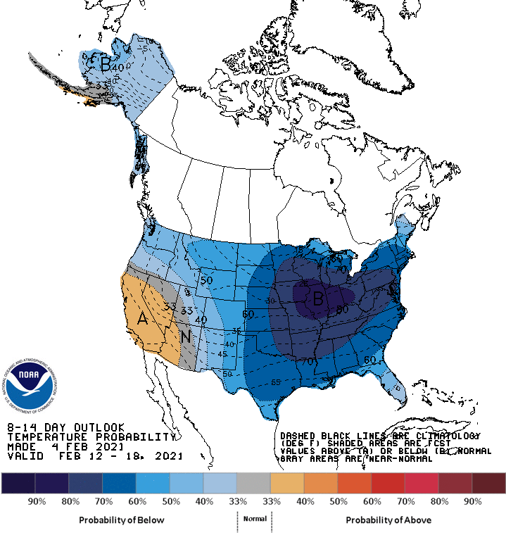
So, thought it was time for a winter pattern thread for the next ~2 weeks or so. Right now it's looking quite likely that the next 2 weeks will continue to be colder than normal, with it likely being much colder than normal starting early next week through next weekend and maybe beyond (and some brutal cold is possible next week; see the CPC graphic below). Cold doesn't necessarily mean snowy, though, but the long range models also show that the pattern will also be active, especially the subtropical jet stream which often brings storms across the US. With "blocking" likely remaining in place for the next few weeks, cold air will remain and storms will have a hard time cutting to our west bringing rain. The 33andrain "pattern" thread is below.
https://www.33andrain.com/topic/1959-met-winter-20-21-pattern-drivers-evolution/page/210/
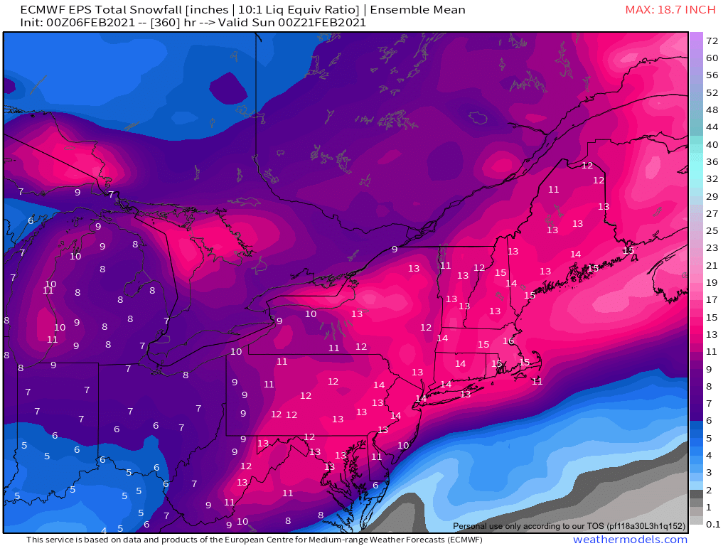
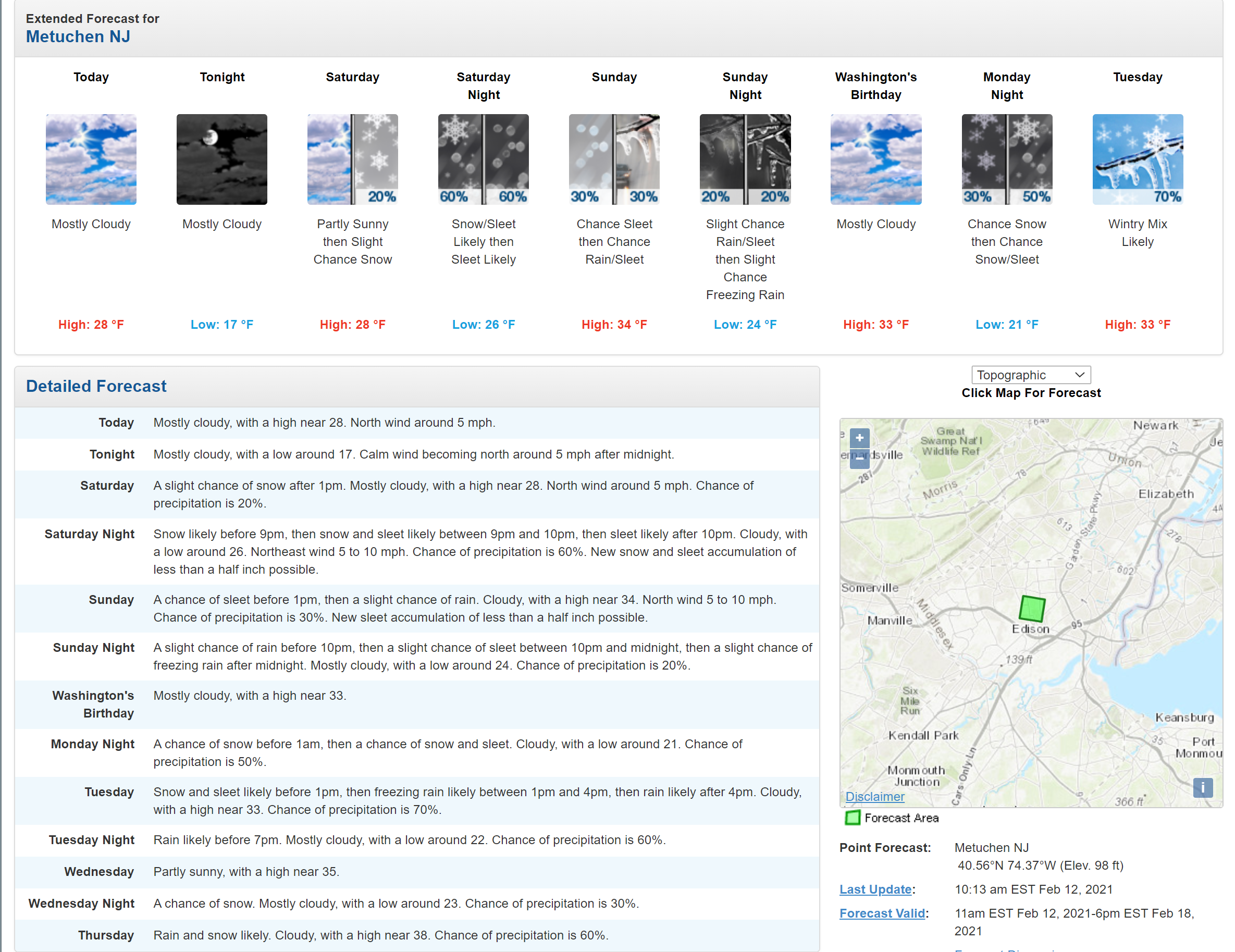
This doesn't guarantee we'll get snow, as sometimes these patterns result in suppression, driving snowfall chances down to the mid-Atlantic or even further south, but it certainly creates a situation where snowstorms are more likely than they are in most other winter patterns around here. A perfect case in point could be Sunday's possible storm, which I've been posting about in the storm thread from this week. It looked threatening a few days ago, then looked like it was going to be suppressed and is now looking somewhat threatening again, with most models showing at least a few inches of snow for the Philly-NJ-NYC corridor and some showing more than that (and a couple showing some or complete suppression still) - since we're within 84 hours of this sytem, we have more models to look at.
And beyond Sunday, there are 2-3 more threats showing up from early next week through about 2/18 or so. It's possible none of these give us snow or we get a bit of snow from a few or we get hammered by one or two, but as I said, it's more likely we get snow during the next 2 weeks or so than it would be in most other patterns we see, just like it was more likely to get snow for the 2nd half of January than it would have normally been. Will just have to wait and see. The 33andrain winter threats thread link is below as is the thread to Sunday's event.
https://www.33andrain.com/topic/2010-weather-threats-winter-2020-21-edition-part-ii/page/360/
https://www.33andrain.com/topic/201...nowstorm/page/24/?tab=comments#comment-269931
I also included a discussion on what many of these same folks were saying back in mid-January about the pattern we have now evolving back then. My point in sharing below what was discussed a few weeks ago is to illustrate that there is some moderate accuracy in pattern predictions for 2-3 weeks out, at least with regard to colder/warmer than normal and snowier/less snowier than normal. I don't have much confidence in seasonal forecasts made back in the fall, as very few have demonstrated skill in doing that - and most who did that this year were predicting very low snowfalls for our area due to La Nina, so obviously, most have already gotten their seasonal snow forecasts wrong.
What the Future Pattern Looked Like Back on about 1/15:
I've done pattern threads before and thought about doing one around 1/15 or so, when many of the pattern experts on the weather boards could see the pattern evolving into a cold and potentially snowy pattern, for the last part of January, but didn't get around to it and then just focused on the 1/31-2/2 storm starting around 1/23 or so. I'm not going to go into all the details, as I just don't have time, but the link below to a page on 33andrain's patterns thread on 1/15 clearly shows a lot of discussion about that pattern with high latitude "blocking" (-AO/-NAO), which often locks relatively cold air in place over the Great Lakes and NE.
https://www.33andrain.com/topic/1959-met-winter-20-21-pattern-drivers-evolution/page/195/
This blocking often forces shortwaves (low pressure systems) to move underneath that blocking to our west sometimes leading to snows across the midwest into the Ohio Valley, which can reach us directly or sometimes lead to coastal lows that bring snows up the coast, like we just saw, with our Miller B, which featured both the approaching storm from the west and the transfer of that energy to a coastal low that formed off NC and rode up the coast, rather than cutting inland bringing us rain (which happened a ton the last two winters with very little blocking).
Several of these folks were talking about enhanced snowfall for the last 2 weeks in Jan into early February. Obviously, the system on 1/25-26 ended up being a good snowmaker to our west, but it just fizzled as it got here, but clearly, the storm this week more than made up for that from a snowfall perspective, as now most of this region is now well above normal for snowfall so far this winter and much of EPA, CNJ, NNJ, SENY/NYC/LI, CT are near or above normal snowfall for the entire winter and we have a good 6 weeks left for more snow - whereas DC/Balt are below normal and Providence, Boston, Portland are about normal (data below).
Seasonal snowfall amounts to date include (from donsutherland on the weather boards)
Albany: 46.4" (10.3" above normal)
Baltimore: 6.1" (5.1" below normal)
Binghamton: 77.4" (28.7" above normal)
Boston: 24.3" (0.1" below normal)
Bridgeport: 28.9" (14.6" above normal)
Caribou: 57.9" (4.9" below normal)
Harrisburg: 24.5" (8.8" above normal)
Islip: 19.5" (6.2" above normal)
New York City: 28.0" (14.9" above normal) - and already at/above the seasonal average
Newark: 31.1" (16.4" above normal) - - and already at/above the seasonal average
Philadelphia: 14.7" (3.4" above normal)
Portland: 34.5" (1.2" below normal)
Providence: 18.4" (1.8" below normal)
Washington, DC: 3.5" (5.6" below normal)
The Pattern We're In Now and for the Next Few Weeks
So, thought it was time for a winter pattern thread for the next ~2 weeks or so. Right now it's looking quite likely that the next 2 weeks will continue to be colder than normal, with it likely being much colder than normal starting early next week through next weekend and maybe beyond (and some brutal cold is possible next week; see the CPC graphic below). Cold doesn't necessarily mean snowy, though, but the long range models also show that the pattern will also be active, especially the subtropical jet stream which often brings storms across the US. With "blocking" likely remaining in place for the next few weeks, cold air will remain and storms will have a hard time cutting to our west bringing rain. The 33andrain "pattern" thread is below.
https://www.33andrain.com/topic/1959-met-winter-20-21-pattern-drivers-evolution/page/210/
This doesn't guarantee we'll get snow, as sometimes these patterns result in suppression, driving snowfall chances down to the mid-Atlantic or even further south, but it certainly creates a situation where snowstorms are more likely than they are in most other winter patterns around here. A perfect case in point could be Sunday's possible storm, which I've been posting about in the storm thread from this week. It looked threatening a few days ago, then looked like it was going to be suppressed and is now looking somewhat threatening again, with most models showing at least a few inches of snow for the Philly-NJ-NYC corridor and some showing more than that (and a couple showing some or complete suppression still) - since we're within 84 hours of this sytem, we have more models to look at.
And beyond Sunday, there are 2-3 more threats showing up from early next week through about 2/18 or so. It's possible none of these give us snow or we get a bit of snow from a few or we get hammered by one or two, but as I said, it's more likely we get snow during the next 2 weeks or so than it would be in most other patterns we see, just like it was more likely to get snow for the 2nd half of January than it would have normally been. Will just have to wait and see. The 33andrain winter threats thread link is below as is the thread to Sunday's event.
https://www.33andrain.com/topic/2010-weather-threats-winter-2020-21-edition-part-ii/page/360/
https://www.33andrain.com/topic/201...nowstorm/page/24/?tab=comments#comment-269931
I also included a discussion on what many of these same folks were saying back in mid-January about the pattern we have now evolving back then. My point in sharing below what was discussed a few weeks ago is to illustrate that there is some moderate accuracy in pattern predictions for 2-3 weeks out, at least with regard to colder/warmer than normal and snowier/less snowier than normal. I don't have much confidence in seasonal forecasts made back in the fall, as very few have demonstrated skill in doing that - and most who did that this year were predicting very low snowfalls for our area due to La Nina, so obviously, most have already gotten their seasonal snow forecasts wrong.
What the Future Pattern Looked Like Back on about 1/15:
I've done pattern threads before and thought about doing one around 1/15 or so, when many of the pattern experts on the weather boards could see the pattern evolving into a cold and potentially snowy pattern, for the last part of January, but didn't get around to it and then just focused on the 1/31-2/2 storm starting around 1/23 or so. I'm not going to go into all the details, as I just don't have time, but the link below to a page on 33andrain's patterns thread on 1/15 clearly shows a lot of discussion about that pattern with high latitude "blocking" (-AO/-NAO), which often locks relatively cold air in place over the Great Lakes and NE.
https://www.33andrain.com/topic/1959-met-winter-20-21-pattern-drivers-evolution/page/195/
This blocking often forces shortwaves (low pressure systems) to move underneath that blocking to our west sometimes leading to snows across the midwest into the Ohio Valley, which can reach us directly or sometimes lead to coastal lows that bring snows up the coast, like we just saw, with our Miller B, which featured both the approaching storm from the west and the transfer of that energy to a coastal low that formed off NC and rode up the coast, rather than cutting inland bringing us rain (which happened a ton the last two winters with very little blocking).
Several of these folks were talking about enhanced snowfall for the last 2 weeks in Jan into early February. Obviously, the system on 1/25-26 ended up being a good snowmaker to our west, but it just fizzled as it got here, but clearly, the storm this week more than made up for that from a snowfall perspective, as now most of this region is now well above normal for snowfall so far this winter and much of EPA, CNJ, NNJ, SENY/NYC/LI, CT are near or above normal snowfall for the entire winter and we have a good 6 weeks left for more snow - whereas DC/Balt are below normal and Providence, Boston, Portland are about normal (data below).
Seasonal snowfall amounts to date include (from donsutherland on the weather boards)
Albany: 46.4" (10.3" above normal)
Baltimore: 6.1" (5.1" below normal)
Binghamton: 77.4" (28.7" above normal)
Boston: 24.3" (0.1" below normal)
Bridgeport: 28.9" (14.6" above normal)
Caribou: 57.9" (4.9" below normal)
Harrisburg: 24.5" (8.8" above normal)
Islip: 19.5" (6.2" above normal)
New York City: 28.0" (14.9" above normal) - and already at/above the seasonal average
Newark: 31.1" (16.4" above normal) - - and already at/above the seasonal average
Philadelphia: 14.7" (3.4" above normal)
Portland: 34.5" (1.2" below normal)
Providence: 18.4" (1.8" below normal)
Washington, DC: 3.5" (5.6" below normal)
Last edited: