ADVERTISEMENT

OT: Dorian Likely to stay just offshore FL/GA/SC/NC as a Cat 3/4 Cane; high impacts stiil probable

RU848789

Legend
Gold Member
Jul 27, 2001
60,505
39,085
113
Metuchen, NJ
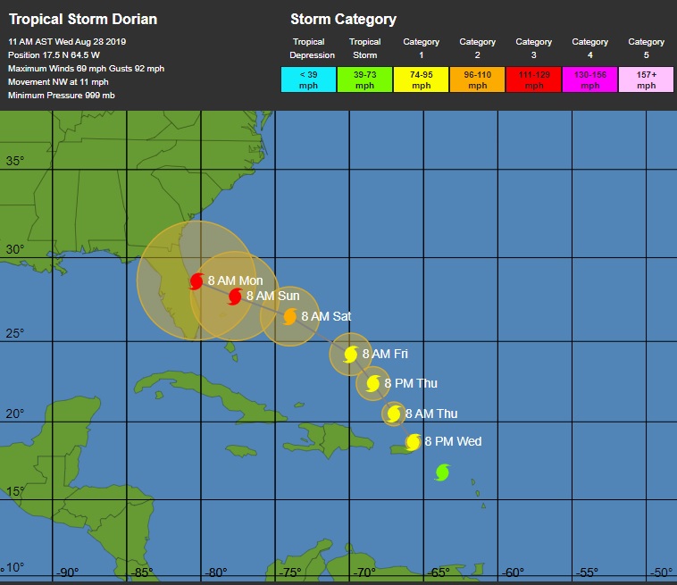
Been talking about this in the hurricane contest thread, but this threat is significant enough, IMO, to warrant its own thread. Over the last 24 hours, the storm has strengthened a bit more than expected and the track is now looking more likely to allow it to run the gap between far SW Puerto Rico and far SE Dominican Republic (which is less mountainous than the rest of Hispaniola), as a strong tropical storm/weak hurricane, which would bring flooding rains and some wind/storm surge impacts (nowhere near what a major hurricane would bring, but still worth watching). This track could allow Dorian to emerge into the far SE Bahamas without being shredded by interaction with those mountains.

If that occurs and the storm is still able to fight off the mid-level dry air that it has been and will continue fighting, it could still be a strong tropical storm in the Bahamas in a region of light wind shear and very high oceanic heat content (that's the official forecast at 5 days, which is as far out as the NHC goes with tropical forecasts, as uncertainty is too high beyond that), which means it could strengthen into a hurricane before taking aim at the east coast of Florida by Sunday/Monday, as some long range models are indicating.

While the track forecast for Dorian is challenging, the intensity forecast is nearly impossible. So many variables and intensity forecasts are far less accurate than track forecasts, as tiny track subtleties will have huge impacts on land/mountain interactions, shear is very complex to predict well and how well Dorian fights off the dry air are all key variables with large uncertainties, especially several days out. Intensity forecasts once the storm reaches the Bahamas and gets close to Florida range from it being a weak tropical storm to being a weak hurricane.

Bottom line is people in PR/DR need to be prepared and people in Florida and even up the coast to NC need to be watching this one closely over the next few days. Odds are still fairly low of a hurricane impacting FL/US, but much greater than they were yesterday...

https://www.wunderground.com/…/Now-Heading-Windward-Islands…

https://www.nhc.noaa.gov/r…/graphics_at5+shtml/023758.shtml…

69426025_10216874529369551_8214888877958103040_n.jpg
 
Only have a few minutes, but the latest forecast has Dorian as a strong tropical storm (~70 mph winds) making landfall in the West Palm to Vero Beach area early Sunday morning (the "cone" is much larger than that, though, so most of FL needs to pay attention). A ton of things have to happen for this to occur, as Dorian has many obstacles still, which could greatly weaken it or steer it elsewhere, but people in these areas do need to watch and start preparing, especially in case Dorian is stronger than forecast, as it will be going over warm waters with low shear...

69143422_10216876711704108_1457064618626121728_n.jpg


Looks like Dorian is getting excited!
 
  • Like
Reactions: T2Kplus10
Has anyone ever met an actual “Dorian”? sounds like the illicit love interest in a Latino telenovela...

I wonder what the name choosing process is like?
 
Only have a few minutes, but the latest forecast has Dorian as a strong tropical storm (~70 mph winds) making landfall in the West Palm to Vero Beach area early Sunday morning (the "cone" is much larger than that, though, so most of FL needs to pay attention). A ton of things have to happen for this to occur, as Dorian has many obstacles still, which could greatly weaken it or steer it elsewhere, but people in these areas do need to watch and start preparing, especially in case Dorian is stronger than forecast, as it will be going over warm waters with low shear...

69143422_10216876711704108_1457064618626121728_n.jpg

Not to hijack your thread, but is there any info on storms that may track through Jamaica fro Sept 4-15? Thank you
 
Not to hijack your thread, but is there any info on storms that may track through Jamaica fro Sept 4-15? Thank you

Sorry, but nearly impossible to predict that far out, which is why the NHC only discusses a 5-day horizon. Yes, there are models that might "predict" storm formation beyond Day 5, but those predictions are pretty inaccurate. All I can say now is that there are no obvious threats on the horizon through Sunday, 9/1. But if you look at the graphic below, we're clearly entering the peak period for tropical systems, historically speaking, with 9/5 to 9/15 being the sharp peak, so if you're going to be there keep a careful eye on things...

69040236_10216863619216804_6981188543276122112_n.jpg
 
  • Like
Reactions: huskersalways
Never had the makings of a varsity hurricane.

Most didn't think, as of Sunday, that Dorian would make it into the Bahamas, but that changed yesterday. Having said that, storm is looking a bit ragged now, so who knows. Absolute key is killing this thing over PR/Hispaniola, since if it holds together into the Bahamas, with light shear and very warm sea surface temps, it could strengthen quickly on its way towards Florida. A big if, though.
 
Hope my friend in Melbourne Beach is keeping an eye on this. Of course he's probably anticipating the waves.
 
Sorry, but nearly impossible to predict that far out, which is why the NHC only discusses a 5-day horizon. Yes, there are models that might "predict" storm formation beyond Day 5, but those predictions are pretty inaccurate. All I can say now is that there are no obvious threats on the horizon through Sunday, 9/1. But if you look at the graphic below, we're clearly entering the peak period for tropical systems, historically speaking, with 9/5 to 9/15 being the sharp peak, so if you're going to be there keep a careful eye on things...

69040236_10216863619216804_6981188543276122112_n.jpg

Thank you
 
SW Puerto Rico about to get hammered tomorrow late night by a strong TS Dorian and beyond that, the NHC discussion below is why people in Florida need to pay attention: assuming Dorian survives PR and misses the DR, as now forecast (track was adjusted about 60 miles NE due to reorganization of the storm's center today). Then Dorian will have a chance to strengthen from a weak TS to strong TS or even a cat 1 or 2 hurricane by likely landfall on the FL coast, as per a couple of the intensity models, since it will be traversing very warm waters, with light shear and less dry air impinging on the storm. Very high uncertainty on the intensity forecast...

https://www.nhc.noaa.gov/refresh/graphics_at5+shtml/023758.shtml?cone#contents

Dry air should continue to plague Dorian for the next 24 hours or
so, resulting in only slow strengthening. Land interaction with
Puerto Rico should significantly weaken the small cyclone, thus the
intensities were lowered at 36 and 48 hours. On days 3-5, the models
continue to indicate that the upper-level flow pattern and shear
conditions should favor strengthening, especially since Dorian will
be moving over SSTs greater than 29 deg C and into a moist mid-level
environment. The dynamical models such as the GFS, UKMET, and ECMWF
are now showing more strengthening than previous runs, but still
remain well below the statistical SHIPS and LGEM intensity models,
which bring Dorian to category 1 or 2 strength by day 5. The
official intensity forecast remains a compromise between the these
two extremes, and is close to the HCCA and FSSE consensus models.
Given the large spread in the guidance, there remains lower-than-
normal confidence in the intensity forecast, especially on days 4
and 5.

69560154_10216879756100216_1422583362748416000_n.jpg
Any thoughts about it cutting across central Florida to the gulf? Thanks.
 
Any thoughts about it cutting across central Florida to the gulf? Thanks.
Go to; tropicaltidbits.com
Click on forecast models
Click global
Click gfs
Click the play button
You’ll clearly see where the model takes it

The 18z gfs has it hitting Fl then Ga...this will likely change 5 times between now and then
 
  • Like
Reactions: RUaMoose
Any thoughts about it cutting across central Florida to the gulf? Thanks.

Tracks from most of the global/hurricane models. Not sure if this includes the Euro, though, which heads across central FL (with landfall near Melbourne) and into the NE GOM making a 2nd landfall near Pensacola. Hopefully it remains below hurricane strength. Can get this graphic and many others associated with Dorian at the same Tropical Tidbits site WPKnight mentioned. Just click on "Current Storms."

https://www.tropicaltidbits.com/storminfo/

69246692_10216880810126566_2001361477541298176_n.jpg
 
  • Like
Reactions: Rutgers8086
SW Puerto Rico about to get hammered tomorrow late night by a strong TS Dorian and beyond that, the NHC discussion below is why people in Florida need to pay attention: assuming Dorian survives PR and misses the DR, as now forecast (track was adjusted about 60 miles NE due to reorganization of the storm's center today). Then Dorian will have a chance to strengthen from a weak TS to strong TS or even a cat 1 or 2 hurricane by likely landfall on the FL coast, as per a couple of the intensity models, since it will be traversing very warm waters, with light shear and less dry air impinging on the storm. Very high uncertainty on the intensity forecast...

https://www.nhc.noaa.gov/refresh/graphics_at5+shtml/023758.shtml?cone#contents

Dry air should continue to plague Dorian for the next 24 hours or
so, resulting in only slow strengthening. Land interaction with
Puerto Rico should significantly weaken the small cyclone, thus the
intensities were lowered at 36 and 48 hours. On days 3-5, the models
continue to indicate that the upper-level flow pattern and shear
conditions should favor strengthening, especially since Dorian will
be moving over SSTs greater than 29 deg C and into a moist mid-level
environment. The dynamical models such as the GFS, UKMET, and ECMWF
are now showing more strengthening than previous runs, but still
remain well below the statistical SHIPS and LGEM intensity models,
which bring Dorian to category 1 or 2 strength by day 5. The
official intensity forecast remains a compromise between the these
two extremes, and is close to the HCCA and FSSE consensus models.
Given the large spread in the guidance, there remains lower-than-
normal confidence in the intensity forecast, especially on days 4
and 5.

69560154_10216879756100216_1422583362748416000_n.jpg

Dorian is going to hit Puerto Rico Wednesday evening as a strong tropical storm (60-70 mph winds) and then, assuming it survives, it is forecast to strengthen into a cat 1 hurricane by the time it makes landfall along the central/northern Florida coast on Sunday afternoon/evening.

The track forecast is likely fairly accurate, as they usually are (much easier to predict than intensity), as most models are showing a landfall in this area (with a few showing Dorian crossing into the GOM and then hitting the FL panhandle and a few showing it grazing FL and heading towards GA/SC/NC).

The biggest issue with Dorian for Florida is that intensity forecasts are often quite inaccurate and moreso when factoring in the uncertainty over the impact of traversing Puerto Rico. And if it remains reasonably intact after PR, it will be traversing very warm waters, with light shear and less dry air impinging on the storm from PR to Florida.

This means there is the potential for much more strengthening than is currently forecast - even a cat 3 hurricane is not out of the question, as per a couple of models. Of course, Dorian could also be torn apart by PR and never really recover, but this is looking unlikely now, as the time over land crossing PR from S to N is much shorter than it would've been if it had hit Hispaniola, as per yesterday's forecast.

As I said to my dad, who lives in Vero Beach, wait until after Dorian clears PR by sometime early Thursday and see what the forecast is then - there will still be plenty of time to evacuate, if needed at that point, with a landfall later on Sunday. Also, if the storm is just a minimal Cat 1 hurricane or strong TS, evacuation might not be needed.

Also, TS Erin finally formed off the Carolinas and is expected to move NE well off the US east coast and should not strengthen beyond about 45-50 mph.

https://www.nhc.noaa.gov/graphics_at1.shtml?start#contents

https://www.nhc.noaa.gov/refresh/graphics_at5+shtml/023758.shtml?cone#contents

https://www.wunderground.com/cat6/Dorian-Growing-More-Organized-it-Heads-Puerto-Rico

https://www.americanwx.com/bb/topic/52488-tropical-storm-dorian/?page=5

69018520_10216881808351521_1445657975761928192_n.jpg


69865531_10216881810391572_6721184151027843072_n.jpg
 
They don't make killer hurricanes anymore.
We're 2 weeks away from the 100th Anniversary of the Florida Keys hurricane of 1919 that killed 745.
 
The mountains in PR are not nearly as high as the DR (10k feet vs 4.3k feet)...and then that water NW of the island is fueled up (29-31C)

Here’s hoping it swings north and east before it reaches the coast.
 
When does it affect NJ?
Neither the main US or Euro models (as of 6z) have it affect NJ.

GFS model has it hit the GA SC NC coasts and then NE and the last Euro I saw N FL and then a bit into the gulf.

This is where that legion of tropical met phds down at coral gables earn their pay...
 
Busy at work, so just a few seconds to post that NHC forecast has been updated and Dorian now forecast to be a major cat 3 hurricane at landfall in central Florida, near Cape Canaveral (center of cone, but anywhere from about West Palm Beach to Jacksonville needs to be on alert still) with winds around 115 mph. As feared models are responding to the fact that the conditions are ripe for strengthening after crossing PR (low shear, very high ocean temps, less dry air).

FORECAST POSITIONS AND MAX WINDS

INIT 28/1500Z 17.5N 64.5W 60 KT 70 MPH
12H 29/0000Z 18.7N 65.7W 65 KT 75 MPH
24H 29/1200Z 20.5N 67.0W 65 KT 75 MPH
36H 30/0000Z 22.4N 68.4W 70 KT 80 MPH
48H 30/1200Z 24.2N 69.9W 75 KT 85 MPH
72H 31/1200Z 26.5N 74.0W 90 KT 105 MPH
96H 01/1200Z 27.7N 77.7W 100 KT 115 MPH
120H 02/1200Z 28.6N 80.3W 100 KT 115 MPH

https://www.nhc.noaa.gov/r…/graphics_at5+shtml/114938.shtml…

69077098_10216884326214466_3450129589446115328_n.jpg
 
Dorian now a hurricane with 75 mph winds and it's now looking like it won't even hit Puerto Rico, but will likely go just east of the island; right now it's essentially over St. Thomas in the Virgin Islands. Pretty significant track shift over the last 2-3 days vs. even the 24-36 hour forecasts, with part of that being the storm was so small and disorganized.

https://www.nhc.noaa.gov/refresh/graphics_at5+shtml/114938.shtml?cone#contents

But the link says there is a hurricane watch and tropical storm warning for Puerto Rico, so it's not out of the woods yet.
 
Dorian now a hurricane with 75 mph winds and it's now looking like it won't even hit Puerto Rico, but will likely go just east of the island; right now it's essentially over St. Thomas in the Virgin Islands. Pretty significant track shift over the last 2-3 days vs. even the 24-36 hour forecasts, with part of that being the storm was so small and disorganized.

https://www.nhc.noaa.gov/refresh/graphics_at5+shtml/114938.shtml?cone#contents

I sure hope so. Hopefully just rain for PR.
 
5 pm NHC advisory is up and Dorian still forecast to be a Cat 3 hurricane with 115 mph winds at landfall around Melbourne very early Monday morning (landfall moved south a bit since 11 am), but landfall could really be anywhere inside the cone and especially anywhere from West Palm Beach to Daytona.

Edit - also posted the spaghetti maps of all the major global/hurricane models. Northern Gulf coast really needs to be watching Dorian, too, especially as several models want to slow Dorian down after landfall, which could lead to catastrophic flooding for central/northern Florida and possibly inland from the northern GOM should Dorian cross over into the GOM and then make a 2nd landfall somewhere near there (even New Orleans needs to pay attention here). Hopefully the storm or remnants don't come to visit NJ (not looking likely, but too far out to be sure).

69359293_10216886398826280_6663855773669392384_n.jpg


69629519_10216886615991709_4136870078115217408_n.jpg
 
Last edited:
But the link says there is a hurricane watch and tropical storm warning for Puerto Rico, so it's not out of the woods yet.

They have to keep those up, just in case, but PR's main impact is rain and storm surge. Also, a hurricane watch for 75 mph winds is way less of an issue than one for 115 mph winds. While the wind speed ratio is only 1.5:1, the energy ratio for that wind speed ratio is a cubic function, i.e., 1.5 to the 3rd power or 3.6 times as much energy in a 115 mph wind vs. a 75 mph wind - that's a much bigger difference in impact, both on structures and creation of storm surge, which is driven by wind energy.

http://xn--drmstrre-64ad.dk/wp-content/wind/miller/windpower web/en/tour/wres/enrspeed.htm
 
ADVERTISEMENT