Remember that one well.Forecast from TWC, they were almost the only ones who called the big bust for Jan-2015.


Follow along with the video below to see how to install our site as a web app on your home screen.
Note: This feature may not be available in some browsers.
Remember that one well.Forecast from TWC, they were almost the only ones who called the big bust for Jan-2015.
How was WDW? We do an annual trip there, but sadly had to cancel last month. Our daughter is in full-time in-person school and didn't want her to miss so much time (the vacation and then the 2 weeks of quarantine).Illinois.
Just got back from 10 glorious days at Disney.
Thanks! They're every 6 hours keyed to UTC (Greenwich Mean Time), i.e., 0Z (7 pm EST), 6Z (1 am EST), 12Z (7 am EST) and 18Z (1 pm EST), but this refers to the data input time. It takes hours to input the data and run the models and interpret/report the results, so the 12Z models, start with 7 am EST data, but typically come out between 11 am (GFS) and 1 pm (Euro). Also, most of the model sites only show the 0Z and 12Z model runs for most of the models (except the GFS/NAM, where they show all 4). Next full set is 0Z tonight, which come out between 11 pm and 1 am, which is why I often do my summaries around 2 am or so.Thanks Numbers, really appreciate these threads. I am a snow weenie so a nice snowfall would be fun since I'm working from home and my 2 yr old daughter would love it I think. When are the next model runs?
Played at Thompson Park in Jamesburg - very nice course. For 20 years or so, the RU course, where I played a ton in the 80s after it was built (in 1982 for the World Frisbee Championships, which I competed in) was the only course in NJ, but now there's like 30 courses and since I haven't played much in the last 20 years, this was the first course I've played in NJ other than the RU one.where?
I won't admit it, because it doesn't exist. Pretty sure a biased person would've posted those biblical RGEM maps, but I didn't, since they were out of their range. I agree the boards are somewhat biased, but I don't actually spend that much time there and I only focus on a few posters.well Numbers will not admit but he has a confirmation bias. I mean if hang out on the weather boards its a 99.9% membership who loves and wants the most snow. You cannot really be objective in an environment like that. The postings will always be favorable to snow, no different than cnn or ny times favorable to Dems or Fox favorable to Republicans
The RGEM is nuts sometimes! 40 inches!RGEM went north...from 40 inches last night for central jersey to 12

My old place is right under the 9 of 34.9 in Orange County. Even 1/3 that used to be soul-crushing!RGEM went north...from 40 inches last night for central jersey to 12
There are a ton of nice courses about 45 to 60 minutes from where you live.Played at Thompson Park in Jamesburg - very nice course. For 20 years or so, the RU course, where I played a ton in the 80s after it was built (in 1982 for the World Frisbee Championships, which I competed in) was the only course in NJ, but now there's like 30 courses and since I haven't played much in the last 20 years, this was the first course I've played in NJ other than the RU one.
Thanks - great to have you back posting!!BTW, my thanks to RU 848789 for these valuable updates. Unlike some people here, I know that they are *not* forecasts but simply reports on what the models show, and unlike some people, I appreciate knowing of the possibility of a storm well in advance even if the details aren't known.

You're very welcome. I am overjoyed that the Current Events board is now a pay board; it eliminates any temptation to post there!! But a lot of what brought me back was admiration for Coach Schiano. That goes beyond the won-loss record - he won the biggest victory he could by keeping the players safe from Covid-19. I also know from my Rutgers days that he really does care about making sure his athletes get an education, and not assume they will somehow be stars in the NFL.Thanks - great to have you back posting!!
Great list so far with nice variety and some eclectic selections, which is great - might have to tune itIf you're sitting there (like I am) wondering what the latest update will be from our resident weather folks, you should be listening to this:
XPN's 2020 Countdown - ALL TIME GREATEST SONGS
Listener votes have been cast. The list has been tallied. And on Thursday, December 10th, The WXPN 2020 Countdown begins. It’s the greatest songs of all time!xpn.org
The top 2020 greatest songs of all time, as voted on by listeners of WXPN (UPenn station). You can livestream it while you do whatever else you're doing. They are up to #687, and the mix of songs is really unbelievable, although as they get closer to #1 it will become fewer artists, most likely. You can read the list for fun at this page, as well.
Go! Do it, now!
I am guessing they fly in later ThursdayThanks @RU848789, appreciate the updates. Also, will Nebraska fly in Wednesday or Thursday considering the airports most likely will have delays?
Thanks! Weds should be fine before about 2 pm; Thursday would likely have to be after noon or so. I assume they have people to figure this out, but no idea what their plan is.Thanks @RU848789, appreciate the updates. Also, will Nebraska fly in Wednesday or Thursday considering the airports most likely will have delays?
lol - and for our insights into the game on Friday, too...Nebraska staff is probably reading this board for the weather
Here I am in Cherry Hill. It's clear that it's too early to know what's going to happen here. That used to bother me because I would worry about whether Rutgers would cancel classes on the Camden campus, and whether I would be able to get to school if there were classes. As time went on, Rutgers began cancelling classes more and more, so I got to worry less. But now that I am retired, I don't have to worry at all -- if it snows, I'll just stay inside and wait for the snow removal people to get here. My wife shopped yesterday, so there's no need to go out for a few days. So I'm happy as a clam at high tide, whether it just rains or whether we get a foot of snow -- both seem possible given where the snow-rain line appears to be setting up. Best wishes to everyone; be safe in the storm and don't take any unnecessary chances. If you shovel, take frequent breaks; it sounds like this snow will have a high moisture content in most of the NJ part, so be very careful shoveling. Best wishes!
How was WDW? We do an annual trip there, but sadly had to cancel last month. Our daughter is in full-time in-person school and didn't want her to miss so much time (the vacation and then the 2 weeks of quarantine).

Snow moving way west!the 3K Nam is funky...cuts amounts and has sleet for a time after the front thump and moved the heavier amounts to PA
Very doubtful that warm nose verifies - or at least not that far NW of 95. Also, a big part of why eastern Monmouth into Ocean has a lot more snow than before is the extended backend snowfall from the deformation zone as it pivots, which likely won't hit further west - we often see the coast getting a bunch of backend snows on the big storms.

Lonnie Quinn remained calm tonight. Even wore his suit for entire late evening segment. I’m sure tomorrow night the sleeves will be rolled up as Lonnie tracks the storm and gets down and dirty into the models etc predicting how sleet totals will reduce snow totals on certain regions etc.
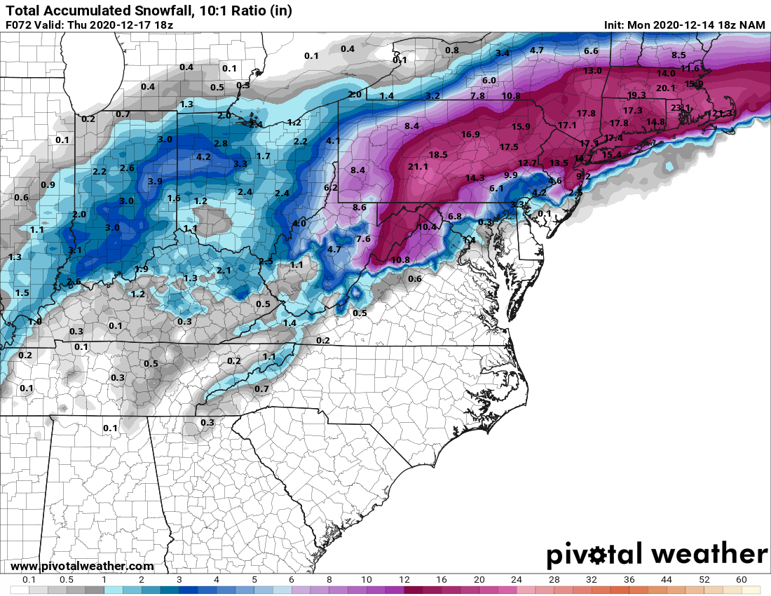
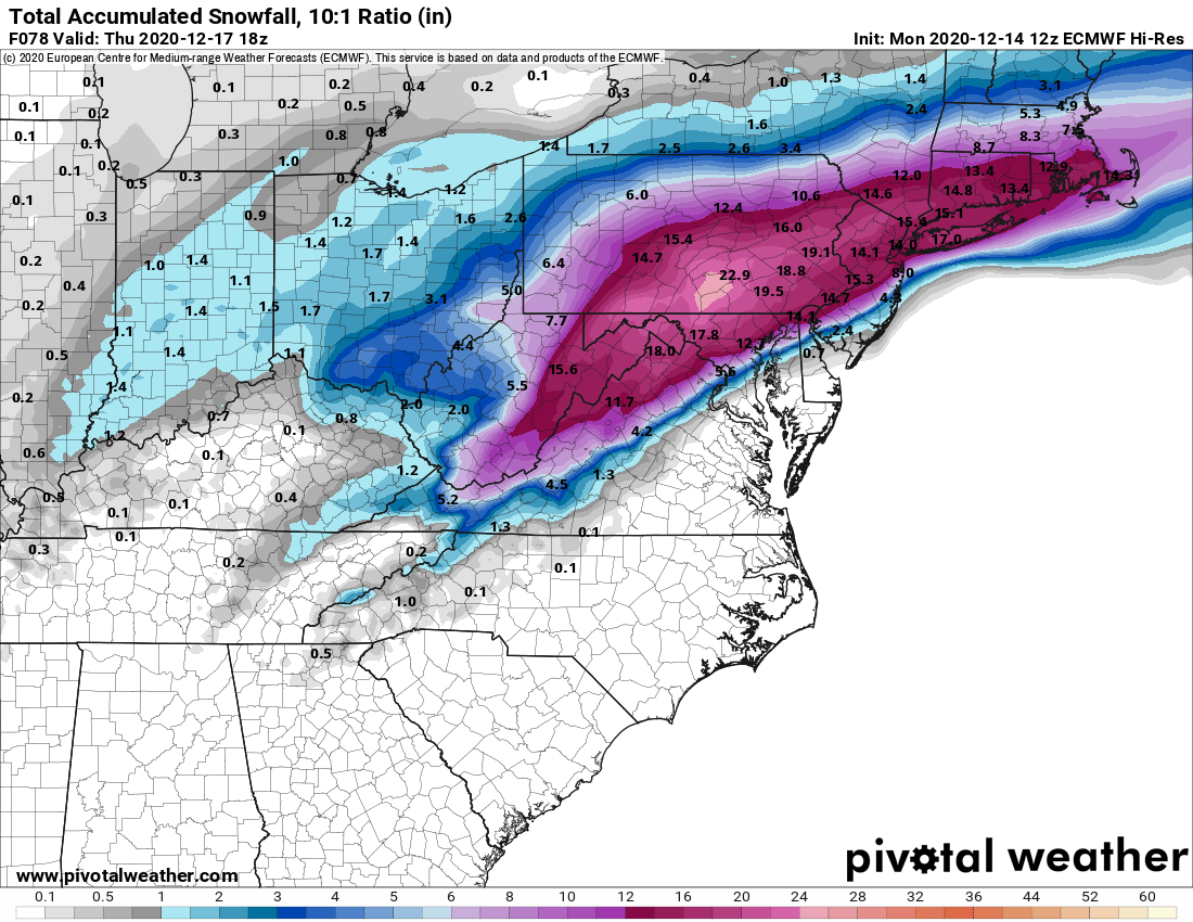
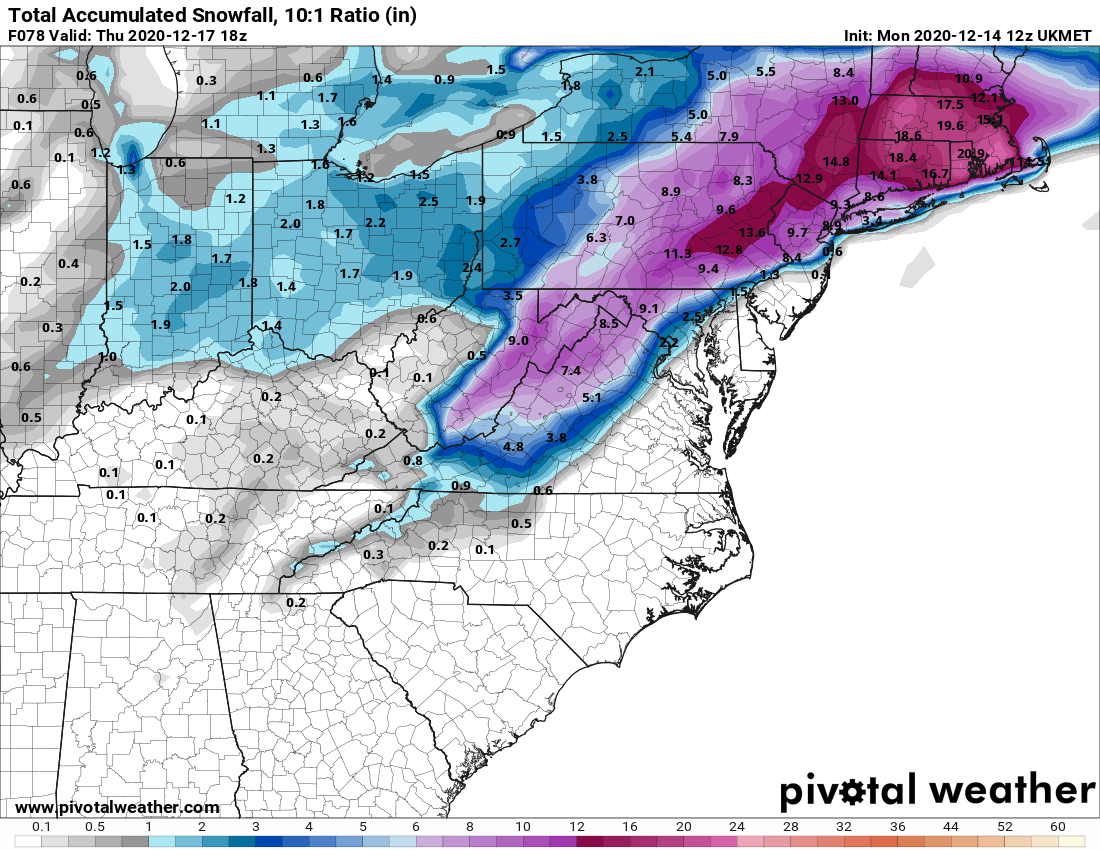
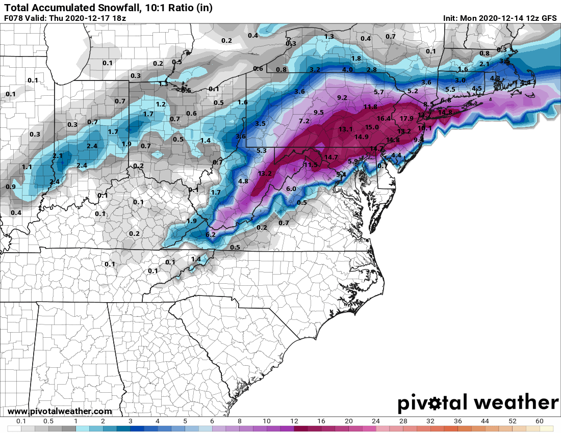
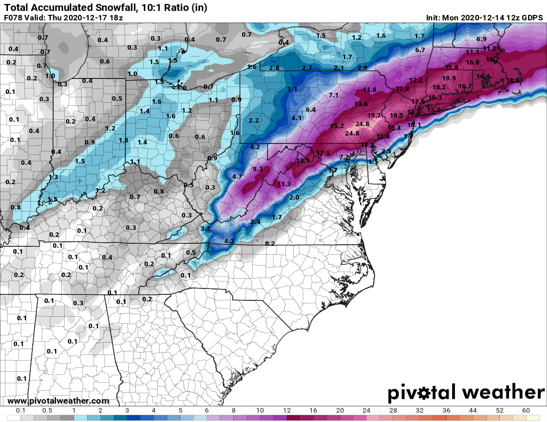
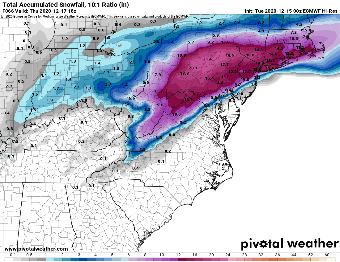
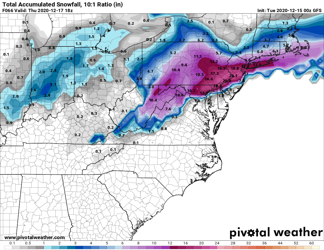
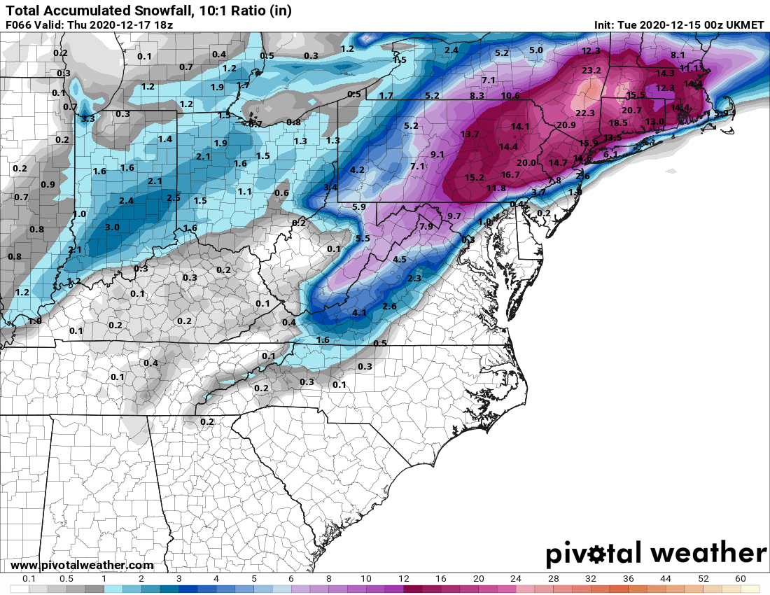
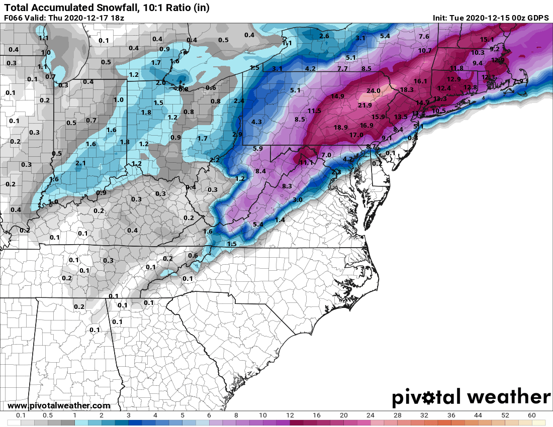
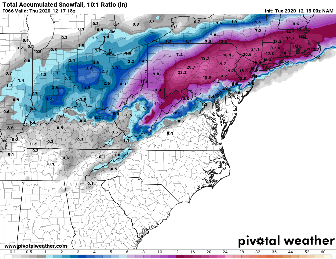
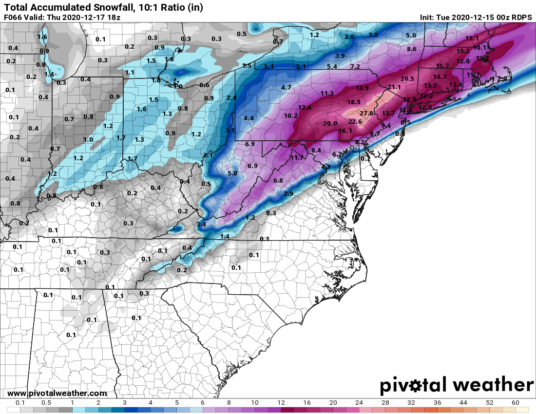
Basically, the Euro, UK and CMC all moved a bit SE with their snow fields, as the confluence was a bit stronger (the push of the strong cold air from the high in Canada), so the track of the low was a bit further SE, meaning the snow/rain (or snow/sleet) lines moved SE a bit (like 10-20 miles, which isn't a lot, but makes a big difference for some), more towards what the GFS had been showing - and the GFS moved significantly further NW with its track and snow field, meaning the models are closer together than they were the last 2 cycles, but still some differences obviously.
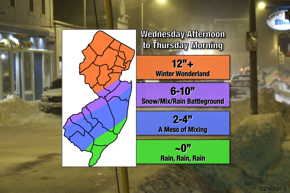
If you live along or NW of the 95 corridor, prepare for a major (8" or more) snowstorm, with 12" or more possible especially just NW of 95 and anywhere NW of there. Just SE of 95 and towards the coast will likely be the battleground for snow/sleet/rain at times. Also by early Thursday, after about 1 am, most folks should be snowing and the winds will increase to blizzard levels, so it should be pretty wild from maybe 1 am to 7 am. Below are the 4 global models I've been showing. Will likely add the NAM/RGEM tonight, as they'll be within 48 hours of the event start.
My 2nd least favorite weather person (after Sam Champion)...
We're pretty much neighbors, and I'm getting the same sinking feeling looking at these latest maps. That rain/snow line is too close, and when it's too close, the rain wins out and the snow totals are pitiful. Meanwhile, they'll be balling out in Pennington.Looks like the lowered the totals near me from 13” to 11”. I’m just north of 195 in Hamilton. I have a feeling it’s gonna keep going down the closer we get. I’d be surprised if I end up with over 6”
Imagine an adult wanting a lot of snow. I mean, you can. I'll just never understand it. Kind of like someone voluntarily spending 4 years in Syracuse or State College.
awesome!!!!!!If you're sitting there (like I am) wondering what the latest update will be from our resident weather folks, you should be listening to this:
XPN's 2020 Countdown - ALL TIME GREATEST SONGS
Listener votes have been cast. The list has been tallied. And on Thursday, December 10th, The WXPN 2020 Countdown begins. It’s the greatest songs of all time!
The top 2020 greatest songs of all time, as voted on by listeners of WXPN (UPenn station). You can livestream it while you do whatever else you're doing. They are up to #687, and the mix of songs is really unbelievable, although as they get closer to #1 it will become fewer artists, most likely. You can read the list for fun at this page, as well.
Go! Do it, now!
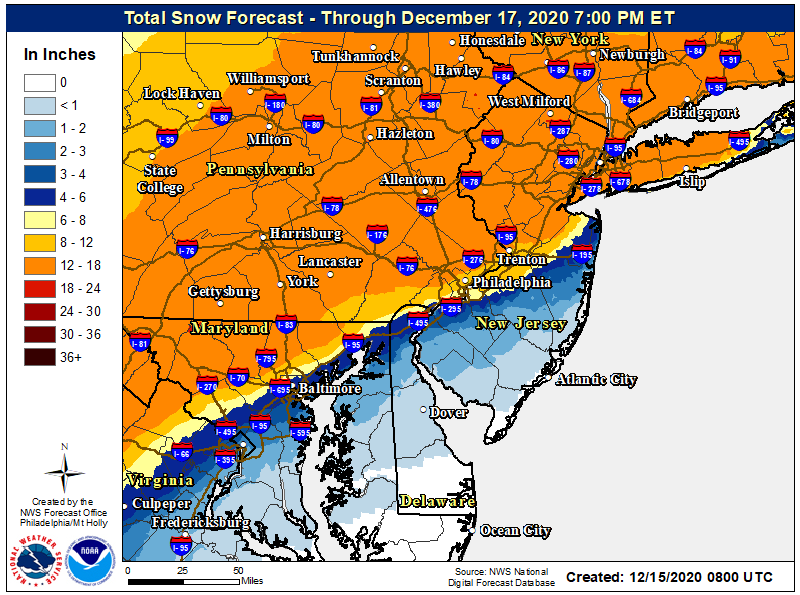
Their “oath”?I also think Mt Holly is too bullish for Somerset County having them in the 18-24 range. As my first call given overnight models i like a 8-14 inch call from Trenton to Somerville. I think we could see some lollipops of 12-16 in Somerset. 10-16 probably covers Hunterdon/Morris. Middlesex and Union I think 8-14 as well with some isolated higher amounts. As we get to Monmouth things get dicey with big cut off in amounts. We will go with 4-8 but some areas could go higher. Ocean County looks to be on the edge and might see 1-2 inches of slush. Philly and Burlington perhaps 6-10 but further in south jersey maybe 3-6 if that.
NW Nj could see the highest amounts of 12 -18 with lollipops of 20 inches. I see Nyc in the 8-12 range but that could be shaved
Things can be adjusted based on todays runs. Im not a fan of going with the heavier amounts unless there is more certainty. I do understand why Mt Holly is following their oath.