A
anon_ivydyf0amkzay
Guest
It’s multicultural and inclusive and stuff...:Wink:what stupid idiot had to name it that


Follow along with the video below to see how to install our site as a web app on your home screen.
Note: This feature may not be available in some browsers.
It’s multicultural and inclusive and stuff...:Wink:what stupid idiot had to name it that
That's the most likely outcome - I'll be heading down the Shore to see it if it comes close enough, like I do with almost any tropical system that comes close.
I would start with the following lists:I think they put @T2Kplus10 in charge of naming this year... :>)
Spoke too soon - been busy all afternoon and didn't see the 12Z models. Euro and UK both have a FL landfall of a weaker storm and it heading inland in FL (with the remnant low heading towards us, inland, with big rains), while GFS has it scraping the FL coast and then staying off the coast near NJ. Expect to see a shift west with the track, but thankfully, there has been no strengthening today and shear is an issue, which will hopefull prevent significant strengthening (but waters are warm, so need to watch).
Told my dad to stay put, as he can weather a minimal cat 1 in Vero and it's not worth evacuating with the COVID risk. You heard it here first: it's a Pandemicane!
Trademark that- you know it’s going to be a thing.Spoke too soon - been busy all afternoon and didn't see the 12Z models. Euro and UK both have a FL landfall of a weaker storm and it heading inland in FL (with the remnant low heading towards us, inland, with big rains), while GFS has it scraping the FL coast and then staying off the coast near NJ. Expect to see a shift west with the track, but thankfully, there has been no strengthening today and shear is an issue, which will hopefull prevent significant strengthening (but waters are warm, so need to watch).
Told my dad to stay put, as he can weather a minimal cat 1 in Vero and it's not worth evacuating with the COVID risk. You heard it here first: it's a Pandemicane!
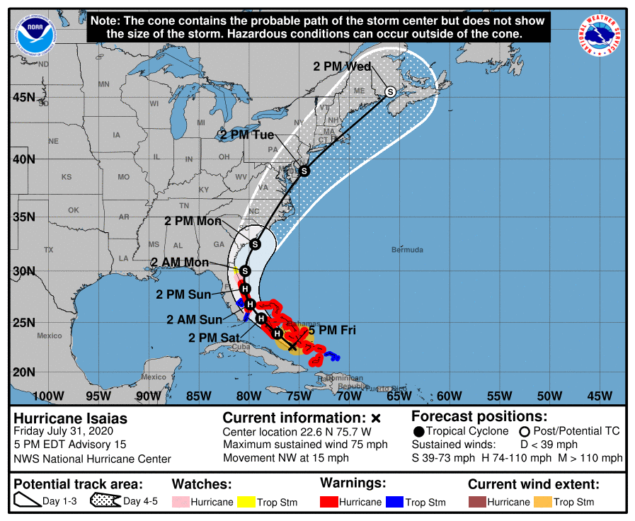
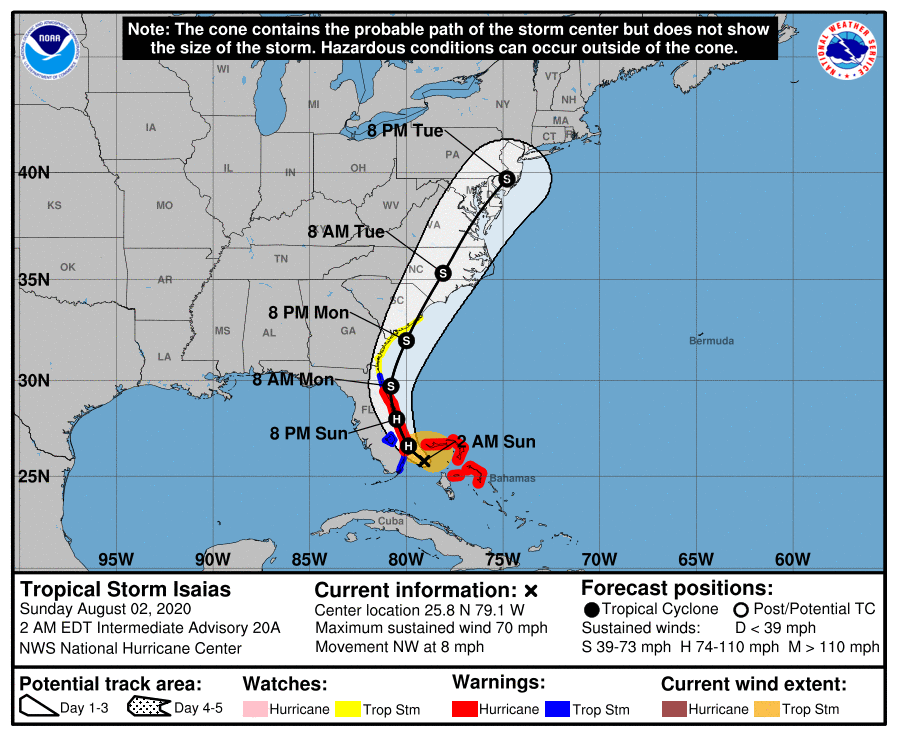
Yep, the NHC moved the track west by 20-30 miles, but not as far as we just saw in the Euro/UK, although I understand not wanting to just jump around in response to models, plus these guys do know a few things. Anyway, the forecast track has Isaias battering the Bahamas for the next 24-30 hours and then coming within about 10 miles of the FL coast at West Palm Beach as a Cat 1 hurricane (80 mph winds) around 2 am Sunday and then paralleling the coast almost exactly from there to about Cocoa Beach, where the storm would make its closest approach at Cape Canaveral, literally <5 miles from the coast, around 2 pm Sunday
After that, the forecast track bends north a bit and further offshore until it makes another approach to within about 25 miles of Charleston, SC early Monday afternoon, with another landfall predicted somewhere between Myrtle Beach and Wilmington, NC early Monday evening as a 70 mph tropical storm. The forecast then brings Isaias to just off the DelMarVa and SNJ coasts (like 10-20 miles) early Tuesday afternoon with 60-65 mph winds. The storm will then start transitioning to an extratropical system as it grazes Eastern LI and then likely strikes Cape Cod, still with 60 mph winds.
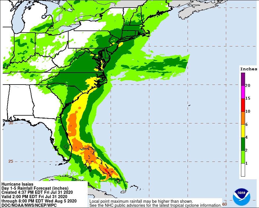
The biggest threat for most people along the path of this storm will likely be heavy, flooding rains, especially in FL, where the storm will be moving more slowly, with 3-6" of rain possible for many. Assuming no major strengthening, 75-80 mph winds can bring some damage, but not catastrophic widespread damage (but trees can come down, which can be catastrophic for someone). The biggest risk, though, is unexpected strengthening before a FL landfall, as there's a huge difference between a 75 mph hurricane and a 115 mph one - the forecast doesn't go above 85 mph, but intensity forecasts are just not that accurate - we better hope the wind shear keeps this from blowing up as it traverses the Bahamas towards Florida.
Similarly, there could be 2-4" rains near/along the coast from SC to New England, with that amount of rain likely for our entire Philly-NYC region, as the storm becomes more extratropical with an expanded precip shield. Storm surges could also bring some modest flooding in FL, SC, and NC, but probably less in NJ/NY.
https://www.nhc.noaa.gov/r…/graphics_at4+shtml/205732.shtml…
https://www.wunderground.com/…/2020-07-31-hurricane-warning…
https://www.americanwx.com/…/53557-hurricane-isa%C…/page/26/

Are you joking or do you expect models to be accurate 8-9 days out before a tropical system has even formed?I've been watching since last sunday..when there was 1 of 13 tracks heading for The Cape Fear region... now they are all going that way.....
models my ass,,,,,,,,
Very little change with the 11 pm NHC update. Hurricane is still at 80 mph, which is a good sign (no strengthening) and the predicted track and intensity are almost identical to 5 pm, so no detailed analysis with this post. Here's the track, below. Let's see what the 0Z models say, tonight...
Are you joking or do you expect models to be accurate 8-9 days out before a tropical system has even formed?


Actually it weakened overnight and is picking back up in strength - at 11 PM they were listing it at 70 mph.The 11 am NHC update is out and Isaias weakened slightly from 85 to 80 mph winds, as shear and dry air from the SW are keeping a full eyewall from forming, which is necessary for strengthening.
Nope, was 75 at 5 pm, 80 at 11 pm (look at the graphic I pasted at 11 pm), and 85 at 2 am, so it clearly strengthened a little overnight.Actually it weakened overnight and is picking back up in strength - at 11 PM they were listing it at 70 mph.
Storm is forecast to have 55-60 mph winds, assuming it remains just offshore of NJ; however, it has weakened a bit, so that could impact downstream strength, plus winds would be less if the storm actually stays inland longer - bottom line is that this is not a huge wind event for us. The 2-4" rains (with locally 5-6" in spots) are the story for our area, with urban/stream flooding likely in some areas. Coastal flooding should be minor, but there will be heavy surf/rip currents.Projected wind speeds in NJ?
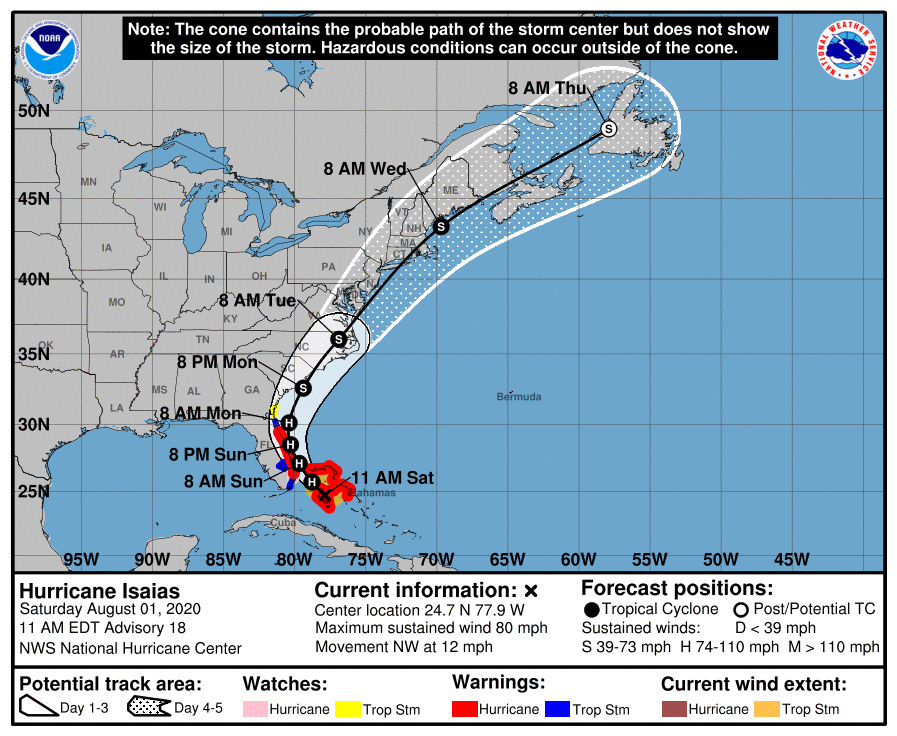
The 11 am NHC update is out and Isaias weakened slightly from 85 to 80 mph winds, as shear and dry air from the SW are keeping a full eyewall from forming, which is necessary for strengthening. The storm only has about 12-18 hours left for major intensification, before coming close enough to FL that land interaction would limit the chances of strengthening. The track is almost identical to last night - maybe nudged 5 miles east.
The storm is now forecast to only be about 10-15 miles off the coast, at least from about West Palm Beach to Cape Canaveral and is now expected to make a SC/NC border landfall and come very close to the DE/NJ/LI coasts (as a strong tropical storm) and then strike Cape Cod. The most encouraging thing is that, so far, there hasn’t been strengthening, due to shear and dry air entrainment as mentioned above, which is expected to continue, such that the forecast is for “only” 80-85 mph winds.
Anyway, the forecast track has Isaias battering the Bahamas for the next 12 hours and then coming within about about 10-15 miles of the FL coast at West Palm Beach as a Cat 1 hurricane (with ~80 mph winds) around 8 am Sunday and then paralleling the coast almost exactly from there to about Cocoa Beach, where the storm would make its closest approach at Cape Canaveral, literally <10 miles from the coast, around 8 pm Sunday. Also, keep in mind that the error bars on the track are 30-50 miles for the track near Florida, so a Florida landfall is still possible.
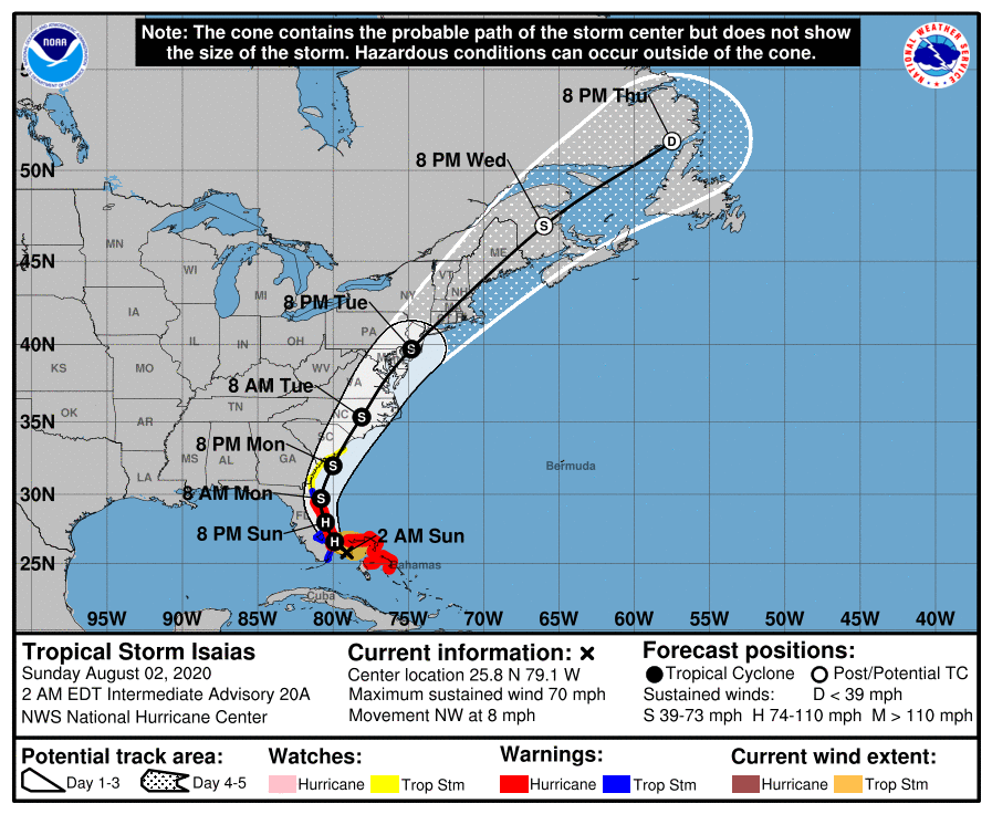
After that, the forecast track bends north a bit and further offshore until it makes another approach to within about 25 miles of Charleston, SC Monday afternoon, with another landfall predicted somewhere between Myrtle Beach and Wilmington, NC late Monday evening as a 70 mph tropical storm. The forecast then brings Isaias to just along the DelMarVa coast and just off the SNJ coast (like 10-20 miles) early Tuesday afternoon with 55-60 mph winds. The storm will then start transitioning to an extratropical system as it clips Eastern LI and then likely strikes RI/SE Mass (especially Cape Cod), still with 50+ mph winds.
The biggest threat for most people along the path of this storm will likely be heavy, flooding rains, especially in FL, where the storm will be moving more slowly, with 3-5" of rain possible for many, especially near the coast - however, if the asymmetry of the rain shield is preserved (much more rain to the east of the storm's center) and the storm stays off the coast, coastal areas may only get 1-2" of rain. Assuming no major strengthening, 80 mph winds can bring some damage, but not catastrophic widespread damage (but trees can come down, which can be catastrophic for someone).
The big risk of unexpected strengthening before a FL landfall is almost over, as the storm has limited time before land interactions and is still ingesting dry air with shear. And actually, it's now more likely that the storm weakens appreciably from these factors - right now the storm has certainly become more ragged looking.
Similarly, there could be 2-4" rains near/along the coast from SC to New England, with that amount of rain likely for our entire Philly-NYC region, as the storm becomes more extratropical with an expanded precip shield. Storm surges could also bring some modest coastal flooding in FL, SC, and NC, but probably less north of NC. Tuesday is likely to be a hellacious day around here with flooding rains and tropical storm winds for most, especially near the coast – let’s hope the storm moves as quickly as forecast to keep the rainfall amounts from becoming huge.
https://www.nhc.noaa.gov/text/refresh/MIATCDAT4+shtml/010245.shtml?
https://www.wunderground.com/articl...aias-evacuations-shelters-coronavirus-covid19
https://www.americanwx.com/bb/topic/53557-hurricane-isaías/page/31/

#bustQuick update. Isaias weakened a bit further and is now a tropical storm with 70 mph winds, as the dry air entrainment and SWerly shear have really killed any convection/precip around the storm, which is the key to the energy of any warm core tropical system (huge release of latent heat from condensation of evaporated moisture into clouds/rain). However, in the last hour, a big convective blob formed on the north side of the storm, so it's trying to restrengthen and is still forecast to be a minimal hurricane (75 mph) during its path up the Florida coast.
The track is very similar to before, although it looks like it was nudged back west about 5-10 miles or so, such that the track is now maybe only 5-10 miles off the FL coast from early Sunday through early Monday and it moved about 10-20 miles west north of FL, with landfall now in the NE coast of SC near Myrtle Beach as a 60-65 mph tropical storm and then heading through eastern NC and VA and then just grazing the coasts of DE/SNJ before striking central LI/CT/RI/SE Mass, with generally ~50 mph winds being forecast for that part of the track.
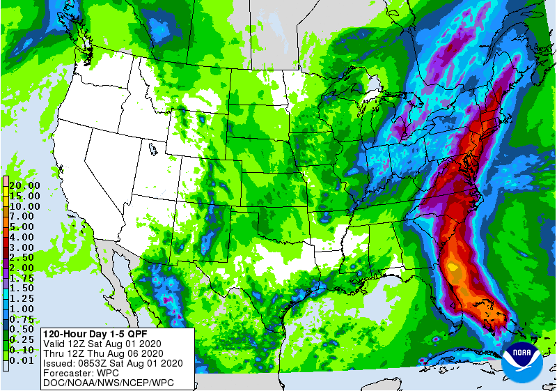
As I've been saying, this is mostly a rain threat, with 2-4" (and up to 5-6" in some locations) of rain for coastal sections from FL to Maine (and for all of our region, as the precip shield will expand as the storm heads north and loses some of its tropical characteristics). Looks like we're likely to have dodged a large bullet, especially for Florida, although let's see what happens before celebrating (surprise intensification has occurred before).
I love how precip magically decreases or increases depending on which side of the MD PA border you call home...the NWS offices need to learn the art of coordinating.
Tropical Storm Isaias Update
We continue to monitor Tropical Storm Isaias. Models still differ on details for our area, but we will see increased confidence in the forecast as the storm develops. The primary threat to our area is heavy rain.
⌚️Timing
• Isaias is forecast to impact New Jersey as a Tropical Storm.
• Impacts are expected to span from late Monday night into Tuesday night.
Summary of Impacts
• We can expect impacts from late Monday through Tuesday.
• Details are forthcoming for quantities, but we may expect on Tuesday:
o Elevated surf and rip currents
o Potential for spotty minor coastal flooding
o Gusty winds with possible Tropical Storm Force winds in coastal counties
o Heavy rain
o Inland flooding where rainfall is heaviest
First it is. AND very good.(the name,NOT the storm)Spoke too soon - been busy all afternoon and didn't see the 12Z models. Euro and UK both have a FL landfall of a weaker storm and it heading inland in FL (with the remnant low heading towards us, inland, with big rains), while GFS has it scraping the FL coast and then staying off the coast near NJ. Expect to see a shift west with the track, but thankfully, there has been no strengthening today and shear is an issue, which will hopefull prevent significant strengthening (but waters are warm, so need to watch).
Told my dad to stay put, as he can weather a minimal cat 1 in Vero and it's not worth evacuating with the COVID risk. You heard it here first: it's a Pandemicane!
FWIW, this story projects 4-6 inches -- but says this storm may be unconventional by have the bulk of the precipitation on the eastern side, which would make it largely a fish storm. https://www.nj.com/news/2020/08/hur...ome-relief-to-abnormally-dry-areas-of-nj.html
Thanks. Also thought about Coronacane - surprised we haven't seen either used yet...First it is. AND very good.(the name,NOT the storm)
Quick update. Isaias weakened a bit further and is now a tropical storm with 70 mph winds, as the dry air entrainment and SWerly shear have really killed any convection/precip around the storm, which is the key to the energy of any warm core tropical system (huge release of latent heat from condensation of evaporated moisture into clouds/rain). However, in the last hour, a big convective blob formed on the north side of the storm, so it's trying to restrengthen and is still forecast to be a minimal hurricane (75 mph) during its path up the Florida coast.
The track is very similar to before, although it looks like it was nudged back west about 5-10 miles or so, such that the track is now maybe only 5-10 miles off the FL coast from early Sunday through early Monday and it moved about 10-20 miles west north of FL, with landfall now in the NE coast of SC near Myrtle Beach as a 60-65 mph tropical storm and then heading through eastern NC and VA and then just grazing the coasts of DE/SNJ before striking central LI/CT/RI/SE Mass, with generally ~50 mph winds being forecast for that part of the track.
As I've been saying, this is mostly a rain threat, with 2-4" (and up to 5-6" in some locations) of rain for coastal sections from FL to Maine (and for all of our region, as the precip shield will expand as the storm heads north and loses some of its tropical characteristics). Looks like we're likely to have dodged a large bullet, especially for Florida, although let's see what happens before celebrating (surprise intensification has occurred before).
With the storm looking like it will have a direct impact in New Jersey, what are the anticipated winds? I’m presuming around 40-50 mph or so which will be problematic along with flooding etc. Hopefully damage is minimal.

The Covid thread is a mess. Another reboot is probably needed.Which has more wind? Isaias or Covid 19 thread?
I have to cut my lawn on Wednesday. Do you think I should postpone it or do it Tuesday?

From what I have been reading, it would be from the duration of the storm.What time is this supposed to hit ?
And is it supposed to dump these 2-4 inches in a couple hours or a full day ?
From what I have been reading, it would be from the duration of the storm.
Definitely. Still not great, but manageable. Just hope this thing isn’t a slow mover. That’s when you get the big rain dumps.well, I would assume that’s better than getting a 4 inch dump in 2 hours
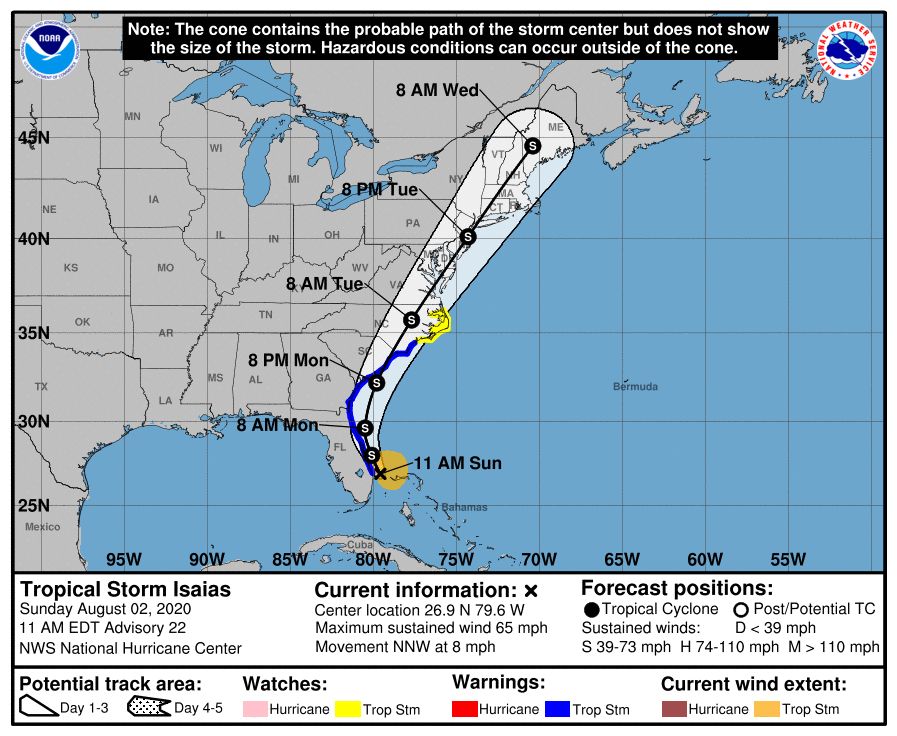
Update. Isaias is still a tropical storm with 70 mph winds as of 2 am although as of 2:30 am the hurricane hunters have found surface winds to be at 73-74 mph, so it's possible we have a minimal hurricane again, although not really much difference between 70 and 75 mph. Lots of fluctuations in convection with much of it still being blown off from the center towards the NE, by SWerly shear, which has prevented much precip from falling west of the track, in Florida and has prevented strengthening. With the storm now getting very close to FL, the chances of surprise intensification are near zero, with some of the circulation starting to be over land.
The forecast track was nudged slightly west across the board with the track now bringing the center of the storm within 5 miles of the FL coast from West Palm Beach (around 8 am Sunday) through about Daytona Beach (around 2 am Monday), as a 75 mph minimal hurricane with a forecast landfall right on top of Cape Canaveral, which juts out into the Atlantic about 5-10 miles. There could be a 2-4 foot storm surge along most of the FL coast, which could bring some minor to moderate coastal flooding.
Beyond FL, the storm is forecast to continue paralleling the east coast, making a 2nd landfall somewhere between Charleston and and the SC/NC border (a wide spread, given the angle of approach) late Monday evening, as a 65-70 mph tropical storm, and then traveling inland through eastern NC/VA, the DelMarVa and into SE NJ just 10-20 miles inland of the coast, being in the vicinity of Hammonton, NJ by about 8 pm Tuesday, as a 45-50 mph tropical storm. The storm is then forecast to go right over Perth Amboy and eastern NYC Tuesday night and then through CT, MA and coastal NH/ME, while completing its transition from a tropical (warm core) system to an extratropical (cold core) system.
Once again this is mostly a rain threat, with 2-4" (and up to 5-6" in some locations) of rain for coastal sections from FL (where only 1-2" might fall along the coast, as most of the precip in that area will be east of the storm's track) to Maine. All of our region will likely get 2-4" of rain with 5-6" amounts in spots, as the precip shield will expand to the NW of the storm's track as the storm heads NE after landfall in SC/NC and starts to lose some of its tropical characteristics, so urban/stream flooding is likely in some locations, although much of the area is drier than normal, which should temper stream flooding. There will be a full moon in our area, so minor to locally moderate coastal flooding is possible on Tuesday with the lunar addition of about 1 foot to high tides.
https://www.nhc.noaa.gov/text/refresh/MIATCDAT4+shtml/020256.shtml?
https://www.wunderground.com/articl...m-hurricane-isaias-florida-carolinas-forecast
https://www.americanwx.com/bb/topic/53557-tropical-storm-isaías/page/38/
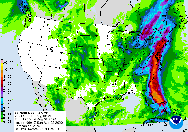
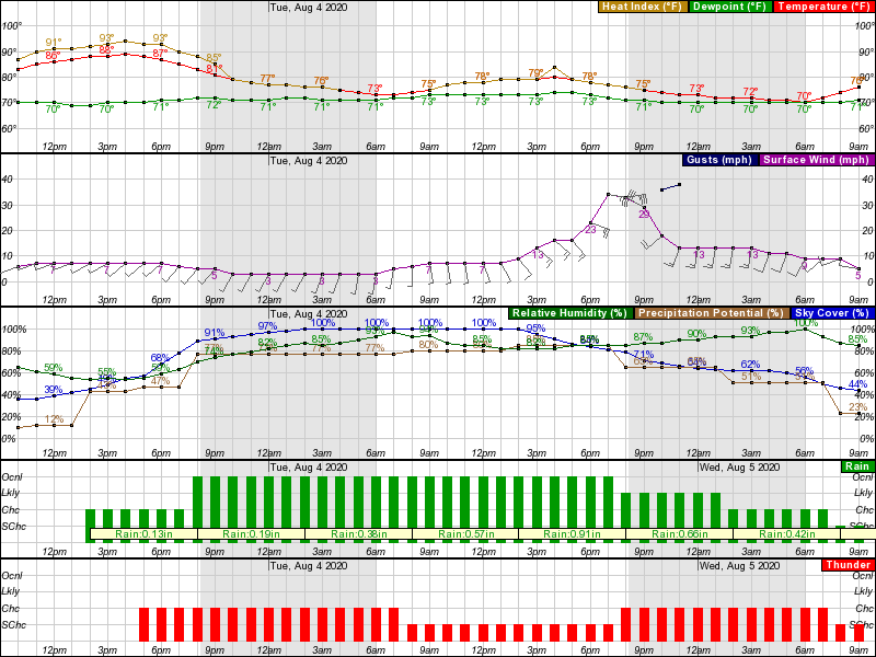
Definitely spread out over all of Tuesday, as per the NWS graphic for the Edison area (similar everywhere else), which adds up to a little over 3" of rain - note that the rain before about noon on Tuesday is due to what's called a "predecessor rain event" where the moisture fetch from the storm and a jet streak aloft in our area sparks off showers/rain well before the storm gets here. Also shows the peak wind gusts being in the 30-40 mph range as the storm center reaches this area Tuesday early evening.Definitely. Still not great, but manageable. Just hope this thing isn’t a slow mover. That’s when you get the big rain dumps.
Conditions should be fine by then - only question is whether the expected delays from Tuesday evening could have a knock on effect for the next day.I’m supposed to fly out of Philly at 6am on Wed morning. Think it will be OK?
With the storm looking like it will have a direct impact in New Jersey, what are the anticipated winds? I’m presuming around 40-50 mph or so which will be problematic along with flooding etc. Hopefully damage is minimal.
