The precursor, and the road grader for the ass-kicking we will get tomorrow. The other side of Wall got hammered by the storm tonight.
Build the Wall


Follow along with the video below to see how to install our site as a web app on your home screen.
Note: This feature may not be available in some browsers.
The precursor, and the road grader for the ass-kicking we will get tomorrow. The other side of Wall got hammered by the storm tonight.
5 minutes of rain, big bust IMBY
Wow. 91 mph gust at Oak Island NC, just east of the SC border...

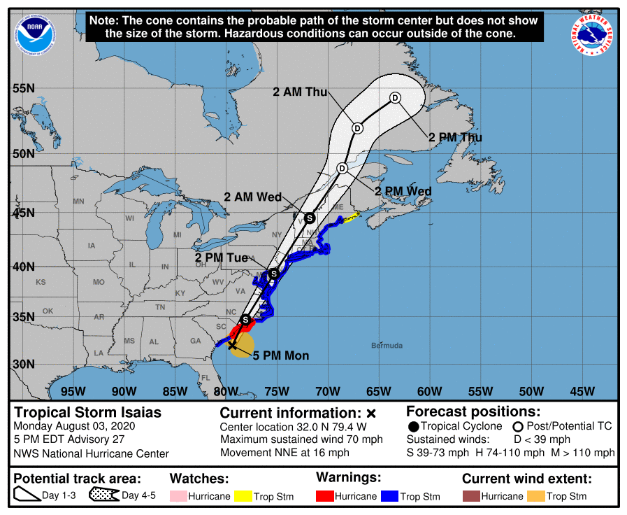
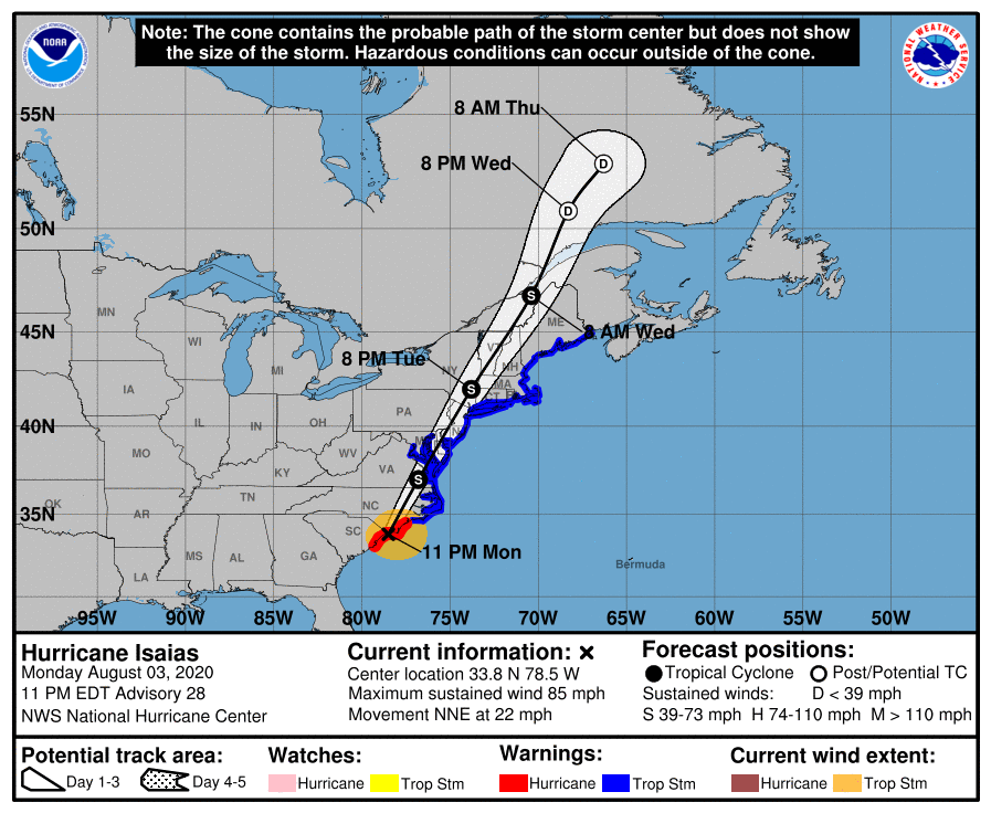
Pretty much the same forecast track (maybe nudged 5-10 miles to the east, right up the 95 corridor from Philly to NYC) and intensity (70-75 mph at landfall in NE SC to ~60 mph in our area). Highlights below and some graphics/links.
https://www.weather.gov/phi/
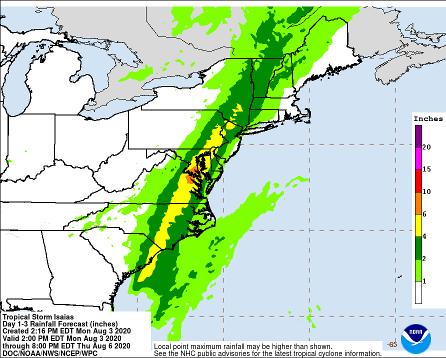
- The one change in this forecast is a steeper gradient of rainfall from SE to NW with 1-2" along the coast, 2-4" from the coast to 95, and 3-6" from 95 to points well NW of 95.
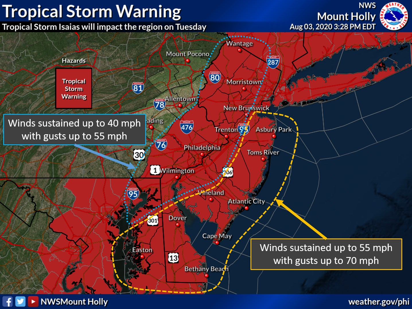
- Expecting the worst winds from about 2-6 pm in CNJ (earlier to the south/later to the north), as the storm's center approaches our area.
- Forecast calls for 50-55 mph sustained and gusts up to 70 mph along/near the coast and ~40 mph sustained with gusts to 55 mph inland (from just SE of 95 to all points NW of there).
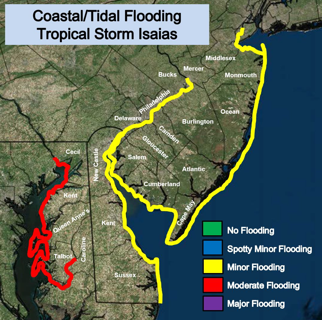
- Coastal flooding should be minor in most locations, but perhaps moderate in Delaware/Chesapeake Bays.
- Still a low chance of isolated small tornadoes to the SE of the storm's track, i.e., along and SE of the 95 corridor.
https://www.facebook.com/NWSMountHolly/
https://www.wunderground.com/articl...-storm-isaias-forecast-mid-atlantic-northeast
https://www.nhc.noaa.gov/text/refresh/MIATCDAT4+shtml/030243.shtml?
https://www.americanwx.com/bb/topic/53557-tropical-storm-isaías/page/51/

Wow, are you down there in eastern NC somewhere? Good luck man.11:39pm...........
2-3 Tornado warnings over last few hours.
On-and-off heavy rain w/ thunder.... a few big gusts... but overall - so far so good.....
Eye wall looks like it'll pass by about 10 miles to the west.....
Cantore is still fun to watch.We have landfall. Cantore is actually getting hammered in the NE part of the eyewall in Wrightsville Beach. Still love his reports.
Hurricane Isaias Tropical Cyclone Update
NWS National Hurricane Center Miami FL AL092020
1115 PM EDT Mon Aug 3 2020
Doppler radar imagery and surface observations indicate that eye of
Hurricane Isaias made landfall in southern North Carolina
around 1110 PM EDT (0310 UTC) near Ocean Isle Beach, with maximum
sustained winds of 85 mph (140 km/h).
A weather station at Oak Island, North Carolina, recently reported
sustained winds of 76 mph (122 km/h) and a gust to 87 mph (140
km/h).
A data buoy near the coast of North Carolina has recently reported
a minimum pressure of 988 MB (29.18 inches).
SUMMARY OF 1115 PM EDT...0315 UTC...INFORMATION
-----------------------------------------------
LOCATION...33.9N 78.4W
ABOUT 40 MI...65 KM SSW OF WILMINGTON NORTH CAROLINA
MAXIMUM SUSTAINED WINDS...85 MPH...140 KM/H
PRESENT MOVEMENT...NNE OR 20 DEGREES AT 22 MPH...35 KM/H
MINIMUM CENTRAL PRESSURE...988 MB...29.18 INCHES
Wow. 91 mph gust at Oak Island NC, just east of the SC border...
On plus side, it should be out of here by early afternoon.Storm is really moving at 28MPH , which the Weather channel is saying will now give winds less time to slow down when it hits NJ
On plus side, it should be out of here by early afternoon.
NWS really cut down the rain totals here along the shore near Manasquan, as well as inland including Allentown, PA.
How's the surf?on the plus side the boardwalk was empty this morning for my AM bike ride
He also ordered to brine the roads. You know, just in case.Murphy closes the state for this? lol
Nice, just after my workday wraps up. FYI, forecast winds in our area down to only 32 mph. Summer T-storm is normally worse.Sun out by 4pm
50 mph here in Monmouth with 70 mph gusts. That is not to be taken lightly.Nice, just after my workday wraps up. FYI, forecast winds in our area down to only 32 mph. Summer T-storm is normally worse.
Murphy closes the state for this? lol
Peak sustained wind in Brick down to 35 mph at 2pm.50 mph here in Monmouth with 70 mph gusts. That is not to be taken lightly.
Well that's good news.The Delaware River is expected to flood downtown Trenton and Route 29 that is why Trenton closed
Well, then- go fly a kite!Peak sustained wind in Brick down to 35 mph at 2pm.
The Delaware River is expected to flood downtown Trenton and Route 29 that is why Trenton closed
Why is it funny? Hurricanes and tropical storms are dynamic events and hard to predict. There are multiple tornado warnings in Delaware, NJ and Eastern Pennsylvania. Is that funny?Somerset County rainfall prediction 1 inch . LOLOL
Mercer County Trenton 2inches LOLOL
Where you seeing this?Somerset County rainfall prediction 1 inch . LOLOL
Mercer County Trenton 2inches LOLOL
Dan Zarrow 101.5 blogWhere you seeing this?