More model mayhem at 12Z today (7 am EST data inputs; results coming out now), with the following highlights below (would require 2-3 maps per model to show all the nuances given mixed precip, so words for now, lol. Suffice it to say that this is a very complex setup as we really have two lows: one approaching from the Ohio Valley and weakening near us and then a secondary coastal low forming that is mostly going out to sea, but does bring some precip in some models, especially near the coast (rain in most, but not all models).
If the coastal were to come up the coast, we'd be talking at least a significant snowstorm for almost everyone, assuming it brought enough cold air in from the NE (not a given, so rain would also be possible). We've seen that in previous model runs, including last night, and in many model ensemble members, where the parent model is tweaked with variations in initial/boundary conditions to gauge the sensitivity of the model to these perturbations, especially since the data inputs are often sparse and inaccurate, so one run of the operational model is often insufficient to evaluate the output. So, we're almost 4 days out from the event starting and there is a huge range of outcomes possible, with high levels of uncertainty on any solution. It's why we track.
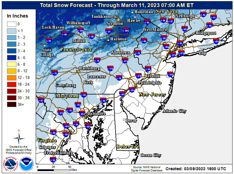
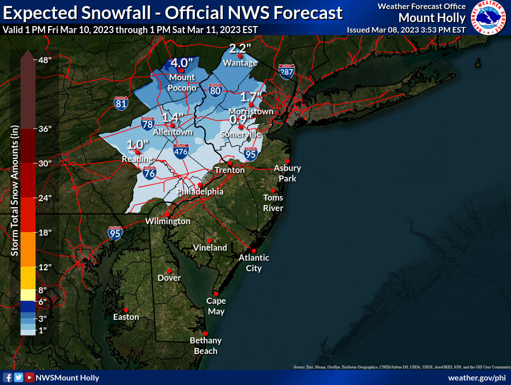
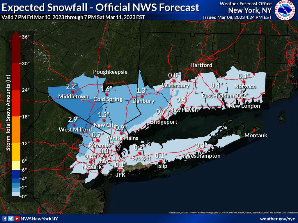
One more point: so far, the NWS is not very enthusiastic for this event, as their thinking is that this will be mostly a rainstorm, except for areas NW of 95 and especially N of 78, but they do tend to start out conservatively, which I actually like, since there are so many things that can go wrong to prevent snow around here, especially in mid-March along and SE of 95. I'd rather them do that than tout the occasional model run that shows a huge snowbomb when most others aren't (like last night's Euro for the Monday event - no other models showed that). Included links to the NWS page, the AmericanWx thread on this (33andrain is moving to a Discord site, which I don't know if it's viewable if not a member, unlike the boards) and to Pivotal Weather, which has all the models if anyone wants to look at them.
https://www.weather.gov/phi/
https://www.americanwx.com/bb/topic/58892-march-2023/page/37/
https://www.pivotalweather.com/model.php
3/12 Edit: changed thread title from "OT: Winter Storm 3/10-11 (Still High Uncertainty) and 3/13-14 (high potential/high uncertainty)" to current title.
If the coastal were to come up the coast, we'd be talking at least a significant snowstorm for almost everyone, assuming it brought enough cold air in from the NE (not a given, so rain would also be possible). We've seen that in previous model runs, including last night, and in many model ensemble members, where the parent model is tweaked with variations in initial/boundary conditions to gauge the sensitivity of the model to these perturbations, especially since the data inputs are often sparse and inaccurate, so one run of the operational model is often insufficient to evaluate the output. So, we're almost 4 days out from the event starting and there is a huge range of outcomes possible, with high levels of uncertainty on any solution. It's why we track.
- The GFS is showing significant snowfall (4-8") just NW of 95 with mostly rain along and SE of 95 from the initial low from the Ohio Valley late Friday night into early Saturday morning, followed by a secondary coastal forming and bringing several inches of snow to areas SE of 95 (and a lot more to SNE) Sat morning.
- The CMC is showing a minor to moderate snowfall (1-4") for most of the area, except rain near the coast from the initial low from the Ohio Valley late Friday night into early Saturday morning, the secondary coastal low goes out to sea w/little precip for anyone.
- The UK shows a minor to moderate snowfall (1-4") for areas well NW of 95 (maybe from New Hope to Montvale and NW of there) and mostly rain near/along 95 and to the coast from the initial low from the Ohio Valley late Friday night into early Saturday morning; again, the secondary coastal low goes out to sea w/little precip for anyone.
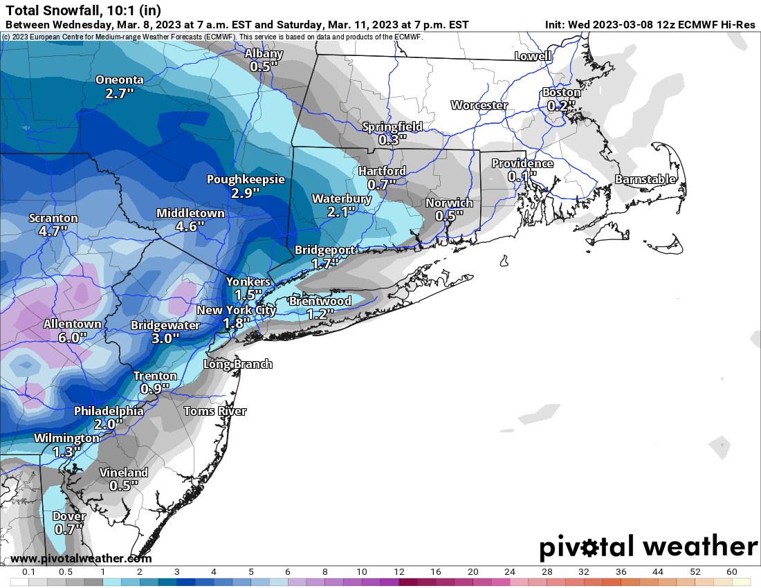
- The Euro is somewhat similar to the CMC in that it shows a moderate snowfall (2-4") for most of the area, except <1" near the coast (due to rain) from the initial low from the Ohio Valley late Friday night into early Saturday morning, while the secondary coastal low goes out to sea with a little bit of snow for along and SE of 95 to the coast.
One more point: so far, the NWS is not very enthusiastic for this event, as their thinking is that this will be mostly a rainstorm, except for areas NW of 95 and especially N of 78, but they do tend to start out conservatively, which I actually like, since there are so many things that can go wrong to prevent snow around here, especially in mid-March along and SE of 95. I'd rather them do that than tout the occasional model run that shows a huge snowbomb when most others aren't (like last night's Euro for the Monday event - no other models showed that). Included links to the NWS page, the AmericanWx thread on this (33andrain is moving to a Discord site, which I don't know if it's viewable if not a member, unlike the boards) and to Pivotal Weather, which has all the models if anyone wants to look at them.
https://www.weather.gov/phi/
https://www.americanwx.com/bb/topic/58892-march-2023/page/37/
https://www.pivotalweather.com/model.php
3/12 Edit: changed thread title from "OT: Winter Storm 3/10-11 (Still High Uncertainty) and 3/13-14 (high potential/high uncertainty)" to current title.
Last edited: