ADVERTISEMENT

OT: Maria devastates Puerto Rico, but is unlikely to make US east coast landfall

RU848789

Legend
Gold Member
Jul 27, 2001
60,512
39,095
113
Metuchen, NJ
Was talking about this yesterday in the Jose thread, as Tropical Storm Maria was named yesterday morning and is now a strong tropical storm and deserves its own thread.

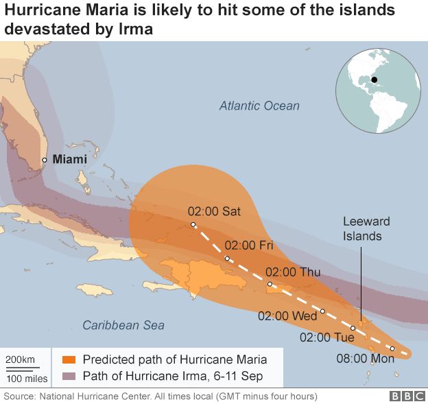
So, Maria has strengthened to almost hurricane status (65 mph) and is still forecast to become a major hurricane in 2-3 days (~125 mph winds) in 2-3 days, moving across the Leeward Islands, 50-100 miles south of Irma's track, so islands like Guadaloupe are in its path, and Maria is forecast to make a direct hit on Puerto Rico in about 4 days with ~125 mph winds and then to graze the NE coast of Hispaniola (Domincan Republic in particular) in 5 days.

Long term Maria's track is quite uncertain, but it's at least unsettling that the Euro, the best model for storms like Sandy and Irma and many others, shows Maria striking the SC/NC coast in 10 days. Way far off to actually predict a landfall there or anywhere, really, but the message is that interests along the US east coast need to pay attention to Maria.

https://www.americanwx.com/bb/topic/50285-tropical-storm-maria/?page=2
http://www.nhc.noaa.gov/graphics_at5.shtml?cone#contents

21463065_10212167748342967_4614030806248996637_n.jpg
 
Thanks for the info. Didn't even know there was another one. Feel bad for those that lost everything.

There will be thousands if not more that don't even bother to rebuild after that.
 
Is there an Olazabel in the names this year? Wouldn't it be cool if Jose stuck around long enough and we had a thread on three hurricanes titled

"Jose Maria Olazabal takes aim on the U.S.A"

Ryder old joke here for those of you who follow the Ryder cup
 
Last edited:
Is there an Olazabel in the names this year? Wouldn't it be cool if Jose stuck around long enough and we had a thread on three hurricanes titled

"Jose Maria Olazabal takes aim on the U.S.A"

Ryder gold joke here for those of you who follow the Ryder cup

 
Thanks for the info. Didn't even know there was another one. Feel bad for those that lost everything.

There will be thousands if not more that don't even bother to rebuild after that.

Hopefully, Maria "only" becomes a Cat 3, rather than the Cat 5+ monster that Irma was through the Caribbean, because Maria is taking dead aim at far more populated Leeward Islands, like Guadaloupe, Dominica and Martinique, plus it looks like a direct hit on Puerto Rico and perhaps the Dominican Republic - all of these locations were just on the periphery of Irma, getting some hurricane force gusts and heavy rains/seas/surf, but nowhere near what they got in Barbuda, Anguilla, and the British Virgin Islands, in particular (which are all far less populated).
 
It's gotta get its poopie together. Maria's endured some pretty strong shear through her initial formation and is within a day and a half of interacting with the middle Antilles, most of which have some pretty mountainous terrain. The storm's presentation, right now, is pretty poor and its current projected path provides a number of opportunities for disruption.
 
It's gotta get its poopie together. Maria's endured some pretty strong shear through her initial formation and is within a day and a half of interacting with the middle Antilles, most of which have some pretty mountainous terrain. The storm's presentation, right now, is pretty poor and its current projected path provides a number of opportunities for disruption.

Yep.
 
Maria has really gotten its act together this evening and is now a Cat 1 hurricane with 85 mph winds and is forecast to be in a low shear environment and passing over very warm waters, so strengthening - and probably major strengthening - is likely over the next 2 days.

The NHC forecast brings Maria to Cat 3 status (115 mph winds) in about 24 hours, as the storm hammers the central Lesser Antilles (Guadaloupe/Dominica/Martinique) and then St. Croix (which largely escaped the worst of Irma, while the rest of the US and British Virgin Islands were destroyed by Irma) in 2 days and then to Cat 4 status, with 140 mph winds in 3 days, just as the storm is making landfall on Puerto Rico.

Going directly over Puerto Rico will disrupt the circulation somewhat, weakening the storm a bit before grazing the NE coast of the Dominican Republic. After that, probably the SE Bahamas get hit, but the storm may then approach the US east coast in 8-9 days - too far out for any predictions, but this one really needs to be watched closely.

http://www.nhc.noaa.gov/text/refresh/MIATCDAT5+shtml/180249.shtml?

21742870_10212172786948929_4797816981400277651_n.jpg
 
The models are indicating that if Jose hangs around off the coast of the U.S. through the 8-9 day range, Maria goes out to sea. Looking at Maria's current track, it's gaining a lot of latitude and while the climatology suggests about a 40% chance of U.S. landfall (per the, as always, fabulous historical data presented by AmericanWx poster donsutherland) those chances will decrease as Maria continues to gain latitude. My guess is that in 24+ hours we'll be talking about Bermuda, more so than the U.S. east coast.
 
  • Like
Reactions: wonchobody
Most of last night's model runs, including the GFS and Euro, had Maria missing the east coast by a few hundred miles, as she recurves out to sea around Day 9-10. That's still a highly uncertain forecast, especially given the uncertainty around Jose's track and influence on the strength of the western Atlantic ridge, which is critical to steering currents for Maria. Still a threat for the US this far out. Puerto Rico is going to get hammered, though, unfortunately.
 
Shit's about to get real in the central Lesser Antilles and Puerto Rico. As feared and modeled, Maria is undergoing rapid intensification, from 90 mph at 5 am to 125 mph and strengthening still at 2 pm. NHC forecast is calling for Maria to be Cat 4 (130-145 mph) as it strikes the Lesser Antilles (places like Guadaloupe, Dominica and Martinique) in the next 12-24 hours and then to be about 150 mph as it strikes St. Croix and PR on Wednesday morning and then grazes the NE coast of the Dominican Republic on Thursday morning with possible 140-150 mph winds. Very uncertain if Maria comes close to the US east coast 8-10 days out - some models show her coming very close, especially to the Carolinas, and some (including the Euro) show her remaining well out to sea.

21559112_10212176925092380_5255889440189246243_n.jpg
 
Interesting graphic on the paths of Irma and Maria. God help those islands still recovering from Irma that are gonna get by Maria.

_97853855_hurricane.png
 
I'm not feelin' a U.S. landfall on this one. It's really hard to look at all that latitude that Maria is gaining and not see that, at some point very soon, it will have gotten far enough north that a U.S. landfall would require a retrograde.
 
This may sound like an inane technical question but my understanding is that these storms are strengthening due to the fact that the ocean temperatures in the Caribbean had been quite high. Has the rain from these storms cooled the oceans at all?
 
This may sound like an inane technical question but my understanding is that these storms are strengthening due to the fact that the ocean temperatures in the Caribbean had been quite high. Has the rain from these storms cooled the oceans at all?

The rain doesn't cool the waters so much as something called "upwelling". When a large, powerful cyclone passes over any given point, it's pulling vast amounts of water up into it, via evaporation. This disturbance, along with the perturbation caused by 100+ mph winds, agitates the surface and causes cooler water from depth to mix upward, reducing the overall temperature slightly.

You can actually see Irma's path on IR images of the ocean surface, where the water temperature is about a degree cooler.

It makes a little bit of a difference in the ability of a follow-up storm to rapidly intensify.
 
  • Like
Reactions: mdk01
We have friends Whit 2 son's that live in St. Thomas. They were both able to get out for Irma but this is the message that was sent out today regarding the new storm. (message was sent in all caps)

ACT DURING THIS WINDOW OF TIME BEFORE TUESDAY AFTERNOON.
URGENT: "WE ARE NO LONGER IN RECOVERY MODE. IT IS A PROTECTION AND SHELTER FROM THIS POINT FORWARD."
USE NATIONAL GUARD & VI HOUSING AUTHORITY SERVICES TO RELOCATE.
USVI GOV’T ANNOUNCED IT HAS CEASED RECOVERY EFFORTS AND IS NOW IN PROTECTIVE AND SHELTER MODE…MANDATORY EVACUATION OF TUTU HIGHRISES…IF YOUR HOUSE, PARTICULARLY IN ST THOMAS, WAS DAMAGED IN ANY WAY “DO NOT RIDE THE STORM OUT IN YOUR HOME.” EVEN IF YOU HAVE TARPAULIN COVERS…STT & STJ STILL HAS TREMENDOUS DEBRIS & DESTRUCTION EVERYWHERE WHICH WILL BECOME AIRBORNE…FIND SHELTERS. "DO NOT WORRY ABOUT YOUR HOME" AND WHAT’S REMAINING. BRING WHAT IS OF VALUE IN A BAG. MAKE SURE AT SHELTER YOU HAVE MEDICINES. WALK WITH GOV’T ID & PASSPORT. DEBIT & ATM CARDS. THIS IS IMPORTANT. YOU CAN BRING COMMODOTIES, FOOD. EXTRA SUPPLIES QUADRUPLED IN STT & STJ. GEN. CONFIRMED ADDITIONAL TRAILERS SENT TO SITE. WATER & MEALS WILL BE PROVISIONED. EVERYTHING REPAIRED WILL BE DOWN AGAIN. IF YOU’RE IN AN AREA YOU CAN’T GET OUT OF, HAVE PROVISIONS TO SUSTAIN FAMILY FOR 2-4 DAYS. TAKE THIS EVENT SERIOUSLY. 2 MORE MERCY FLIGHTS ON STT TOMORROW. DEPT OF TOURISM COORDINATING. ONLY TAKING YOU TO UNDETERMINED FIRST HUB. MUST MAKE FURTHER ARRANGEMENTS ON YOUR OWN.
IF YOU DON’T GO TO SHELTER, YOU CAN GO TO FRIENDS’ OR FAMILY’S HOME UNLESS IT IS DAMAGED.
IF YOU STAY IN A DAMAGED/DESTROYED HOME OR ON THE ROAD, YOU WILL NOT SURVIVE. USVI GOV'T SAYS TO "WRITE SOCIAL SECURITY # ON YOUR BODY" IF YOU STAY. "YOU WILL NOT SURVIVE. LEAVE CLEAR & CONCISE IDENTIFIED MARK ON YOUR PERSON SO YOU CAN BE IDENTIFIED."
FIRST RESPONDERS WILL BE ORDERED OFF THE STREETS ONCE THE WINDOWS CLOSE – IF YOU NEED HELP YOU WILL NOT RECEIVE RESPONSE OR RESCUE UNTIL THIS EVENT HAS PASSED.
UNDERSCORE SERIOUSNESS OF EVENT AND NEED FOR USVI TO MAKE THE RIGHT DECISIONS BECAUSE THE WINDOW IS CLOSING BUT YOU HAVE TIME TO MAKE THE RIGHT DECISIONS.
THE FIRST OPEN LANDING FIELD WILL ONLY BE FOR FLIGHTS CONTAINING WATER, FOOD, MILITARY PERSONAL, HYGIENE KITS, BLANKETS.
WE ARE NO LONGER IN A RECOVERY MODE. IT IS A PROTECTION AND SHELTER FROM THIS POINT FORWARD.
MENTAL HEALTH & SPECIAL NEEDS SHELTERS IN STT ARE BEING EVACUATED TO TO PR.
SCHNEIDER WILL ONLY OPERATE ER. IF ANYONE NEEDS TO BE ADMITTED IT WILL BE A HOLDING PATTERN UNTIL THERE’S ACCESS TO AIRCRAFT & THEN YOU’LL BE IMMEDIATELY TRANSFERRED OFF ISLAND TO ANOTHER FACILITY.
FURTHER TRANSCRIPTION COMING...
 
  • Like
Reactions: mikefla
The messages are sent in all caps because they go out to various systems, including some old legacy teletype. It has nothing to do with any specific urgency - that is left to be conveyed in the text of the message, itself.
 
The messages are sent in all caps because they go out to various systems, including some old legacy teletype. It has nothing to do with any specific urgency - that is left to be conveyed in the text of the message, itself.

i figured. I was just kinda apologizing for the all caps.

"write your ss# on your body so we can identify you" is pretty frickin urgent. and horrid.
 
i figured. I was just kinda apologizing for the all caps.

"write your ss# on your body so we can identify you" is pretty frickin urgent. and horrid.

It's also somewhat overly dramatic. They're (rightfully and responsibly) positing the worst case scenario, and planning for it. The scenario being described is based on a level of rapid intensification prior to landfall which hasn't happened yet, but is forecasted. So there's some liberties being taken with the facts. We'll see how Maria progresses, but the USVI should definitely be preparing for a blow.

...

...

...

Heheh...

"blow"...
 
Maria to hit NJ around 7:30pm on the 30th
-----
the storm hits NJ hard before kickoff....... tons of standing water on the field that
causes the play to be slippery and sloppy

RU leads by 10 at the half

at halftime, the RU field crew works feverishly to clear the field of the water, making it surprisingly playable.

RU loses by 28...
 
-----
the storm hits NJ hard before kickoff....... tons of standing water on the field that
causes the play to be slippery and sloppy

RU leads by 10 at the half

at halftime, the RU field crew works feverishly to clear the field of the water, making it surprisingly playable.

RU loses by 28...
. Haha...
Shades of the RU-WVU Eric LeGrand returns game when it snowed like crazy, and then they cleared the field at halftime which worked to WVU's advantage...
 
RU #'s and anyone else... I am heading to Disney for a long weekend. Flight out of EWR Weds pm and flight out of MCO is 8am Sunday.

Guess my question is the timing of the storm. Worst case scenerio it heads for Florida---around when do you think it hits?

Just trying to have a contingency plan.
 
RU #'s and anyone else... I am heading to Disney for a long weekend. Flight out of EWR Weds pm and flight out of MCO is 8am Sunday.

Guess my question is the timing of the storm. Worst case scenerio it heads for Florida---around when do you think it hits?

Just trying to have a contingency plan.

I would be shocked - shocked, I say - if this storm were to get to Florida. The way the models and the NHC forecast track are lining up any putative U.S. landfall would be OBX, north.
 
Maria is now a Cat 5 and the island of Dominica in its imminent path and soon Puerto Rico by Wed. Unreal how quickly it has morphed into a monster.
 
Recon found a 168 kt (193 mph) wind at 100 degrees from the center at 929 mb, which would have been just above the surface.

Well, I said earlier that Maria was gonna have to get her shit together, and damn... This sort of intensification is unprecedented.

Two major category 5 hurricanes in essentially the same place in the Atlantic basin is also unprecedented.
 
ADVERTISEMENT