ADVERTISEMENT

OT: Minor/Moderate Snowfall NW of 95/N of 78 Mon (2/22)

Snow has stopped here.
snow/rain line looks like it's from maybe Pottstown PA to Flemington to Madison to Wayne, right by you...if the radar is to be believed...

3-5" being reported all over NJ/PA along/NW of the line and even SE of that line by 10 miles or so - most I saw reported so far was 5" in Chester, NJ (Morris Co.).
 
#s I have to drive with my son to visit Cornell tomorrow morning. Looking at weather.com it looks like more snow until noon? Is that right?
 
Looks like 1"+ in Cranford.
Minor point: if one doesn't "catch" the transition to rain and measure then, the measurement will be well below what it was before melting/compaction due to the rain. I had 1.75" at 12:45 pm and had 1" by 1:30 and now it's about 1/2" of slush (new precip; still have 8-12" of heavily compacted snow most places on my lawn).
 
#s I have to drive with my son to visit Cornell tomorrow morning. Looking at weather.com it looks like more snow until noon? Is that right?
Not here - there could be snow showers from about the Poconos to Ithaca tomorrow, though, but not a lot (an inch or so), although with snow showers, one can get heavy snow for 10-15 minutes, so if you're careful, you should be fine. Major roads should be ok, especially with temps above 32F by late morning up there.
 
  • Like
Reactions: red sail
do i need to go clear the slush off the driveway, or will it rain enough this afternoon to wash it away?
 
Wow, that's impressive. As I said, this had high bust potential in either direction, although with the model consensus last night and this morning for at least 1-2" along 95, I'd love to know what the NWS saw that wasn't in the models (they have plenty of other tools that the public doesn't) that made them lowball snow forecasts for everyone. Same for most in the media, who were predicting essentiall nothing for the 95 corridor.

Hey @RUJohnny - any thoughts on what the NWS was thinking? Their AFD didn't really say much other than their thinking that it would simply be too warm for much snow along 95. Did you do a forecast for today?
Yeah I missed on 95. I knew it at 8am when it was snowing in central Delaware.
John Cifelli's #NJWX
 
I actually sided with Mt Holly this time so I busted as well. The models did show a broad consensus of 1-4 inches for NWCNJ however the rates to get there didn't appear to be modeled intense enough to overcome the 33-36 degree surface temps. Typically in that scenario you get about an inch of slush and a lot of white rain. Turned out the rates were closer to 2+ inches an hour which allowed it to accumulate much quicker.
Maybe I missed it - are you a meteorologist (i.e., when you say "busted" did you make a forecast?)? I asked the same question on the weather boards, but no answer yet. Up until a few years ago there were a few NWS-Philly mets who would post on the boards, but they've stopped (think they were told to stop), but at least we have Walt Drag (retired NWS and a legend) posting on the weather boards now, so maybe he'll weigh in. Extraordinarily hard to get this one right, as a difference of 1F in a column forecast or 1 hour difference in the start time meant a change from 0" to 1-2" for some - or from 1-2" for to 3-4" for others.
 
  • Like
Reactions: Joey Bags
Yeah I missed on 95. I knew it at 8am when it was snowing in central Delaware.
John Cifelli's #NJWX
Pretty similar to the NWS forecast and only off by 15-20 miles - understandable with this one. I also got pretty excited when I heard it was snowing down there and in interior SNJ at 9-10 am. No way that happens and we don't snow some up here.
 
Last edited:
Rained stopped about 1/2 hour ago. Over earlier than predictions. Time to turn the page. 50+ degrees Wednesday. Happy for the rain to wash the salt off the streets.
 
  • Like
Reactions: bac2therac
Maybe I missed it - are you a meteorologist (i.e., when you say "busted" did you make a forecast?)? I asked the same question on the weather boards, but no answer yet. Up until a few years ago there were a few NWS-Philly mets who would post on the boards, but they've stopped (think they were told to stop), but at least we have Walt Drag (retired NWS and a legend) posting on the weather boards now, so maybe he'll weigh in. Extraordinarily hard to get this one right, as a difference of 1F in a column forecast or 1 hour difference in the start time meant a change from 0" to 1-2" for some - or from 1-2" for to 3-4" for others.


Nope not a met but a huge hobby of mine. Active in the COCORAHS weather observer community and a SKYWARN spotter. Also active on the WxDisco forums (reborn accuweather forums). My father was a met and I would have followed in that path at RU until 17 year old me learned I needed six levels of calculus lol.

Still though, he taught me to interpret model output and everything. I have great memories of being 10-12 years old and reading the old unisys.com weather model outputs in the early 2000s. Can't think of many 11 year olds who had model run times memorized and were looking for where the 540 thickness line was on the surface map of the MRF lol.

I try and forecast CNJ just for friends and family and love to blend local climo/historicals into my forecasts and man does it help (though today it did not). Generally speaking it almost feels like PHI just tries to modelcast nowadays without applying much in the way of analogs, especially with winter weather. I miss the days of Paul Kocin being front and center for winter analysis although I see he's active again at NCEP.
 
snow/rain line looks like it's from maybe Pottstown PA to Flemington to Madison to Wayne, right by you...if the radar is to be believed...

3-5" being reported all over NJ/PA along/NW of the line and even SE of that line by 10 miles or so - most I saw reported so far was 5" in Chester, NJ (Morris Co.).
We've had no rain as of right now, but a couple of sputters of snow.
 
It appears to be done in No. Plfd. Hard to tell because of the rain, but it looks like NP got a little more than NB based on what I saw plowed.
 
Nope not a met but a huge hobby of mine. Active in the COCORAHS weather observer community and a SKYWARN spotter. Also active on the WxDisco forums (reborn accuweather forums). My father was a met and I would have followed in that path at RU until 17 year old me learned I needed six levels of calculus lol.

Still though, he taught me to interpret model output and everything. I have great memories of being 10-12 years old and reading the old unisys.com weather model outputs in the early 2000s. Can't think of many 11 year olds who had model run times memorized and were looking for where the 540 thickness line was on the surface map of the MRF lol.

I try and forecast CNJ just for friends and family and love to blend local climo/historicals into my forecasts and man does it help (though today it did not). Generally speaking it almost feels like PHI just tries to modelcast nowadays without applying much in the way of analogs, especially with winter weather. I miss the days of Paul Kocin being front and center for winter analysis although I see he's active again at NCEP.
That's cool. Wish my dad had that interest. I was hooked on snow from the time I was a tyke and started keeping weather records from when I was about 10 until I was 16 (but only in the winter, lol), after getting a cheapo "weather station" as a gift. In the 70s all we had was local TV to watch for weather and it was nowhere near as good as today, although I was a huge fan of Jim O'Brien, the weather guy in Philly on Action News, who made weather fun.

And then the Weather Channel came along in the early 80s, which was great for weather nuts and then, finally, the internet in the mid-90s - it all started on the old NE weather usenet page using 1200 baud dial up and that's when I discovered there were a lot more weather psychos out there.

Been active on all kinds of weather boards since then and started doing weather emails for family/friends and for coworkers in the late 90s, which then expanded into weather threads on this board in the early 2000s or so (the email lists now total over 500 people, which is getting unwieldy - have tried to encourage those folks to follow my FB posts) and might have to move to that in the future (or a blog or something, but I'm not that savvy with that stuff). So I end up posting the same stuff in like 5 places, which isn't exactly efficient.

I had also planned to take a synoptics course at RU this past fall, as I know the dept. head a bit and he was going to let me take the course without the prerequisites (given the chem E background, which is great for the hard core scientific fundamentals, but lacks the weather-focused synoptics part), but then COVID. Thanks COVID. Probably this fall, I guess.
 
  • Like
Reactions: Joey Bags
Snowfall reports as of now. Storm seriously overperformed everywhere, except in Philly by the river again. 0.8" at the airport and 3.3" in Chestnut Hill.

National Weather Service Mount Holly NJ
904 PM EST Mon Feb 22 2021

...LATEST SNOWFALL REPORTS...

Location Amount Time/Date Provider

0.9 in 0400 PM 02/22 Trained Spotter

NWS-Philly Totals for NJ

...Burlington County...
Bordentown Twp 1.4 in 1240 PM 02/22 Public
Delran 0.6 in 1125 AM 02/22 NWS Employee
1 WNW South Jersey Regional 0.6 in 1125 AM 02/22 NWS Employee
1 ENE Westampton Twp 0.5 in 1130 AM 02/22 Official NWS Obs
Mount Laurel 0.4 in 1130 AM 02/22 Trained Spotter

...Camden County...
Gloucester City 0.6 in 1144 AM 02/22 Trained Spotter
1 SSW Cherry Hill Twp 0.5 in 1115 AM 02/22 Public
1 N West Berlin 0.3 in 1100 AM 02/22 NWS Employee

...Gloucester County...
Deptford Twp 0.5 in 1140 AM 02/22 Public
Mantua 0.3 in 1156 AM 02/22 Public

...Hunterdon County...
High Bridge 5.0 in 0145 PM 02/22 Public
Three Bridges 5.0 in 0230 PM 02/22 Trained Spotter
Flemington 4.7 in 0230 PM 02/22 Cocorahs
3 E Frenchtown 4.5 in 0242 PM 02/22 Public
Holland Twp 4.5 in 0634 PM 02/22 Public
Ringoes 4.4 in 0300 PM 02/22 Trained Spotter
Annandale 4.3 in 0130 PM 02/22 Public
Readington Twp 4.2 in 0420 PM 02/22 Trained Spotter
Tewksbury Twp 4.0 in 0350 PM 02/22 Trained Spotter
Lebanon 3.7 in 0216 PM 02/22 Public
Glen Gardner 2.4 in 0100 PM 02/22 Public

...Mercer County...
Princeton 2.5 in 1239 PM 02/22 Public
Trenton Mercer Airport 2.5 in 0100 PM 02/22 Trained Spotter
Ewing 2.1 in 1234 PM 02/22 NWS Employee
Hopewell 1.8 in 0115 PM 02/22 Trained Spotter
Hamilton Twp 1.6 in 0400 PM 02/22 Public
1 NNE Hamilton Square 1.2 in 1254 PM 02/22 Trained Spotter

...Middlesex County...
North Brunswick 2.0 in 0147 PM 02/22 Trained Spotter
Metuchen 1.8 in 0544 PM 02/22 Trained Spotter

...Morris County...
Green Pond 5.4 in 0844 PM 02/22 Trained Spotter
Randolph 5.3 in 0400 PM 02/22 Public
Chester 5.0 in 0304 PM 02/22 Public
Boonton 5.0 in 0355 PM 02/22 Trained Spotter
Butler 4.8 in 0403 PM 02/22 Trained Spotter
Montville 4.7 in 0404 PM 02/22 Trained Spotter
Denville 4.7 in 0609 PM 02/22 Trained Spotter
Morris Twp 4.5 in 0300 PM 02/22 Trained Spotter
Netcong 4.4 in 0600 PM 02/22 Public
Towaco 4.3 in 0530 PM 02/22 Trained Spotter
Lake Hopatcong 4.2 in 0410 PM 02/22 Trained Spotter
Budd Lake 4.2 in 0534 PM 02/22 Public
Rockaway 4.2 in 0600 PM 02/22 Public
Flanders 4.1 in 0556 PM 02/22 Trained Spotter
Mountain Lakes 4.0 in 0510 PM 02/22 Trained Spotter
Pompton Plains 3.5 in 0334 PM 02/22 Public
Millington 3.3 in 0125 PM 02/22 Public
Florham Park 3.0 in 0105 PM 02/22 Public
Chatham 2.8 in 0140 PM 02/22 Public

...Somerset County...
Branchburg Twp 5.0 in 0342 PM 02/22 Public
Bridgewater 3.9 in 0400 PM 02/22 Trained Spotter
Warren 3.8 in 0210 PM 02/22 Public
3 NNW Bridgewater 3.8 in 0800 PM 02/22 Cocorahs
Hillsborough Twp 3.5 in 0330 PM 02/22 Public
1 SSW Branchburg Twp 3.1 in 0137 PM 02/22 Trained Spotter
2 NW Bridgewater 2.8 in 0100 PM 02/22 Trained Spotter
Somerville 2.8 in 0700 PM 02/22 Trained Spotter
Manville 2.2 in 0121 PM 02/22 Trained Spotter
Somerset 2.0 in 0208 PM 02/22 Trained Spotter

...Sussex County...
Andover 4.9 in 0330 PM 02/22 Trained Spotter
Byram Twp 4.0 in 0355 PM 02/22 Public
Franklin 3.8 in 0345 PM 02/22 Public
1 NE Stanhope 3.5 in 0515 PM 02/22 Public
1 S High Point 3.3 in 0558 PM 02/22 Trained Spotter
Wantage Twp 3.3 in 0600 PM 02/22 Trained Spotter
4 WSW Wantage Twp 3.2 in 0240 PM 02/22 Trained Spotter
Sparta 2.5 in 0120 PM 02/22 Trained Spotter

...Warren County...
2 NW Hope 4.6 in 0345 PM 02/22 Trained Spotter
Marksboro 4.6 in 0400 PM 02/22 Trained Spotter
Hackettstown 4.5 in 0400 PM 02/22 Trained Spotter
Liberty Twp 4.5 in 0419 PM 02/22 Public
Oxford 4.5 in 0600 PM 02/22 Trained Spotter
Stewartsville 4.3 in 0300 PM 02/22 Trained Spotter
Washington 4.0 in 0440 PM 02/22 Public

NWS-NYC Totals for NJ/NY

NEW JERSEY

...BERGEN COUNTY...
FRANKLIN LAKES 3.9 305 PM 2/22 TRAINED SPOTTER
RIDGEWOOD 2.5 215 PM 2/22 TRAINED SPOTTER
WESTWOOD 2.5 215 PM 2/22 TRAINED SPOTTER
FAIR LAWN 1.9 500 PM 2/22 COCORAHS
EAST RUTHERFORD 1.6 145 PM 2/22 TRAINED SPOTTER

...ESSEX COUNTY...
CEDAR GROVE 4.1 150 PM 2/22 PUBLIC
LIVINGSTON 3.3 140 PM 2/22 PUBLIC
WEST ORANGE 3.0 200 PM 2/22 PUBLIC
NEWARK 2.1 128 PM 2/22 SOCIAL MEDIA
NORTH CALDWELL 2.0 130 PM 2/22 TRAINED SPOTTER
SOUTH ORANGE 1.9 100 PM 2/22 SOCIAL MEDIA

...HUDSON COUNTY...
HARRISON 1.2 245 PM 2/22 TRAINED SPOTTER
HOBOKEN 1.0 115 PM 2/22 TRAINED SPOTTER

...PASSAIC COUNTY...
BLOOMINGDALE 3.9 514 PM 2/22 TRAINED SPOTTER
WEST MILFORD 3.5 320 PM 2/22 PUBLIC
WAYNE 3.5 442 PM 2/22 TRAINED SPOTTER

...UNION COUNTY...
CRANFORD 2.5 200 PM 2/22 TRAINED SPOTTER
MOUNTAINSIDE 2.4 116 PM 2/22 PUBLIC
NEW PROVIDENCE 2.4 310 PM 2/22 SOCIAL MEDIA
ELIZABETH 1.9 105 PM 2/22 TRAINED SPOTTER
NEWARK AIRPORT 1.2 400 PM 2/22 FAA OBSERVER

NEW YORK

...KINGS COUNTY...
MIDWOOD 0.2 1245 PM 2/22 BROADCAST MEDIA

...NASSAU COUNTY...
MANHASSET HILLS 1.0 110 PM 2/22 SOCIAL MEDIA
GLEN COVE 0.8 125 PM 2/22 PUBLIC

...NEW YORK COUNTY...
CENTRAL PARK 0.4 400 PM 2/22 PARK CONSERVANCY

...ORANGE COUNTY...
WEST POINT 3.2 520 PM 2/22 TRAINED SPOTTER
MONROE 3.0 310 PM 2/22 TRAINED SPOTTER
SEARSVILLE 3.0 518 PM 2/22 SOCIAL MEDIA
GARDNERTOWN 2.5 415 PM 2/22 TRAINED SPOTTER

...PUTNAM COUNTY...
PUTNAM VALLEY 2.5 210 PM 2/22 BROADCAST MEDIA

...QUEENS COUNTY...
NYC/LAGUARDIA AIRPOR 0.6 400 PM 2/22 FAA OBSERVER
LITTLE NECK 0.5 110 PM 2/22 TRAINED SPOTTER
NYC/JFK AIRPORT 0.4 400 PM 2/22 FAA OBSERVER

...ROCKLAND COUNTY...
CHESTNUT RIDGE 3.8 240 PM 2/22 SOCIAL MEDIA
STONY POINT 2.5 250 PM 2/22 TRAINED SPOTTER

...WESTCHESTER COUNTY...
SOMERS 3.2 259 PM 2/22 SOCIAL MEDIA
ARMONK 2.5 215 PM 2/22 PUBLIC
CROTON-ON-HUDSON 2.4 215 PM 2/22 SOCIAL MEDIA
WHITE PLAINS 2.0 200 PM 2/22 TRAINED SPOTTER


NWS-Philly Totals for PA

...Berks County...
Huffs Church 5.0 in 0145 PM 02/22 Public
1 ENE Hamburg 5.0 in 0242 PM 02/22 Public
2 WSW Mohnton 5.0 in 0635 PM 02/22 Public
Hamburg 4.7 in 0130 PM 02/22 Trained Spotter
1 E Earl Twp 4.5 in 0100 PM 02/22 Public
Sinking Spring 4.5 in 0141 PM 02/22 Public
Mertztown 4.5 in 0207 PM 02/22 Trained Spotter
Colebrookdale Twp 4.4 in 0145 PM 02/22 Trained Spotter
Bern Twp 4.3 in 0219 PM 02/22 Trained Spotter
1 N Union Twp 4.2 in 0101 PM 02/22 Public
Union Twp 4.2 in 0130 PM 02/22 Public
Oley 4.0 in 1240 PM 02/22 Public
Boyertown 4.0 in 0120 PM 02/22 Public
Douglassville 3.6 in 0115 PM 02/22 Trained Spotter
Morgantown 3.5 in 1220 PM 02/22 Public
West Wyomissing 3.0 in 0222 PM 02/22 Trained Spotter

...Bucks County...
Buckingham Twp 5.5 in 0200 PM 02/22 Public
Sellersville 4.9 in 0254 PM 02/22 Trained Spotter
West Rockhill Twp 4.8 in 0117 PM 02/22 Public
Doylestown 4.8 in 0130 PM 02/22 Public
Pipersville 4.8 in 0205 PM 02/22 Public
Chalfont 4.8 in 0215 PM 02/22 Trained Spotter
Furlong 4.7 in 0300 PM 02/22 Trained Spotter
Springtown 4.2 in 0115 PM 02/22 Trained Spotter
Milford Twp 4.2 in 0150 PM 02/22 Public
Trumbauersville 3.5 in 1255 PM 02/22 Trained Spotter
Lumberville 3.5 in 0230 PM 02/22 Public
Newtown 3.0 in 0230 PM 02/22 Public
Warminster 2.5 in 0100 PM 02/22 Trained Spotter
1 NNW Langhorne 2.0 in 0536 PM 02/22 Public
Langhorne 1.8 in 1200 PM 02/22 Trained Spotter
Lower Makefield Twp 1.5 in 1150 AM 02/22 Public
Feasterville-Trevose 1.0 in 1150 AM 02/22 Public
Bensalem 1.0 in 1200 PM 02/22 Public

...Carbon County...
Albrightsville 4.6 in 0300 PM 02/22 Public
East Penn Twp 4.5 in 0400 PM 02/22 Public
Lehighton 4.1 in 0252 PM 02/22 Public
Lower Towamensing Twp 3.1 in 0110 PM 02/22 Trained Spotter

...Chester County...
East Coventry Twp 5.1 in 0120 PM 02/22 Trained Spotter
Malvern 5.0 in 0100 PM 02/22 Public
East Nantmeal Twp 5.0 in 0227 PM 02/22 Trained Spotter
Phoenixville 4.8 in 0140 PM 02/22 Public
South Coventry Twp 4.5 in 1225 PM 02/22 Public
Uwchlan Twp 4.5 in 0115 PM 02/22 Trained Spotter
Chester Springs 4.5 in 0200 PM 02/22 Public
Downington 4.4 in 0119 PM 02/22 Trained Spotter
1 NE West Sadsbury Twp 4.3 in 1225 PM 02/22 Trained Spotter
Berwyn 4.3 in 0126 PM 02/22 Public
Lincoln University 4.1 in 0230 PM 02/22 Trained Spotter
Parkesburg 4.0 in 1216 PM 02/22 Public
1 N Downington 4.0 in 1227 PM 02/22 Public
Glenmoore 4.0 in 1230 PM 02/22 Trained Spotter
Oxford 4.0 in 1240 PM 02/22 Public
West Caln Twp 4.0 in 0100 PM 02/22 Public
Jennersville 3.2 in 1252 PM 02/22 Public
East Goshen Twp. 3.0 in 1231 PM 02/22 Public
West Chester 3.0 in 0100 PM 02/22 Trained Spotter
New London Twp. 2.4 in 0113 PM 02/22 Public
East Fallowfield Twp 2.0 in 1038 AM 02/22 Public

...Delaware County...
Glen Mills 4.0 in 1250 PM 02/22 Public
Newtown Square 4.0 in 0106 PM 02/22 Trained Spotter
Wayne 4.0 in 0136 PM 02/22 Trained Spotter
Chadds Ford Twp 3.0 in 0110 PM 02/22 Trained Spotter
Upper Darby 2.0 in 0115 PM 02/22 Public
Boothwyn 1.6 in 0120 PM 02/22 Trained Spotter
Folsom 1.1 in 1137 AM 02/22 Public
Morton 1.0 in 1132 AM 02/22 Public
Clifton Heights 1.0 in 1215 PM 02/22 Public

...Lehigh County...
Coopersburg 5.3 in 0632 PM 02/22 Public
Schnecksville 5.0 in 0646 PM 02/22 Trained Spotter
Washington Twp 4.8 in 0330 PM 02/22 Trained Spotter
Salisbury Twp 4.7 in 0300 PM 02/22 Trained Spotter
Whitehall Twp 4.6 in 0642 PM 02/22 Trained Spotter
Germansville 4.5 in 0100 PM 02/22 Trained Spotter
Breinigsville 4.5 in 0130 PM 02/22 Trained Spotter
Macungie 4.5 in 0200 PM 02/22 Trained Spotter
New Tripoli 4.5 in 0330 PM 02/22 Trained Spotter
Center Valley 4.3 in 0100 PM 02/22 Trained Spotter
Coplay 4.2 in 0445 PM 02/22 Trained Spotter
Lehigh Valley International 4.1 in 0651 PM 02/22 ASOS
1 SE Washington Twp 2.7 in 0130 PM 02/22 Public
Allentown 2.2 in 1200 PM 02/22 Public

...Monroe County...
1 NNW Pocono Summit 3.4 in 0340 PM 02/22 Trained Spotter
Mount Pocono 3.4 in 0510 PM 02/22 Public
1 NE Bossardsville 3.2 in 0648 PM 02/22 Public
1 NNW Pocono Mountains Munic 3.0 in 0854 PM 02/22 Public
Pocono Pines 2.9 in 0330 PM 02/22 Trained Spotter
Arlington Heights 2.8 in 0345 PM 02/22 Trained Spotter
2 N East Stroudsburg 2.0 in 1215 PM 02/22 Public
Bartonsville 2.0 in 1241 PM 02/22 Public
Effort 1.5 in 1130 AM 02/22 Public

...Montgomery County...
Skippack 5.5 in 1235 PM 02/22 Trained Spotter
Norristown 5.4 in 0206 PM 02/22 Trained Spotter
Plymouth Meeting 4.9 in 0127 PM 02/22 Trained Spotter
Valley Forge 4.8 in 1259 PM 02/22 Trained Spotter
1 NNW Franconia Twp 4.6 in 0320 PM 02/22 Public
Pennsburg 4.5 in 1245 PM 02/22 Public
3 NW Trappe 4.5 in 1251 PM 02/22 Public
2 N Royersford 4.5 in 0115 PM 02/22 NWS Employee
Spring Mount 4.5 in 0120 PM 02/22 Public
Telford 4.5 in 0211 PM 02/22 Public
Pottstown 4.5 in 0400 PM 02/22 Public
New Hanover Twp 4.2 in 0115 PM 02/22 Public
Gilbertsville 4.2 in 0116 PM 02/22 Trained Spotter
Eagleville 4.1 in 1245 PM 02/22 Trained Spotter
Upper Dublin Twp 4.1 in 0120 PM 02/22 Public
Skippack Twp 4.1 in 0145 PM 02/22 Trained Spotter
Blue Bell 4.0 in 0122 PM 02/22 Public
Lansdale 4.0 in 0145 PM 02/22 Trained Spotter
Horsham 3.8 in 0115 PM 02/22 Public
King of Prussia 3.7 in 0158 PM 02/22 Trained Spotter
Harleysville 3.5 in 1225 PM 02/22 Public
Fort Washington 3.3 in 0210 PM 02/22 Public
Wynnewood 3.2 in 0120 PM 02/22 Public
1 W Ambler 3.0 in 1245 PM 02/22 Trained Spotter
Bala Cynwyd 3.0 in 0100 PM 02/22 Public
Perkiomenville 2.5 in 1159 AM 02/22 Public
1 WNW Lower Moreland Twp 2.4 in 1230 PM 02/22 Public
North Wales 2.3 in 1225 PM 02/22 Public
Willow Grove 2.0 in 0520 PM 02/22 Trained Spotter

...Northampton County...
Bushkill Twp 5.1 in 0330 PM 02/22 Public
2 E Bethlehem 5.0 in 0400 PM 02/22 Trained Spotter
Lehigh Twp 4.5 in 0244 PM 02/22 Public
North Catasauqua 4.5 in 0400 PM 02/22 Trained Spotter
Palmer Heights 4.4 in 0304 PM 02/22 Public
Hellertown 4.3 in 0245 PM 02/22 Trained Spotter
Martins Creek 4.3 in 0330 PM 02/22 Trained Spotter
Bath 4.2 in 0415 PM 02/22 Trained Spotter
Forks Twp 4.1 in 0100 PM 02/22 Trained Spotter
Bethlehem Twp 4.1 in 0310 PM 02/22 Trained Spotter
1 NW Riegelsville 4.0 in 0418 PM 02/22 Public
Pen Argyl 4.0 in 0500 PM 02/22 Trained Spotter
Williams Twp 3.8 in 0315 PM 02/22 Trained Spotter
2 W Hellertown 3.5 in 0332 PM 02/22 Public

...Philadelphia County...
Chestnut Hill 3.3 in 0517 PM 02/22 Public
Philadelphia International A 0.8 in 1149 AM 02/22 ASOS
 
  • Like
Reactions: MadRU
Snowfall reports as of now. Storm seriously overperformed everywhere, except in Philly by the river again. 0.8" at the airport and 3.3" in Chestnut Hill.

National Weather Service Mount Holly NJ
904 PM EST Mon Feb 22 2021

...LATEST SNOWFALL REPORTS...

Location Amount Time/Date Provider

0.9 in 0400 PM 02/22 Trained Spotter

NWS-Philly Totals for NJ

...Burlington County...
Bordentown Twp 1.4 in 1240 PM 02/22 Public
Delran 0.6 in 1125 AM 02/22 NWS Employee
1 WNW South Jersey Regional 0.6 in 1125 AM 02/22 NWS Employee
1 ENE Westampton Twp 0.5 in 1130 AM 02/22 Official NWS Obs
Mount Laurel 0.4 in 1130 AM 02/22 Trained Spotter

...Camden County...
Gloucester City 0.6 in 1144 AM 02/22 Trained Spotter
1 SSW Cherry Hill Twp 0.5 in 1115 AM 02/22 Public
1 N West Berlin 0.3 in 1100 AM 02/22 NWS Employee

...Gloucester County...
Deptford Twp 0.5 in 1140 AM 02/22 Public
Mantua 0.3 in 1156 AM 02/22 Public

...Hunterdon County...
High Bridge 5.0 in 0145 PM 02/22 Public
Three Bridges 5.0 in 0230 PM 02/22 Trained Spotter
Flemington 4.7 in 0230 PM 02/22 Cocorahs
3 E Frenchtown 4.5 in 0242 PM 02/22 Public
Holland Twp 4.5 in 0634 PM 02/22 Public
Ringoes 4.4 in 0300 PM 02/22 Trained Spotter
Annandale 4.3 in 0130 PM 02/22 Public
Readington Twp 4.2 in 0420 PM 02/22 Trained Spotter
Tewksbury Twp 4.0 in 0350 PM 02/22 Trained Spotter
Lebanon 3.7 in 0216 PM 02/22 Public
Glen Gardner 2.4 in 0100 PM 02/22 Public

...Mercer County...
Princeton 2.5 in 1239 PM 02/22 Public
Trenton Mercer Airport 2.5 in 0100 PM 02/22 Trained Spotter
Ewing 2.1 in 1234 PM 02/22 NWS Employee
Hopewell 1.8 in 0115 PM 02/22 Trained Spotter
Hamilton Twp 1.6 in 0400 PM 02/22 Public
1 NNE Hamilton Square 1.2 in 1254 PM 02/22 Trained Spotter

...Middlesex County...
North Brunswick 2.0 in 0147 PM 02/22 Trained Spotter
Metuchen 1.8 in 0544 PM 02/22 Trained Spotter

...Morris County...
Green Pond 5.4 in 0844 PM 02/22 Trained Spotter
Randolph 5.3 in 0400 PM 02/22 Public
Chester 5.0 in 0304 PM 02/22 Public
Boonton 5.0 in 0355 PM 02/22 Trained Spotter
Butler 4.8 in 0403 PM 02/22 Trained Spotter
Montville 4.7 in 0404 PM 02/22 Trained Spotter
Denville 4.7 in 0609 PM 02/22 Trained Spotter
Morris Twp 4.5 in 0300 PM 02/22 Trained Spotter
Netcong 4.4 in 0600 PM 02/22 Public
Towaco 4.3 in 0530 PM 02/22 Trained Spotter
Lake Hopatcong 4.2 in 0410 PM 02/22 Trained Spotter
Budd Lake 4.2 in 0534 PM 02/22 Public
Rockaway 4.2 in 0600 PM 02/22 Public
Flanders 4.1 in 0556 PM 02/22 Trained Spotter
Mountain Lakes 4.0 in 0510 PM 02/22 Trained Spotter
Pompton Plains 3.5 in 0334 PM 02/22 Public
Millington 3.3 in 0125 PM 02/22 Public
Florham Park 3.0 in 0105 PM 02/22 Public
Chatham 2.8 in 0140 PM 02/22 Public

...Somerset County...
Branchburg Twp 5.0 in 0342 PM 02/22 Public
Bridgewater 3.9 in 0400 PM 02/22 Trained Spotter
Warren 3.8 in 0210 PM 02/22 Public
3 NNW Bridgewater 3.8 in 0800 PM 02/22 Cocorahs
Hillsborough Twp 3.5 in 0330 PM 02/22 Public
1 SSW Branchburg Twp 3.1 in 0137 PM 02/22 Trained Spotter
2 NW Bridgewater 2.8 in 0100 PM 02/22 Trained Spotter
Somerville 2.8 in 0700 PM 02/22 Trained Spotter
Manville 2.2 in 0121 PM 02/22 Trained Spotter
Somerset 2.0 in 0208 PM 02/22 Trained Spotter

...Sussex County...
Andover 4.9 in 0330 PM 02/22 Trained Spotter
Byram Twp 4.0 in 0355 PM 02/22 Public
Franklin 3.8 in 0345 PM 02/22 Public
1 NE Stanhope 3.5 in 0515 PM 02/22 Public
1 S High Point 3.3 in 0558 PM 02/22 Trained Spotter
Wantage Twp 3.3 in 0600 PM 02/22 Trained Spotter
4 WSW Wantage Twp 3.2 in 0240 PM 02/22 Trained Spotter
Sparta 2.5 in 0120 PM 02/22 Trained Spotter

...Warren County...
2 NW Hope 4.6 in 0345 PM 02/22 Trained Spotter
Marksboro 4.6 in 0400 PM 02/22 Trained Spotter
Hackettstown 4.5 in 0400 PM 02/22 Trained Spotter
Liberty Twp 4.5 in 0419 PM 02/22 Public
Oxford 4.5 in 0600 PM 02/22 Trained Spotter
Stewartsville 4.3 in 0300 PM 02/22 Trained Spotter
Washington 4.0 in 0440 PM 02/22 Public

NWS-NYC Totals for NJ/NY

NEW JERSEY

...BERGEN COUNTY...
FRANKLIN LAKES 3.9 305 PM 2/22 TRAINED SPOTTER
RIDGEWOOD 2.5 215 PM 2/22 TRAINED SPOTTER
WESTWOOD 2.5 215 PM 2/22 TRAINED SPOTTER
FAIR LAWN 1.9 500 PM 2/22 COCORAHS
EAST RUTHERFORD 1.6 145 PM 2/22 TRAINED SPOTTER

...ESSEX COUNTY...
CEDAR GROVE 4.1 150 PM 2/22 PUBLIC
LIVINGSTON 3.3 140 PM 2/22 PUBLIC
WEST ORANGE 3.0 200 PM 2/22 PUBLIC
NEWARK 2.1 128 PM 2/22 SOCIAL MEDIA
NORTH CALDWELL 2.0 130 PM 2/22 TRAINED SPOTTER
SOUTH ORANGE 1.9 100 PM 2/22 SOCIAL MEDIA

...HUDSON COUNTY...
HARRISON 1.2 245 PM 2/22 TRAINED SPOTTER
HOBOKEN 1.0 115 PM 2/22 TRAINED SPOTTER

...PASSAIC COUNTY...
BLOOMINGDALE 3.9 514 PM 2/22 TRAINED SPOTTER
WEST MILFORD 3.5 320 PM 2/22 PUBLIC
WAYNE 3.5 442 PM 2/22 TRAINED SPOTTER

...UNION COUNTY...
CRANFORD 2.5 200 PM 2/22 TRAINED SPOTTER
MOUNTAINSIDE 2.4 116 PM 2/22 PUBLIC
NEW PROVIDENCE 2.4 310 PM 2/22 SOCIAL MEDIA
ELIZABETH 1.9 105 PM 2/22 TRAINED SPOTTER
NEWARK AIRPORT 1.2 400 PM 2/22 FAA OBSERVER

NEW YORK

...KINGS COUNTY...
MIDWOOD 0.2 1245 PM 2/22 BROADCAST MEDIA

...NASSAU COUNTY...
MANHASSET HILLS 1.0 110 PM 2/22 SOCIAL MEDIA
GLEN COVE 0.8 125 PM 2/22 PUBLIC

...NEW YORK COUNTY...
CENTRAL PARK 0.4 400 PM 2/22 PARK CONSERVANCY

...ORANGE COUNTY...
WEST POINT 3.2 520 PM 2/22 TRAINED SPOTTER
MONROE 3.0 310 PM 2/22 TRAINED SPOTTER
SEARSVILLE 3.0 518 PM 2/22 SOCIAL MEDIA
GARDNERTOWN 2.5 415 PM 2/22 TRAINED SPOTTER

...PUTNAM COUNTY...
PUTNAM VALLEY 2.5 210 PM 2/22 BROADCAST MEDIA

...QUEENS COUNTY...
NYC/LAGUARDIA AIRPOR 0.6 400 PM 2/22 FAA OBSERVER
LITTLE NECK 0.5 110 PM 2/22 TRAINED SPOTTER
NYC/JFK AIRPORT 0.4 400 PM 2/22 FAA OBSERVER

...ROCKLAND COUNTY...
CHESTNUT RIDGE 3.8 240 PM 2/22 SOCIAL MEDIA
STONY POINT 2.5 250 PM 2/22 TRAINED SPOTTER

...WESTCHESTER COUNTY...
SOMERS 3.2 259 PM 2/22 SOCIAL MEDIA
ARMONK 2.5 215 PM 2/22 PUBLIC
CROTON-ON-HUDSON 2.4 215 PM 2/22 SOCIAL MEDIA
WHITE PLAINS 2.0 200 PM 2/22 TRAINED SPOTTER


NWS-Philly Totals for PA

...Berks County...
Huffs Church 5.0 in 0145 PM 02/22 Public
1 ENE Hamburg 5.0 in 0242 PM 02/22 Public
2 WSW Mohnton 5.0 in 0635 PM 02/22 Public
Hamburg 4.7 in 0130 PM 02/22 Trained Spotter
1 E Earl Twp 4.5 in 0100 PM 02/22 Public
Sinking Spring 4.5 in 0141 PM 02/22 Public
Mertztown 4.5 in 0207 PM 02/22 Trained Spotter
Colebrookdale Twp 4.4 in 0145 PM 02/22 Trained Spotter
Bern Twp 4.3 in 0219 PM 02/22 Trained Spotter
1 N Union Twp 4.2 in 0101 PM 02/22 Public
Union Twp 4.2 in 0130 PM 02/22 Public
Oley 4.0 in 1240 PM 02/22 Public
Boyertown 4.0 in 0120 PM 02/22 Public
Douglassville 3.6 in 0115 PM 02/22 Trained Spotter
Morgantown 3.5 in 1220 PM 02/22 Public
West Wyomissing 3.0 in 0222 PM 02/22 Trained Spotter

...Bucks County...
Buckingham Twp 5.5 in 0200 PM 02/22 Public
Sellersville 4.9 in 0254 PM 02/22 Trained Spotter
West Rockhill Twp 4.8 in 0117 PM 02/22 Public
Doylestown 4.8 in 0130 PM 02/22 Public
Pipersville 4.8 in 0205 PM 02/22 Public
Chalfont 4.8 in 0215 PM 02/22 Trained Spotter
Furlong 4.7 in 0300 PM 02/22 Trained Spotter
Springtown 4.2 in 0115 PM 02/22 Trained Spotter
Milford Twp 4.2 in 0150 PM 02/22 Public
Trumbauersville 3.5 in 1255 PM 02/22 Trained Spotter
Lumberville 3.5 in 0230 PM 02/22 Public
Newtown 3.0 in 0230 PM 02/22 Public
Warminster 2.5 in 0100 PM 02/22 Trained Spotter
1 NNW Langhorne 2.0 in 0536 PM 02/22 Public
Langhorne 1.8 in 1200 PM 02/22 Trained Spotter
Lower Makefield Twp 1.5 in 1150 AM 02/22 Public
Feasterville-Trevose 1.0 in 1150 AM 02/22 Public
Bensalem 1.0 in 1200 PM 02/22 Public

...Carbon County...
Albrightsville 4.6 in 0300 PM 02/22 Public
East Penn Twp 4.5 in 0400 PM 02/22 Public
Lehighton 4.1 in 0252 PM 02/22 Public
Lower Towamensing Twp 3.1 in 0110 PM 02/22 Trained Spotter

...Chester County...
East Coventry Twp 5.1 in 0120 PM 02/22 Trained Spotter
Malvern 5.0 in 0100 PM 02/22 Public
East Nantmeal Twp 5.0 in 0227 PM 02/22 Trained Spotter
Phoenixville 4.8 in 0140 PM 02/22 Public
South Coventry Twp 4.5 in 1225 PM 02/22 Public
Uwchlan Twp 4.5 in 0115 PM 02/22 Trained Spotter
Chester Springs 4.5 in 0200 PM 02/22 Public
Downington 4.4 in 0119 PM 02/22 Trained Spotter
1 NE West Sadsbury Twp 4.3 in 1225 PM 02/22 Trained Spotter
Berwyn 4.3 in 0126 PM 02/22 Public
Lincoln University 4.1 in 0230 PM 02/22 Trained Spotter
Parkesburg 4.0 in 1216 PM 02/22 Public
1 N Downington 4.0 in 1227 PM 02/22 Public
Glenmoore 4.0 in 1230 PM 02/22 Trained Spotter
Oxford 4.0 in 1240 PM 02/22 Public
West Caln Twp 4.0 in 0100 PM 02/22 Public
Jennersville 3.2 in 1252 PM 02/22 Public
East Goshen Twp. 3.0 in 1231 PM 02/22 Public
West Chester 3.0 in 0100 PM 02/22 Trained Spotter
New London Twp. 2.4 in 0113 PM 02/22 Public
East Fallowfield Twp 2.0 in 1038 AM 02/22 Public

...Delaware County...
Glen Mills 4.0 in 1250 PM 02/22 Public
Newtown Square 4.0 in 0106 PM 02/22 Trained Spotter
Wayne 4.0 in 0136 PM 02/22 Trained Spotter
Chadds Ford Twp 3.0 in 0110 PM 02/22 Trained Spotter
Upper Darby 2.0 in 0115 PM 02/22 Public
Boothwyn 1.6 in 0120 PM 02/22 Trained Spotter
Folsom 1.1 in 1137 AM 02/22 Public
Morton 1.0 in 1132 AM 02/22 Public
Clifton Heights 1.0 in 1215 PM 02/22 Public

...Lehigh County...
Coopersburg 5.3 in 0632 PM 02/22 Public
Schnecksville 5.0 in 0646 PM 02/22 Trained Spotter
Washington Twp 4.8 in 0330 PM 02/22 Trained Spotter
Salisbury Twp 4.7 in 0300 PM 02/22 Trained Spotter
Whitehall Twp 4.6 in 0642 PM 02/22 Trained Spotter
Germansville 4.5 in 0100 PM 02/22 Trained Spotter
Breinigsville 4.5 in 0130 PM 02/22 Trained Spotter
Macungie 4.5 in 0200 PM 02/22 Trained Spotter
New Tripoli 4.5 in 0330 PM 02/22 Trained Spotter
Center Valley 4.3 in 0100 PM 02/22 Trained Spotter
Coplay 4.2 in 0445 PM 02/22 Trained Spotter
Lehigh Valley International 4.1 in 0651 PM 02/22 ASOS
1 SE Washington Twp 2.7 in 0130 PM 02/22 Public
Allentown 2.2 in 1200 PM 02/22 Public

...Monroe County...
1 NNW Pocono Summit 3.4 in 0340 PM 02/22 Trained Spotter
Mount Pocono 3.4 in 0510 PM 02/22 Public
1 NE Bossardsville 3.2 in 0648 PM 02/22 Public
1 NNW Pocono Mountains Munic 3.0 in 0854 PM 02/22 Public
Pocono Pines 2.9 in 0330 PM 02/22 Trained Spotter
Arlington Heights 2.8 in 0345 PM 02/22 Trained Spotter
2 N East Stroudsburg 2.0 in 1215 PM 02/22 Public
Bartonsville 2.0 in 1241 PM 02/22 Public
Effort 1.5 in 1130 AM 02/22 Public

...Montgomery County...
Skippack 5.5 in 1235 PM 02/22 Trained Spotter
Norristown 5.4 in 0206 PM 02/22 Trained Spotter
Plymouth Meeting 4.9 in 0127 PM 02/22 Trained Spotter
Valley Forge 4.8 in 1259 PM 02/22 Trained Spotter
1 NNW Franconia Twp 4.6 in 0320 PM 02/22 Public
Pennsburg 4.5 in 1245 PM 02/22 Public
3 NW Trappe 4.5 in 1251 PM 02/22 Public
2 N Royersford 4.5 in 0115 PM 02/22 NWS Employee
Spring Mount 4.5 in 0120 PM 02/22 Public
Telford 4.5 in 0211 PM 02/22 Public
Pottstown 4.5 in 0400 PM 02/22 Public
New Hanover Twp 4.2 in 0115 PM 02/22 Public
Gilbertsville 4.2 in 0116 PM 02/22 Trained Spotter
Eagleville 4.1 in 1245 PM 02/22 Trained Spotter
Upper Dublin Twp 4.1 in 0120 PM 02/22 Public
Skippack Twp 4.1 in 0145 PM 02/22 Trained Spotter
Blue Bell 4.0 in 0122 PM 02/22 Public
Lansdale 4.0 in 0145 PM 02/22 Trained Spotter
Horsham 3.8 in 0115 PM 02/22 Public
King of Prussia 3.7 in 0158 PM 02/22 Trained Spotter
Harleysville 3.5 in 1225 PM 02/22 Public
Fort Washington 3.3 in 0210 PM 02/22 Public
Wynnewood 3.2 in 0120 PM 02/22 Public
1 W Ambler 3.0 in 1245 PM 02/22 Trained Spotter
Bala Cynwyd 3.0 in 0100 PM 02/22 Public
Perkiomenville 2.5 in 1159 AM 02/22 Public
1 WNW Lower Moreland Twp 2.4 in 1230 PM 02/22 Public
North Wales 2.3 in 1225 PM 02/22 Public
Willow Grove 2.0 in 0520 PM 02/22 Trained Spotter

...Northampton County...
Bushkill Twp 5.1 in 0330 PM 02/22 Public
2 E Bethlehem 5.0 in 0400 PM 02/22 Trained Spotter
Lehigh Twp 4.5 in 0244 PM 02/22 Public
North Catasauqua 4.5 in 0400 PM 02/22 Trained Spotter
Palmer Heights 4.4 in 0304 PM 02/22 Public
Hellertown 4.3 in 0245 PM 02/22 Trained Spotter
Martins Creek 4.3 in 0330 PM 02/22 Trained Spotter
Bath 4.2 in 0415 PM 02/22 Trained Spotter
Forks Twp 4.1 in 0100 PM 02/22 Trained Spotter
Bethlehem Twp 4.1 in 0310 PM 02/22 Trained Spotter
1 NW Riegelsville 4.0 in 0418 PM 02/22 Public
Pen Argyl 4.0 in 0500 PM 02/22 Trained Spotter
Williams Twp 3.8 in 0315 PM 02/22 Trained Spotter
2 W Hellertown 3.5 in 0332 PM 02/22 Public

...Philadelphia County...
Chestnut Hill 3.3 in 0517 PM 02/22 Public
Philadelphia International A 0.8 in 1149 AM 02/22 ASOS
The lack of any other reports in Philadelphia tells it all and why the official site for record keeping in Philly shouldn't be the Airport.
 
The lack of any other reports in Philadelphia tells it all and why the official site for record keeping in Philly shouldn't be the Airport.
I agree PIA is a lousy place for record keeping, but I have no idea why there weren't more reports from Philly as there were quite a few on line, with most showing 2-3". It takes a little work to report snowfall amounts.
 
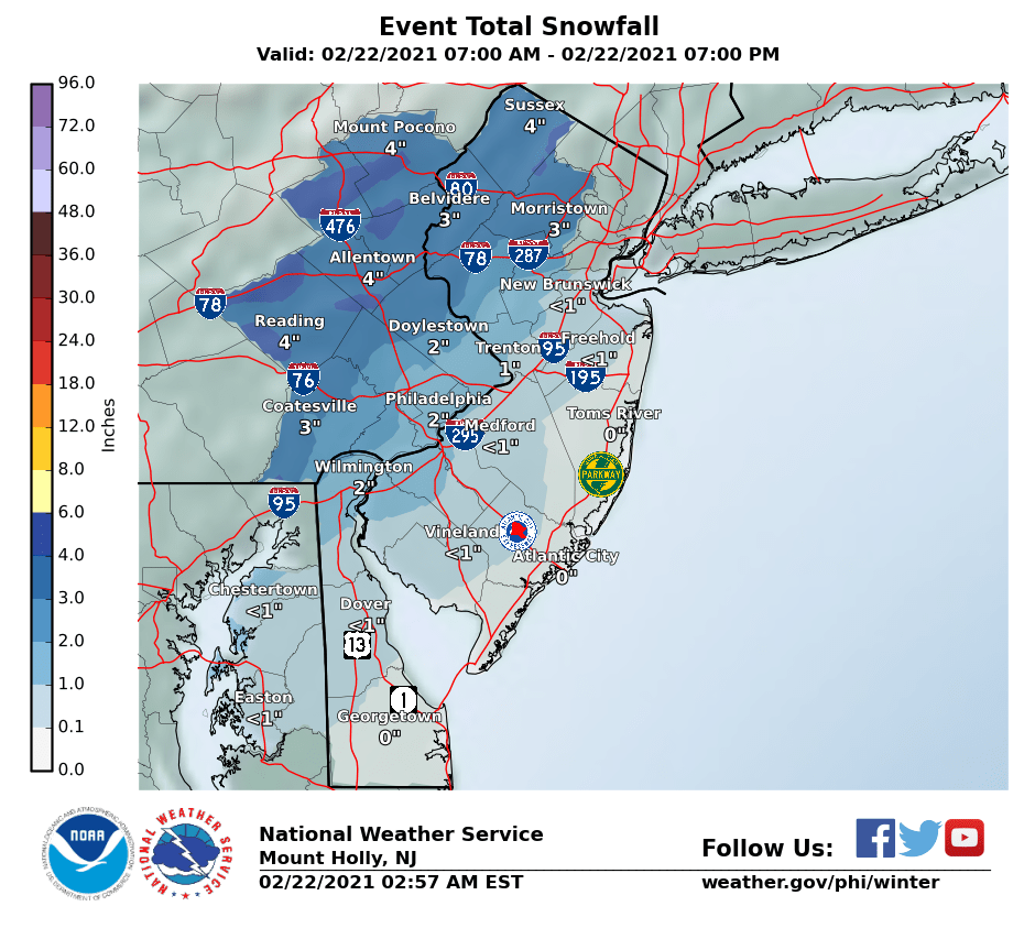
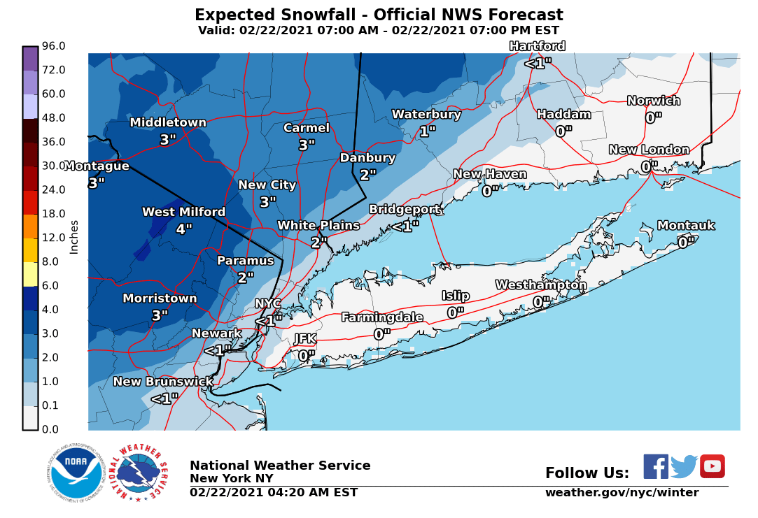
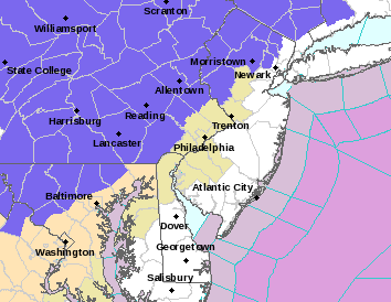
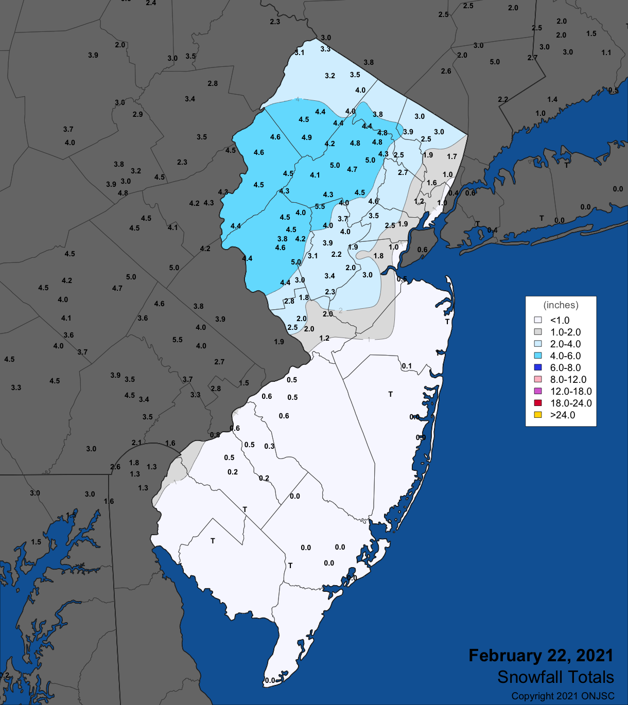
And the NWS -Philly overnight added Hunterdon and Morris counties to the advisory list for 2-4" of snow this morning/early afternoon, while the NWS-NYC added Passaic, N. Bergen, W. Essex and the Hudson Valley to the advisory list, also for 2-4" of snow. In addition, the next tier of counties SE of there on the western side of the 95 corridor (Philadelphia, SE Montco, SE Bucks, Mercer and Somerset) are forecast to get 1-2" with up to 3" in the NW parts of those counties. Up to an inch is forecast from about NB through NYC, along 95 (less than SW of NB to Phillly, which has 1-2" forecast).

With this event being a quick hitter with up to about 0.5" of liquid equivalent falling in maybe 6-7 hours from mid-morning through mid/late-afternoon, buts potential is quite high especially along and just NW of 95, where temps will be borderline for accumulating snow (33-35F) during late Feb with the higher sun angle, so snow may only accumulate on the snow on the ground at 32F, with little accumulating on paved surfaces - it would be easy for 95 and just NW to be almost all rain, while it would also be easy for the 95-corridor to be mostly snow with a few inches falling on colder surfaces. Tough forecast with a steep gradient in snowfall from SE to NW. Further NW for the advisory counties, snowfall rates should be enough for impacts on travel.

https://www.weather.gov/phi/
https://www.33andrain.com/topic/2029-february-22-2021-nw-burbs-snow-thump/page/3/

TKAiUzN.png
C91tuTQ.png


NOP9JZI.png

Finally found a snowfall map for this event, as the NWS only sometimes issues them, since the post-storm snowfall maps are considered an "experimental product." Anyway, looks like the NWS did ok with this one.

snow_20210222.png
 
ADVERTISEMENT