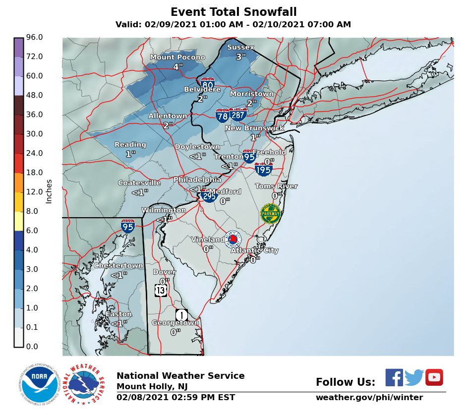
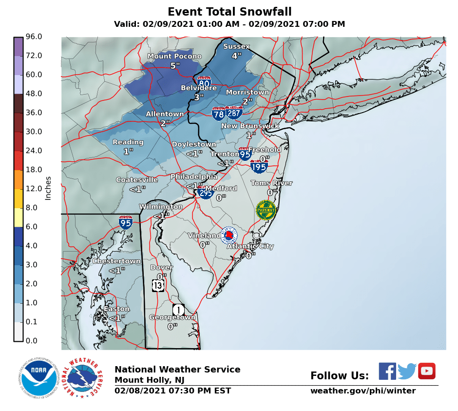
NWS just issued advisories for Sussex, the Poconos, W. Passaic, N. Bergen and the Hudson Valley for 2-4" of snow, largely north of about I-80 tomorrow early morning into the early afternoon. The 1" line is from about Frenchtown to Carteret, but as many pros have been saying, there will be very cold air in place at the start of this event (mid-20s for the 95 corridor even), so having a fairly weak system approaching from the west (this is not a coastal storm, but is a SW flow event or SWFE as are the possible systems on Thurs and Fri) dislodging that cold air will not be simple and this event could overperform if the warm air doesn't come in and change the snow to rain south of about 78 and it's possible we could see 1-2" between 276/195 and 78 before any change to rain.
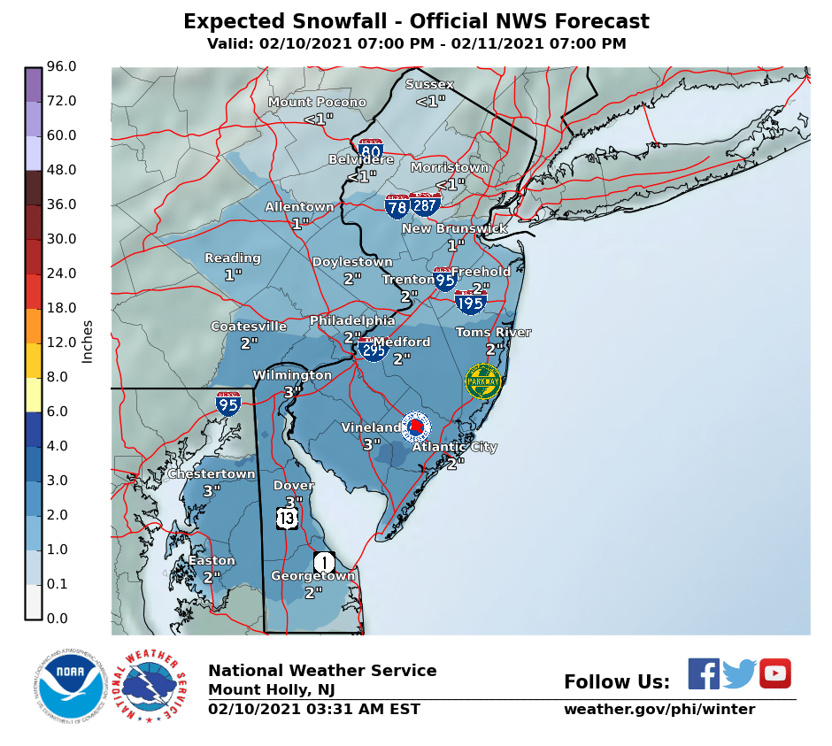
For the late Weds through Thursday morning event, which is another low approaching from the west (not a coastal) that's trending more minor for areas N of 276/195 with models showing a more general 1-3" north of that line and 2-4" south of that line, although it's still possible this could be a moderate 2-4" event up to 78. With very cold air in place, precip type is likely to be snow - the issue is suppression from the confluence from the very cold air to our north keeping most of the snow to the south.
Hopefully we'll start to see more consensus from the models on this by tonight. And the possible Friday event, which is another low approaching from the west (not a coastal) is all over the place from whiffs to a minor/moderate event, but this is not expected to be even a significant storm either - however, with the two systems close in time to each other, it's possible the combination of the two could result in a significant amount of snow for some (3-6") from late Wed through Fri morning. A stronger coastal storm is possible for Sunday, but way too far out to speculate on. Nice write-up on all of these from the NWS-Philly below.
https://forecast.weather.gov/produc...&format=CI&version=1&glossary=1&highlight=off
National Weather Service Mount Holly NJ
352 PM EST Mon Feb 8 2021
NEAR TERM /THROUGH TUESDAY/...
Tonight...
Fair weather will continue into the early overnight as
high pressure pushes further away from the region. Clear skies early
with increasing clouds by midnight. Low temperatures will drop into
the teens up north and the low/mid 20s in most other areas. Winds
will remain light. After midnight,
moisture from the next system
will arrive across the area.
Pops increase from W to E late with
slight
chc pops S/E and
likely pops N/W by
dawn. P-type will be snow
in most areas by 12Z. There could be a little freezing rain across
the rural areas W of Philadelphia by
dawn, but confid in this is not
great
attm so we`ll just mention slight
chc in the grids. An
advisory will go into effect for Carbon and Monroe counties of PA
and Sussex county NJ overnight with the
accums expected to be
some 3 to 4 inches through Tuesday.
Tuesday...Snow will continue to overspread the area early before a
change to rain from S to N occurs later in the morning across most
of NJ and Delmarva. The N/W more areas will remain cold enough for
snow all day.
Accums will be mostly 2-4 inches for the Lehigh
Valley, Berks county PA and much of nrn NJ. Lighter amounts are
expected for the
metro Philadelphia areas and central NJ. The advisory
will continue into the afternoon for the nrn areas. High temperatures
Tue will reach the upper 20s to low 30s for the nrn areas and low to
mid 40s for
srn NJ and much of Delmarva.
&&
SHORT TERM /TUESDAY NIGHT THROUGH THURSDAY/...
The
active weather pattern continues mid to late week. To begin
the period, low pressure moves off the coast Tuesday night
bringing a cold
front through with a transient high briefly
moving in into early Wednesday. However by late Wednesday, an
upper level disturbance will be approaching as it`s ejected
eastward from the broad polar
vortex over central Canada. This
will lead to increasing cloudiness with a chance of light snow
or a rain/snow mix by late day over eastern PA as it arrives
from the west. Highs range from the 20s north to the 30s over SE
PA through much of central/southern NJ, and Delmarva.
Wednesday night into Thursday, aformentioned disturbance moves
east interacting with the strong west/east oriented baroclinic
near the mid Atlantic. This will result in a weak area of
surface low pressure developing near Virginia with an inverted
trough extending north towards the area. Trend has been weaker
and farther south with this system which makes sense given that
this is more of a
stable type of wave near the periphery of an
arctic
air mass. As a result, our forecast has trended colder
and more towards snow meaning this could still be a fairly
impactful winter system. In terms of the details, snow moves in
west to east Wednesday night with some rain or mixed
precipitation still possible over southern areas over southern
Delmarva into far southern NJ. This could include a bit of sleet
or freezing rain though the threat for this looks lower now
compared to previous thinking. Overall, precipitation intensity
looks to be light to possibly moderate at times but this will
depend on the strength and track of the system and there is
still some uncertainty on this.
Snow looks to continue across much of the area through the
first part of Thursday with mixing continuing to be possible in
far southern areas through southern Delmarva into southern NJ.
However it should be noted if this trend south continues, even
these area could see mostly snow.
By late day Thursday there may be a lull in precipitation
before a second
impulse could bring another round of
precipitation Thursday night into Friday. Our current forecast
is for a general 1 to 4 inches of snow across much of the area
by late Thursday but again there remains uncertainty on this and
on where the heaviest amounts may occur. &&
.LONG TERM /THURSDAY NIGHT THROUGH MONDAY/...
Active winter pattern continues through the weekend as the
broad polar
vortex over central Canada looks to gradually drift
eastward. As this occurs, it will result in additional chances
for precipitation with temperatures generally running below
average. That said, the pattern is quite volatile and there has
been a lot of inconsistency in the long range forecast models so
confidence in the specific forecast details is below average at
this time.
In terms of how the forecast breaks down, following the round
of precipitation that moves through Wednesday night into
Thursday another wave looks to move through along the wavering
front to our south Thursday night into Friday. This has the
potential to bring additional accumulating snow in another round
of light to potentially moderate precipitation but confidence
is still low at this time as it will again depend on the
strength of the wave and where exactly the
baroclinic zone sets
up.
Following the late week system there looks to be another
reprieve by late Friday into early Saturday. However as the
upper level low moves from central Canada towards the Great
Lakes this looks to eventually initiate another low pressure
system over the east that has the potential to be stronger and
tap into richer
moisture from the south as the pattern becomes
more amplified. Depending on the track the system takes this
could bring more snow to the region or snow changing to rain by
late Saturday into Sunday.