ADVERTISEMENT

OT: Official Hurricane Irma Thread

RU4Real

Legend
Jul 25, 2001
50,878
29,944
113
Tropical Storm Irma formed today west of the Cabo Verde Islands and is forecast to quickly become a hurricane - perhaps as soon as tomorrow.

It's a well-formed storm, for its age, and I've got a hunch it gets pretty big. I feel in my old bones that this might be one to watch.

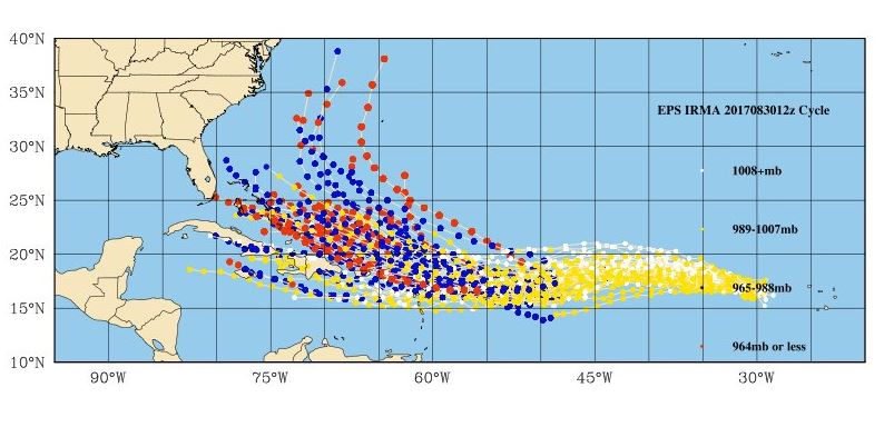
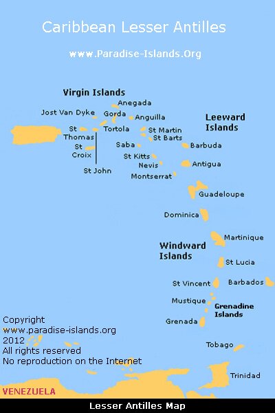
Right now the forecast track takes it WNW, then WSW, toward the Lesser Antilles. The long-range models show a scattering of recurve tracks, up into the western Atlantic off the U.S. coast.

So place your bets: Fish Storm, Gulf Storm, SE US or Other.
 
At this point throwing a dart onto a map would be as useful as a model forecast...
 
At this point throwing a dart onto a map would be as useful as a model forecast...

The short-term, as in 5 day, forecasts are reasonably accurate. I wouldn't expect to see much deviation over 120 hours from what the NHC is showing in their forecast cone.

Beyond that, there's definitely much more track uncertainty.

Hence the thread.
 
  • Like
Reactions: RU22
The short-term, as in 5 day, forecasts are reasonably accurate. I wouldn't expect to see much deviation over 120 hours from what the NHC is showing in their forecast cone.

Beyond that, there's definitely much more track uncertainty.

Hence the thread.

I meant beyond 5 days...that forecast has been flip flopping for the past 3 days...but it's good BS fodder for the WC drama queens
 
I meant beyond 5 days...that forecast has been flip flopping for the past 3 days...but it's good BS fodder for the WC drama queens

You're talking about something completely different. There was no "beyond 5 days" forecast for TS Irma, which was only designated a few hours ago.
 
At this point throwing a dart onto a map would be as useful as a model forecast...
Depends how good a dart thrower you are. If what you mean is that it may as well be random.. you are wrong. We know these storms move in regular patters with variability.. but it is certain it is not going to move south east from where it is now.

And models have been getting better every year as the ability to collect data and compare historic tracks has increased year by year. One day, perhaps soon.. the models will be more right then wrong.. regularly.
 
Last edited:
Depends how good a dart thrower you are. If what you mean is that it may as well be random.. you are wrong. We know these storms move in regular patters with variability.. but it is certain it is not going to move south east from where it is now.

And models have been getting better every year as the ability to collect variables and compare historic tracks has increased year by year. One day, perhaps soon.. the models will be more right then wrong.. regularly.

The CV storms have been predictable, in a general sense, for a very very long time. If they blow through the Lesser Antilles into the southern Caribbean they generally wind up in the gulf. If they cut north on initial contact with the western Atlantic, toward PR, DR, Cuba, et al, then they'll usually wind up on the western Atlantic recurve path, affecting Florida or the Bahamas or, in some cases, Bermuda or the OBX.

That's what makes Irma an interesting storm - there's a good amount of model consensus that it gets forced southward by the Bermuda High, but the extent of that suppression will be interesting to watch in the 7-10 day range.
 
My bet - RU#'s gets ridiculously excited, posters make fun of him, he goes cries to an admin and then denies it.
:)

For those actually interested in this storm, below are the models run out 10+ days, taken from a post on AmericanWx. Obviously, the uncertainty on track this far our is huge (assuming it survives the next 3-4 days of unfavorable conditions).

If folks really want to keep an eye on this storm, the American thread is probably the best place to do so. As I said in my post this morning on Irma, it's still way, way, way too early to worry about, but it is worth watching. The post, below, from a very good met on AmericanWx is worth keeping in mind - the most important element in the long term track is likely whether the trough that exits the east coast in 7-8 days is too early to "capture" Irma and curve her out to sea, leaving her to move more westerly towards Florida.

https://www.americanwx.com/bb/topic/50217-tropical-storm-irma/?page=3

Timing is off by 24-48 hrs for a capture. Base of the trough is off the east coast before Irma makes it past Bermuda's longitude. Euro shows this as well.
With the strength of the ridge over the western Atlantic and the missed timing of the deep trough over the eastern CONUS around day 9, I'm leaning that Irma heads west into Fla or the Keys.

Plenty of time obviously, but based on current guidance I don't see her getting picked up around day 9--I need to see big timing changes on guidance first. And if that's the case, that ridge is taking her west.


Capture2.jpg.28fda2684d1738b416d52164e8fe5934.jpg
 
Last edited by a moderator:
@DJ Spanky laid that myth to rest awhile ago. You need some new material. So, where's your criticism of 4Real for starting a thread ridiculously early on a tropical system?

For those actually interested in this storm, below are the models run out 10+ days, taken from a post on AmericanWx. Obviously, the uncertainty on track this far our is huge (assuming it survives the next 3-4 days of unfavorable conditions).

If folks really want to keep an eye on this storm, the American thread is probably the best place to do so. As I said in my post this morning on Irma, it's still way, way, way too early to worry about, but it is worth watching. The post, below, from a very good met on AmericanWx is worth keeping in mind - the most important element in the long term track is likely whether the trough that exits the east coast in 7-8 days is too early to "capture" Irma and curve her out to sea, leaving her to move more westerly towards Florida.

https://www.americanwx.com/bb/topic/50217-tropical-storm-irma/?page=3

Timing is off by 24-48 hrs for a capture. Base of the trough is off the east coast before Irma makes it past Bermuda's longitude. Euro shows this as well.
With the strength of the ridge over the western Atlantic and the missed timing of the deep trough over the eastern CONUS around day 9, I'm leaning that Irma heads west into Fla or the Keys.

Plenty of time obviously, but based on current guidance I don't see her getting picked up around day 9--I need to see big timing changes on guidance first. And if that's the case, that ridge is taking her west.


Capture2.jpg.28fda2684d1738b416d52164e8fe5934.jpg

Thanks for the graphic. Notice that the model spread pretty much illustrates my 3 prime scenarios in the OP - go low into the gulf, go a little higher into the southeast coast or head for the goalposts of Bermuda and OBX.

It really is remarkable, to me, that so many storms, year after year, do basically the same things.

p.s. I think this is going to be a hell of a storm.
 
Last edited:
Thanks for the graphic. Notice that the model spread pretty much illustrates my 3 prime scenarios in the OP - go low into the gulf, go a little higher into the southeast coast or head for the goalposts of Bermuda and OBX.

It really is remarkable, to me, that so many storms, year after year, do basically the same things.
They follow the trade winds.. roughly. Historically speaking, those patterns were what the Atlantic age of sail trade ships counted on for hundreds of years. If wind patterns were less predictable or different they might have come up with other trade patterns.

1009514mid_360.jpg
 
  • Like
Reactions: KevH and GORU2014
The Weather Channel was talking about this storm this morning. i fear it will be a bad one.
 
Thanks for the graphic. Notice that the model spread pretty much illustrates my 3 prime scenarios in the OP - go low into the gulf, go a little higher into the southeast coast or head for the goalposts of Bermuda and OBX.

It really is remarkable, to me, that so many storms, year after year, do basically the same things.

p.s. I think this is going to be a hell of a storm.

My gut tells me this could be pretty serious, also. Storm reminds me of Ike in some ways, as both formed almost due west of the Cape Verde Islands and it looks like the first week or so of Irma will be similar to Ike. For people who don't recall, Ike spanked the Lesser Antilles, then crushed Haiti and Cuba, losing a lot of strength, and then crossed the GOM hitting the TX coast at Galveston as a Cat 2 (and hitting it and Houston hard, but not lingering, like Harvery for flooding rains).

After that, who knows, but as DT/WxRisk always says, the key benchmark will be where does Irma pass Puerto Rico. South of PR and Irma will very likely hit the Caribbean and possibly the Gulf; north of PR and Florida and/or the US east coast come into play (as does staying offshore completely).
 
Of course, it can hit this area, but that's extremely unlikely and anybody who tells you they know where Irma is going to go beyond 6-7 days is full of shite - and if Irma is to come here that'll be in the 13-15 day range, which is way out in the future.

The more recent model runs are favoring an east coast storm with pretty good intensity.

Like we said, it bears watching, for sure.
 
The more recent model runs are favoring an east coast storm with pretty good intensity.

Like we said, it bears watching, for sure.
East Coast = more Florida or more Carolinas?

I know it's early but I like to know these things.
 
East Coast = more Florida or more Carolinas?

I know it's early but I like to know these things.

The models are spread. The GFS runs the coast and landfalls in Maine (not terribly likely) while the Euro is more southern and hits the Carolina capes before moving up the coast (similar to an Irene solution, but a much stronger storm).
 
East Coast = more Florida or more Carolinas?

I know it's early but I like to know these things.

Way too early to "know" anything about Irma's eventual path 10+ days from now, which is when it would be in the vicinity of maybe Cuba/Bahamas/South Florida (if it takes that kind of track). And then it's another few days before it could theoretically make it into the Gulf or turn up the east coast to possibly affect the Carolinas to New England. Literally impossible to know if it's going to go into the GOM or hit the east coast or miss the east coast at this point.

Having said all that, it's certainly concerning that the models, in the long range, are showing impacts anywhere from the Keys to New England, including the Euro, which has been the best model for hurricane tracks for many years. If the track still shows US impacts in 3-5 days, then it's time to start worrying.
 
Irma is too far east for recon flights, but the very latest satellite data is showing a 987mb 75 mph hurricane. The next NHC update is at 11AM.
 
Way too early to "know" anything about Irma's eventual path 10+ days from now, which is when it would be in the vicinity of maybe Cuba/Bahamas/South Florida (if it takes that kind of track). And then it's another few days before it could theoretically make it into the Gulf or turn up the east coast to possibly affect the Carolinas to New England. Literally impossible to know if it's going to go into the GOM or hit the east coast or miss the east coast at this point.

Having said all that, it's certainly concerning that the models, in the long range, are showing impacts anywhere from the Keys to New England, including the Euro, which has been the best model for hurricane tracks for many years. If the track still shows US impacts in 3-5 days, then it's time to start worrying.
I know. It is a stochastic sort of world and we're just a part of it.

The thread title includes "place your bets" so I'm not holding anybody to anything.
 
I know. It is a stochastic sort of world and we're just a part of it.

The thread title includes "place your bets" so I'm not holding anybody to anything.

I took the "place your bets" out of the thread title. Irma could have major impacts based on early modeling, so I thought it best to trim the levity a bit.
 
WAG (wild-assed guess) Disney look out! But my gut says it will be nothing.. we are all just alarmed, rightly, by Harvey.
 
I know. It is a stochastic sort of world and we're just a part of it.

The thread title includes "place your bets" so I'm not holding anybody to anything.

Since you know the word, which most don't, this is likely aimed at others. While weather certainly has some stochastic (random) elements and while numerical weather predictions - especially ensemble forecasts where initial and boundary condiitons are varied randomly about the mean - utilize stochastic inputs, chaos is a far more important element in weather forecasting.

Chaos, or the uncertainty that arises from small errors in initial and boundary conditions models for weather simulation use, is the main reason weather forecasts are simply impossible to get right beyond maybe 7-8 days. The small errors propagate and get much larger, in time, as the models run further out in time.

Often known better as the "Butterfly Effect" a term coined by Lorenz back in the early 60s when he first published his work on Chaos Theory - he showed that these small errors can propogate so much that a butterfly flapping its wings at t=0 can impact the outcome of a tornado weeks later for deterministic, non-linear systems, like the weather. Kinda cool stuff...

https://en.wikipedia.org/wiki/Butterfly_effect
 
  • Like
Reactions: RuSnp
Just remember, if you pass gas in the wrong section of the stadium Friday night.....
 
LOOKS LIKE WE MAY HAVE cat 4

nhc:
NHC forecast shows an
extremely dangerous category 4 hurricane next week, similar to the
solutions provided by the HWRF and the ECMWF models. The intensity
forecast is raised considerably from the previous one due to initial
trends, and is on the high end of the guidance at long range.
 
The initial NHC advisory on Hurricane Irma is that it's a Cat 2, pretty much right out of the box. Strengthening to Cat 4 is forecasted.

Somebody is going to see one hell of a storm.
 
The initial NHC advisory on Hurricane Irma is that it's a Cat 2, pretty much right out of the box. Strengthening to Cat 4 is forecasted.

Somebody is going to see one hell of a storm.


Interesting tid-bit. Irma is the name that was selected by the WMO to replace Irene in the current naming cycle....
 
Last edited:
The initial NHC advisory on Hurricane Irma is that it's a Cat 2, pretty much right out of the box. Strengthening to Cat 4 is forecasted.

Somebody is going to see one hell of a storm.
The current track at 5 days puts a Cat 4 storm due east of the center of the Lesser Antilles and the storm will only take about 2 more days to reach those islands. With a WNW shift after day 5 likely, the northernmost of those islands, the Leeward Islands (like the Virgin Islands, Guadaloupe, Antigua, etc.) and then Puerto Rico are under the gun for a potentially devastating storm. Nowhere near a given that it hits in that region, but 6-7 days out is close enough for people to start preparing now, especially since evacuation isn't as simple as getting in one's car and driving a few hundred miles.

21230820_10212053684771449_3410659261775739879_n.jpg


lesser-antilles-map.jpg
 
Wrong type of storm and high risk of mildly irritating the weather buffs due to premature posting, but...

 
The latest Euro takes Irma just south of the Keys in 10 days, shooting the gap into the GoM.

The GFS went the other way on its previous run, hooking up into the Maritimes.
 
I'd only value one of the opinions you listed, WPK's

Classic troll answer, as if anyone cares about your opinion on anything related to science. The correct answer, which WPK and any other met would tell you, is that you shouldn't trust anyone's opinion on where a hurricane will be 10+ days out.

WPK knows more about meteorology than I likely ever will, but I'm willing to wager I know at least as much about chaos theory and deterministic non-linear systems and numerical analysis of such systems (such as the weather) as most meteorologists (can't be sure about WPK's knowledge on that, though).
 
ADVERTISEMENT