ADVERTISEMENT

OT: Potential Winter Storm on 3/7-8

RU848789

Legend
Gold Member
Jul 27, 2001
60,505
39,087
113
Metuchen, NJ
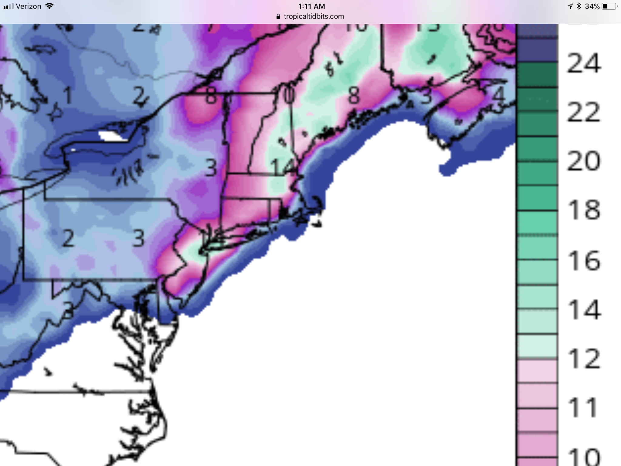
Looks like a busy week+ ahead for tracking potential winter storms, as I had mentioned about a week ago. Today's 12Z GFS and CMC continue to show significant snow on 3/7-8 at least for CNJ, NNJ, NYC/LI, NE PA, and inland and the Euro now is even more bullish. And most of the pros are wired for this one given the potential of the pattern with the -NAO blocking high near Greenland, which should keep the storm from going inland, as well as colder air in place at the start (vs. yesterday), which can only help (but can't overcome a bad track should that occur).

Have also heard the UK also looks decent, especially for NW areas. Below is a peek at 3 of the main global models, just to give a flavor of the potential here. Don't take this as anywhere near a forecast, though, as a ton can change this far out. And there is significant potential for a winter storm around 3/12.

https://www.33andrain.com/topic/820-march-7-8-redemption-threat/?page=4&tab=comments#comment-62405

28576456_10213370858379966_2653886491498905600_n.jpg


28575601_10213370874660373_453909783271964672_n.jpg


28576335_10213370882900579_5594995145641558016_n.jpg
 
You used the term "decent" in the last (and FINAL! - LOL) post of the previous thread to describe this next one.

Can you expand on that? As your "decent" might have the same meaning as the rest of us.
 
Last edited:
Mt Holly is not as enthused as the weenies...mentioning two scenerios..and yes while they say things are leaning to the heavier scenerio...precip type is uncertain as the storm would have to generate its own cold air

The active part of the period with yet another storm system
threatening to affect the Mid-Atlantic region Tuesday night into
Wednesday. Similar to the evolution of yesterday`s storm
system, a primary low is expected to track eastward across the
Midwest/Ohio Valley, then redevelop just off the Mid-Atlantic
coast. Models appear to be clustering into two general scenarios
with increasing support for the second scenario:

(1) A progressive/flatter solution that would favor the coastal low
to track faster out to sea as phasing with a trailing northern
stream shortwave trough over the Great Lakes is limited.

(2) An amplified system that supports steady deepening of the
coastal low as it phases with the upstream trough. Currently, this
camp of models do not indicate secondary cyclogenesis to be as
intense as the recent storm but still formidable with MSLP lowering
to around 995 mb off the NJ coast by midday Wednesday and around 985
mb near Cape Cod by midnight Thursday.

In scenario (1), the large-scale dynamics would be weaker with the
bulk of the lift from the coastal low remaining offshore. A brief
period of light precip (rain/snow) could occur but impacts would be
minimal. In the latter scenario, Atlantic moisture would be advected
inland and heavier precip could expand westward due to the phasing.
The low track would be favorable for late season snow, especially
away from the coast. However, without a strong high anchored to our
north, the cold air would have to be generated from the coastal
storm itself via dynamical cooling, especially along and south/east
of I-95 where boundary-layer temperatures will initially be warm (in
a similar fashion to what we saw this with yesterday`s storm).
Given (1) the growing support with today`s 12Z runs for a moderate
to heavy precip (rain/snow) event and (2) the ongoing restoration
efforts following yesterday`s storm that will likely continue for
the next several days across the hardest hit areas, we want to be
proactive with getting the message out on another potential
impactful event even if the details are still unclear this far out.

You left out the opening paragraph, below, which certainly shows some enthusiasm to me, at least for a substantial winter storm that will likely affect the area and which has a good chance of bringing snow to some or even much of their forecast area. My guess is the 95-corridor will be the battleground, but this won't be as intense of a storm, so precip and precip types will likely be more dependent on track and not intensity/banding vs. yesterday's storm, which was very unusual in that regard.

What I mean is rather than fairly random areas that "shouldn't" be snowier getting more snow simply because of high intensity bands cooling the column in that area (like SW of Philly and Monmouth County shouldn't normally get more snow than Somerset/Middlesex Counties when temps are an issue), this will likely be more typical, where there will be a rain-snow line somewhere that will move during the storm, but in which it'll be snow to the NW of the line and rain to the SE of the line. In this scenario if the line, for example, is the NJ TPK (and it doesn't move - which won't actually happen, but I'm just being illustrative), Ewing, Somerville, and Scotch Plains will be all snow, the TPK will be a mix and Fort Dix, Englishtown, and Matawan will be all rain.

LONG TERM /SUNDAY NIGHT THROUGH SATURDAY/...
There is growing support for another coastal storm to affect the
region Tuesday night and Wednesday, possibly bringing plowable
snowfall to portions of the forecast area...
 
This is setting up to be a more widespread storm in NJ. I know RU4REAL and BAC will be in this thread Sunday to tell us why this will be nothing. But here is GFS snow map from 11pm. Waiting for Euro

GFS:

8stKlh2.png
 
GFS, CMC and UK were all decent hits, but with mixing and snow melting on contact issues for 95 and the coast, while the Euro was somewhat offshore with most of the snow from 95 and eastward, but less mixing due to the more offshore track. Still too much uncertainty to make forecasts from, but the potential is certainly there for a modest to significant snow for most, as is the potential for a wetter than white event for 95 and the coast or a more out to sea solution, which just mostly hits 95 to the coast with light to moderate snow. And with some/most of the precip falling during daylight hours with surface temps at or a bit above 32F for many, melting will be an issue.
 
Last edited:
The upper Manasquan River is way above normal by Allaire State Park. Our usual mountain bike path was an interesting ride yesterday, with a footbridge washed away and the river way above its usual banks. More rain in a short period of time is going to make that worse. @RU848789 would have liked seeing patches of snow in the woods of Allaire.
 
So if all those models are showing 6-14 inches in the NYC area i should count on what, a few mood flakes and rain?
Two were showing that much yesterday out of 5 main global models and only 1 was showing that much last night, so not sure what your point is. There's potential for significant snow, but just as much chance of some to mostly rain for 95 and the coast. Still too much uncertainty at this range. Some people have trouble with the large uncertainty in the models, while I'm just amazed we even have anywhere near the accuracy we have, especially as compared to 20 years ago.
 
How come the snow maps stopped being posted when they started to show less

Also cmc and euro moving things east....good luck with the unreliable gfs
 
  • Like
Reactions: T2Kplus10
How come the snow maps stopped being posted when they started to show less

Also cmc and euro moving things east....good luck with the unreliable gfs

Seriously? One, on Sundays I play soccer in the morning, then usually we do something with our son, so just getting back. And two, I rarely post model maps here, as I think they can be misleading, especially if cherry-picked to highlight a particular outcome, which is your specialty - look at today, you posted the two non-snowy outcomes and didn't post the snowy one at 12Z and now with the 2 18Z models showing major snow, you somehow neglected to post those maps (although you did at least mention them). I posted maps for the first post in the thread to simply "give a flavor of the potential here," as I said in that post (and I posted all of the ones I had access to - I didn't leave any out).

So now, rather than posting the two main 18Z models (GFS and NAM; Euro and CMC don't run at 18Z) which are really snowy, I'll just post the NWS snowfall maps, which were made before the 18Z runs came out. I would imagine those maps will get snowier if the 0Z models continue showing more snow than their forecast. We'll see, but igoring the potential in this pattern is foolhardy. This storm has much more model support and pattern support for snow in the 95 corridor and coast than Friday's did - Friday's was a more powerful storm, but it relied on perfect dynamics to get some late snow in some places that got those dynamics. But we're still almost 3 days out, so a wetter solution and a more out to sea solution are still possible.

28685107_10213379502436062_8456996893103226880_n.jpg


28577846_10213379505516139_2222474335333908480_n.jpg
 
Last edited:
I have a Wednesday night flight out of JFK, should I be concerned it gets canceled?
 
I have a Wednesday night flight out of JFK, should I be concerned it gets canceled?
Yes, you should as the height of the storm will be Weds afternoon and evening and if the ceiling of this storm is realized (8-14"), then I would think some flights will be cancelled. While this storm has much more model support and pattern support for snow in the 95 corridor and coast than Friday's did, this storm will also be considerably less powerful than Friday's. Friday's storm produced 2-4" of liquid equivalent for a huge area, which translated to 2-3 feet of snow for locations in far NW areas that got all snow and obviously 1-2" of rain and 4-10" of snow in some locations south of 78, where perfect dynamics led to some late snow in some places.

Friday's storm also had incredible winds and minor to moderate coastal flooding in our area (and major flooding in New England as the storm was stronger up there) and major power outages due to snow, rain and wind - and of course huge levels of flight and train cancellations (this one won't have as many). This storm could have moderate to even major snowfall, but will have nowhere near the impact the other one did - except for snowfall in places that didn't get snow last time, if it pans out.
 
  • Like
Reactions: RU-Nation
Seriously? One, on Sundays I play soccer in the morning, then usually we do something with our son, so just getting back. And two, I rarely post model maps here, as I think they can be misleading, especially if cherry-picked to highlight a particular outcome, which is your specialty - look at today, you posted the two non-snowy outcomes and didn't post the snowy one at 12Z and now with the 2 18Z models showing major snow, you somehow neglected to post those maps (although you did at least mention them). I posted maps for the first post in the thread to simply "give a flavor of the potential here," as I said in that post (and I posted all of the ones I had access to - I didn't leave any out).

So now, rather than posting the two main 18Z models (GFS and NAM; Euro and CMC don't run at 18Z) which are really snowy, I'll just post the NWS snowfall maps, which were made before the 18Z runs came out. I would imagine those maps will get snowier if the 0Z models continue showing more snow than their forecast. We'll see, but igoring the potential in this pattern is foolhardy. This storm has much more model support and pattern support for snow in the 95 corridor and coast than Friday's did - Friday's was a more powerful storm, but it relied on perfect dynamics to get some late snow in some places that got those dynamics. But we're still almost 3 days out, so a wetter solution and a more out to sea solution are still possible.

28685107_10213379502436062_8456996893103226880_n.jpg


28577846_10213379505516139_2222474335333908480_n.jpg

wait...you led the thread by posting maps and then you said I cherry picked...lmfao...and hello I did post what 18z showed


Euro and CMC not showing snow....we toss

GFS which has been incredibly AWFUL with storms this year and widely panned shows snow...we hug

sure there is potential but there hardly model consensus on this and you know the nam is still out of range and as proven with the last storm often overdone

I for one am shocked Mt Holly snowmaps were so high initially. I think because they poo pooed the last event and while they were correct for alot of the area, for those areas that did get hit it was alot...so yeah figure they will probably err on the side of caution this time
 
Last edited:
  • Like
Reactions: T2Kplus10
I'll take 6-7" of snow if I can trade in 5 tide cycles of flooding like we had the last 3 days. I don't know why I worry now that I'm 8.5 feet off the ground. I guess I'm just programmed to worry about it.
 
wait...you led the thread by posting maps and then you said I cherry picked...lmfao...and hello I did post what 18z showed


Euro and CMC not showing snow....we toss

GFS which has been incredibly AWFUL with storms this year and widely panned shows snow...we hug

sure there is potential but there hardly model consensus on this and you know the nam is still out of range and as proven with the last storm often overdone

I for one am shocked Mt Holly snowmaps were so high initially. I think because they poo pooed the last event and while they were correct for alot of the area, for those areas that did get hit it was alot...so yeah figure they will probably err on the side of caution this time


I dont know what i enjoy more a good snow thread or the pro-snow anti-snow biotch slapping figts you guys have without fail. You two should get a room as Rodney once said.
 
wait...you led the thread by posting maps and then you said I cherry picked...lmfao...and hello I did post what 18z showed


Euro and CMC not showing snow....we toss

GFS which has been incredibly AWFUL with storms this year and widely panned shows snow...we hug

sure there is potential but there hardly model consensus on this and you know the nam is still out of range and as proven with the last storm often overdone

I for one am shocked Mt Holly snowmaps were so high initially. I think because they poo pooed the last event and while they were correct for alot of the area, for those areas that did get hit it was alot...so yeah figure they will probably err on the side of caution this time

You should seriously consider posting less in these threads if you're unable to keep up and you continue posting nonsense - it just derails the threads (or maybe I shouldn't respond to illustrate how wrong you are). Let's recap.
  • I posted all 3 major global models (don't have access to UK, so couldn't post the 4th) in the first post and clearly said I did it just to show the potential of the storm. No cherry picking, like you did this afternoon.
  • I rarely post model maps, as they can be misleading, but I do usually post discussions of model suites, whereas you tend to simply post model maps that are not snowy, like you did today by posting only the Euro and CMC, which were not snowy and not the GFS, which was snowy. Cherry picking.
  • Who said to "toss" the 12Z Euro and CMC? As I said above, I wasn't around all day to post, except for about a 20 minute period after soccer, before the CMC, GFS and Euro came out.
  • You said, "hello I did post what 18z showed," which is misleading, at best, as you mentioned they were snowier, but somehow neglected to post those model maps. I wonder why.
  • If I wanted to hype this event, I'd post the 18Z NAM and GFS, which both show a major snowstorm for almost the entire area - but I won't do that, as it's one partial suite of the models and could change tonight.
  • I've never "hugged" the GFS - in fact in the last storm, I was completely discounting its prediction of no snow south of 80 and you kept touting it, even on 33andrain and got dismissed. It performed horribly last storm, but not because it's always horrible, but because it's bad in situations where very accurate thermal profiles of the column are needed, like the last storm - this storm has a bit of that concern, but nowhere near the last storm, so the GFS shouldn't be embraced, per se, but also not tossed for this storm.
  • We completely agree on the NWS. They got burned for completely underplaying the snow threat, which I pointed out numerous times before and during the storm, and are making sure they don't have a major whiff again. Given their miss, but more importantly, the much better pattern and setup for snow for this storm, I think they're making the right call here and if tonight's runs continue with the 18Z runs, they might even nudge the snowfall amounts up an inch or two across the area to more like a 4-8" event. They won't go beyond that, IMO, until at least Monday night or Tuesday morning, should it look more like an 8-12" event.
 
So if we get snow out of this Wed/Thurs storm, is it more likely to stick than Friday's storm?
 
I said the 18z nam and gfs showed 6-12 inches...what more do you want..I dont have to write a full out analysis of that. Sorry I didnt know your thtead was for your analysis only and required your approval...I didnt post anything that wasnt true. I posted euro and cmc maps which were the most recent model map runs I saw...then I posted 18z runs showing 6-12 inches...me thinks you protest too much. I get you want to do a full analysis by yourself in these threads and control any narrative..just say that then
 
So if we get snow out of this Wed/Thurs storm, is it more likely to stick than Friday's storm?
Yes. Antecedent air is colder than Friday and there won't also be 1-2" of rain beforehand, both of which greatly increased melting rates vs. what we'll have on Wednesday - although there will still likely be a 1/4" per hour melting rate on Wednesday vs. the 3/8-1/2" estimated melting rate we had on Friday. In addition, more than half of the precip should fall after 4 pm, meaning the effect of the indirect sunlight will be minimal. But certainly from 9 am to 3 pm or so, we could see a fair amount of white rain, if we don't get good intensity.

The biggest key is probably this: if one gets a snowfall intensity for an hour or so that overcomes the melting rate (like 2/17 and Friday in places with very high intensity snowfall), then a layer of snow becomes established on the ground, which then means subsequent snowfall accumulates easily, since the snow is 32F, which means no melting from the surface, plus snow reflects 80-90% of the indirect sunlight (as opposed to grass which only reflects 25% of sunlight and asphalt, which only reflects 5% of sunlight.
 
watching this thread as i have an 8:05 out of EWR on Weds morning. Then a return flight landing at 9pm Thursday.......
 
I said the 18z nam and gfs showed 6-12 inches...what more do you want..I dont have to write a full out analysis of that. Sorry I didnt know your thtead was for your analysis only and required your approval...I didnt post anything that wasnt true. I posted euro and cmc maps which were the most recent model map runs I saw...then I posted 18z runs showing 6-12 inches...me thinks you protest too much. I get you want to do a full analysis by yourself in these threads and control any narrative..just say that then

You're missing my point completely. I'm not saying don't post, I'm saying stop regularly putting words in my mouth and implying I'm saying things that are not true, as I outlined above. You can certainly continue to say/imply I'm biased, even without being able to demonstrate it - there are no board rules against that - people do that all the time in threads. But I'd prefer you didn't and stick to posting info and data and it's certainly ok to disagree, as I'm not a me and have been wrong and will be again, but perhaps doing so without questioning my motivations would work better.

And you generally don't do that in the sports threads, so why do it here? I've posted many times giving you props on your generally level-headed and analytical hoops game summaries (and gave you and me and others a pass on in game threads, which are always going to be emotional) and bubble analyses and stuff and did again just last night. I don't recall you doing the same for my weather posts, like, for example, my call that the NWS should've put out a 1-3" forecast for most of NJ well before the storm - got props on that on the weather boards. I do know that these threads would certainly be better if we argued less, so I'm going to try to refrain from arguing motivations and sticking to data/info.
 
watching this thread as i have an 8:05 out of EWR on Weds morning. Then a return flight landing at 9pm Thursday.......
Likely you'll be ok to take off, although not a given, since snow could start as early as 5-6 am, but should be ok on the return flight...

Much appreciated

Now back to our regularly scheduled WWE throw down.......snow vs rain!
 
00Z NAM is out and boom! 12-18" from Philly to NYC and 50+ miles NW of that line, but a very steep gradient towards the NJ shore and from NYC to LI, as rain would be predominant at the immediate coast (with only a few inches of snow) as per this model run. Again, it's a model run, not a forecast, but it indicates the potential of this storm and the continuing and increasing likelihood of at least significant snow (6" or more) for all of the area. If you want to look at the map, see the thread, as I just posted it there (where every map of every run of every friggin' model gets posted, even the Korean and German models, which suck, lol).

Will edit this post to put the whole 0Z suite output in one place, as they come out...

https://www.33andrain.com/topic/820-march-7-8-redemption-threat/?page=28&tab=comments#comment-63124
 
ADVERTISEMENT