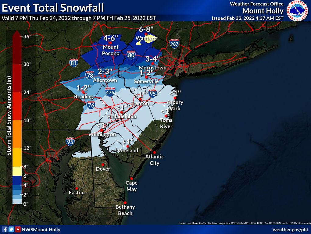
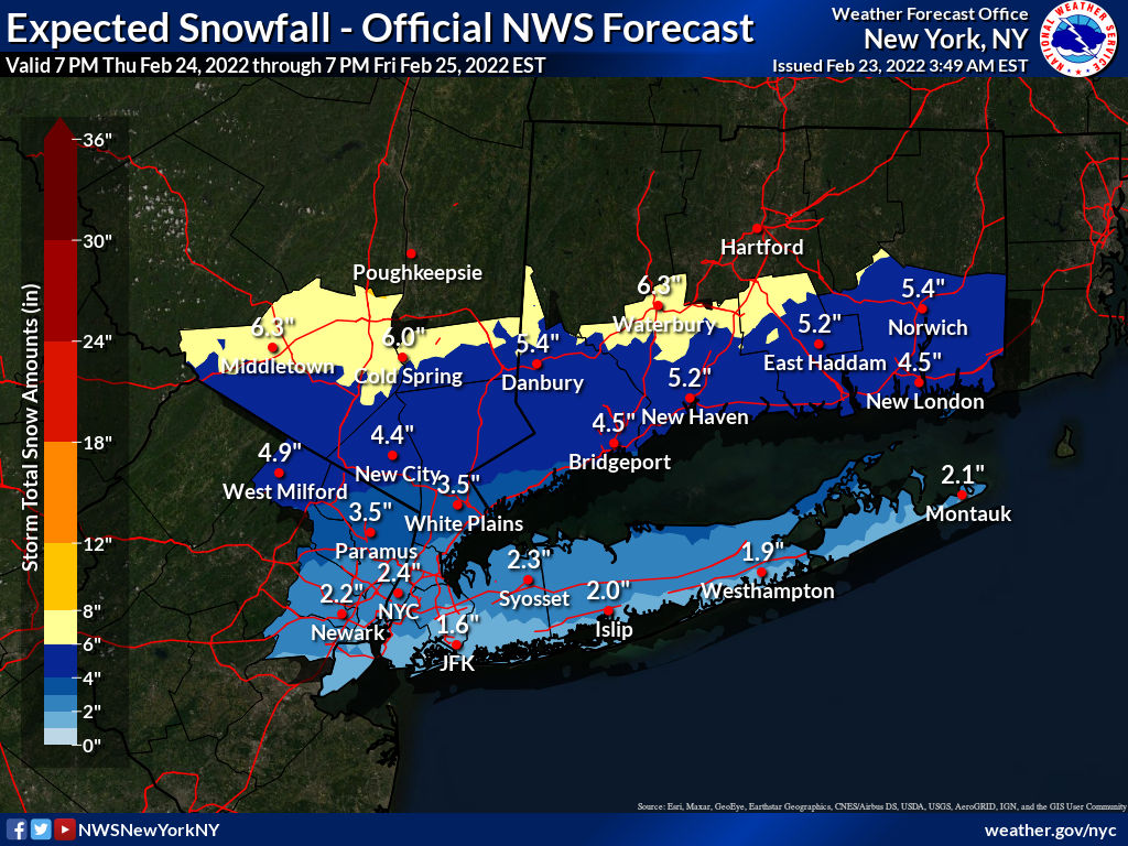
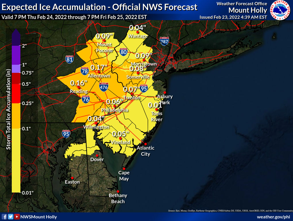
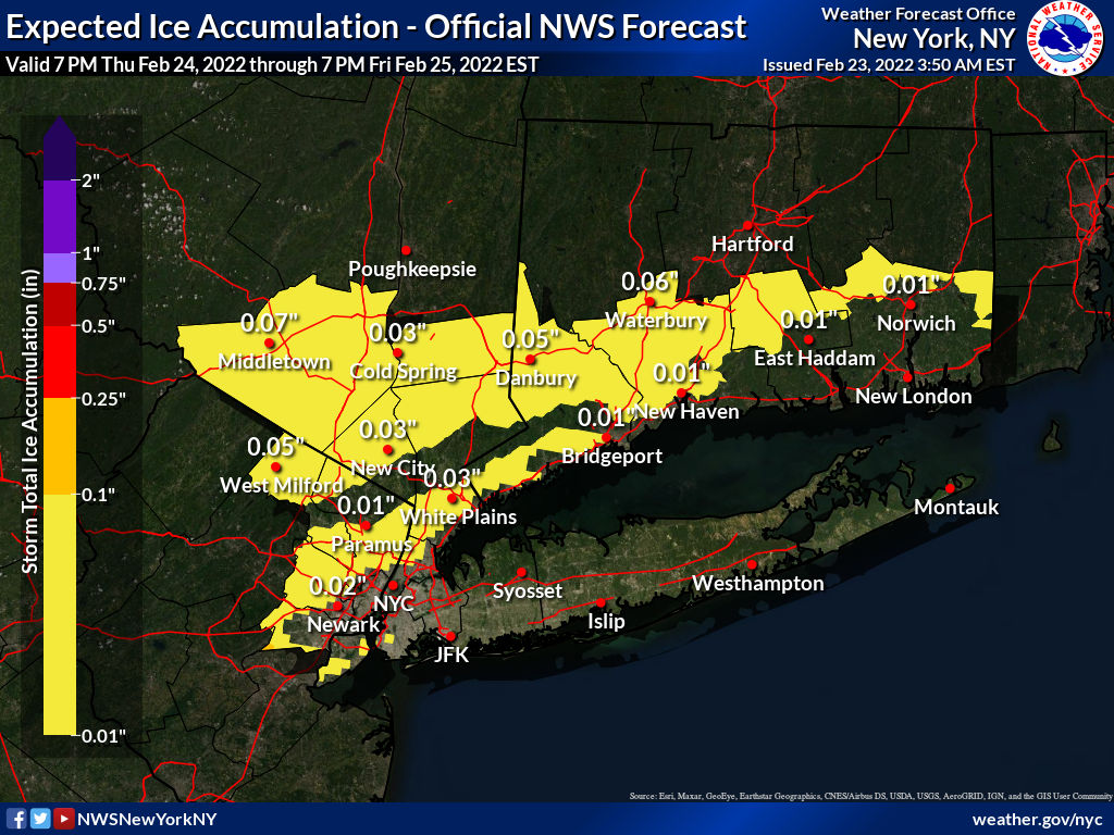
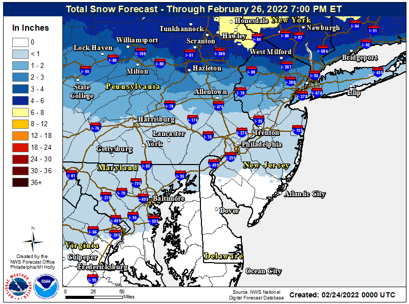
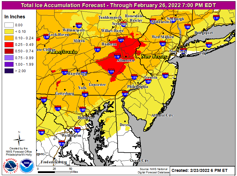
Just a heads up that we will have a winter storm coming through the area late Thursday night through Friday morning - this looks like a classic SWFE (southwest flow event) with a low approaching from the Ohio Valley bringing in moist warm air from our SW which will overrun cold air at the surface, producing snow at first, but then likely changing to sleet, then freezing rain, then plain rain for most, but since the primary low will likely transfer its energy to a coastal low, it won't get very warm like it does when a storm goes inland to our west.
So it looks like some snow/sleet to start along and north of 276/195, but probably changing to freezing rain (hopefully briefly) and then all rain (1-1.5" of total precip is likely) after a small accumulation from that line up to about 78 (with more near 78 than near 195, of course), while along and N of 78, there could be prolonged sleet and maybe some freezing rain, while N of 80 there could be several inches of snow/sleet and then some ice and maybe rain. Areas south of 276/195 and along the coast are likely to see almost all rain, unless the track of the storm ends up further south (possible); it's also possible the storm takes a more northerly track, leading to frozen precip perhaps being only along and north of 80. Like any mixed precip event, the uncertainty is off the charts this far out. This brings and end to the recent warm pattern...
https://forecast.weather.gov/produc...&format=CI&version=1&glossary=1&highlight=off
Area Forecast Discussion
National Weather Service Mount Holly NJ
1255 AM EST Tue Feb 22 2022
LONG TERM /WEDNESDAY THROUGH MONDAY/...
Thursday into Friday is when we expect the next system to affect the
region and confidence is growing there will be wintry precipitation
affecting at least parts of the area. In the big picture, the
forecast models are actually in fairly good overall agreement in the
idea of taking a primary low pressure system through the
Tennessee Valley north and east into western PA by Friday
morning with a secondary low developing off the coast. Meanwhile
arctic high pressure will remain banked to our north. This set
up is a favorable set up for all precip types to be in play as
warmer air moves in aloft while cold air damming keeps colder
air banked in near the surface. Given that this is still a few
days out and that minor differences in the temperatures both at
the surface and aloft could have a big affect on P-types there
remains uncertainty in the specific details of the forecast.
That said, latest indications are for an initial wave to try to
move in during the day Thursday affecting mainly the southern
half of the area (SE PA, southern NJ, Delmarva) with the threat
of some light precip. Temperatures will be mostly in the 30s
with a warm layer also aloft but colder air in a layer in
between so precip types look to be a mix of rain, sleet, and
snow. Any snow/ice accumulation through the day though should be
little to none though.
Heavier precipitation moves in Thursday evening lasting through the
overnight into Friday morning as the main system advances
north/east. Expect over much of Delmarva and southern NJ (especially
near the coast) that the precip will be mainly rain with a messy mix
farther north due to the warmer air aloft but colder air holding
tight in the low levels. Basically, near and north of the I-95
corridor over SE PA and Delmarva and near/north of I-195 in NJ
expect the potential for sleet and freezing rain mixed with snow.
This may not last too long near the southern periphery of this zone
but could be a more extended period of sleet and freezing rain
farther north towards the I-78 and I-80 corridors as the setup up is
pretty classic cold air damming. Low temperatures in these northern
areas will be mostly in the upper 20s to low 30s with mid 30s
farther south.
By Friday, the center of this complex system should make its closest
pass to the area in the morning with the secondary low taking over
and pulling away to the northeast by the afternoon. As such, expect
rain to continue into the morning for southern and central areas
(roughly south of I-78) with a wintry mix likely persisting farther
north. Precip winds down into the afternoon with winds shifting to
westerly and becoming gusty. In terms of expected totals of snow and
ice, it`s still a bit early to be confident on any numbers but it
does look at this point like the best chance for significant
snowfall should stay mostly just north of the area. However for
areas roughly near/north of I-78 at least some snow accumulation
looks to be possible along with the potential for a layer of ice
accretion. These details will continue to be refined over the next
couple days. There will be quite a variance in high temps for Friday
with highs near 60 over southern Delmarva where they will be into
the warm sector with 40s over SE PA into central NJ and only in the
30s over the southern Poconos and NW NJ.
For Saturday and Sunday...In the wake of the aformentioned storm,
cold high pressure builds in for Saturday with dry but chilly
conditions (highs mostly in the 30s) before the next trough starts
to dig into the eastern US by later Sunday. There could be a coastal
low that develops in association with this feature by later Sunday
into Sunday night but confidence on this is quite low at the current
time. By Monday, cold and blustery but mainly dry conditions build
in.
Last edited: