ADVERTISEMENT

OT: Significant Icing Risk for NW of 95/N of 78 Mon night/Tues, 2/16; (also info on minor event for 2/13-2/14 w/high uncertainty on freezing rain)

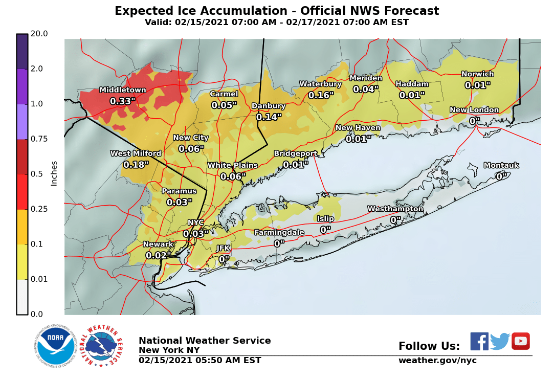
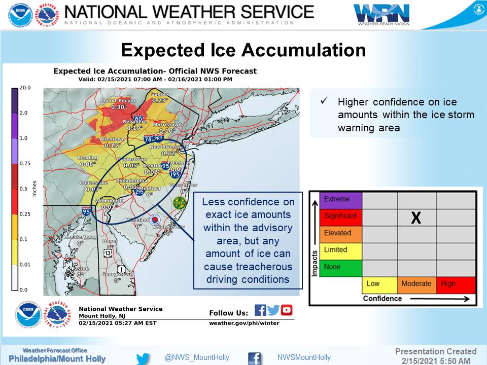
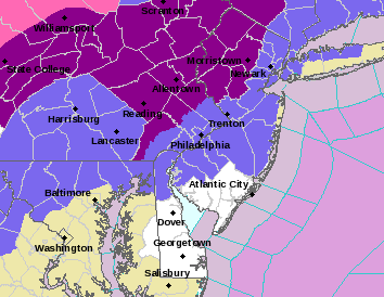
Just focusing on tonight, the NWS didn't change any of their advisories or ice storm warnings vs. what they issued yesterday afternoon. However, they noted in the updated map from the NWS-Philly that the forecasted freezing rain along/near 95 is not high confidence, which is what I said after looking at last night's models. Given that the most likely time for freezing rain in this area is between 7 pm and 3 am, the impacts will be lessened and that entire area should be above 32F well before sunrise on Tuesday, with no impact on the morning rush hour, even if some freezing rain falls before then, as it will be melted by the heavy rain.

I'm actually surprised they've kept the ice storm warnings up for Somerset, Hunterdon, and Morris in NJ and NW Chester, NW Montco and NW Bucks in PA, as it's highly doubtful these areas (especially the SE parts of the counties) reach the 0.25" ice storm warning criterion. But we'll see. For Sussex, Warren (and NW Morris), the Lehigh Valley/Poconos and the Hudson Valley, this could be a pretty bad icing situation.

https://www.weather.gov/phi/
6ICoyPP.png


wiU3dCb.png
If most of the 12Z (7 am EST data inputs) models (not all) which just came out are right, it's "Ice Storm Cancel" time for everyone except far NW locations, like the Poconos and NW Sussex and Orange Cty NY and NW of there, as they're all showing temps warming up faster and further than they showed yesterday or last night, meaning less freezing rain. At the very least I'd be surprised if the advisories stay up for the 95 corridor counties and maybe the ice storm warnings move to advisories for the NW areas.

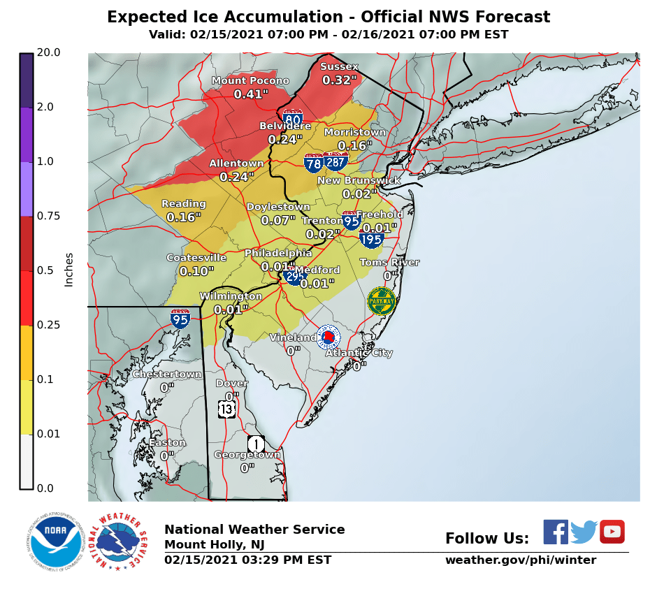
I crashed and burned on my NWS prediction, as they didn't change a thing in their forecast advisories/warnings, but at least they explained why and noted the discrepancies between most of the models and NAM/CAMS, which they put more confidence in - but I doubt they saw the 18Z NAM with no freezing rain (ZR) anywhere along or near the 95 corridor when they wrote this - the 12Z NAM this morning was the only model I saw that had a little bit of freezing rain along 95 (up to 0.1").

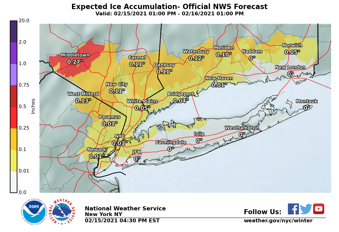
In fact, they even increased ice forecasts by a tad for most, as per the ice maps below. I still think there will not be any ZR along 95 and less than forecast to the NW, since the vast majority of models show no ice SE of a line from about New Hope to Morristown to White Plains. We'll see soon. Temps are currently slightly above 32F, but with wet-bulbing (we're not at 100% RH yet and it'll cool a bit when we get to there), temps would be 31-32F for many along 95, so I guess precip could start out as a little freezing rain this evening. Worth watching out for.

https://forecast.weather.gov/produc...&format=CI&version=1&glossary=1&highlight=off

National Weather Service Mount Holly NJ
346 PM EST Mon Feb 15 2021

NEAR TERM /THROUGH TUESDAY/...

**Significant icing still expected for portions of eastern
Pennsylvania and northern New Jersey tonight into early Tuesday
morning**

The storm system that has been affecting the Deep South will
continue to lift northward near the Appalachians, while a secondary
low is forecast to develop and lift northward along the eastern
seaboard tonight through early Tuesday morning. The question becomes
where this secondary low develops and it`s track across the area.
The farther east it goes, the more likely freezing rain will linger
across the northern areas. If it takes even a slightly farther west
shift, the warmer temperatures that a lot of guidance is showing
will take over and change the precipitation to all rain. The cold
high pressure remains across the northern Mississippi Vally, while
nosing around the Great Lakes region and across New England and into
the Mid Atlantic region. The concern is the bend in the surface
pressure fields that noses its way into the Mid Atlantic region,
which continues to indicate a good probability of a cold air damming
situation, even with 2m temperatures forecast trying to warm everyone
above freezing quickly. - Precipitation will begin as a mix of rain where
temperatures are above, and freezing rain and sleet where
temperatures are below freezing, with some snow possible across the
Poconos. Where temperatures stay below freezing through the evening
and overnight , freezing rain becomes the predominate precipitation
type as the warm nose aloft continues to push northward and sleet
becomes less likely. We continue with the Winter Weather Advisories
for portions of southeast Pennsylvania, northern Delaware, and
southern New Jersey where a brief period of freezing rain is
expected to occur before temperatures warm above freezing this
evening and overnight. A glaze of ice and up to a tenth of an inch
of ice is possible in these areas. An Ice Storm Warning remains in
effect for portions of eastern Pennsylvania and northern New Jersey
where ice amounts are forecast to be as much as one-quarter to one-
half of an inch of ice in some areas before many areas warm above
freezing.

Precipitation will be ending from southwest to northeast during the
morning into the early afternoon Tuesday, so the Warnings will
continue into the mid morning hours. As the storm continues to pull
away and precipitation comes to an end across much of the area, some
snow showers will be possible across portions of northeast
Pennsylvania and northern New Jersey into Tuesday afternoon and
evening. Little to no accumulation is expected if any showers do
develop. Tuesday will warm up quite a bit, so we can expect much of
the ice that fell overnight, in addition to some but not all snow on
the ground to melt some during the day.
LWVJYsU.png


0Yxm8Jx.png


jKGmJFv.png
 
Last edited:
This was the first snow in over 1100 days, so I am not complaining.

looks great, and I won’t starve. I just hope the pipes don’t burst and the heat stays on. Officials are asking people to lower their thermostats to 55 at night and 65 during the day.

THAT isn’t going to happen at my house unless I lose power.
I'm sure you know this, but in case not, keep your water dripping with all the valves open (except the faucet obviously), to greatly reduce the possibility of pipes freezing and bursting. Good luck!
 
I play tennis in Washington Crossing every Monday night until 9. I’ll know on the drive home whether there’s any ice. Hopefully stays well to our north.
 
I'm sure you know this, but in case not, keep your water dripping with all the valves open (except the faucet obviously), to greatly reduce the possibility of pipes freezing and bursting. Good luck!

Should I leave the hot water or cold water dripping? Or both?

We really don’t have to deal with this very often.

Wind chill warning issued for Arkansas. NEVER has that happened! Wind chills are expected to be minus 16 to minus 26 tomorrow!
 
I'm sure you know this, but in case not, keep your water dripping with all the valves open (except the faucet obviously), to greatly reduce the possibility of pipes freezing and bursting. Good luck!
I just saw on the TV a report that said this is the first ice storm warning for this area in 10 years .
 
Philly and East will not have any sleet or ice. Too warm. Temps to go up overnight. Will be 47 by 4am.
 
Should I leave the hot water or cold water dripping? Or both?

We really don’t have to deal with this very often.

Wind chill warning issued for Arkansas. NEVER has that happened! Wind chills are expected to be minus 16 to minus 26 tomorrow!
Cold water is fine. The main point is to have a litle flow from outside the house through all the valves to the sink (all those valves should be fully open), as movement decreases the likelihood of freezing (like a stream), plus having the valve open means that should the water freeze between where it comes into your house and the first valve, having that valve open provides some volume for expansion, as water expands by several % in volume when it freezes (it's why ice floats, which is critical to life on earth in many ways), as the molecules are less tightly packed in an ordered crystalline state than they are in the liquid state.
 
  • Like
Reactions: Southern Gentleman
This was the first snow in over 1100 days, so I am not complaining.

looks great, and I won’t starve. I just hope the pipes don’t burst and the heat stays on. Officials are asking people to lower their thermostats to 55 at night and 65 during the day.

THAT isn’t going to happen at my house unless I lose power.
Is your furnace able to keep up with temperatures this cold?
 
Light freezing rain reported in Bethlehem, Clinton, Scotch Plains and Islip with temps at 31-32F. Just light rain in Lansdale, Ewing and S. Brunswick with temps just above 32F. It has cooled a little the past few hours, so I think the next few hours will be a close call for the 95 corridor and NW of there, from Trenton NE-ward; doubtful any freezing rain SW of Trenton with temps 34-36F towards Phillly. Currently 33F with wet bulb temps around 31F in the Princeton to NB to NYC corridor, meaning freezing rain is still possible for at least the next few hours if we see precip (on our doorstep here in Metuchen).

6:30 edit: Light rain just started here, although it's very light rain and the reported RH is 92% which gives a wet bulb temp of 31.5F, so freezing rain is not out of the question yet. I did just check and no signs of anything freezing yet outside.
 
Last edited:
Cold water is fine. The main point is to have a litle flow from outside the house through all the valves to the sink (all those valves should be fully open), as movement decreases the likelihood of freezing (like a stream), plus having the valve open means that should the water freeze between where it comes into your house and the first valve, having that valve open provides some volume for expansion, as water expands by several % in volume when it freezes (it's why ice floats, which is critical to life on earth in many ways), as the molecules are less tightly packed in an ordered crystalline state than they are in the liquid state.

Thanks! they are now calling for another 5-8 inches on Wednesday in Little Rock. And up to 2 inches of sleet/ ice in Southern Arkansas. Snow is always better than ice!
 
  • Like
Reactions: RU848789
Is your furnace able to keep up with temperatures this cold?

quick answer....No.

the fireplace helps. Wearing several layers of clothes help as well.

I asked the wife if she wants to get in the hot tub.......”hell no! Are you crazy?”

probably a good thing as the snow drift around it is almost 3 feet tall.
 
  • Like
Reactions: WhiteBus
quick answer....No.

the fireplace helps. Wearing several layers of clothes help as well.

I asked the wife if she wants to get in the hot tub.......”hell no! Are you crazy?”

probably a good thing as the snow drift around it is almost 3 feet tall.
Best time ever for the hot tub is during snow. And that big drift is perfect for keeping your beverage chilled.
 
Light freezing rain reported in Bethlehem, Clinton, Scotch Plains and Islip with temps at 31-32F. Just light rain in Lansdale, Ewing and S. Brunswick with temps just above 32F. It has cooled a little the past few hours, so I think the next few hours will be a close call for the 95 corridor and NW of there, from Trenton NE-ward; doubtful any freezing rain SW of Trenton with temps 34-36F towards Phillly. Currently 33F with wet bulb temps around 31F in the Princeton to NB to NYC corridor, meaning freezing rain is still possible for at least the next few hours if we see precip (on our doorstep here in Metuchen).

6:30 edit: Light rain just started here, although it's very light rain and the reported RH is 92% which gives a wet bulb temp of 31.5F, so freezing rain is not out of the question yet. I did just check and no signs of anything freezing yet outside.

Freezing line is running from roughly Quakertown to Branchburg to Elizabeth with light freezing drizzele in some locations along and NW of that line. I really don't think most of these advisories and warnings are going to verify. 33F here and the drizzle we had was plain rain.
 
If most of the 12Z (7 am EST data inputs) models (not all) which just came out are right, it's "Ice Storm Cancel" time for everyone except far NW locations, like the Poconos and NW Sussex and Orange Cty NY and NW of there, as they're all showing temps warming up faster and further than they showed yesterday or last night, meaning less freezing rain. At the very least I'd be surprised if the advisories stay up for the 95 corridor counties and maybe the ice storm warnings move to advisories for the NW areas.

I crashed and burned on my NWS prediction, as they didn't change a thing in their forecast advisories/warnings, but at least they explained why and noted the discrepancies between most of the models and NAM/CAMS, which they put more confidence in - but I doubt they saw the 18Z NAM with no freezing rain (ZR) anywhere along or near the 95 corridor when they wrote this - the 12Z NAM this morning was the only model I saw that had a little bit of freezing rain along 95 (up to 0.1").

In fact, they even increased ice forecasts by a tad for most, as per the ice maps below. I still think there will not be any ZR along 95 and less than forecast to the NW, since the vast majority of models show no ice SE of a line from about New Hope to Morristown to White Plains. We'll see soon. Temps are currently slightly above 32F, but with wet-bulbing (we're not at 100% RH yet and it'll cool a bit when we get to there), temps would be 31-32F for many along 95, so I guess precip could start out as a little freezing rain this evening. Worth watching out for.

https://forecast.weather.gov/produc...&format=CI&version=1&glossary=1&highlight=off

National Weather Service Mount Holly NJ
346 PM EST Mon Feb 15 2021

NEAR TERM /THROUGH TUESDAY/...

**Significant icing still expected for portions of eastern
Pennsylvania and northern New Jersey tonight into early Tuesday
morning**

The storm system that has been affecting the Deep South will
continue to lift northward near the Appalachians, while a secondary
low is forecast to develop and lift northward along the eastern
seaboard tonight through early Tuesday morning. The question becomes
where this secondary low develops and it`s track across the area.
The farther east it goes, the more likely freezing rain will linger
across the northern areas. If it takes even a slightly farther west
shift, the warmer temperatures that a lot of guidance is showing
will take over and change the precipitation to all rain. The cold
high pressure remains across the northern Mississippi Vally, while
nosing around the Great Lakes region and across New England and into
the Mid Atlantic region. The concern is the bend in the surface
pressure fields that noses its way into the Mid Atlantic region,
which continues to indicate a good probability of a cold air damming
situation, even with 2m temperatures forecast trying to warm everyone
above freezing quickly. - Precipitation will begin as a mix of rain where
temperatures are above, and freezing rain and sleet where
temperatures are below freezing, with some snow possible across the
Poconos. Where temperatures stay below freezing through the evening
and overnight , freezing rain becomes the predominate precipitation
type as the warm nose aloft continues to push northward and sleet
becomes less likely. We continue with the Winter Weather Advisories
for portions of southeast Pennsylvania, northern Delaware, and
southern New Jersey where a brief period of freezing rain is
expected to occur before temperatures warm above freezing this
evening and overnight. A glaze of ice and up to a tenth of an inch
of ice is possible in these areas. An Ice Storm Warning remains in
effect for portions of eastern Pennsylvania and northern New Jersey
where ice amounts are forecast to be as much as one-quarter to one-
half of an inch of ice in some areas before many areas warm above
freezing.

Precipitation will be ending from southwest to northeast during the
morning into the early afternoon Tuesday, so the Warnings will
continue into the mid morning hours. As the storm continues to pull
away and precipitation comes to an end across much of the area, some
snow showers will be possible across portions of northeast
Pennsylvania and northern New Jersey into Tuesday afternoon and
evening. Little to no accumulation is expected if any showers do
develop. Tuesday will warm up quite a bit, so we can expect much of
the ice that fell overnight, in addition to some but not all snow on
the ground to melt some during the day.


LWVJYsU.png


0Yxm8Jx.png


jKGmJFv.png

Well I may have been wrong about what the NWS was going to do at 4 pm, but one could look at it as they were just late to the party. They finally just cancelled many of the advisories and converted the ice storm warnings to advisories for all but Sussex, Warren, Morris, W. Passaic, the Lehigh Valley and the Poconos. I get that they wanted to make sure since freezing rain is so dangerous, however.

National Weather Service Mount Holly NJ
712 PM EST Mon Feb 15 2021

.SYNOPSIS...
A strong low pressure system is forecast to cross the Mid-Atlantic
region tonight into Tuesday. High pressure builds out of the
Great Lakes and into the northeast through Wednesday night.
Another storm system is forecast to affect the area Thursday
into Friday. High pressure then builds in over the weekend.

&&

.NEAR TERM /THROUGH TUESDAY/...
Based on latest surface obs, went ahead and made some changes to
the forecast and the hazards.

For most areas just south and east of I-95, temperatures are
above freezing and should mostly stay above freezing as
temperatures slowly rise into the evening. As a result,
expecting plain rain in these areas.

Went ahead and cancelled the Winter Weather Advisory that was
in effect for the following counties: New Castle, Delaware, and
in New Jersey, Salem, Gloucester, Camden, Southeast Burlington,
Ocean, and Western Monmouth. Enough of Northwest Burlington is
marginal in terms of temperatures and timing of precipitation
arrival, so will keep the Winter Weather Advisory up there.

For the next tier of counties north of I-95, Hunterdon,
Somerset, Western Chester, Western Montgomery, and Upper Bucks,
there looks to be a little less precipitation and a little less
ice, so went ahead and converted the Ice Storm Warning to a
Winter Weather Advisory as total ice will be less than 1/4 inch.

Otherwise, significant icing still expected for portions of
eastern Pennsylvania and northern New Jersey tonight into early
Tuesday morning.

i4N6vcs.png
 
My liver may not be up to this!

It's covid times, your liver should be fully trained over the past year and in peak shape to handle anything you can throw at it.

I asked the wife if she wants to get in the hot tub.......”hell no! Are you crazy?”
probably a good thing as the snow drift around it is almost 3 feet tall.

All time, best time to be in the hot tub. You should take advantage of these rare snow events for your area.
 
Well I may have been wrong about what the NWS was going to do at 4 pm, but one could look at it as they were just late to the party. They finally just cancelled many of the advisories and converted the ice storm warnings to advisories for all but Sussex, Warren, Morris, W. Passaic, the Lehigh Valley and the Poconos. I get that they wanted to make sure since freezing rain is so dangerous, however.

National Weather Service Mount Holly NJ
712 PM EST Mon Feb 15 2021

.SYNOPSIS...
A strong low pressure system is forecast to cross the Mid-Atlantic
region tonight into Tuesday. High pressure builds out of the
Great Lakes and into the northeast through Wednesday night.
Another storm system is forecast to affect the area Thursday
into Friday. High pressure then builds in over the weekend.

&&

.NEAR TERM /THROUGH TUESDAY/...
Based on latest surface obs, went ahead and made some changes to
the forecast and the hazards.

For most areas just south and east of I-95, temperatures are
above freezing and should mostly stay above freezing as
temperatures slowly rise into the evening. As a result,
expecting plain rain in these areas.

Went ahead and cancelled the Winter Weather Advisory that was
in effect for the following counties: New Castle, Delaware, and
in New Jersey, Salem, Gloucester, Camden, Southeast Burlington,
Ocean, and Western Monmouth. Enough of Northwest Burlington is
marginal in terms of temperatures and timing of precipitation
arrival, so will keep the Winter Weather Advisory up there.

For the next tier of counties north of I-95, Hunterdon,
Somerset, Western Chester, Western Montgomery, and Upper Bucks,
there looks to be a little less precipitation and a little less
ice, so went ahead and converted the Ice Storm Warning to a
Winter Weather Advisory as total ice will be less than 1/4 inch.

Otherwise, significant icing still expected for portions of
eastern Pennsylvania and northern New Jersey tonight into early
Tuesday morning.

i4N6vcs.png
That seems to happen somewhat frequently the last couple of years - late to change a “forecast” that is obviously not panning out to anyone watching the radar trends - or constantly adjusting amounts up/down/up after the storm is already underway - and then ultimately being off on where they leave it.
 
  • Like
Reactions: bac2therac
That seems to happen somewhat frequently the last couple of years - late to change a “forecast” that is obviously not panning out to anyone watching the radar trends - or constantly adjusting amounts up/down/up after the storm is already underway - and then ultimately being off on where they leave it.
I think it happens much more frequently with potential freezing rain events, because these are nearly impossible to forecast well even 6 hours in advance for all the reasons I've outlined previously, meaning the uncertainty is significantly higher than for just a snow or rain forecast, plus the impact of a freezing rain event is seriously outsized vs. how much falls, i.e., 0.10" of ice makes a skating rink, while 1" of snow (same amount of precip) is kind of chuckled at by most as nuisance snow, and 0.25" of freezing rain is where damage to trees/wires starts and travel becomes impossible, whereas 2.5" of snow (same amount of precip) is considered a "nice little snowstorm."

Given all that, the NWS, I'm sure, simply takes a much more conservative approach, since underwarning and being wrong is catastrophic (like the 100+ car pile-up in TX that killed 6 a few days ago), whereas overwarning and being wrong simply means some people were inconvenienced. Makes sense to me, since I spent a lot of time doing emergency risk management in my work for a 5000-person R&D/manufacturing site.
 
NWS dropped the advisories along 95 in SE PA/SNJ, but they're still up in most places, which is a bit silly at this point, as the only place it's at or below 32F is Sussex, Warren, NW Morris and W. Passaic, in NJ, and in the Poconos and mid-Hudson Valley, where there are reports of significant icing, as expected.

150469876_10221054507346388_1002998227431236232_n.jpg
 
9am and still waiting

It was a MAJOR bust and we all knew it by looking at the radar at 2pm yesterday

Some on the other hand....
+1
MAJOR BUST this entire week. Warnings almost everyday and absolutely nothing. What a joke!

🤣😂🤣😂🤣😂🤣
 
I'm sure you know this, but in case not, keep your water dripping with all the valves open (except the faucet obviously), to greatly reduce the possibility of pipes freezing and bursting. Good luck!
Should I open up the valves to my 2 hoses? I always shut them off for the winter, one is near the back or the house and the other is near the front of the house. I also turn the lever's to the off position - not sure why I do this, imagine someone told me to once we bought the house
 
Should I open up the valves to my 2 hoses? I always shut them off for the winter, one is near the back or the house and the other is near the front of the house. I also turn the lever's to the off position - not sure why I do this, imagine someone told me to once we bought the house

My line to the outside is in the garage which isn't heated. My HVAC guy told me to shut the water off at the connection to the main (which has a heating coil) during the winter but leave the fauct open. Don't know why just figured he knew what he was talking about.
 
ADVERTISEMENT
ADVERTISEMENT