You would be the expert on that first part. Not so much the impressive part.4 self fellating posts in a row. Impressive!


Colleges
- AAC
- ACC
- Big 12
- Big East
- Big Ten
- Pac-12
- SEC
- Atlantic 10
- Conference USA
- Independents
- Junior College
- Mountain West
- Sun Belt
- MAC
- More
- Navy
- UAB
- Tulsa
- UTSA
- Charlotte
- Florida Atlantic
- Temple
- Rice
- East Carolina
- USF
- SMU
- North Texas
- Tulane
- Memphis
- Miami
- Louisville
- Virginia
- Syracuse
- Wake Forest
- Duke
- Boston College
- Virginia Tech
- Georgia Tech
- Pittsburgh
- North Carolina
- North Carolina State
- Clemson
- Florida State
- Cincinnati
- BYU
- Houston
- Iowa State
- Kansas State
- Kansas
- Texas
- Oklahoma State
- TCU
- Texas Tech
- Baylor
- Oklahoma
- UCF
- West Virginia
- Wisconsin
- Penn State
- Ohio State
- Purdue
- Minnesota
- Iowa
- Nebraska
- Illinois
- Indiana
- Rutgers
- Michigan State
- Maryland
- Michigan
- Northwestern
- Arizona State
- Oregon State
- UCLA
- Colorado
- Stanford
- Oregon
- Arizona
- California
- Washington
- USC
- Utah
- Washington State
- Texas A&M
- Auburn
- Mississippi State
- Kentucky
- South Carolina
- Arkansas
- Florida
- Missouri
- Ole Miss
- Alabama
- LSU
- Georgia
- Vanderbilt
- Tennessee
- Louisiana Tech
- New Mexico State
- Middle Tennessee
- Western Kentucky
- UTEP
- Florida International University
High School
- West
- Midwest
- Northeast
- Southeast
- Other
- Alaska
- Arizona
- California
- Colorado
- Nevada
- New Mexico
- Northern California
- Oregon
- Southern California Preps
- Washington
- Edgy Tim
- Indiana
- Kansas
- Nebraska
- Iowa
- Michigan
- Minnesota
- Missouri
- Oklahoma Varsity
- Texas Basketball
- Texas
- Wisconsin
- Delaware
- Maryland
- New Jersey Basketball
- New Jersey
- New York City Basketball
- Ohio
- Pennsylvania
- Greater Cincinnati
- Virginia
- West Virginia Preps
ADVERTISEMENT
Install the app
How to install the app on iOS
Follow along with the video below to see how to install our site as a web app on your home screen.
Note: This feature may not be available in some browsers.
You are using an out of date browser. It may not display this or other websites correctly.
You should upgrade or use an alternative browser.
You should upgrade or use an alternative browser.
OT: Significant Winter Storm 2/27-28 (esp along/N of 78); and update on Fri storm (p. 6)
- Thread starter RU848789
- Start date

Minor and sig([nificant are not synonymous. Check the title of the thread and #s defense of significant.my comment stands
the forecast was for a minor storm.
it was a minor storm.
the snow fall basically exactly as forecasted.
how does that even remotely classify as a "massive bust"?
#'s choice to use the word "significant" in the title of this thread has no bearing.
Minor and sig([nificant are not synonymous. Check the title of the thread and #s defense of significant.
you need a hobby
I was just watching NBC news. They claim to call on 10 forecasters to broadcast the weather reports. I think News 12 does the same. How much do they all make? Do they get paid by the Storm Watch only? Just curious. Seems like a lot of ways to divide the segment cost, especially for the locals.
I thought it was an attempted Javascript injection attackI am unfamiliar with the word "sig([nificant".
Delayed opening in Hillsborough for an event that washed off the roads by midnight
But I think we can all agree that the fact schools were delayed had absolutely zero affect on your life, right?
Thanks for the work and accurate updates, Numbers. I planned accordingly and the forecasts were correct. You saved me from a small hassle.
Delayed opening in Hillsborough for an event that washed off the roads by midnight
But muh hero teachers!
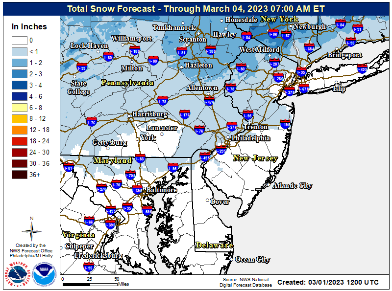
Excellent point about the NWS forecast being impressive and that the descriptor used is far less important than the quality of the information presented. However, given that most mets I've seen would define a "significant" snowfall as in the 3-6"/4-8" range, meaning at least 3-4" falling, I would say the descriptor was reasonable for areas along/N of 78, where 3" or more were being forecast by the NWS. Or if one thinks 4" is the cutoff for "significant" then the descriptor was good for areas partway between 78 and 80, where the 4" forecast line was. Certainly, south of 78 and especially more than 5-10 miles south of 78 where 2" or less were forecast, this was projected to be a minor storm (although personally, given <1/2" of snow this season so far, 2" was major to me, lol). Just about all of that verified reasonably well.my comment stands
the forecast was for a minor storm.
it was a minor storm.
the snow fall was basically exactly within the ranges forecasted as shown above. impressively so.
how does that even remotely classify as a "massive bust"?
#'s choice to use the word "significant" in the title of this thread has no bearing on the topic of the accuracy of the forecast ... except to provide an opportunity, for the few who feel strangely compelled to give #'s shit, to call him for his word usage. these people need to get a life.
But muh hero teachers!
Don't encourage him, he'll just say more stupid shit.
Don't encourage him, he'll just say more stupid shit.
Does anyone else draw a mental picture of Derek Zoolander whenever you read his posts?
Last edited:
Yup. Dumb decision. Most other local schools ignored the wishcasting and started on time.Delayed opening in Hillsborough for an event that washed off the roads by midnight
Here's the monthly/annual Sedona snowfall since 1944, although for some reason it stops at 2010. The crazy thing is the huge variability over time, in that the mean is 3.8" per winter, but the standard deviation is 9.8" per winter, which is huge, because there are so many winters with no snow, but then a few winters with huge snowfall, including the record of 51" in 48-49.That's hard to pin down. Can't find an accurate website with data. It has not snowed much in the last 5-10 years, so this winter feels higher than normal. But found this:
How many days does it snow in Sedona?
Throughout the year, in Sedona, Arizona, there are 10.6 snowfall days, and 8.9" (226mm) of snow is accumulated.
Sedona, AZ - Climate & Monthly weather forecast
Sedona, Arizona - Climate and weather forecast by month. Detailed climate information with charts - average monthly weather with temperature, pressure, humidity, precipitation, wind, daylight, sunshine, visibility, and UV index data.www.weather-us.com

Weather averages Sedona, Arizona
Climate Data Sedona. Monthly temperature, precipitation and climate graph.www.usclimatedata.com
https://wrcc.dri.edu/cgi-bin/cliMAIN.pl?az7708
With regard to total precip, the annual average is 17.8", reflecting the arid climate, and the average precip from Dec through March is about 7.6".
https://wrcc.dri.edu/cgi-bin/cliMAIN.pl?az7708
All I know is if it snows in Sedona in 2 weeks, I'm gonna be pissed.
But I think we can all agree that the fact schools were delayed had absolutely zero affect on your life, right?
How is your boycott of Comcast going
Yup. Dumb decision. Most other local schools ignored the wishcasting and started on time.
Any paved surface was washed away by midnight..not sure why schools are cancelling the night before..it was never progged to be that kind of storm on the roads
And who freakin’ cares? You have more important concerns this time of year. It helped a little with my commute this morning, so it’s a positive in my book.Any paved surface was washed away by midnight..not sure why schools are cancelling the night before..it was never progged to be that kind of storm on the roads
Weather.com would have been equally helpful.And who freakin’ cares? You have more important concerns this time of year. It helped a little with my commute this morning, so it’s a positive in my book.
#learntofish
:)
Weather.com would have been equally helpful.
#learntofish
:)
You want to learn to fish?
I'll take ya fishing. Head out to the Canyon, maybe 100 miles or so offshore.
I’m good. I was going into work either way and what I meant was the delayed openings helped with my commute. It seemed easy to grasp, but I’m sorry if that was too complicated for you. 😎Weather.com would have been equally helpful.
#learntofish
:)
Brief update on the Friday storm; have all day plans, so might not get to a thread with a lot more detail until late today (or maybe someone else will start a thread - don't care).Current forecast by most is for mostly rain, so if that verifies, no. However, there are some models showing a few inches of snow for EWR for Friday afternoon/evening, so if things trend toward a colder/snowier solution, it's possible there could be delays (probably minor, as temps will likely be at or just above 32F, limiting accumulation on pavement and certainly on treated surfaces). Still a little early to know for sure.
The Friday storm is looking more wet than white for most and much rainier than Monday's storm. Still looks like mainly a rainstorm south of 80 (and S/E of 287 from 80 up and around to Port Chester NY) with 1-1.5" of rain likely from Friday afternoon until before sunrise on Saturday (which could lead to localized urban flooding, but stream flooding is unlikely), although the precip could start as snow/sleet as far south as 276/195 with up to 1" snow/sleet possible especially as one gets close to 78.
Along and N of 80 (and N/W of the 80/287 intersection) there could be 1-2" of snow sleet before the changeover to rain. However, for far NWNJ (Sussex and NW Passaic mostly), the Poconos (Carbon/Monroe), and the Hudson Valley N of 287/Tappan Zee, there could also be 0.1-0.25" of freezing rain accretion on top of a couple of inches of snow/sleet, which could make it pretty treacherous Friday afternoon into the overnight; even there, though the precip will likely change to rain for awhile overnight.
Note that there is a chance this storm could trend colder and bring more impactful wintry weather as far south as the 78 corridor, but that's not the current forecast. Also, note that this should be a nice snowfall for the Catskills/Adriondacks and the interior New England ski resorts (6-12").
https://www.weather.gov/phi/

Just Mets? No Yankees?A couple of mets said the sleet was likely due to lighter precip and poor snow growth up at ~15K feet and should flip to snow, as precip intensity increases and snow crystals grow better up around 15K feet, as it has over the last 15 minutes in most of EPA. All snow here now and falling decently with a coating on the ground.
If my mom was still with us, she would sayBut I think we can all agree that the fact schools were delayed had absolutely zero affect on your life, right?
"better safe than sorry"
In a brilliant example of subtle comic irony, @Tango Two's humorous comic strip post is truly brilliant mockery of the wanna-be mean girls clique folks. And they're all giving it a like because they apparently are missing it. 🤣
Some days, ya just gotta love the internet. 🙂
Some days, ya just gotta love the internet. 🙂
A lot of times this decision making has more to do with zero available substitutes rather than the immediate weather conditions around the school. If you have 20-40% of the staff in Somerset commuting from north of I-78 where places picked up 4+ inches you have to make a call the night before now because if those people call out to clear their driveway they may only have 1-2 subs to go around before they have to call the day.Yup. Dumb decision. Most other local schools ignored the wishcasting and started on time.
My wife teaches at a district in Somerset and they had a two hour delay precisely because of this, not the 1-2 inches of snow that didn’t stick on the road around the school. They had ZERO available subs yesterday, and is indicative of a much larger problem.
Does anyone else draw a mental picture of Derek Zoolander whenever you read his posts?
Retracted.
The yankees can't see any snowfall over their 27 World Championships...Just Mets? No Yankees?
No, because no snowflakes in the forecast.Just Mets? No Yankees?
Similar threads
- Replies
- 608
- Views
- 17K
- Replies
- 62
- Views
- 2K
OT: Minor to Moderate (2-4?) Snowfall Likely Sat morning (2/17); will be <32F, so expect slick roads
- Replies
- 213
- Views
- 5K
- Replies
- 771
- Views
- 20K
ADVERTISEMENT
Latest posts
-

-

-
 FB Recruiting 2024 Transfer Portal Thread -- Spring Window Edition
- Latest: -RUFAN4LIFE-
ADVERTISEMENT