Buy a new snow blower and this all goes away. We're counting on you.I picked the wrong winter for my snowblower to break down. The auger crank broke, and I can’t get the part. Sigh.


Colleges
- AAC
- ACC
- Big 12
- Big East
- Big Ten
- Pac-12
- SEC
- Atlantic 10
- Conference USA
- Independents
- Junior College
- Mountain West
- Sun Belt
- MAC
- More
- Navy
- UAB
- Tulsa
- UTSA
- Charlotte
- Florida Atlantic
- Temple
- Rice
- East Carolina
- USF
- SMU
- North Texas
- Tulane
- Memphis
- Miami
- Louisville
- Virginia
- Syracuse
- Wake Forest
- Duke
- Boston College
- Virginia Tech
- Georgia Tech
- Pittsburgh
- North Carolina
- North Carolina State
- Clemson
- Florida State
- Cincinnati
- BYU
- Houston
- Iowa State
- Kansas State
- Kansas
- Texas
- Oklahoma State
- TCU
- Texas Tech
- Baylor
- Oklahoma
- UCF
- West Virginia
- Wisconsin
- Penn State
- Ohio State
- Purdue
- Minnesota
- Iowa
- Nebraska
- Illinois
- Indiana
- Rutgers
- Michigan State
- Maryland
- Michigan
- Northwestern
- Arizona State
- Oregon State
- UCLA
- Colorado
- Stanford
- Oregon
- Arizona
- California
- Washington
- USC
- Utah
- Washington State
- Texas A&M
- Auburn
- Mississippi State
- Kentucky
- South Carolina
- Arkansas
- Florida
- Missouri
- Ole Miss
- Alabama
- LSU
- Georgia
- Vanderbilt
- Tennessee
- Louisiana Tech
- New Mexico State
- Middle Tennessee
- Western Kentucky
- UTEP
- Florida International University
High School
- West
- Midwest
- Northeast
- Southeast
- Other
- Alaska
- Arizona
- California
- Colorado
- Nevada
- New Mexico
- Northern California
- Oregon
- Southern California Preps
- Washington
- Edgy Tim
- Indiana
- Kansas
- Nebraska
- Iowa
- Michigan
- Minnesota
- Missouri
- Oklahoma Varsity
- Texas Basketball
- Texas
- Wisconsin
- Delaware
- Maryland
- New Jersey Basketball
- New Jersey
- New York City Basketball
- Ohio
- Pennsylvania
- Greater Cincinnati
- Virginia
- West Virginia Preps
ADVERTISEMENT
Install the app
How to install the app on iOS
Follow along with the video below to see how to install our site as a web app on your home screen.
Note: This feature may not be available in some browsers.
You are using an out of date browser. It may not display this or other websites correctly.
You should upgrade or use an alternative browser.
You should upgrade or use an alternative browser.
OT: Significant Winter Storm Likely on Thursday (2/18)
- Thread starter RU848789
- Start date

You are Bac’s biggest ass-kisser on here it’s disgusting!
The two of you are the F’ing worst! If you don’t like to read the information numbers puts on here, then do us all a favor and just don’t read the sh*t!
I go to numbers’ post as my first source of snow forecasting, not to read you kissing Bactotherac’s ass every time he sh*ts all over a post by Numbers.
It’s simple man! Just don’t open the damn post! You only come on here to give him sh*t and it’s annoying as hell to those who just want to see the latest maps and predictions.
These used to be fun threads for people who were interested.
Now they are filled with people who clearly are terrified and cry about any bit of snow, so come in here to do their own wish-casting in the most douchey ways possible. I'm not talking about Bac here.
I take pleasure in knowing most of them probably got dumped on in that big storm lol. What's the point of coming into threads just to drop mean-spirited a-hole comments? People clearly need hobbies.
HERE'S AN IDEA!
If a new "storm watch" thread starts up in the coming days, only actual forecasts can be posted. Everyone else simply plays the role of the "lurker." Look but don't talk. Meanwhile, there is another thread -- let's call it the "I have 10" on my back deck" thread. It's where we can all chime in on our measurements, Deli MILFS, which local weather forecaster is the best/worst/hottest, etc., whose forecast is/was the best/most accurate/least accurate, and when, upon the go-ahead from the Mod(s), we can literally bash each other merciless with our wit and sarcasm (all in good fun, of course).
SO, A RECAP:
Thread 1: Forecasts only -- only that handful of posters that we regularly rely on. No other comments.
Thread 2: Witty banter and immediate follow-up on ongoing/past storms. Consider it a "Basketball Game #12" type of thread -- it just goes on and on -- all in good fun, once again.
Carry on. I must go listen to Denver's Original Ska Party Band -- The Dendrites!
Last edited:
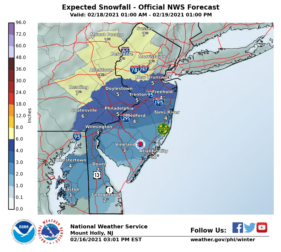
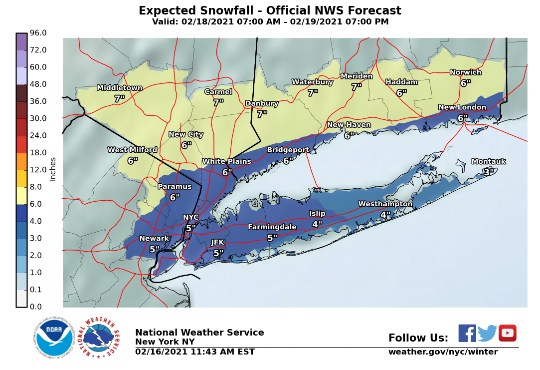
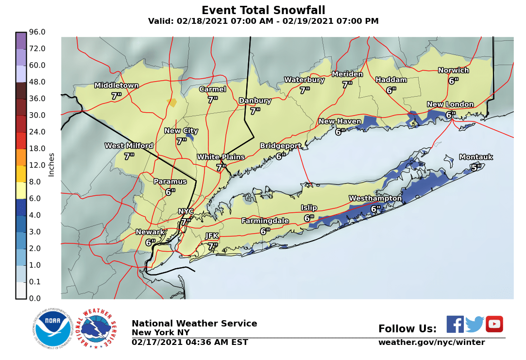
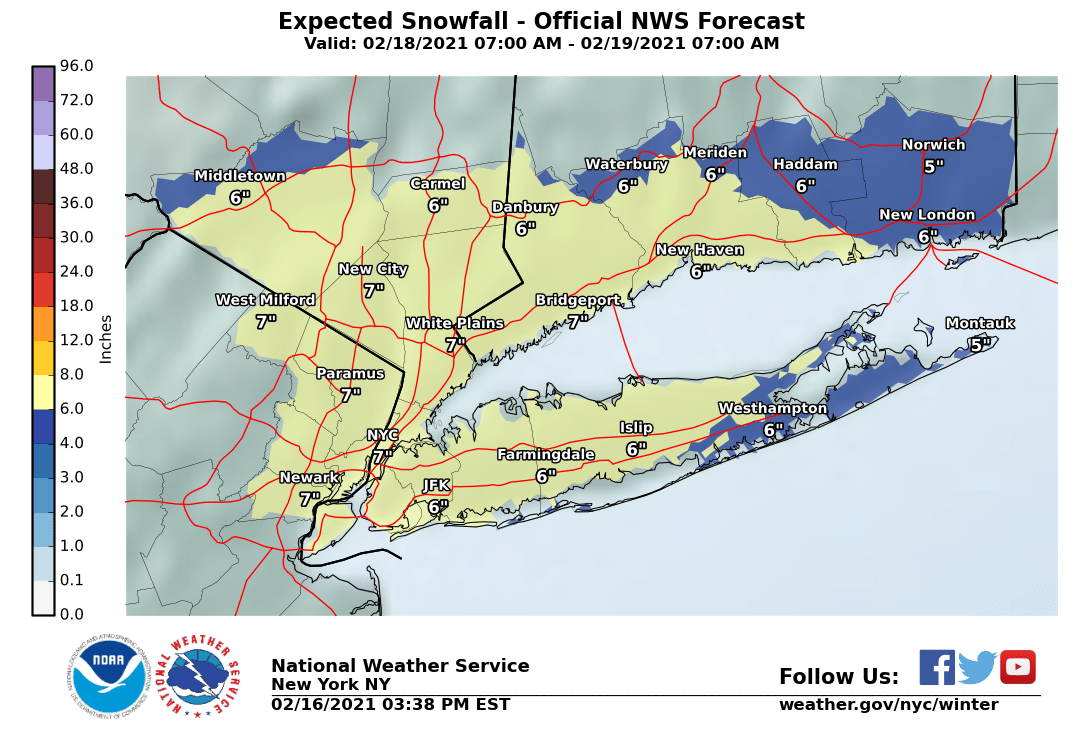
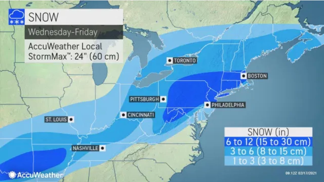
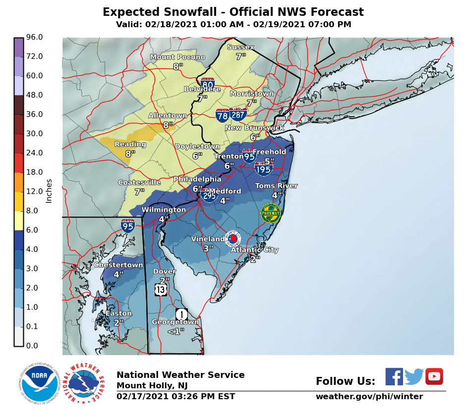
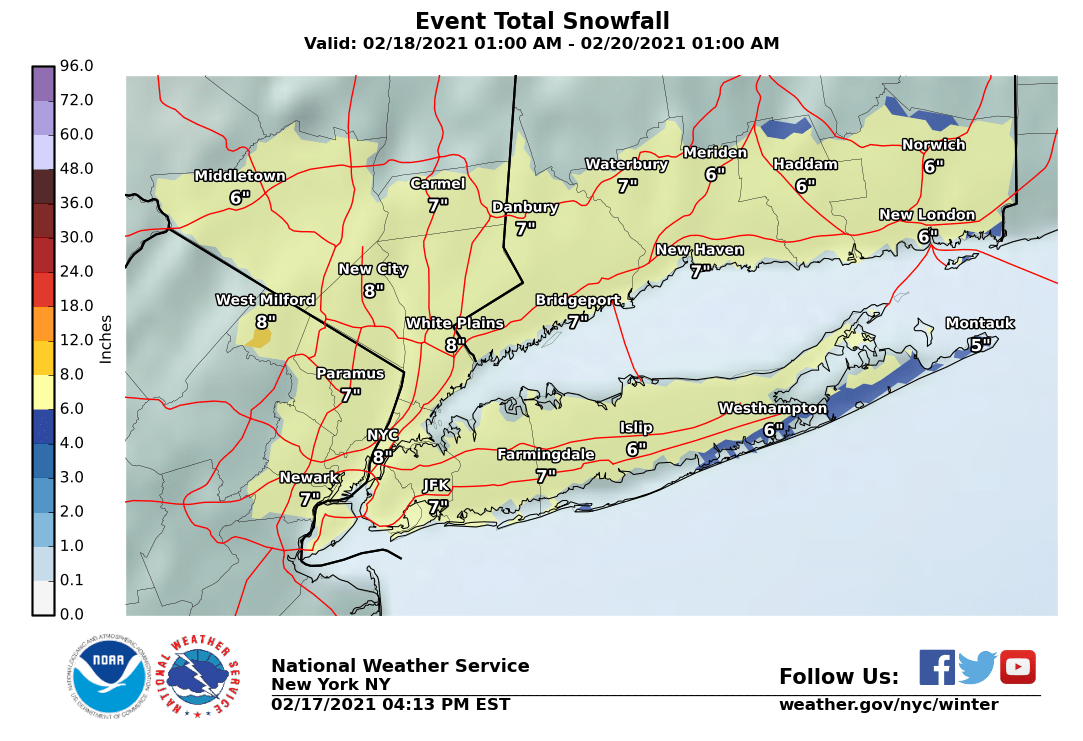
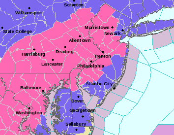
As expected, the NWS in Philly issued watches for the entire 95 corridor up to SE Bucks/Montco in PA and Mercer/Middlesex in NJ for 3-6" of snow and for all points NW of there in NNJ/NE PA for 5-8" of snow, as less mixing is expected NW of 95; watches were not issued for SENJ, since there's too much uncertainty over mixing/changeover to sleet and maybe rain. The NWS-NYC simply issued blanket watches for their entire area for 4-8" of snow (that includes Union up to Bergen in NJ, NYC, LI, and SENY/SWCT. Snow should start around sunrise Thursday and go through at least early Friday morning before sunrise. Updated maps are below.
https://www.weather.gov/phi/
Some subtle changes in tonight's 0Z model runs, with all of the models still showing an inital thump of snow from Thursday after sunrise through Thursday evening from the low pressure system while it's still down around the GOM, via a very robust upper level jet stream transporting lots of warm moist air our way along a baroclinic zone (cold to the NW/warmer to the SE), which is a 3-6"/4-8" event for most, but most of the models are now also showing some snow through Friday from a secondary coastal low, bringing a couple more inches to the area, as Friday remains cold; in this scenario there's very little rain/warming, other than maybe far SENJ.
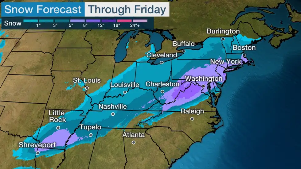
Overall snowfall amounts still look like 4-8" for almost everyone with the potential for up to 10" wherever the best banding is. I would expect very little change in the NWS forecast other than to extend the timeframe for the precip/snow. Sleet is definitely still a possibility for the latter half of Thursday along and SE of 95. Let's see what the NWW and others say in the morning. The bigger snows (>10") now seem less likely, but the likelihood of a warm/rainy solution has also gone down.
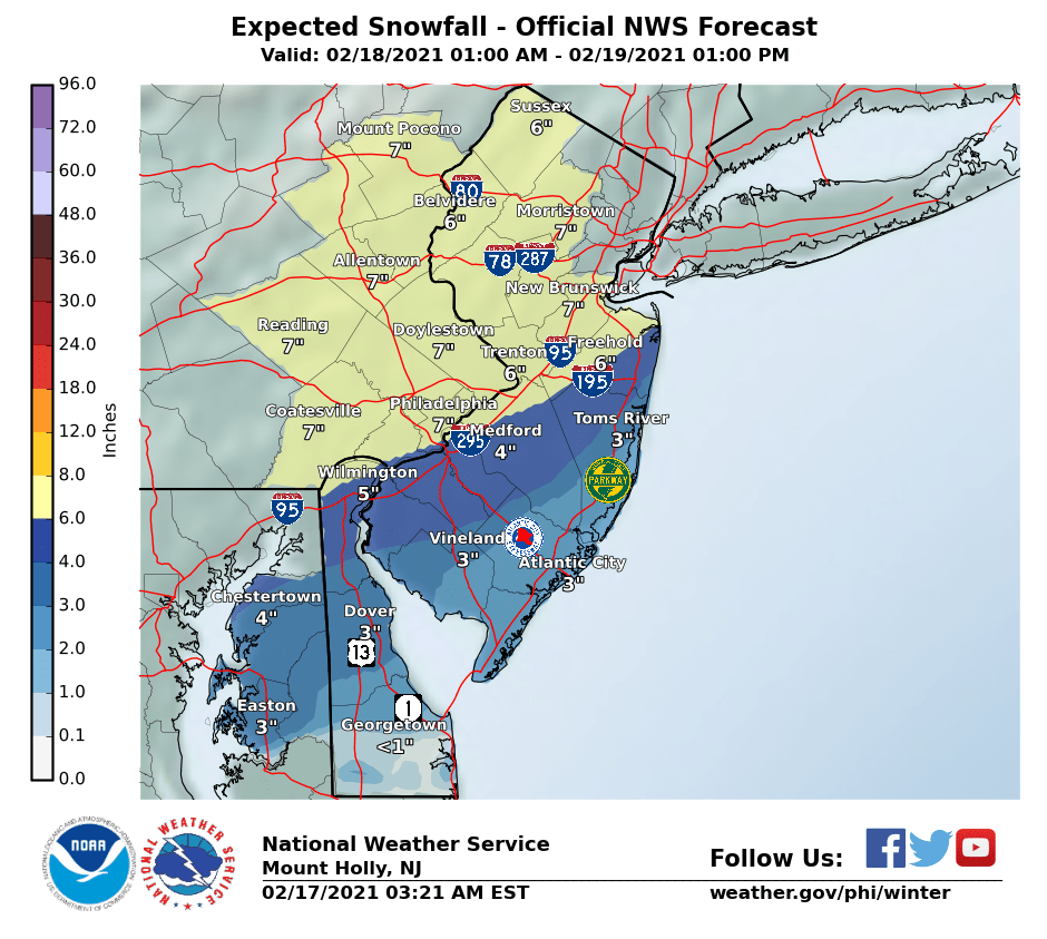
4 am edit - just adding in the updated snowfall maps, showing some small increases from both NWS offices, especially towards the coast, as the models did show a slightly colder solution there, so less mixing/changeover impact for SENJ and the coast, although sleet is still a decent risk up to the 95 corridor. Still going with watches instead of warnings, as we're borderline on getting 6" in most places and if the system evolves with a bit less snow in the forecast, they can then just go with advisories rather than warnings.
Last edited:
Some subtle changes in tonight's 0Z model runs, with all of the models still showing an inital thump of snow from Thursday after sunrise through Thursday evening from the low pressure system while it's still down around the GOM, via a very robust upper level jet stream transporting lots of warm moist air our way along a baroclinic zone (cold to the NW/warmer to the SE), which is a 3-6"/4-8" event for most, but most of the models are now also showing some snow through Friday from a secondary coastal low, bringing a couple more inches to the area, as Friday remains cold; in this scenario there's very little rain/warming, other than maybe far SENJ.
Overall snowfall amounts still look like 4-8" for almost everyone with the potential for up to 10" wherever the best banding is. I would expect very little change in the NWS forecast other than to extend the timeframe for the precip/snow. Sleet is definitely still a possibility for the latter half of Thursday along and SE of 95. Let's see what the NWW and others say in the morning. The bigger snows (>10") now seem less likely, but the likelihood of a warm/rainy solution has also gone down.
4 am edit - just adding in the updated snowfall maps, showing some small increases from both NWS offices, especially towards the coast, as the models did show a slightly colder solution there, so less mixing/changeover impact for SENJ and the coast, although sleet is still a decent risk up to the 95 corridor. Still going with watches instead of warnings, as we're borderline on getting 6" in most places and if the system evolves with a bit less snow in the forecast, they can then just go with advisories rather than warnings.
Thanks for the update. To be honest I hardly ever look at the weather report on TV or on line when snow is forecast, I just check the latest thread.
Models have cut qpf slightly from its higher amounts. Looking like 4-8 inches is a good call. However concerns about sleet remain cutting into totals.
Looking like the bulk of the snow accumulation will happen in a thump in the morning and afternoon. Precip will continue Thursday night but lighter and sleetier. Intermittent mixed bag will continue perhaps into Friday similar to the storm a few weeks ago.
Looking like the bulk of the snow accumulation will happen in a thump in the morning and afternoon. Precip will continue Thursday night but lighter and sleetier. Intermittent mixed bag will continue perhaps into Friday similar to the storm a few weeks ago.
Close call. Looking at the hourly forecast from the NWS, snow will be fairly light through about 7 am with <1", but will likely be moderate to heavy by 9 am, although will only be 1-2" on the ground by then. If ru4real were here he could answer this better, but it won't be windy, so if they can keep up with the snow on the runways, you might be ok.So I'm guessing my 9AM flight out of Philly on Friday is going to be delayed
Edit - sorry, thought this was for Thursday. Friday should be fine. Thanks @MadRU!
Last edited:
Close call. Looking at the hourly forecast from the NWS, snow will be fairly light through about 7 am with <1", but will likely be moderate to heavy by 9 am, although will only be 1-2" on the ground by then. If ru4real were here he could answer this better, but it won't be windy, so if they can keep up with the snow on the runways, you might be ok.
#s are you talking about Friday morning? That’s his question, just a FYI
yes, edited it, thanks - left it up if anyone is flying out Philly on Thursday morning, lol...#s are you talking about Friday morning? That’s his question, just a FYI
yes, edited it, thanks - left it up if anyone is flying out Philly on Thursday morning, lol...
ok, what about my street? Will it flood? lol
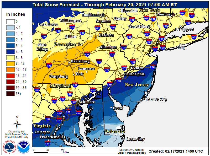
Doesn't sound right as they're calling for an area-wide 5-8" as per the map below, which is nearly identical to the NWS maps - maybe that was just a partial forecast? Speaking of the NWS, below is their regional map, which I like, as it includes both the Philly and NYC office snowfall forecasts.Weather Channel Hillsborough 3-5 inches
lol, although with the shift SE of the expected track, the NWS now has you guys in the 2-4" range, i.e., not all rain...ok, what about my street? Will it flood? lol
Winter storm to slam N.J. with heavy, wet snow. Up to 12 inches in latest AccuWeather forecast.
The National Weather Service forecast has half of New Jersey getting 6 to 8 inches of snow starting Thursday and lingering into Friday.
Doesn't sound right as they're calling for an area-wide 5-8" as per the map below, which is nearly identical to the NWS maps - maybe that was just a partial forecast? Speaking of the NWS, below is their regional map, which I like, as it includes both the Philly and NYC office snowfall forecasts.
Bottom scroll in local forcast Thursday 3-5 Friday less than an inch
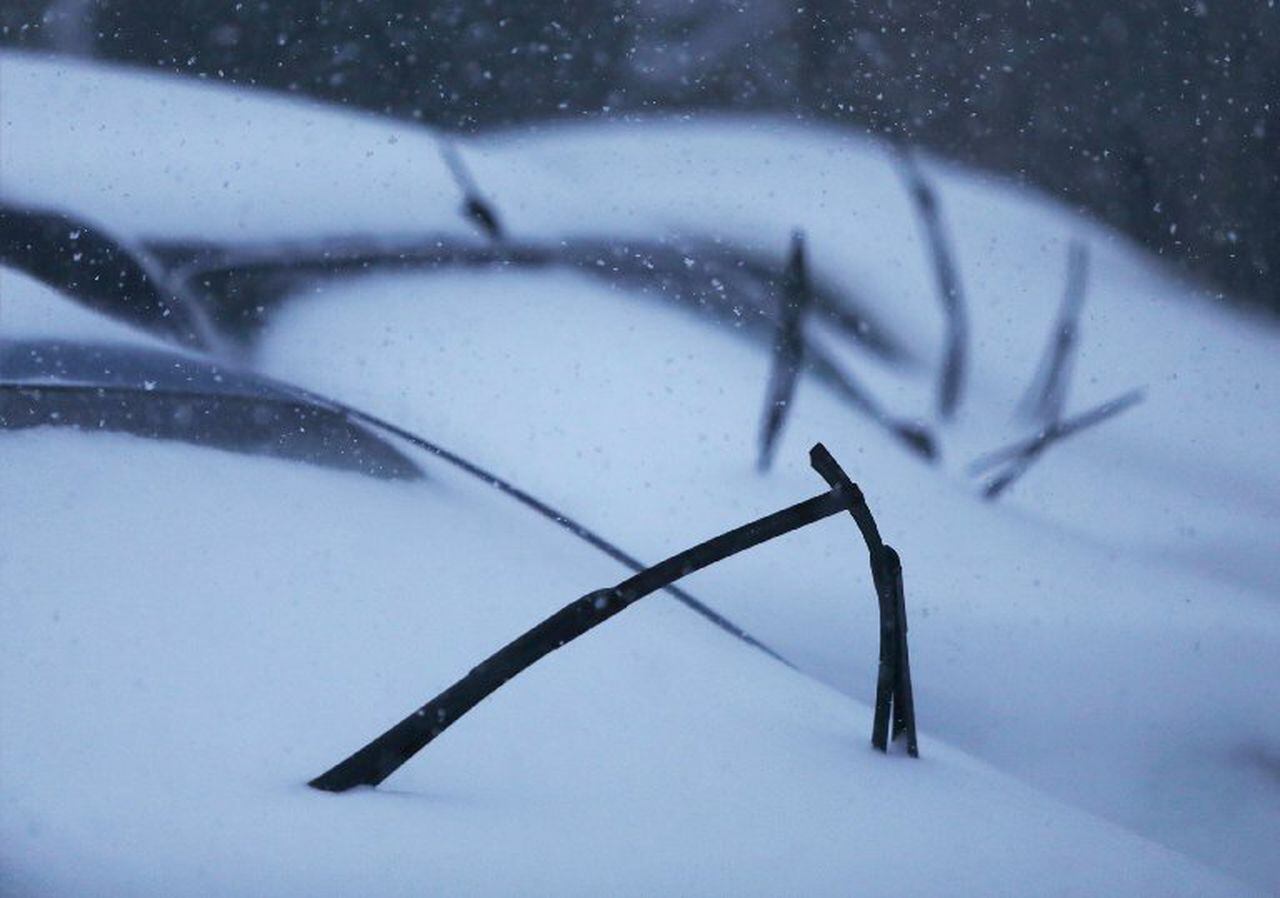
Should you leave your windshield wipers up during a storm? It’s debatable.
Here's why you should or shouldn't leave your windshield wipers up when you park your car during a storm.
Should you leave your windshield wipers up during a storm? It’s debatable.
Here's why you should or shouldn't leave your windshield wipers up when you park your car during a storm.www.nj.com
This is interesting. When I fill up, I normally do the windows, and make sure to run the stuff across the wipers, my head/tail lights, center brake light, all that stuff (and also run my finger across the back-up camera lens to clean it off). But to the point about wipers -- if I know something is coming that will be more than a dusting, I'll leave them up. I take care to drop them back down (hopefully don't jinx myself on that one). The only thing that happens, sometimes, is that the wiper blades get bent/moved a bit, so they don't sit flat against the glass -- then when you need to use the wiper fluid, thing can get smudgy, which depending on where the blades aren't laying flat, can be a pain.
Moral of the story? Do what you want.
HERE'S AN IDEA!
If a new "storm watch" thread starts up in the coming days, only actual forecasts can be posted. Everyone else simply plays the role of the "lurker." Look but don't talk. Meanwhile, there is another thread -- let's call it the "I have 10" on my back deck" thread. It's where we can all chime in on our measurements, Deli MILFS, which local weather forecaster is the best/worst/hottest, etc., whose forecast is/was the best/most accurate/least accurate, and when, upon the go-ahead from the Mod(s), we can literally bash each other merciless with our wit and sarcasm (all in good fun, of course).
SO, A RECAP:
Thread 1: Forecasts only -- only that handful of posters that we regularly rely on. No other comments.
Thread 2: Witty banter and immediate follow-up on ongoing/past storms. Consider it a "Basketball Game 12" type of thread -- it just goes on and on -- all in good fun, once again.
Carry on. I must go listen to Denver's Original Ska Party Band -- The Dendrites!
If you want to do that why not just get weather from weather.com and comment there?
Wow, I am dumber for reading that article. A whole bunch of wrong in that article.Should you leave your windshield wipers up during a storm? It’s debatable.
Here's why you should or shouldn't leave your windshield wipers up when you park your car during a storm.
When did that silliness start? I've been seeing it for the past couple of years. What's the "reason" for it?Should you leave your windshield wipers up during a storm? It’s debatable.
Here's why you should or shouldn't leave your windshield wipers up when you park your car during a storm.
But what I want is to do the right thing... which isn't always what I want. 🤔Moral of the story? Do what you want.
Like what, pray tell?Wow, I am dumber for reading that article. A whole bunch of wrong in that article.
If you want to do that why not just get weather from weather.com and comment there?
Yeah, I hear ya. Just my way of commenting on the large amount of bickering that's been going on.
Some subtle changes in tonight's 0Z model runs, with all of the models still showing an inital thump of snow from Thursday after sunrise through Thursday evening from the low pressure system while it's still down around the GOM, via a very robust upper level jet stream transporting lots of warm moist air our way along a baroclinic zone (cold to the NW/warmer to the SE), which is a 3-6"/4-8" event for most, but most of the models are now also showing some snow through Friday from a secondary coastal low, bringing a couple more inches to the area, as Friday remains cold; in this scenario there's very little rain/warming, other than maybe far SENJ.
Overall snowfall amounts still look like 4-8" for almost everyone with the potential for up to 10" wherever the best banding is. I would expect very little change in the NWS forecast other than to extend the timeframe for the precip/snow. Sleet is definitely still a possibility for the latter half of Thursday along and SE of 95. Let's see what the NWW and others say in the morning. The bigger snows (>10") now seem less likely, but the likelihood of a warm/rainy solution has also gone down.
4 am edit - just adding in the updated snowfall maps, showing some small increases from both NWS offices, especially towards the coast, as the models did show a slightly colder solution there, so less mixing/changeover impact for SENJ and the coast, although sleet is still a decent risk up to the 95 corridor. Still going with watches instead of warnings, as we're borderline on getting 6" in most places and if the system evolves with a bit less snow in the forecast, they can then just go with advisories rather than warnings.
Forecast getting more complicated with the latest 12Z runs coming in now, as there is more indication of the two-part, double-barreled lows I mentioned last night, which could mean a more moderate thump on Thursday (2-4/3-5"?) followed by a second round of snow on Friday delivering another 2-3", which would still get to an overall 4-8", as per the NWS maps, but, IMO, would be a higher bust potential forecast, as both lows would have to work out for that to happen, i.e., the 2nd system is more iffy, which could lead to more of a 3-5" snowfall for most. The flip side is this scenario is less likely to have sleet mixing in up to 95. Also, the first thump might be more significant along/SE of 95. However, not all models are showing this, either, so it's getting a bit confusing. Let's see what the UK and Euro say soon. Since warnings are for 6" in 12 hours (or 5" S of 276/195) or 8" in 24 hours, a longer duration event that gives 6" might result in advisories vs. warnings.
Edit: Euro/UK now showing the same 2-4/3-5" front end thump Thursday (mostly from 7 am to 4 pm) followed by 2-3" on Friday in a longer duration, lighter snowfall. I'm just not confident in light snow verifying to accumulate 2-3" during the day on Friday in mid-Feb with temps around freezing. Partly don't trust that we'll even see that precip and I know that a decent amount of that snow will melt. The only model showing a 6"+ Thursday thump is the NAM. My guess is NWS might not change overall snowfall much other than to not have more NW of 95, i.e., making it a more uniform 4-7" through Friday (some models show the higher end NW of 95, due to mixing SE of 95 and some models show the higher end SE of 95, due to no mixing and less precip NW of 95), with maybe less than 4" only south of AC, but it will be over ~36 hours, meaning they would likely go with advisories over warnings.
This forecast is now more difficult and more prone to bust...
Last edited:
I really enjoy snow. I've enjoyed what we've had.Forecast getting more complicated with the latest 12Z runs coming in now, as there is more indication of the two-part, double-barreled lows I mentioned last night, which could mean a more moderate thump on Thursday (2-4/3-5"?) followed by a second round of snow on Friday delivering another 2-3", which would still get to an overall 4-8", as per the NWS maps, but, IMO, would be a higher bust potential forecast, as both lows would have to work out for that to happen, i.e., the 2nd system is more iffy, which could lead to more of a 3-5" snowfall for most. The flip side is this scenario is less likely to have sleet mixing in up to 95. Also, the first thump might be more significant along/SE of 95. However, not all models are showing this, either, so it's getting a bit confusing. Let's see what the UK and Euro say soon. Since warnings are for 6" in 12 hours (or 5" S of 276/195) or 8" in 24 hours, a longer duration event that gives 6" might result in advisories vs. warnings.
But, if you please, I would like to put in a request for no more snow this winter. Instead, I'd like a very hard rainstorm for a couple days, to wash the nasty corrosive road salt away, followed by lots of warm sunny days with temps that regularly get over 45F by noon, to dry everything out. That way, you see, I can get back out driving again.
Make it so.
I really enjoy snow. I've enjoyed what we've had.
But, if you please, I would like to put in a request for no more snow this winter. Instead, I'd like a very hard rainstorm for a couple days, to wash the nasty corrosive road salt away, followed by lots of warm sunny days with temps that regularly get over 45F by noon, to dry everything out. That way, you see, I can get back out driving again.
Make it so.
That's what we had on Tuesday and now this thing comes along. Good news is that the temps look better for next week.I really enjoy snow. I've enjoyed what we've had.
But, if you please, I would like to put in a request for no more snow this winter. Instead, I'd like a very hard rainstorm for a couple days, to wash the nasty corrosive road salt away, followed by lots of warm sunny days with temps that regularly get over 45F by noon, to dry everything out. That way, you see, I can get back out driving again.
Make it so.
12z Nam has shifted the heaviest snow more north with sleet mixing across Long Island and points south at times... continues the trend this winter of last minute storm shifts.
This is just what the model shows

This is just what the model shows
12z Nam has shifted the heaviest snow more north with sleet mixing across Long Island and points south at times... continues the trend this winter of last minute storm shifts.
This is just what the model shows
Forecast getting more complicated with the latest 12Z runs coming in now, as there is more indication of the two-part, double-barreled lows I mentioned last night, which could mean a more moderate thump on Thursday (2-4/3-5"?) followed by a second round of snow on Friday delivering another 2-3", which would still get to an overall 4-8", as per the NWS maps, but, IMO, would be a higher bust potential forecast, as both lows would have to work out for that to happen, i.e., the 2nd system is more iffy, which could lead to more of a 3-5" snowfall for most. The flip side is this scenario is less likely to have sleet mixing in up to 95. Also, the first thump might be more significant along/SE of 95. However, not all models are showing this, either, so it's getting a bit confusing. Let's see what the UK and Euro say soon. Since warnings are for 6" in 12 hours (or 5" S of 276/195) or 8" in 24 hours, a longer duration event that gives 6" might result in advisories vs. warnings.
Edit: Euro/UK now showing the same 2-4/3-5" front end thump Thursday (mostly from 7 am to 4 pm) followed by 2-3" on Friday in a longer duration, lighter snowfall. I'm just not confident in light snow verifying to accumulate 2-3" during the day on Friday in mid-Feb with temps around freezing. Partly don't trust that we'll even see that precip and I know that a decent amount of that snow will melt. The only model showing a 6"+ Thursday thump is the NAM. My guess is NWS might not change overall snowfall much other than to not have more NW of 95, i.e., making it a more uniform 4-7" through Friday (some models show the higher end NW of 95, due to mixing SE of 95 and some models show the higher end SE of 95, due to no mixing and less precip NW of 95), with maybe less than 4" only south of AC, but it will be over ~36 hours, meaning they would likely go with advisories over warnings.
This forecast is now more difficult and more prone to bust...
I'm not posting the maps, but as I just said above, the NAM is the outlier, as it's the only one showing more than 3-5" on Thursday; the rest show 2-4/3-5" on Thursday and 2-3" more on Friday via the 2nd system (but light snow, which is less reliable to fall/accumulate) for a similar overall amount for most.
Indeed. It's remotely possible I might head out for a drive next Wednesday, if the predicted weather holds true until then.That's what we had on Tuesday and now this thing comes along. Good news is that the temps look better for next week.
But the temps will be kind of borderline around me, and I never swapped over to my winter tires this year. Summer performance tires don't do well below 45 degrees and start to become downright dangerous below 40, if one encounters even slightly wet surfaces.
I'm ready for Spring to arrive early.
Would you like some hookers and blow with that order sir?I really enjoy snow. I've enjoyed what we've had.
But, if you please, I would like to put in a request for no more snow this winter. Instead, I'd like a very hard rainstorm for a couple days, to wash the nasty corrosive road salt away, followed by lots of warm sunny days with temps that regularly get over 45F by noon, to dry everything out. That way, you see, I can get back out driving again.
Make it so.
I'm not posting the maps, but as I just said above, the NAM is the outlier, as it's the only one showing more than 3-5" on Thursday; the rest show 2-4/3-5" on Thursday and 2-3" more on Friday via the 2nd system (but light snow, which is less reliable to fall/accumulate) for a similar overall amount for most.
‘Perhaps this why only a Winter Storm Watch has been posted for Central New Jersey by the TWC.
This close { tomorrow morning start} you would think a Warning would have been posted.
Forecast getting more complicated with the latest 12Z runs coming in now, as there is more indication of the two-part, double-barreled lows I mentioned last night, which could mean a more moderate thump on Thursday (2-4/3-5"?) followed by a second round of snow on Friday delivering another 2-3", which would still get to an overall 4-8", as per the NWS maps, but, IMO, would be a higher bust potential forecast, as both lows would have to work out for that to happen, i.e., the 2nd system is more iffy, which could lead to more of a 3-5" snowfall for most. The flip side is this scenario is less likely to have sleet mixing in up to 95. Also, the first thump might be more significant along/SE of 95. However, not all models are showing this, either, so it's getting a bit confusing. Let's see what the UK and Euro say soon. Since warnings are for 6" in 12 hours (or 5" S of 276/195) or 8" in 24 hours, a longer duration event that gives 6" might result in advisories vs. warnings.
Edit: Euro/UK now showing the same 2-4/3-5" front end thump Thursday (mostly from 7 am to 4 pm) followed by 2-3" on Friday in a longer duration, lighter snowfall. I'm just not confident in light snow verifying to accumulate 2-3" during the day on Friday in mid-Feb with temps around freezing. Partly don't trust that we'll even see that precip and I know that a decent amount of that snow will melt. The only model showing a 6"+ Thursday thump is the NAM. My guess is NWS might not change overall snowfall much other than to not have more NW of 95, i.e., making it a more uniform 4-7" through Friday (some models show the higher end NW of 95, due to mixing SE of 95 and some models show the higher end SE of 95, due to no mixing and less precip NW of 95), with maybe less than 4" only south of AC, but it will be over ~36 hours, meaning they would likely go with advisories over warnings.
This forecast is now more difficult and more prone to bust...
Talk about complex. Just read the NWS-Philly discussion below. Could be 4-8" of snow for most, hence the warnings along and NW of 95 from DE to Middlesex County or it could be 2" of snow and 1-2" of sleet (same mass as 3-6" of snow) for much of the 95 corridor. Could also be less snow NW due to less precip, cancelled out by more snow due to high ratios. And that's not even getting into whether areas along and SE of 95 will see a change to freezing rain, which up to 1/4" modeled for some, especially in SNJ. This is one of the hardest forecasts these guys will ever have to make. I liked the bottom line below in bold.
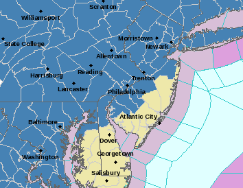
Also, fascinating that NWS-NYC went just with advisories for slightly more snow (5-9" through Friday, but only 3-6" for Thursday), but because it's over 30 hours, as per my comments above. Map of warnings (pink) and advisories (blue) is below; still waiting on the NYC snowfall map.
Area Forecast Discussion
National Weather Service Mount Holly NJ
330 PM EST Wed Feb 17 2021
.SYNOPSIS...
High pressure will shift northeastward into New England tonight. Low
pressure tracking out of the Gulf Coast region will pass just off
the mid-Atlantic coast late Thursday into early Friday before departing
out to sea. Strong high pressure builds into the region over the
weekend. A frontal system approaching from the west will move quickly
through the mid-Atlantic on Monday, and renewed high pressure will
likely build in by the middle of next week.
&&
.NEAR TERM /THROUGH THURSDAY/...
It seems there is never a simple winter-weather event in this part
of the country...
A very complex upper pattern will unfold over the next 24 hours. A
large-scale trough in the Rockies with several embedded
perturbations will progress eastward into the Plains by 00z Friday.
The southern stream will feature one vort max ejecting northeastward
from the southern Plains this evening to the eastern Great Lakes and
Saint Lawrence Valley Thursday night, while shearing in the
confluent midlevel flow downstream. A second southern-stream
shortwave trough will dig from the Desert Southwest to southern
Texas during the same time, which will have impacts on the Thursday
night/Friday period for our area. Meanwhile, two northern-stream
perturbations will race southeastward from the Canadian Rockies to
the Upper Midwest and vicinity.
The ultimate evolution of the first southern-stream perturbation
will be what is responsible for our winter weather late tonight and
Thursday. A strong anticyclonic upper-level jet streak will combine
with midlevel differential cyclonic vorticity advection to aid in
intensifying surface low pressure from the northern Gulf of Mexico
tonight to the Mid-Atlantic coast Thursday afternoon. Intense warm
advection atop a low-level baroclinic zone will aid in widespread
precipitation to the north and northeast of the developing low.
Meanwhile, a strong surface high will remain in southeast Canada,
providing cold onshore flow for the northern Mid-Atlantic preceding
the storm. Models are, as usual, too moist with the predecessor
boundary-layer environment, with dew points a good 6-10+ degrees
lower than model consensus today. This will be important in two
ways. First, it is likely that low-level saturation requirements
will delay precipitation onset in our CWA, with snow not likely to
get going in earnest until near or just after daybreak. Second,
models are likely too warm at the surface, especially during the
main "thump" of precipitation during the morning hours. Sided with
colder guidance here.
With models trending slightly northward with the warm-nose influence
on precipitation type on Thursday, our inclination was to be a
little less aggressive than consensus in this regard. No question
that the strength of warm advection will be intense, likely leading
to a veritable sleet storm in a good chunk of the area as the event
unfolds during the day. However, there has been a tendency for
higher-res guidance to be a little too aggressive in shunting the
warm nose to the north this season. Of course, there has also been a
tendency for northwest shifts in the snow/sleet/freezing rain
geographical distributions within 24 hours of the event (playing out
once again with today's guidance). It will be quite interesting to
see how the 00z solutions play out, as run-to-run variability has
been diminishing confidence in the forecast for this event
considerably.
Adding to the uncertainty here is the highly sensitive nature of the
low-level thermodynamic profiles. Model soundings indicate a rather
deep layer with temperatures close to freezing during precipitation
onset (generally between 900 and 700 mb). The warm nose will be
quite elevated, especially near the urban corridor, which suggests
that sleet will be the primary precipitation type should transition
from the initial burst of snow occur. However, precipitation rates
will be critical in the ultimate evolution of precipitation type,
with models showing such marginal conditions for a long period of
time that it would not surprise us to see variable conditions for
much of the late morning and afternoon hours in a wide sector of the
CWA. Precipitation type may vary from snow to sleet to snow to sleet
in the urban corridor for several hours, with total snow
accumulations quite dependent on the ratio of "snow time" to "sleet
time". Meanwhile, in portions of Delmarva and southern New Jersey,
some mixing with freezing rain and plain rain will likely occur
during the afternoon. Bottom line here: This is incredibly
challenging to forecast in advance and will likely not become clear
until the event is unfolding.
Finally, there is also the "daytime" timing, which is not
particularly favorable for snow accumulations now that we are in the
waning portions of winter. However, the strong lift via
frontogenetical forcing (and strong upper divergence) suggest that
formidable snowfall rates could occur once the heavier snow begins,
with HREF probabilities of 30-50+ percent with snowfall exceeding
one inch per hour in much of the area between 12z and 18z and mean 1-
hour snow accumulations of 0.5-0.75 inches. Should these snow rates
materialize, rapid accumulation would occur despite the unfavorable
diurnal timing.
Weighing all of these factors, hoisted a winter storm warning for
the urban corridor and northwestward and a winter weather advisory
to the southeast, with snow totals generally 4 to 8 inches (higher
amounts northwest of the Fall Line) in the warning and 1 to 4 inches
in the advisory. The warning may end up being quite marginal with
the technical thresholds, but am worried about the initial burst of
precipitation Thursday morning as well as combined effects of
various precipitation types. Some icing may occur in Delmarva and
southern New Jersey, though impacts will likely be mitigated by
marginal surface temperatures. Confidence is quite low in totals
along the I-95 corridor and about 20-40 miles either side, owing to
the precipitation type complications discussed. Precipitation will
likely diminish quickly during the late afternoon as a dry slot
moves into the region, but this sets the stage for round 2 of the
event...
.SHORT TERM /THURSDAY NIGHT THROUGH FRIDAY NIGHT/...
The forecast for Thursday night and Friday is of unusually low
confidence owing to quite disparate deterministic 12z model
solutions regarding southern-stream perturbation number 2. It is
expected that the steadier precipitation from the southern-stream
system impacting us during the day will be to our east Thursday
night. However, low levels will likely remain saturated, leading to
the potential for a lengthy period of light snow (mainly northwest
of the Fall Line) and a light wintry mix farther southeast. In fact,
there may be a lengthy period of freezing drizzle in far southeast
PA, central/southern NJ, and portions of Delmarva. With temperatures
likely continuing below freezing, better ice accretion may occur on
the south side of the winter storm warning and in the winter weather
advisory areas. Thus, have kept the products going through the
morning rush on Friday, despite precipitation rates expected to be
far lower than the daytime Thursday.
The precipitation may linger into the day Friday, but models are all
over the place here, with the NAM basically dry, the GFS/ECMWF
fairly wet, and several hi-res models in between. Basically
implemented consensus for now, and extended the WWAs far enough to
allow for potential extension into more of Friday if required.
Temperatures will likely be flirting with freezing (or higher) in
much of the area southeast of the Fall Line, as well, so it is not
entirely clear where rain versus snow would occur in this scenario.
Last edited:
The weather channel has the snow starting at 6am Thursday going until 7pm Thursday and changing to rain from 7pm until 8pm back to snow at 9 and then back to rain from then until 4am Friday and then snow until 3pm Friday for Jackson
So this looks like a shovel multiple times over the 2 days
So this looks like a shovel multiple times over the 2 days
Similar threads
- Replies
- 62
- Views
- 2K
- Replies
- 608
- Views
- 17K
OT: Minor to Moderate (2-4?) Snowfall Likely Sat morning (2/17); will be <32F, so expect slick roads
- Replies
- 213
- Views
- 5K
- Replies
- 592
- Views
- 15K
- Replies
- 771
- Views
- 20K
ADVERTISEMENT
ADVERTISEMENT