I think that was the best forecast of my life. Hope you all were satisfied regardless of what you wanted.


Colleges
- AAC
- ACC
- Big 12
- Big East
- Big Ten
- Pac-12
- SEC
- Atlantic 10
- Conference USA
- Independents
- Junior College
- Mountain West
- Sun Belt
- MAC
- More
- Navy
- UAB
- Tulsa
- UTSA
- Charlotte
- Florida Atlantic
- Temple
- Rice
- East Carolina
- USF
- SMU
- North Texas
- Tulane
- Memphis
- Miami
- Louisville
- Virginia
- Syracuse
- Wake Forest
- Duke
- Boston College
- Virginia Tech
- Georgia Tech
- Pittsburgh
- North Carolina
- North Carolina State
- Clemson
- Florida State
- Cincinnati
- BYU
- Houston
- Iowa State
- Kansas State
- Kansas
- Texas
- Oklahoma State
- TCU
- Texas Tech
- Baylor
- Oklahoma
- UCF
- West Virginia
- Wisconsin
- Penn State
- Ohio State
- Purdue
- Minnesota
- Iowa
- Nebraska
- Illinois
- Indiana
- Rutgers
- Michigan State
- Maryland
- Michigan
- Northwestern
- Arizona State
- Oregon State
- UCLA
- Colorado
- Stanford
- Oregon
- Arizona
- California
- Washington
- USC
- Utah
- Washington State
- Texas A&M
- Auburn
- Mississippi State
- Kentucky
- South Carolina
- Arkansas
- Florida
- Missouri
- Ole Miss
- Alabama
- LSU
- Georgia
- Vanderbilt
- Tennessee
- Louisiana Tech
- New Mexico State
- Middle Tennessee
- Western Kentucky
- UTEP
- Florida International University
High School
- West
- Midwest
- Northeast
- Southeast
- Other
- Alaska
- Arizona
- California
- Colorado
- Nevada
- New Mexico
- Northern California
- Oregon
- Southern California Preps
- Washington
- Edgy Tim
- Indiana
- Kansas
- Nebraska
- Iowa
- Michigan
- Minnesota
- Missouri
- Oklahoma Varsity
- Texas Basketball
- Texas
- Wisconsin
- Delaware
- Maryland
- New Jersey Basketball
- New Jersey
- New York City Basketball
- Ohio
- Pennsylvania
- Greater Cincinnati
- Virginia
- West Virginia Preps
ADVERTISEMENT
Install the app
How to install the app on iOS
Follow along with the video below to see how to install our site as a web app on your home screen.
Note: This feature may not be available in some browsers.
You are using an out of date browser. It may not display this or other websites correctly.
You should upgrade or use an alternative browser.
You should upgrade or use an alternative browser.
OT: Significant Winter Storm Likely on Thursday (2/18)
- Thread starter RU848789
- Start date

Exactly, childish BS. Way to set the tone “mod”I am rubber, you are glue. Whatever you say bounces off of me and sticks to you.
The funny thing about that line it is grade school level. It will go right over his head because he is just kindergarten level. Maybe next year he'll get it.
Your grammar is kindergarten level, ShortBus.
Thought it was superb. Thought the NWS did quite well also, but your focus on the best forcing and banding being across Mercer, Middlesex and Monmouth and northern Burlington was fantastic. I just wish I hadn't been 10 miles north of the best stuff, as I got 4" snow/sleet, while people just ~10 miles south of me got 6-8" of snow before the sleet came. Although if I had posted it, the usual folks would be calling bust for the parts that were off a bit, lol. I know I'm not a forecaster, but I was pretty happy with my call for my house: 3.5" of snow, then 1" sleet then 1-2" of snow on Friday - got 3" of snow and 1" of sleet today.I think that was the best forecast of my life. Hope you all were satisfied regardless of what you wanted.
By the way, almost every 0Z model right now (globals and mesoscale ones) is showing 1-2" from about 195 to 78 between about 4 am and 4 pm tomorrow and more than 2" north of 78, especially from NYC metro and NE-ward, where most models are showing 2-4". Maybe I can get that 1-2" I was hoping for and maybe the NYC metro and NENJ from Union up to Bergen can verify the 5-8" forecast from the NWS. Most got 3-5" today; Central Park only got 3.2", JFK got 4.3", EWR got 4.0".
A guy on the weather boards who lives in Metuchen and also plows said it was the worst ice he's seen in the past 20 years (he wasn't here in '94) and I might have to agree. So glad I put salt down yesterday after shoveling - even with that there were a few icy patches - and the street in front of my house, which is fairly busy, normally, was empty all night as it was a sheet of ice.
Also, we have Incoming precip, as per the radar clip below. If that batch holds together it looks juicy enough for an inch of snow for many in CNJ, assuming it'll be snow here (it's 29F so it's at least cold enough at the surface and radar indicates it's snow, but maybe sleet south of 195).
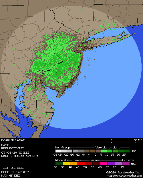
Also, we have Incoming precip, as per the radar clip below. If that batch holds together it looks juicy enough for an inch of snow for many in CNJ, assuming it'll be snow here (it's 29F so it's at least cold enough at the surface and radar indicates it's snow, but maybe sleet south of 195).
Moderate snowfall with huge gorgeous dendrites (for the band name folks, lol)! Should easily get at least an inch from this, judging by the radar.
I'm kind of wishing, now, that I hadn't gone out to clear away all the snow at 5pm yesterday. I now have an unclearable layer of ice everywhere.Moderate snowfall with huge gorgeous dendrites (for the band name folks, lol)! Should easily get at least an inch from this, judging by the radar.
Guess I'll wait and see if we get snow accumulation today, on top of the ice, and clear that off this evening so that the sun and temps above freezing Sat/Sun will hopefully melt away the ice.
That's why I put salt down before the freezing rain hit - I still got some ice in spots, but it was easy to clear it all around midnight and then I put more salt down and the freezing rain overnight didn't really accrete much with the salt down. Our cars on the other hand are encased in ice.I'm kind of wishing, now, that I hadn't gone out to clear away all the snow at 5pm yesterday. I now have an unclearable layer of ice everywhere.
Guess I'll wait and see if we get snow accumulation today, on top of the ice, and clear that off this evening so that the sun and temps above freezing Sat/Sun will hopefully melt away the ice.
My next door neighbor, whose snow I clear, along with the little old lady who lives next to him, was out spreading salt as I was finishing up yesterday before the game. He asked if I wanted him to put it down on my walks, but I declined, not wanting him to over-exert himself.That's why I put salt down before the freezing rain hit - I still got some ice in spots, but it was easy to clear it all around midnight and then I put more salt down and the freezing rain overnight didn't really accrete much with the salt down. Our cars on the other hand are encased in ice.
I would think it'll melt between Saturday and Sunday's sun anyway. But it'll be treacherous to walk on today and overnight, I would imagine.
Moderate snowfall with huge gorgeous dendrites (for the band name folks, lol)! Should easily get at least an inch from this, judging by the radar.
That was a quick 3/4" in about 40-45 minutes (about 1" per hour rates), although it's now just snowing lightly; however the radar shows another band coming in which isn't as big or as heavy looking as this past one, but should be enough to get us to an inch+. Could be treacherous on top of the ice, since people won't see the ice now when walking or driving and this fluff won't stop you from sliding - I know, I almost just fell.
Maybe - if we get 1-2" of snow on top of the ice, that snow will likely melt, but I doubt the underlying ice melts on Saturday, as I'm guessing the melting rate with temps in the low/mid-30s with sun might not be enough for more than the snow on top. The sun will probably get to the ice on Sunday though. Or you could put down some salt, lol.My next door neighbor, whose snow I clear, along with the little old lady who lives next to him, was out spreading salt as I was finishing up yesterday before the game. He asked if I wanted him to put it down on my walks, but I declined, not wanting him to over-exert himself.
I would think it'll melt between Saturday and Sunday's sun anyway. But it'll be treacherous to walk on today and overnight, I would imagine.
We had pretty heavy snow at that time in Belle Mead (Montgomery) - why are you saying no? Radar showed it too - dark blue band.Um no
There was/is a thin fairly heavy band, especially with good snow growth aloft that was hitting the southern 1/4 of Somerset. It put down 1" per hour rates here for awhile and the follow-up band is close to that.Um no
Heavy snow in Hillsborough at 9:45
Brother fight.Um no
I've been meaning to ask you two, do either of you live along Route 523, not too far from Pleasant Run Road? Up near the Round Valley area?
I drive past there a lot, on the way back from some of my long drives up into the northwest mountains. And I noticed a rather prominent display of numerous, large, politically oriented flags along the front of a fairly large property during the month or so leading up to the 2020 elections. Made me think of you, Bac, although from your posts, I believe you live father southeast of Neshanic Station, closer to 206.
It's in the general vicinity of Hillsborough, kind-a, sort-a.
I'll clear any snow that falls on top of it later today. I'm hopeful that exposing the thin layer of ice under, with the snow cleared away, will allow the sunlight to melt the snow. I have no salt, but could ask my neighbor for some. He keeps trying to give me money for clearing snow from his yard which I keep refusing. Gotta take care of our neighbors. WWJD and all.Maybe - if we get 1-2" of snow on top of the ice, that snow will likely melt, but I doubt the underlying ice melts on Saturday, as I'm guessing the melting rate with temps in the low/mid-30s with sun might not be enough for more than the snow on top. The sun will probably get to the ice on Sunday though. Or you could put down some salt, lol.
Went out two days ago to get some more "okay for pets" ice melt, but a few places were all out. I ended up getting two bags of rock salt. Yesterday, I cleared the driveway and then immediately put down the rock salt just as it started icing. I was happy with my timing (thanks to the "morning thump then a break" discussions on this thread). Normally take the dogs out back, so we use the dog-friendly stuff there, as even the backyard gets slippery after walking over the same spots enough times, packing things down. I ended up taking a garden rake and walking it back and forth on the snow a bunch of times to break things up -- seems to have worked okay. Dogs are fine, regardless, just trying to prevent a fall.
We had pretty heavy snow at that time in Belle Mead (Montgomery) - why are you saying no? Radar showed it too - dark blue band.
Because i looked out my window..maybe it lasted two minutes oh
Brother fight.
I've been meaning to ask you two, do either of you live along Route 523, not too far from Pleasant Run Road? Up near the Round Valley area?
I drive past there a lot, on the way back from some of my long drives up into the northwest mountains. And I noticed a rather prominent display of numerous, large, politically oriented flags along the front of a fairly large property during the month or so leading up to the 2020 elections. Made me think of you, Bac, although from your posts, I believe you live father southeast of Neshanic Station, closer to 206.
It's in the general vicinity of Hillsborough, kind-a, sort-a.
Lotta huge MAGA flags in Hillsborough. The one on River Rd continues to be defaced every few months by unhinged dopes
Lotta huge MAGA flags in Hillsborough. The one on River Rd continues to be defaced every few months by unhinged dopes
The run from Whitehouse down to Flemington (523) was filled with them a few months back. To counter that, there is the guy right next to RVCC that had his whole front yard filled with "Blue" and "Anti-Red" stuff. Hopefully we can all go back to hanging out the one flag that matters. RUTGERS!
Snow is essentially over for now and "only" got 1.0" (thought I might get more), which brings us to 5" for the "event" (I think yesterday and today are being counted together). I wonder if the midday almost-late-Feb indirect sun is doing a bit of work on the falling snow, even at 30F. I would expect this 1" to be gone by the end of the afternoon if we get no more snow. Radar shows more snow in SWNJ/SEPA, which will likely make it up here - could be another inch in that if it holds together (short range models are predicting another inch this afternoon for CNJ/NYC/NNJ).That was a quick 3/4" in about 40-45 minutes (about 1" per hour rates), although it's now just snowing lightly; however the radar shows another band coming in which isn't as big or as heavy looking as this past one, but should be enough to get us to an inch+. Could be treacherous on top of the ice, since people won't see the ice now when walking or driving and this fluff won't stop you from sliding - I know, I almost just fell.
Last edited:
The ones on the property I drive past were up for maybe a month - we're talking YUGE flags and about 10-15 of them, at least. It's a big property with a long frontage.Lotta huge MAGA flags in Hillsborough. The one on River Rd continues to be defaced every few months by unhinged dopes
They were taken down almost immediately, within a day or two, of the election, which surprised me given the effort it would've taken to put them up in the first place. No way to know for sure, but I'd suspect the property owner either didn't want to be associated so "loudly" with a loser or maybe didn't want to be associated with a sore loser. Or something. It was weird how quickly they came down, though.
It was obviously a forceful statement putting them up. It appeared to be an equally forceful statement the way they came down so quickly.
True, that road had a lot of political flags. Along the routes I drive, there were lots of them for both candidates prior to the election.The run from Whitehouse down to Flemington (523) was filled with them a few months back. To counter that, there is the guy right next to RVCC that had his whole front yard filled with "Blue" and "Anti-Red" stuff. Hopefully we can all go back to hanging out the one flag that matters. RUTGERS!
I've never been into loudly advertising my affiliations. So no flags of any kind, or magnets for me. Although I do buy and wear RU gear to games.
I will never associate myself with any political party or politician or ideology, not even for friends who've run in local elections like the BoE or town council. I will never fly a political flag or wear a cap or whatever else people do in that regard. I don't worship politicians regardless of any party or ideology affiliation they might have. Other should do as they please. I would feel undignified if I did it, but each to their own.
Numbers although we are
I'm guilty of it too.
Thank you. Isn't it interesting how the NWS made such a big deal about the icing earlier this week, and little mention of it at the end of this storm, and it wound up being fairly significant last night and this am? The "end of storm freezing drizzle after mid levels warm" phenomena is so common and frequently ignored while focus is on "will it be 4-8 or 5-10??!?"Thought it was superb. Thought the NWS did quite well also, but your focus on the best forcing and banding being across Mercer, Middlesex and Monmouth and northern Burlington was fantastic. I just wish I hadn't been 10 miles north of the best stuff, as I got 4" snow/sleet, while people just ~10 miles south of me got 6-8" of snow before the sleet came. Although if I had posted it, the usual folks would be calling bust for the parts that were off a bit, lol. I know I'm not a forecaster, but I was pretty happy with my call for my house: 3.5" of snow, then 1" sleet then 1-2" of snow on Friday - got 3" of snow and 1" of sleet today.
By the way, almost every 0Z model right now (globals and mesoscale ones) is showing 1-2" from about 195 to 78 between about 4 am and 4 pm tomorrow and more than 2" north of 78, especially from NYC metro and NE-ward, where most models are showing 2-4". Maybe I can get that 1-2" I was hoping for and maybe the NYC metro and NENJ from Union up to Bergen can verify the 5-8" forecast from the NWS. Most got 3-5" today; Central Park only got 3.2", JFK got 4.3", EWR got 4.0".
I'm guilty of it too.
Good point. I think it's because the icing was the "only" risk earlier in the week, whereas we had a major risk of 4-8" of snow/sleet for everyone, so they rightly focused on that. However, they did switch the warnings to advisories yesterday late afternoon, including the mention of up to 0.1" of ice accretion, but my guess is they need something which differentiates "advisories" for 2-3" snow vs. for 0.1" of ice. Maybe we need "snow/sleet advisories" and "freezing rain advisories" since the public, I think, kind of ignores advisories vs. warnings, thinking, meh, a few inches of snow. I could be wrong, but this has always been my view on this.Numbers although we are
Thank you. Isn't it interesting how the NWS made such a big deal about the icing earlier this week, and little mention of it at the end of this storm, and it wound up being fairly significant last night and this am? The "end of storm freezing drizzle after mid levels warm" phenomena is so common and frequently ignored while focus is on "will it be 4-8 or 5-10??!?"
I'm guilty of it too.
Lotta huge MAGA flags in Hillsborough. The one on River Rd continues to be defaced every few months by unhinged dopes
They just put up another huge sign...Trump 2024
Um yes. It's over now.
it lasted two minutes
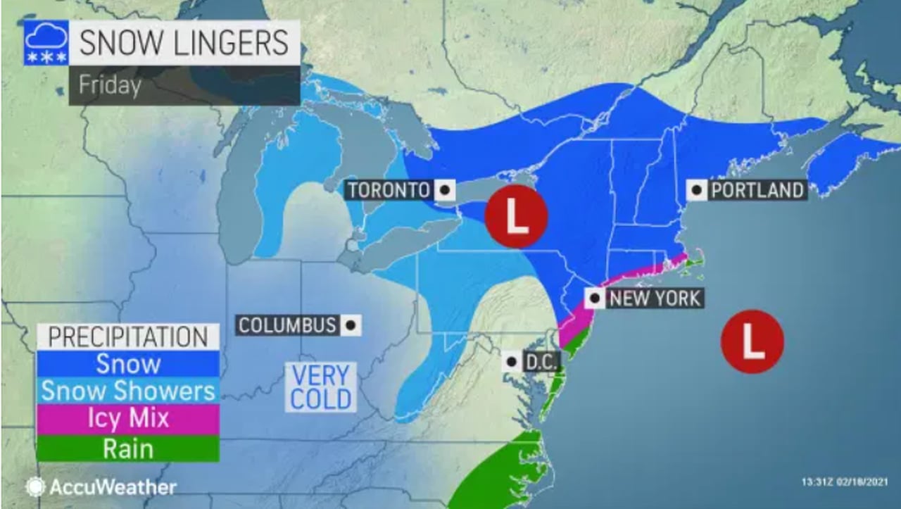
Up to 2 more inches of snow, freezing rain today for N.J.. ‘If it looks wet, assume it’s icy,’ forecasters warn
A winter weather advisory remains in effect for New Jersey. Parts of Mercer, Monmouth, Middlesex and Burlington counties got the most snow on Thursday and another 1-2 inches today could add to some totals.
You got measurable snow today?Snow is essentially over for now and "only" got 1.0" (thought I might get more), which brings us to 5" for the "event" (I think yesterday and today are being counted together). I wonder if the midday almost-late-Feb indirect sun is doing a bit of work on the falling snow, even at 30F. I would expect this 1" to be gone by the end of the afternoon if we get no more snow. Radar shows more snow in SWNJ/SEPA, which will likely make it up here - could be another inch in that if it holds together (short range models are predicting another inch this afternoon for CNJ/NYC/NNJ).
You quoted my post on it and I've been posting about it all morning. 1" new today. More possible later, but not a given.You got measurable snow today?
We had a brief moment of flurries. Nothing on the cars in the parking lot.You quoted my post on it and I've been posting about it all morning. 1" new today. More possible later, but not a given.
+1We had a brief moment of flurries. Nothing on the cars in the parking lot.
Today was a nothing. Time to move on. 40 degrees this week and over 50 degrees next weekend!
+1
Today was a nothing. Time to move on. 40 degrees this week and over 50 degrees next weekend!
Are we officially over this snow cycle we’ve been stuck in over the past few weeks?
And this one:Hopefully we can all go back to hanging out the one flag that matters. RUTGERS!
We got an additional inch on top of what we got last night. Still lightly snowing up here.You got measurable snow today?
Similar threads
- Replies
- 62
- Views
- 2K
- Replies
- 608
- Views
- 17K
OT: Minor to Moderate (2-4?) Snowfall Likely Sat morning (2/17); will be <32F, so expect slick roads
- Replies
- 213
- Views
- 5K
- Replies
- 592
- Views
- 15K
- Replies
- 771
- Views
- 20K
ADVERTISEMENT
ADVERTISEMENT