

Colleges
- AAC
- ACC
- Big 12
- Big East
- Big Ten
- Pac-12
- SEC
- Atlantic 10
- Conference USA
- Independents
- Junior College
- Mountain West
- Sun Belt
- MAC
- More
- Navy
- UAB
- Tulsa
- UTSA
- Charlotte
- Florida Atlantic
- Temple
- Rice
- East Carolina
- USF
- SMU
- North Texas
- Tulane
- Memphis
- Miami
- Louisville
- Virginia
- Syracuse
- Wake Forest
- Duke
- Boston College
- Virginia Tech
- Georgia Tech
- Pittsburgh
- North Carolina
- North Carolina State
- Clemson
- Florida State
- Cincinnati
- BYU
- Houston
- Iowa State
- Kansas State
- Kansas
- Texas
- Oklahoma State
- TCU
- Texas Tech
- Baylor
- Oklahoma
- UCF
- West Virginia
- Wisconsin
- Penn State
- Ohio State
- Purdue
- Minnesota
- Iowa
- Nebraska
- Illinois
- Indiana
- Rutgers
- Michigan State
- Maryland
- Michigan
- Northwestern
- Arizona State
- Oregon State
- UCLA
- Colorado
- Stanford
- Oregon
- Arizona
- California
- Washington
- USC
- Utah
- Washington State
- Texas A&M
- Auburn
- Mississippi State
- Kentucky
- South Carolina
- Arkansas
- Florida
- Missouri
- Ole Miss
- Alabama
- LSU
- Georgia
- Vanderbilt
- Tennessee
- Louisiana Tech
- New Mexico State
- Middle Tennessee
- Western Kentucky
- UTEP
- Florida International University
High School
- West
- Midwest
- Northeast
- Southeast
- Other
- Alaska
- Arizona
- California
- Colorado
- Nevada
- New Mexico
- Northern California
- Oregon
- Southern California Preps
- Washington
- Edgy Tim
- Indiana
- Kansas
- Nebraska
- Iowa
- Michigan
- Minnesota
- Missouri
- Oklahoma Varsity
- Texas Basketball
- Texas
- Wisconsin
- Delaware
- Maryland
- New Jersey Basketball
- New Jersey
- New York City Basketball
- Ohio
- Pennsylvania
- Greater Cincinnati
- Virginia
- West Virginia Preps
ADVERTISEMENT
Install the app
How to install the app on iOS
Follow along with the video below to see how to install our site as a web app on your home screen.
Note: This feature may not be available in some browsers.
You are using an out of date browser. It may not display this or other websites correctly.
You should upgrade or use an alternative browser.
You should upgrade or use an alternative browser.
OT: Snow Thread For Feb 6th & 7th Super Bowl Sunday
- Thread starter Tango Two
- Start date
early reports
Public Information Statement
National Weather Service Mount Holly NJ
1126 AM EST Sun Feb 7 2021
...SNOWFALL REPORTS...
Location Amount Time/Date Provider
...Delaware...
...Kent County...
Dover 1.5 in 1114 AM 02/07 Trained Spotter
...New Castle County...
Glasgow 1.0 in 1048 AM 02/07 Public
...Maryland...
...Caroline County...
Denton 1.0 in 1100 AM 02/07 Trained Spotter
...Kent County...
Millington 0.5 in 0930 AM 02/07 Trained Spotter
...New Jersey...
...Burlington County...
Hainesport 2.0 in 1015 AM 02/07 Trained Spotter
Lumberton 1.0 in 1100 AM 02/07 Trained Spotter
...Camden County...
Cherry Hill 1.0 in 1029 AM 02/07 Public
2 NNE Gibbsboro 0.5 in 1044 AM 02/07 NWS Employee
...Hunterdon County...
White House Station 4.4 in 1105 AM 02/07 Broadcast Media
Readington 4.0 in 1100 AM 02/07 Trained Spotter
Raritan Twp 3.2 in 1015 AM 02/07 Trained Spotter
...Mercer County...
Ewing 3.0 in 1051 AM 02/07 NWS Employee
Hopewell 2.4 in 0930 AM 02/07 Trained Spotter
...Middlesex County...
Edison 3.0 in 1045 AM 02/07 Public
...Morris County...
1 WNW Millington 3.0 in 1037 AM 02/07 Public
Marcella 2.0 in 1030 AM 02/07 Trained Spotter
1 S Mount Arlington 2.0 in 1104 AM 02/07 Cocorahs
Lake Hopatcong 0.9 in 1000 AM 02/07 Trained Spotter
...Somerset County...
Hillsborough Twp 5.0 in 1121 AM 02/07 Public
1 NNE Belle Mead 4.0 in 1031 AM 02/07 Public
1 NW Bridgewater 2.0 in 1000 AM 02/07 Trained Spotter
...Sussex County...
1 W Wantage Twp 0.3 in 1000 AM 02/07 Trained Spotter
...Warren County...
Belvidere 3.0 in 1030 AM 02/07 Public
...Pennsylvania...
...Berks County...
Boyertown 4.5 in 1100 AM 02/07 Trained Spotter
Bechtelsville 3.0 in 0930 AM 02/07 Public
Huffs Church 2.3 in 0930 AM 02/07 Trained Spotter
1 SSW Leesport 1.5 in 1050 AM 02/07 Public
...Bucks County...
Buckingham Twp 8.0 in 1100 AM 02/07 Trained Spotter
Doylestown 7.5 in 1100 AM 02/07 Trained Spotter
Hilltown Twp 7.5 in 1124 AM 02/07 NWS Employee
1 SSW Fricks 7.0 in 1110 AM 02/07
Chalfont 6.7 in 1100 AM 02/07 Trained Spotter
New Hope 5.5 in 1045 AM 02/07 Trained Spotter
Trumbauersville 3.1 in 1121 AM 02/07 Trained Spotter
3 W Jamison 3.0 in 0900 AM 02/07 Public
Langhorne 3.0 in 1100 AM 02/07 Trained Spotter
Perkasie 3.0 in 1012 AM 02/07 Public
Lower Makefield Twp 2.5 in 1017 AM 02/07 Public
Warminster 2.5 in 0955 AM 02/07 Trained Spotter
...Chester County...
West Whiteland Twp 8.8 in 1100 AM 02/07 Public
Phoenixville 6.7 in 1055 AM 02/07 Public
East Nantmeal Twp 6.5 in 1030 AM 02/07 Public
2 S East Whiteland Twp 6.2 in 0945 AM 02/07 Public
1 WNW Uwchlan Twp 6.0 in 1052 AM 02/07 Public
Coatesville 5.5 in 1015 AM 02/07 Public
2 SE Exton 5.5 in 1005 AM 02/07 Trained Spotter
East Brandywine Twp 5.0 in 1011 AM 02/07 Public
Malvern 5.0 in 0951 AM 02/07 Public
Uwchlan Twp 5.0 in 1034 AM 02/07 Public
East Coventry Twp 4.0 in 1044 AM 02/07 Trained Spotter
Parkesburg 4.0 in 0950 AM 02/07 Trained Spotter
Elverson 3.5 in 0915 AM 02/07 Trained Spotter
Jennersville 3.3 in 1005 AM 02/07 Public
Lincoln University 3.0 in 1030 AM 02/07 Trained Spotter
Oxford 3.0 in 0935 AM 02/07 Trained Spotter
West Caln Twp 2.9 in 0900 AM 02/07 Trained Spotter
Landenberg 1.3 in 0950 AM 02/07 Public
...Delaware County...
Thornton 3.1 in 1010 AM 02/07 Trained Spotter
Thornbury Twp 2.2 in 0915 AM 02/07 Trained Spotter
Chadds Ford Twp 2.0 in 0915 AM 02/07 Trained Spotter
...Lehigh County...
Coopersburg 3.5 in 1013 AM 02/07 Public
Macungie 2.4 in 1015 AM 02/07 Trained Spotter
...Montgomery County...
Montgomeryville 6.2 in 1105 AM 02/07 Public
Lansdale 6.0 in 1025 AM 02/07 Trained Spotter
Trappe 5.2 in 1115 AM 02/07 Trained Spotter
Horsham 5.0 in 1020 AM 02/07 Public
Norristown 4.8 in 1105 AM 02/07 Trained Spotter
Skippack 4.5 in 1015 AM 02/07 Trained Spotter
Harleysville 4.0 in 0947 AM 02/07 Public
New Hanover Twp 3.8 in 1030 AM 02/07 Public
3 ESE Sanatoga 3.0 in 1000 AM 02/07 Public
2 ENE Gilbertsville 2.8 in 0930 AM 02/07 Public
Pottstown 2.5 in 0956 AM 02/07 Public
...Northampton County...
Bethlehem 1.8 in 1019 AM 02/07 Public
Lower Mount Bethel Twp 1.4 in 1050 AM 02/07 Trained


Now almost 6.5 and snowing heavy again!5 inches Belle Mead
I want this to end soon so I can shovel out by super bowl
The yellow is going right over my section of Jacksonearly reports
Public Information Statement
National Weather Service Mount Holly NJ
1126 AM EST Sun Feb 7 2021
...SNOWFALL REPORTS...
Location Amount Time/Date Provider
...Delaware...
...Kent County...
Dover 1.5 in 1114 AM 02/07 Trained Spotter
...New Castle County...
Glasgow 1.0 in 1048 AM 02/07 Public
...Maryland...
...Caroline County...
Denton 1.0 in 1100 AM 02/07 Trained Spotter
...Kent County...
Millington 0.5 in 0930 AM 02/07 Trained Spotter
...New Jersey...
...Burlington County...
Hainesport 2.0 in 1015 AM 02/07 Trained Spotter
Lumberton 1.0 in 1100 AM 02/07 Trained Spotter
...Camden County...
Cherry Hill 1.0 in 1029 AM 02/07 Public
2 NNE Gibbsboro 0.5 in 1044 AM 02/07 NWS Employee
...Hunterdon County...
White House Station 4.4 in 1105 AM 02/07 Broadcast Media
Readington 4.0 in 1100 AM 02/07 Trained Spotter
Raritan Twp 3.2 in 1015 AM 02/07 Trained Spotter
...Mercer County...
Ewing 3.0 in 1051 AM 02/07 NWS Employee
Hopewell 2.4 in 0930 AM 02/07 Trained Spotter
...Middlesex County...
Edison 3.0 in 1045 AM 02/07 Public
...Morris County...
1 WNW Millington 3.0 in 1037 AM 02/07 Public
Marcella 2.0 in 1030 AM 02/07 Trained Spotter
1 S Mount Arlington 2.0 in 1104 AM 02/07 Cocorahs
Lake Hopatcong 0.9 in 1000 AM 02/07 Trained Spotter
...Somerset County...
Hillsborough Twp 5.0 in 1121 AM 02/07 Public
1 NNE Belle Mead 4.0 in 1031 AM 02/07 Public
1 NW Bridgewater 2.0 in 1000 AM 02/07 Trained Spotter
...Sussex County...
1 W Wantage Twp 0.3 in 1000 AM 02/07 Trained Spotter
...Warren County...
Belvidere 3.0 in 1030 AM 02/07 Public
...Pennsylvania...
...Berks County...
Boyertown 4.5 in 1100 AM 02/07 Trained Spotter
Bechtelsville 3.0 in 0930 AM 02/07 Public
Huffs Church 2.3 in 0930 AM 02/07 Trained Spotter
1 SSW Leesport 1.5 in 1050 AM 02/07 Public
...Bucks County...
Buckingham Twp 8.0 in 1100 AM 02/07 Trained Spotter
Doylestown 7.5 in 1100 AM 02/07 Trained Spotter
Hilltown Twp 7.5 in 1124 AM 02/07 NWS Employee
1 SSW Fricks 7.0 in 1110 AM 02/07
Chalfont 6.7 in 1100 AM 02/07 Trained Spotter
New Hope 5.5 in 1045 AM 02/07 Trained Spotter
Trumbauersville 3.1 in 1121 AM 02/07 Trained Spotter
3 W Jamison 3.0 in 0900 AM 02/07 Public
Langhorne 3.0 in 1100 AM 02/07 Trained Spotter
Perkasie 3.0 in 1012 AM 02/07 Public
Lower Makefield Twp 2.5 in 1017 AM 02/07 Public
Warminster 2.5 in 0955 AM 02/07 Trained Spotter
...Chester County...
West Whiteland Twp 8.8 in 1100 AM 02/07 Public
Phoenixville 6.7 in 1055 AM 02/07 Public
East Nantmeal Twp 6.5 in 1030 AM 02/07 Public
2 S East Whiteland Twp 6.2 in 0945 AM 02/07 Public
1 WNW Uwchlan Twp 6.0 in 1052 AM 02/07 Public
Coatesville 5.5 in 1015 AM 02/07 Public
2 SE Exton 5.5 in 1005 AM 02/07 Trained Spotter
East Brandywine Twp 5.0 in 1011 AM 02/07 Public
Malvern 5.0 in 0951 AM 02/07 Public
Uwchlan Twp 5.0 in 1034 AM 02/07 Public
East Coventry Twp 4.0 in 1044 AM 02/07 Trained Spotter
Parkesburg 4.0 in 0950 AM 02/07 Trained Spotter
Elverson 3.5 in 0915 AM 02/07 Trained Spotter
Jennersville 3.3 in 1005 AM 02/07 Public
Lincoln University 3.0 in 1030 AM 02/07 Trained Spotter
Oxford 3.0 in 0935 AM 02/07 Trained Spotter
West Caln Twp 2.9 in 0900 AM 02/07 Trained Spotter
Landenberg 1.3 in 0950 AM 02/07 Public
...Delaware County...
Thornton 3.1 in 1010 AM 02/07 Trained Spotter
Thornbury Twp 2.2 in 0915 AM 02/07 Trained Spotter
Chadds Ford Twp 2.0 in 0915 AM 02/07 Trained Spotter
...Lehigh County...
Coopersburg 3.5 in 1013 AM 02/07 Public
Macungie 2.4 in 1015 AM 02/07 Trained Spotter
...Montgomery County...
Montgomeryville 6.2 in 1105 AM 02/07 Public
Lansdale 6.0 in 1025 AM 02/07 Trained Spotter
Trappe 5.2 in 1115 AM 02/07 Trained Spotter
Horsham 5.0 in 1020 AM 02/07 Public
Norristown 4.8 in 1105 AM 02/07 Trained Spotter
Skippack 4.5 in 1015 AM 02/07 Trained Spotter
Harleysville 4.0 in 0947 AM 02/07 Public
New Hanover Twp 3.8 in 1030 AM 02/07 Public
3 ESE Sanatoga 3.0 in 1000 AM 02/07 Public
2 ENE Gilbertsville 2.8 in 0930 AM 02/07 Public
Pottstown 2.5 in 0956 AM 02/07 Public
...Northampton County...
Bethlehem 1.8 in 1019 AM 02/07 Public
Lower Mount Bethel Twp 1.4 in 1050 AM 02/07 Trained
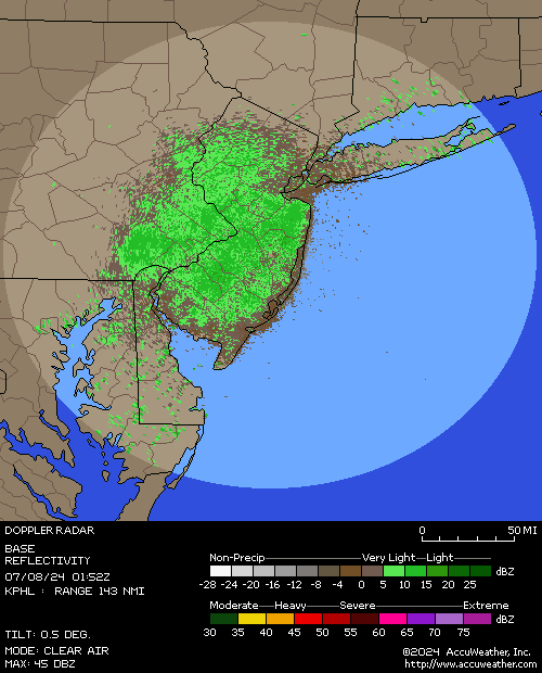
Most locations have switched over to snow this afternoon as the coastal low pulls off to the northeast. Expect another couple hours of snowfall before things wind down from west to east by mid to late afternoon.

4" reported in NW Philly and in NE Philly; haven't seen any reports from the airport or CC. ~3" reported across the river in SNJ.It certainly was a major bust in Center City Philly. On the flip side Bucks County got hammered.
You were predicted to get 2-4 inches of snow - and you have probably 2" more to come.Well so much for my rain or a quick end to this praying. In Howell we blew past 3.5" in no time, with still two hours to go in heavy snow that doesn't seem to be slowing down yet.
You were predicted to get 2-4 inches of snow - and you have probably 2" more to come.

..Connecticut...
...Fairfield County...
2 NNE Norwalk 4.8 in 1230 PM 02/07 Trained Spotter
Monroe 4.5 in 1225 PM 02/07 Trained Spotter
Fairfield 4.5 in 1200 PM 02/07 Public
Norwalk 4.4 in 0100 PM 02/07 Public
2 SW Newtown 4.3 in 1230 PM 02/07 Amateur Radio
Bridgeport Airport 4.2 in 0100 PM 02/07 Official NWS Obs
Stratford 3.8 in 1200 PM 02/07 Public
4 NW Newtown 3.5 in 1245 PM 02/07 Public
Newtown 3.5 in 1230 PM 02/07 Public
1 ENE Norwalk 3.1 in 1115 AM 02/07 Public
1 E Bethel 3.0 in 1215 PM 02/07 Emergency Mngr
2 ENE New Canaan 3.0 in 1110 AM 02/07 Trained Spotter
Weston 2.7 in 1115 AM 02/07 Trained Spotter
Norwalk 1.9 in 1100 AM 02/07 Trained Spotter
...Middlesex County...
Clinton 3.4 in 0100 PM 02/07 Broadcast Media
Chester 3.0 in 1200 PM 02/07 Amateur Radio
Killingworth 3.0 in 1200 PM 02/07 Amateur Radio
...New Haven County...
North Haven 4.6 in 1230 PM 02/07 Trained Spotter
2 N North Haven 4.6 in 1228 PM 02/07 Trained Spotter
Milford 4.0 in 1200 PM 02/07 Amateur Radio
New Haven 3.8 in 1200 PM 02/07 Public
Cheshire 3.5 in 1200 PM 02/07 Public
Wallingford 3.0 in 1200 PM 02/07 Amateur Radio
Woodmont 2.5 in 1200 PM 02/07 Amateur Radio
Branford 2.0 in 1200 PM 02/07 Amateur Radio
...New London County...
Niantic 1.0 in 1200 PM 02/07 Amateur Radio
...New Jersey...
...Bergen County...
Closter 6.8 in 1230 PM 02/07 Public
1 WSW Washington Townshi 6.7 in 0100 PM 02/07 Trained Spotter
1 NNE Westwood 6.5 in 1245 PM 02/07 Public
1 NNE Hillsdale 6.5 in 1215 PM 02/07 Public
Woodcliff Lake 6.1 in 1230 PM 02/07 Trained Spotter
Tenafly 6.1 in 1215 PM 02/07 Public
Rutherford 6.0 in 1245 PM 02/07 Public
East Rutherford 5.9 in 0105 PM 02/07 Trained Spotter
1 N Cliffside Park 5.0 in 1250 PM 02/07 Fire Dept/Rescue
River Vale 4.6 in 1200 PM 02/07 Trained Spotter
New Milford 4.0 in 1145 AM 02/07 Trained Spotter
2 WNW Ramsey 3.8 in 1235 PM 02/07 Trained Spotter
Fair Lawn 3.5 in 1155 AM 02/07 Trained Spotter
Mahwah 2.4 in 1130 AM 02/07 Public
...Essex County...
Cedar Grove 7.7 in 1235 PM 02/07 Public
1 WSW North Caldwell 7.5 in 1250 PM 02/07 Trained Spotter
1 NNE Livingston 6.5 in 1200 PM 02/07 Public
Essex Fells 6.5 in 1130 AM 02/07 Public
West Orange 5.0 in 1110 AM 02/07 Public
...Hudson County...
Harrison 3.5 in 1115 AM 02/07 Trained Spotter
...Passaic County...
Hawthorne 6.1 in 1222 PM 02/07 Trained Spotter
2 NE West Milford 3.2 in 1244 PM 02/07
...Union County...
New Providence 5.9 in 1115 AM 02/07 Trained Spotter
Westfield 5.0 in 1200 PM 02/07 Trained Spotter
Newark Airport 4.0 in 0100 PM 02/07 Official NWS Obs
1 NNE Rahway 4.0 in 1230 PM 02/07 Public
Elizabeth 3.8 in 1110 AM 02/07 Trained Spotter
...New York...
...Bronx County...
1 W East Tremont 2.7 in 1045 AM 02/07 Trained Spotter
Riverdale 1.0 in 1000 AM 02/07 Amateur Radio
...Nassau County...
Glen Cove 4.7 in 1250 PM 02/07 Public
Port Washington 2.3 in 1200 PM 02/07 Public
Syosset 1.5 in 1200 PM 02/07 Public
East Williston 1.3 in 1145 AM 02/07 Public
...New York County...
Central Park 3.0 in 0100 PM 02/07 Official NWS Obs
...Orange County...
Monroe 1.3 in 1150 AM 02/07 Trained Spotter
...Queens County...
1 WNW Jamaica 3.8 in 1230 PM 02/07 Public
Elmhurst 2.2 in 0109 PM 02/07 Trained Spotter
NYC/La Guardia 2.2 in 0100 PM 02/07 Official NWS Obs
Bayside 2.1 in 1115 AM 02/07 Public
Astoria 2.0 in 1130 AM 02/07 Public
...Richmond County...
1 SSW Todt Hill 3.8 in 1200 PM 02/07 Public
Westerleigh 2.1 in 1130 AM 02/07 Public
...Rockland County...
Nyack 2.8 in 1145 AM 02/07 Public
1 NW Stony Point 2.5 in 0100 PM 02/07 Trained Spotter
...Suffolk County...
Babylon 2.0 in 0100 PM 02/07 Trained Spotter
4 ENE Sag Harbor 1.5 in 1245 PM 02/07 Public
Islip Airport 1.3 in 0100 PM 02/07 Official NWS Obs
Upton 1.0 in 0100 PM 02/07 Official NWS Obs
...Westchester County...
Hastings-on-Hudson 6.5 in 1200 PM 02/07 Public
1 NNE New Rochelle 6.0 in 1245 PM 02/07 Public
White Plains 5.6 in 1215 PM 02/07 Trained Spotter
Mount Kisco 3.5 in 1215 PM 02/07 Public
Armonk 3.5 in 1100 AM 02/07 Public
Yonkers 1.0 in 1000 AM 02/07 Amateur Radio
&&
I haven’t gone out to measure yet but it’s gotta be around at least 5 to 6 inches in between Rutherford & E Rutherford and still snowing moderately, enough snow already, I do feel sorry for the people who’s cats are still buried from the big storm, they may need an ice pick to get out.
Public Information Statement
National Weather Service Mount Holly NJ
136 PM EST Sun Feb 7 2021
...SNOWFALL REPORTS...
Location Amount Time/Date Provider
...Delaware...
...Kent County...
Woodside 4.0 in 1258 PM 02/07 Trained Spotter
5 NW Harrington 3.1 in 0100 PM 02/07 Trained Spotter
Dover 2.5 in 1158 AM 02/07 Public
Magnolia 2.5 in 0122 PM 02/07 Public
1 SSE Woodside 2.3 in 1215 PM 02/07 Trained Spotter
...New Castle County...
Middletown 1.5 in 1210 PM 02/07 Public
Glasgow 1.0 in 1048 AM 02/07 Public
New Castle County Airport 0.2 in 0100 PM 02/07 ASOS
...Maryland...
...Caroline County...
Denton 1.0 in 1100 AM 02/07 Trained Spotter
...Kent County...
Millington 0.5 in 0930 AM 02/07 Trained Spotter
...New Jersey...
...Atlantic County...
2 ENE Minotola 2.6 in 1228 PM 02/07 Trained Spotter
Hammonton 2.4 in 1230 PM 02/07 CO-OP Observer
3 SE Egg Harbor Twp 1.0 in 0126 PM 02/07 Public
Mays Landing 1.0 in 1154 AM 02/07 Public
Atlantic City International T in 0100 PM 02/07 ASOS
...Burlington County...
Hainesport 2.5 in 1215 PM 02/07 Trained Spotter
Marlton 2.5 in 0106 PM 02/07 Trained Spotter
Mount Laurel 2.3 in 0100 PM 02/07 Trained Spotter
1 NNW Chesterfield 2.0 in 1225 PM 02/07 Public
Mount Holly WFO 1.9 in 0100 PM 02/07 Official NWS Obs
Lumberton 1.8 in 1200 PM 02/07 Trained Spotter
Burlington 1.5 in 1100 AM 02/07 Trained Spotter
2 SE Jobstown 1.5 in 1200 PM 02/07 Public
...Camden County...
Berlin 3.0 in 0118 PM 02/07 Public
Cherry Hill 2.1 in 1159 AM 02/07 Public
2 NNE Gibbsboro 1.7 in 1230 PM 02/07 NWS Employee
Oaklyn 1.0 in 1233 PM 02/07 Public
Gloucester City 0.9 in 1157 AM 02/07 Trained Spotter
...Gloucester County...
Washington Twp 2.4 in 1230 PM 02/07 Trained Spotter
...Hunterdon County...
White House Station 7.0 in 1233 PM 02/07 Trained Spotter
Flemington 6.0 in 1255 PM 02/07 Public
Lambertville 6.0 in 1100 AM 02/07 Public
Raritan Twp 5.8 in 1145 AM 02/07 Trained Spotter
1 ESE Franklin Twp 5.3 in 1217 PM 02/07 Public
Readington 4.0 in 1100 AM 02/07 Trained Spotter
...Mercer County...
Hopewell 4.9 in 1215 PM 02/07 Trained Spotter
1 W Robbinsville Twp. 4.3 in 0109 PM 02/07 Trained Spotter
Ewing 4.2 in 1230 PM 02/07 NWS Employee
1 S Trenton Mercer Airport 3.0 in 1209 PM 02/07 Trained Spotter
...Middlesex County...
South Plainfield 4.5 in 1200 PM 02/07 Trained Spotter
East Brunswick 4.0 in 1240 PM 02/07 Public
Edison 4.0 in 1250 PM 02/07 Public
2 W Rossmoor 3.8 in 1130 AM 02/07 Public
Carteret 3.0 in 1100 AM 02/07 Trained Spotter
Woodbridge 3.0 in 1128 AM 02/07 Public
Perth Amboy 2.5 in 1120 AM 02/07 Trained Spotter
...Monmouth County...
Keyport 3.5 in 0102 PM 02/07 Trained Spotter
Freehold 3.0 in 0100 PM 02/07 Public
...Morris County...
1 SE Lake Hiawatha 6.2 in 1222 PM 02/07 Trained Spotter
Chatham 6.0 in 1130 AM 02/07 Public
Millington 6.0 in 1136 AM 02/07 Public
1 NE Chatham 5.5 in 1115 AM 02/07 Cocorahs
Randolph 4.0 in 1230 PM 02/07 Trained Spotter
2 E Randolph 4.0 in 1215 PM 02/07 Cocorahs
Montville 3.8 in 1157 AM 02/07 Trained Spotter
Morris Twp 3.8 in 1115 AM 02/07 Trained Spotter
Marcella 3.5 in 1255 PM 02/07 Trained Spotter
2 NNW Rockaway 3.5 in 1214 PM 02/07 Public
Rockaway 3.5 in 1200 PM 02/07 Trained Spotter
Green Pond 3.0 in 1145 AM 02/07 Trained Spotter
Lake Hopatcong 2.3 in 1200 PM 02/07 Trained Spotter
1 S Mount Arlington 2.0 in 1104 AM 02/07 Cocorahs
...Ocean County...
Whiting 2.2 in 1240 PM 02/07 Public
3 W Leisure Village East 1.5 in 1250 PM 02/07 Public
...Somerset County...
Basking Ridge 7.5 in 0107 PM 02/07 Trained Spotter
Warren 6.7 in 1115 AM 02/07 Public
Bridgewater 6.0 in 1250 PM 02/07 Public
Hillsborough Twp 5.0 in 1121 AM 02/07 Public
1 NW Bridgewater 4.5 in 1230 PM 02/07 Trained Spotter
1 NNE Belle Mead 4.0 in 1031 AM 02/07 Public
...Sussex County...
Andover 3.0 in 0125 PM 02/07 Public
1 W Wantage Twp 0.3 in 1000 AM 02/07 Trained Spotter
...Warren County...
Belvidere 3.0 in 1030 AM 02/07 Public
Stewartsville 2.7 in 1130 AM 02/07 Trained Spotter
Marksboro 1.4 in 1200 PM 02/07 Cocorahs
...Pennsylvania...
...Berks County...
Douglassville 4.5 in 1217 PM 02/07 Public
3 ESE Temple 3.5 in 0125 PM 02/07 Trained Spotter
West Wyomissing 3.1 in 1245 PM 02/07 Public
Bechtelsville 3.0 in 0930 AM 02/07 Public
Boyertown 3.0 in 1100 AM 02/07 Public
1 S Shillington 3.0 in 0125 PM 02/07 Trained Spotter
Bern Twp 2.3 in 1200 PM 02/07 Trained Spotter
Huffs Church 2.3 in 0930 AM 02/07 Trained Spotter
1 SSW Leesport 1.5 in 1050 AM 02/07 Public
...Bucks County...
Chalfont 9.3 in 1226 PM 02/07 Trained Spotter
Buckingham Twp 8.2 in 1245 PM 02/07 Public
Hilltown Twp 8.0 in 1257 PM 02/07 NWS Employee
Doylestown 7.6 in 1152 AM 02/07 Public
Furlong 7.4 in 1250 PM 02/07 Trained Spotter
Plumstead Twp 7.1 in 0100 PM 02/07 Trained Spotter
1 SSW Fricks 7.0 in 1110 AM 02/07
3 NNE Horsham Twp 7.0 in 1100 AM 02/07 Public
Lahaska 7.0 in 0127 PM 02/07 Public
2 SW Lumberville 7.0 in 0117 PM 02/07 Public
Perkasie 6.3 in 1145 AM 02/07 Public
Newtown 6.0 in 1258 PM 02/07 Public
1 NE Telford 5.8 in 1122 AM 02/07 Trained Spotter
Solebury Twp 5.5 in 1142 AM 02/07 Public
Warminster 5.5 in 1150 AM 02/07 Public
Langhorne 4.8 in 1247 PM 02/07 Public
Trumbauersville 3.1 in 1121 AM 02/07 Trained Spotter
3 W Jamison 3.0 in 0900 AM 02/07 Public
Lower Makefield Twp 2.5 in 1017 AM 02/07 Public
...Chester County...
Malvern 9.0 in 1159 AM 02/07 Public
1 NNW West Chester 9.0 in 0126 PM 02/07 Public
East Nantmeal Twp 8.8 in 1230 PM 02/07 Public
West Whiteland Twp 8.8 in 1100 AM 02/07 Public
Downington 8.5 in 1100 AM 02/07 Public
2 SSE East Whiteland Twp 8.0 in 1200 PM 02/07 Public
East Coventry Twp 7.0 in 0130 AM 02/07 Trained Spotter
Schuylkill Twp 7.0 in 1130 AM 02/07 Public
Phoenixville 6.7 in 1055 AM 02/07 Public
Coatesville 6.5 in 1245 PM 02/07 Public
1 WNW Uwchlan Twp 6.0 in 1052 AM 02/07 Public
2 SE Exton 5.5 in 1005 AM 02/07 Trained Spotter
East Brandywine Twp 5.0 in 1011 AM 02/07 Public
Uwchlan Twp 5.0 in 1034 AM 02/07 Public
Parkesburg 4.0 in 0950 AM 02/07 Trained Spotter
Elverson 3.5 in 0915 AM 02/07 Trained Spotter
Jennersville 3.3 in 1005 AM 02/07 Public
Lincoln University 3.0 in 1030 AM 02/07 Trained Spotter
Oxford 3.0 in 0935 AM 02/07 Trained Spotter
West Caln Twp 2.9 in 0900 AM 02/07 Trained Spotter
Landenberg 1.3 in 0950 AM 02/07 Public
...Delaware County...
Wayne 6.0 in 1211 PM 02/07 Trained Spotter
Thornton 3.1 in 1010 AM 02/07 Trained Spotter
Thornbury Twp 2.2 in 0915 AM 02/07 Trained Spotter
Chadds Ford Twp 2.0 in 0915 AM 02/07 Trained Spotter
Upper Chichester Twp 1.5 in 0127 PM 02/07 Trained Spotter
Upper Darby 0.8 in 1202 PM 02/07 Public
...Lehigh County...
Center Valley 3.8 in 1251 PM 02/07 Trained Spotter
Coopersburg 3.2 in 1200 PM 02/07 Trained Spotter
Lehigh Valley International 2.7 in 0100 PM 02/07 ASOS
Macungie 2.4 in 1015 AM 02/07 Trained Spotter
...Montgomery County...
Lansdale 8.0 in 1130 AM 02/07 Trained Spotter
Harleysville 7.0 in 1130 AM 02/07 Public
Skippack 6.8 in 1255 PM 02/07 Trained Spotter
Telford 6.5 in 0110 PM 02/07 Trained Spotter
Trappe 6.3 in 1210 PM 02/07 Trained Spotter
Montgomeryville 6.2 in 1105 AM 02/07 Public
Upper Dublin Twp 6.2 in 1230 PM 02/07 Public
Hatboro 6.1 in 1134 AM 02/07 Public
Horsham 6.0 in 1130 AM 02/07 Public
North Wales 6.0 in 1145 AM 02/07 Public
Royersford 6.0 in 1000 AM 02/07 Trained Spotter
3 ESE Sanatoga 5.2 in 1200 PM 02/07 Public
New Hanover Twp 5.0 in 1200 PM 02/07 Public
Oreland 5.0 in 1147 AM 02/07 Public
Norristown 4.8 in 1105 AM 02/07 Trained Spotter
1 W Ambler 4.3 in 1130 AM 02/07 Trained Spotter
Pottstown 4.0 in 1220 PM 02/07 Public
2 ENE Gilbertsville 2.8 in 0930 AM 02/07 Public
...Northampton County...
1 NW Riegelsville 3.2 in 1250 PM 02/07 Public
Bethlehem 1.8 in 1019 AM 02/07 Public
Bushkill Twp 1.8 in 0100 PM 02/07 Trained Spotter
Martins Creek 1.5 in 1200 PM 02/07 Trained Spotter
...Philadelphia County...
1 NNW Philadelphia 1.0 in 1146 AM 02/07 Public
Philadelphia International 0.7 in 0100 PM 02/07 ASOS
&&
Heavy wet snow now
Same. Very sticky when clearing it, kept clogging up my blower. Good for snowmen, though, I guess.
Airport should have a measurement as they were at 36 degrees while CC was at 38 at 6am. The biggest band of the storm was around 7:30 and it was all rain if that was snow that would have been big.4" reported in NW Philly and in NE Philly; haven't seen any reports from the airport or CC. ~3" reported across the river in SNJ.
Philly Airport .7
Wonder if it will be easier to shovel then. I may do that instead of getting the blower out get a workout too. Around 4" here so farSame. Very sticky when clearing it, kept clogging up my blower. Good for snowmen, though, I guess.
As of 12:50 pm, we're up to 5.0" continuing the 1.5"/hr rate, although the intensity just let up after that, while I was doing my 2nd shovel - again, easy with the wide broom. 32F and seeing a bit of melting on paved surfaces that were plowed and have some blacktop, with the midday Feb sun.
At 1:50 pm, we're up to 5.5" as we got 1/2" the past hour. Snow just picked up in intensity, but looks like we're near the end, although I think we'll make it to my prediction of 6" for my house here in Metichen. Still 32F.
You were predicted to get 2-4 inches of snow - and you have probably 2" more to come.
I have much more than 2 inches in Jackson already. I think we have about 4 to 5.
Same. Very sticky when clearing it, kept clogging up my blower. Good for snowmen, though, I guess.
I used the shovel instead. I was out twice already
Airport should have a measurement as they were at 36 degrees while CC was at 38 at 6am. The biggest band of the storm was around 7:30 and it was all rain if that was snow that would have been big.
Philly Airport .7
Someone from the weather boards in Philly said that he's been around Philly today and confirmed far less at the lower elevations of CC and PIA, where much more rain fell. Said in both Philly and Delaware Counties near Philly, there was maybe 1" at/near the river and 4-5" or more 5 miles NW, with elevation. PIA reported 0.7" so far and Media, about 5 miles NW has 5". Crazy. Also some element of the urban heat island effect. I'd be pissed if I lived in Philly, lol.
Jackson was predicted to get 3-5", as it's inland from Howell and distance from the ocean matters, as does where the bands hit...I have much more than 2 inches in Jackson already. I think we have about 4 to 5.
Jackson was predicted to get 3-5", as it's inland from Howell and distance from the ocean matters, as does where the bands hit...
And the town is huge. I am all the way over by Route 537 a good 8 miles from the border with Howell
Biggest measurement between my house and the beer store 4 blocks away(I walked with a tape measure) was a 1/4 inch on my grill. Temp never got below 34 so with that and the very wet conditions nothing stuck after hitting the ground.Someone from the weather boards in Philly said that he's been around Philly today and confirmed far less at the lower elevations of CC and PIA, where much more rain fell. Said in both Philly and Delaware Counties near Philly, there was maybe 1" at/near the river and 4-5" or more 5 miles NW, with elevation. PIA reported 0.7" so far and Media, about 5 miles NW has 5". Crazy. Also some element of the urban heat island effect. I'd be pissed if I lived in Philly, lol.
I'm going to guess Wilmington might post nothing. So a complete whiff again.
However they also missed really low in Upper Bucks. Part of the 1-3" group got 8"
Then you're 8 miles from me as I'm right on the border of Jackson. Have about 4" here. Picked up about a 1/2" in the last hour and one more hour to go. Still coming down heavy.And the town is huge. I am all the way over by Route 537 a good 8 miles from the border with Howell
Had about an inch here but it’s mostly gone already turning to rain
Similar threads
- Replies
- 62
- Views
- 2K
- Replies
- 592
- Views
- 15K
OT: Minor to Moderate (2-4?) Snowfall Likely Sat morning (2/17); will be <32F, so expect slick roads
- Replies
- 213
- Views
- 5K
- Replies
- 608
- Views
- 17K
- Replies
- 771
- Views
- 20K
ADVERTISEMENT
Latest posts
-

-
-
***Ask The Experts Presented by American Financial Network’s Greg Ginn***
- Latest: rutgersspeak95
-

ADVERTISEMENT