As a teacher, nothing pisses me off more than a mid-March snowstorm of any kind. So freakin' close to being able to discount the rest of those snow days. We have 2 left, so losing one day is ok. I do not want the blizzard scenario at all.....for my days off and preserving my back.


Colleges
- AAC
- ACC
- Big 12
- Big East
- Big Ten
- Pac-12
- SEC
- Atlantic 10
- Conference USA
- Independents
- Junior College
- Mountain West
- Sun Belt
- MAC
- More
- Navy
- UAB
- Tulsa
- UTSA
- Charlotte
- Florida Atlantic
- Temple
- Rice
- East Carolina
- USF
- SMU
- North Texas
- Tulane
- Memphis
- Miami
- Louisville
- Virginia
- Syracuse
- Wake Forest
- Duke
- Boston College
- Virginia Tech
- Georgia Tech
- Pittsburgh
- North Carolina
- North Carolina State
- Clemson
- Florida State
- Cincinnati
- BYU
- Houston
- Iowa State
- Kansas State
- Kansas
- Texas
- Oklahoma State
- TCU
- Texas Tech
- Baylor
- Oklahoma
- UCF
- West Virginia
- Wisconsin
- Penn State
- Ohio State
- Purdue
- Minnesota
- Iowa
- Nebraska
- Illinois
- Indiana
- Rutgers
- Michigan State
- Maryland
- Michigan
- Northwestern
- Arizona State
- Oregon State
- UCLA
- Colorado
- Stanford
- Oregon
- Arizona
- California
- Washington
- USC
- Utah
- Washington State
- Texas A&M
- Auburn
- Mississippi State
- Kentucky
- South Carolina
- Arkansas
- Florida
- Missouri
- Ole Miss
- Alabama
- LSU
- Georgia
- Vanderbilt
- Tennessee
- Louisiana Tech
- New Mexico State
- Middle Tennessee
- Western Kentucky
- UTEP
- Florida International University
High School
- West
- Midwest
- Northeast
- Southeast
- Other
- Alaska
- Arizona
- California
- Colorado
- Nevada
- New Mexico
- Northern California
- Oregon
- Southern California Preps
- Washington
- Edgy Tim
- Indiana
- Kansas
- Nebraska
- Iowa
- Michigan
- Minnesota
- Missouri
- Oklahoma Varsity
- Texas Basketball
- Texas
- Wisconsin
- Delaware
- Maryland
- New Jersey Basketball
- New Jersey
- New York City Basketball
- Ohio
- Pennsylvania
- Greater Cincinnati
- Virginia
- West Virginia Preps
ADVERTISEMENT
Install the app
How to install the app on iOS
Follow along with the video below to see how to install our site as a web app on your home screen.
Note: This feature may not be available in some browsers.
You are using an out of date browser. It may not display this or other websites correctly.
You should upgrade or use an alternative browser.
You should upgrade or use an alternative browser.
The OFFICIAL March 13-14 Winter Weather Thread (This is the B1G 1)
- Thread starter Knight Shift
- Start date

12z roundup
3/11 12z
SREF:
NAM: mix to rain - snow : (western most model) / QPF:
PNAM: mix to hvy snow / QPF: 1.25 - 1.50
GFS: Mostly snow / QPF: 1.00 - 1.10 (Snow 6 - 12")
GEFS: mosly snow / QPF: 1.00 - 1.15
GGEM: hvy snow / QPF: 1.10 1.25 (Snow 10" - 18")
UKMET: hvy snow / QPF: N/A)
ECM: snow / QPF: 0.75 - 1.05 (6 - 12")
EPS: hvy snow : QPF: 1.05 - 1.25
60 hours before a storm...you have been around here long enough not to call something a lock...likely yes, lock no and calling for 12-18 is waaaaaaaaay premature especially with your buddy the Euro moving way east
looks like someone jinxed it[banana]
I didn't quite say it was a lock - said 8-12" "looked like a lock," but yeah, maybe a bit premature even to say that. But with decent reasoning IMO. I rarely say something like that with such confidence 60 hours out, but I was probably sucked in by the nearly unprecedented consistency of the Euro (the best model), along with most of the other models looking pretty snowy, as well as an unusually high number of top pros saying similar things. I still think 8-12" is very likely and 12-18" is a good possibility, although maybe not as good as before. I also expect winter storm watches to go up shortly.
I assume you're joking on the jinx thing.
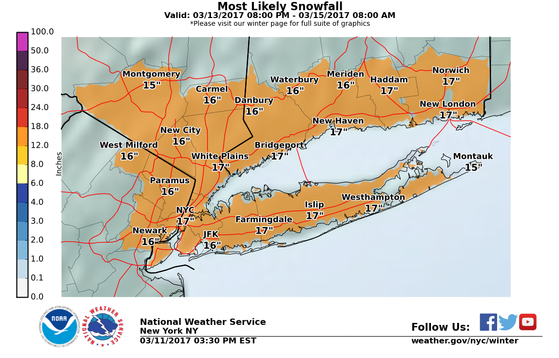
Wow, the NWS in NYC just came out with winter storm watches for everyone and blizzard watches for coastal sections. They're calling for 12-18" of snow for their entire area (NE NJ, NYC, LI, CT, Hudson Valley). And some think I was being too bullish, lol. I must say, I've never ever seen them this bullish this far out on a storm, especially calling for 12-18" 60 hours out. As I said above, I expect NWS Philly to follow suit shortly. And keep in mind, these folks have seen all the same model runs.
http://www.weather.gov/okx/
Edit: here's their snowfall map...
Last edited:
Wow, the NWS in NYC just came out with winter storm watches for everyone and blizzard watches for coastal sections. They're calling for 12-18" of snow for their entire area (NE NJ, NYC, LI, CT, Hudson Valley). As I said above, I expect NWS Philly to follow suit shortly. And keep in mind, these folks have seen all the same model runs.
http://www.weather.gov/okx/
So Upton just jinxed it. The pressure's off of you.
So Upton just jinxed it. The pressure's off of you.
I know, lol. I just added a short edit to the post you quoted. I've never seen any NWS office go that bullish 60 hours out. I can kind of say what I want, really, as can anyone else on a message board, but this is their job, so very surprised to see them go all in so soon, especially with Jan-15 being relatively fresh in mind (although they did much better than Mt. Holly for that storm, as NE NJ got 8-12", NYC got 12-16" and LI/CT got 16-30", which wasn't that far from the forecast).
Can someone translate this to English?12z roundup
3/11 12z
SREF:
NAM: mix to rain - snow : (western most model) / QPF:
PNAM: mix to hvy snow / QPF: 1.25 - 1.50
GFS: Mostly snow / QPF: 1.00 - 1.10 (Snow 6 - 12")
GEFS: mosly snow / QPF: 1.00 - 1.15
GGEM: hvy snow / QPF: 1.10 1.25 (Snow 10" - 18")
UKMET: hvy snow / QPF: N/A)
ECM: snow / QPF: 0.75 - 1.05 (6 - 12")
EPS: hvy snow : QPF: 1.05 - 1.25
12z roundup
3/11 12z
SREF:
NAM: mix to rain - snow : (western most model) / QPF:
PNAM: mix to hvy snow / QPF: 1.25 - 1.50
GFS: Mostly snow / QPF: 1.00 - 1.10 (Snow 6 - 12")
GEFS: mosly snow / QPF: 1.00 - 1.15
GGEM: hvy snow / QPF: 1.10 1.25 (Snow 10" - 18")
UKMET: hvy snow / QPF: N/A)
ECM: snow / QPF: 0.75 - 1.05 (6 - 12")
EPS: hvy snow : QPF: 1.05 - 1.25
You really should copy/paste from another source with an acknowledgement or a link.
KS - QPF is quantitative precipitation forecast - it's the liquid equivalent that will fall as snow and use 10X to get snowfall, i.e., 1.10-1.25" of liquid is about 11-12" of snow. The ones in parentheses are already converted to snow (and in some cases, like the GFS, the rain is subtracted out from the snow amount in parentheses. When I post these from the guy Sacrus on AmericanWx, I usually do the math for folks, since it's confusing.
https://www.americanwx.com/bb/topic/49809-march-13-15-major-winter-storm-potential/?page=20
NWS in Philly followed suit with watches, but was much more conservative, only saying 6" or more of snow is likely.
http://forecast.weather.gov/wwamap/wwatxtget.php?cwa=phi&wwa=winter storm watch
Edit: NWS-Philly finally posted their updated map...
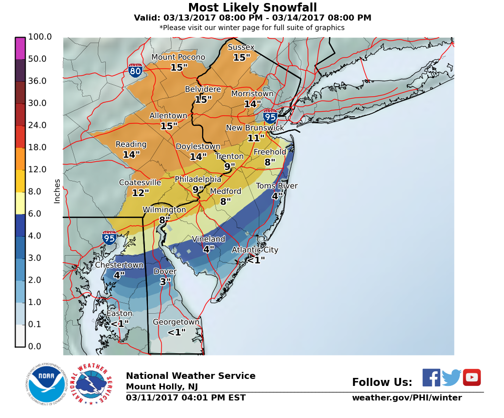
http://forecast.weather.gov/wwamap/wwatxtget.php?cwa=phi&wwa=winter storm watch
Edit: NWS-Philly finally posted their updated map...
Last edited:
Wow, the NWS in NYC just came out with winter storm watches for everyone and blizzard watches for coastal sections. They're calling for 12-18" of snow for their entire area (NE NJ, NYC, LI, CT, Hudson Valley). And some think I was being too bullish, lol. I must say, I've never ever seen them this bullish this far out on a storm, especially calling for 12-18" 60 hours out. As I said above, I expect NWS Philly to follow suit shortly. And keep in mind, these folks have seen all the same model runs.
http://www.weather.gov/okx/
even weenies on americanwx think that was way too premature and bullish in light of the euro and nams thinking
Mt Holly has watches but cautious too
You really should copy/paste from another source with an acknowledgement or a link.
KS - QPF is quantitative precipitation forecast - it's the liquid equivalent that will fall as snow and use 10X to get snowfall, i.e., 1.10-1.25" of liquid is about 11-12" of snow. The ones in parentheses are already converted to snow (and in some cases, like the GFS, the rain is subtracted out from the snow amount in parentheses. When I post these from the guy Sacrus on AmericanWx, I usually do the math for folks, since it's confusing.
https://www.americanwx.com/bb/topic/49809-march-13-15-major-winter-storm-potential/?page=20
please..its a post from a poster on american wx, he gathered up the info that was out there, board police much....ooooooh

just in NAM snowmap

I thought you didn't like people posting model maps? Hmmmmm. At least I gave a paragraph of caveats when I did it the other day, as opposed to just leaving it here without any context. I'm sure it's coincidence that you only posted the model with the least snow - if you wanted to be balanced, you'd post the Euro Ensemble Mean, which shows 12-18" area wide.
So Upton just jinxed it. The pressure's off of you.
Upton must be on beaners to call that so early especially with a little uncertainty in the afternoon models...I mean geez start with 8-12 and move from there...we have 60 hours to sort it out
Mt Holly more responsible albeit they need to be because part of their area could see just rain
I thought you didn't like people posting model maps? Hmmmmm. At least I gave a paragraph of caveats when I did it the other day, as opposed to just leaving it here without any context. I'm sure it's coincidence that you only posted the model with the least snow - if you wanted to be balanced, you'd post the Euro Ensemble Mean, which shows 12-18" area wide.
just showing what the maps show....people can read. Its not a forecast but certainly more relevant than putting up a Kuchera map showing 28 inches on a storm 8 days away. Its not like you would be discussing the NAM anyhow
Get people to be better prepared in case it happens????Upton must be on beaners to call that so early especially with a little uncertainty in the afternoon models...I mean geez start with 8-12 and move from there...we have 60 hours to sort it out
Mt Holly more responsible albeit they need to be because part of their area could see just rain

just showing what the maps show....people can read. Its not a forecast but certainly more relevant than putting up a Kuchera map showing 28 inches on a storm 8 days away. Its not like you would be discussing the NAM anyhow
Please - you usually focus on the least snowy scenario - that's why you piss off everyone on AmericanWx and got 5-posted a few times. I talked all about the bad Euro run and the NAM in my posts above - I try to provide balance. Even @camdenlawprof called you out on it yesterday. And there's nothing wrong with Kuchera maps if you know their limitations - they're no more biased than the 10:1 ratio maps.
actually I wasnt 5 posted, that was some sort of mistake/joke. Mods told me as much
actually I am trying to provide balance here. I post pretty much all the solutions good or bad. You were already calling a lock on 8-12...which could happen and we could get more but emphasize on could...nothing is a lock since we have seen a plethora of busted storms, especially 60 hours out
actually I am trying to provide balance here. I post pretty much all the solutions good or bad. You were already calling a lock on 8-12...which could happen and we could get more but emphasize on could...nothing is a lock since we have seen a plethora of busted storms, especially 60 hours out
I've never had a different screen name - What is your point? Do you think calling guessed Tuesday storm amounts a "lock" on Saturday is legitimate/useful?What was your previous screen name?
12z roundup
3/11 12z
SREF:
NAM: mix to rain - snow : (western most model) / QPF:
PNAM: mix to hvy snow / QPF: 1.25 - 1.50
GFS: Mostly snow / QPF: 1.00 - 1.10 (Snow 6 - 12")
GEFS: mosly snow / QPF: 1.00 - 1.15
GGEM: hvy snow / QPF: 1.10 1.25 (Snow 10" - 18")
UKMET: hvy snow / QPF: N/A)
ECM: snow / QPF: 0.75 - 1.05 (6 - 12")
EPS: hvy snow : QPF: 1.05 - 1.25
TWELVE ZEEE O^Can someone translate this to English?
THREE slash ELEVEN TWELVE ZEEE
ect... ect..
Hope that helps
So, the 18Z NAM and GFS both underwhelming with the NAM showing lots of mixing/rain up through I-95 and a lot of snow NW of there (10-16"), while the GFS has a great track, but simply looks less dynamic with "only" 8-12" for most of the area (only rain down by AC). Still not sure why the NWS put out such bullish snowfall forecasts, especially the 12-18" for NWS-NYC (NE NJ, NYC, LI, CT), when they could've put out the watches with 8-14" or so, which gets the point across without having to backtrack.
I thought the coast was getting more than what it shows on the National Weather Service map.
Not in the know but I'd guess it has something to do with a rain/sleet/snow mix during the late morning - early aft.
Some/most models showing enough warm air at the coast to turn the snow to rain - not unusual in major east coast snowstorms. Biggest variance in the outcome is likely to be at the shore, where anywhere from 2-20" could theoretically fall.I thought the coast was getting more than what it shows on the National Weather Service map.
Yup gfs cuts totals to 6-12....tonights runs huge to see if trend is developing. .models shifting is nothing unusual..that is why caution is always advised in any confidence of something days in advance
Some/most models showing enough warm air at the coast to turn the snow to rain - not unusual in major east coast snowstorms. Biggest variance in the outcome is likely to be at the shore, where anywhere from 2-20" could theoretically fall.
Ain't it the truth. My concern usually isn't snow total, it's flooding with the high tide cycle.
2" will be a theoretical fail, and bac will be all over you for it. I'll give you :fistbump::fistbump: if we get 2" here.Some/most models showing enough warm air at the coast to turn the snow to rain - not unusual in major east coast snowstorms. Biggest variance in the outcome is likely to be at the shore, where anywhere from 2-20" could theoretically fall.
And models showing warm air usually results in much more than 2".Some/most models showing enough warm air at the coast to turn the snow to rain - not unusual in major east coast snowstorms. Biggest variance in the outcome is likely to be at the shore, where anywhere from 2-20" could theoretically fall.
Talking to snow plow buddies. Trending downward. What happens if 2 lows don't merge and we just get snow showers? Anyone remember March 3/4 time frame four years ago we were predicted for a monstrous 2 feet and we ended up with flurries.
Yet when he does the same thing you bicker with him like a little girl.just showing what the maps show....people can read.
I'm trying to find anything useful or Rutgers related that you've ever posted: so far all I find is you bitching in the weather threads.I've never had a different screen name - What is your point? Do you think calling guessed Tuesday storm amounts a "lock" on Saturday is legitimate/useful?
Good for you - amazing how my comments bother you so much that you actually took the time to look up my posting history. Must not have much else to do? Fact is that talking in absolutes 3 days out is pretty silly and I just stated that. Sorry it that is too much for you to handle...Yet when he does the same thing you bicker with him like a little girl.
I'm trying to find anything useful or Rutgers related that you've ever posted: so far all I find is you bitching in the weather threads.
Umm, he is a moderator, and that's what moderators do?Good for you - amazing how my comments bother you so much that you actually took the time to look up my posting history. Must not have much else to do? Fact is that talking in absolutes 3 days out is pretty silly and I just stated that. Sorry it that is too much for you to handle...
Talking to snow plow buddies. Trending downward. What happens if 2 lows don't merge and we just get snow showers? Anyone remember March 3/4 time frame four years ago we were predicted for a monstrous 2 feet and we ended up with flurries.
March 2001 was the biggest bust of all time...everyone knew it wasnt happening a day before but mets were still so slow to change their forecast including Bolaris who got hate mail and then canned
Yet when he does the same thing you bicker with him like a little girl.
I'm trying to find anything useful or Rutgers related that you've ever posted: so far all I find is you bitching in the weather threads.
um no I just roll my eyes at why putting a snow map out 7 days before an event
WTF is wrong with so many of the posters on this message board? As I go through not just this thread but many threads, the majority have divisiveness and bickering beyond belief. If you don't want to read someone just use ignore rather than attacking. Almost unreadable.
WTF is wrong with so many of the posters on this message board? As I go through not just this thread but many threads, the majority have divisiveness and bickering beyond belief. If you don't want to read someone just use ignore rather than attacking. Almost unreadable.
Think of it like watching the WWE doing the weather.

Similar threads
- Replies
- 477
- Views
- 12K
- Replies
- 608
- Views
- 17K
- Replies
- 62
- Views
- 2K
- Replies
- 104
- Views
- 2K
- Replies
- 771
- Views
- 20K
ADVERTISEMENT
ADVERTISEMENT