

Colleges
- AAC
- ACC
- Big 12
- Big East
- Big Ten
- Pac-12
- SEC
- Atlantic 10
- Conference USA
- Independents
- Junior College
- Mountain West
- Sun Belt
- MAC
- More
- Navy
- UAB
- Tulsa
- UTSA
- Charlotte
- Florida Atlantic
- Temple
- Rice
- East Carolina
- USF
- SMU
- North Texas
- Tulane
- Memphis
- Miami
- Louisville
- Virginia
- Syracuse
- Wake Forest
- Duke
- Boston College
- Virginia Tech
- Georgia Tech
- Pittsburgh
- North Carolina
- North Carolina State
- Clemson
- Florida State
- Cincinnati
- BYU
- Houston
- Iowa State
- Kansas State
- Kansas
- Texas
- Oklahoma State
- TCU
- Texas Tech
- Baylor
- Oklahoma
- UCF
- West Virginia
- Wisconsin
- Penn State
- Ohio State
- Purdue
- Minnesota
- Iowa
- Nebraska
- Illinois
- Indiana
- Rutgers
- Michigan State
- Maryland
- Michigan
- Northwestern
- Arizona State
- Oregon State
- UCLA
- Colorado
- Stanford
- Oregon
- Arizona
- California
- Washington
- USC
- Utah
- Washington State
- Texas A&M
- Auburn
- Mississippi State
- Kentucky
- South Carolina
- Arkansas
- Florida
- Missouri
- Ole Miss
- Alabama
- LSU
- Georgia
- Vanderbilt
- Tennessee
- Louisiana Tech
- New Mexico State
- Middle Tennessee
- Western Kentucky
- UTEP
- Florida International University
High School
- West
- Midwest
- Northeast
- Southeast
- Other
- Alaska
- Arizona
- California
- Colorado
- Nevada
- New Mexico
- Northern California
- Oregon
- Southern California Preps
- Washington
- Edgy Tim
- Indiana
- Kansas
- Nebraska
- Iowa
- Michigan
- Minnesota
- Missouri
- Oklahoma Varsity
- Texas Basketball
- Texas
- Wisconsin
- Delaware
- Maryland
- New Jersey Basketball
- New Jersey
- New York City Basketball
- Ohio
- Pennsylvania
- Greater Cincinnati
- Virginia
- West Virginia Preps
ADVERTISEMENT
Install the app
How to install the app on iOS
Follow along with the video below to see how to install our site as a web app on your home screen.
Note: This feature may not be available in some browsers.
You are using an out of date browser. It may not display this or other websites correctly.
You should upgrade or use an alternative browser.
You should upgrade or use an alternative browser.
The OFFICIAL March 13-14 Winter Weather Thread (This is the B1G 1)
- Thread starter Knight Shift
- Start date
Yes the Euro flipped to a huge hit last night and the nam followed suit 12-24 inches throughout the region.....however if you hate snow root for the GFS which this morning continues to be the outlier with only 4-8 inches
Todays runs will be huge for honing in on a concise forecast and by tomorrow morning should have the details laid out at a confident level. With possible coastal flooding and high winds and wet snow possibly causing dangerous power outages lets just all hope for a shift to less snowier solutions
Todays runs will be huge for honing in on a concise forecast and by tomorrow morning should have the details laid out at a confident level. With possible coastal flooding and high winds and wet snow possibly causing dangerous power outages lets just all hope for a shift to less snowier solutions
This storm, is really going to impact the local baseball and softball practices and scrimmage games for some time. Fields will be a mess for I'd bet 10 days, at least.
TmiSaw 10-18 inches this morning.

Now THAT'S a lock.Some of you people must be a joy to live with.
Surprised. usually he likes to go to Plymouth, and hang out by the East Bay Grill. Don't blame him. My daughter lives a mile away,and the place is good .Somebody just posted on AMWx that Jim Cantore is on his way to New York.
Kiss of death. Storm cancel.
That's what she saidSaw 10-18 inches this morning.
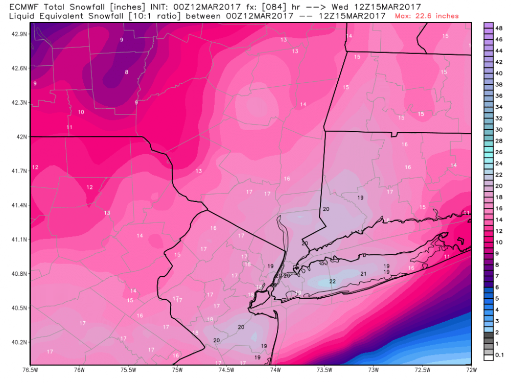
Here was last nights Euro run to refute Numbers claim I only post maps that show the least amount.
so the 12z NAM just came in and cut qpf to .75-1...thats a 6-12 inch type storm at all snow, would have serious mixing issues south of 95 to the coast. Also a more progressive storm, much faster over in 10-12 hours. Area never gets into the CCB...cold conveyour belt
Para and 3K NAM are more heavier with its snows
Para and 3K NAM are more heavier with its snows
My hermit crabs are pretty quiet. When a big storm approaches they start creating havoc moving empty shells and turning over fed dish and water.
...
To think TV meteorologists get paid major bucks when all we really need is your hermit crabs. Hope they stay calm the next two daysMy hermit crabs are pretty quiet. When a big storm approaches they start creating havoc moving empty shells and turning over fed dish and water.
With others I'd also like to see less fighting but that doesn't diminish my appreciation to #'s, Bac, and others who contribute to our understanding of what's going on.
I meant it in the nicest way, that you're one of the most dispassionate, logical, level-headed posters we have, who rarely criticizes anyone, so when you made the comment you made, it has very high credibility.
That's a very nice thing to say, To be honest, sometimes it is quite a strain to be "level-headed" around here.
Now, boys... Let us remember the words of the great Winston Wolf.
Saw 10-18 inches this morning.
Is that expected to come your way on Tuesday?
Like Ty Webb, I would also be interested in learning about the Cherry Hill area. My impression is contrary to Ty's: that the Jersey suburbs of Philadelphia are going to get hit, and that the rain snow line will be just west and north of Cape May.
BTW, I don't want to criticize Bac too much. I do think that "looks like a lock" was an overstatement -- the models might have all turned out to be wrong -- and Bac's been providing good info in the last couple of hours. I think it's his tone that gets to me more than his substance; And I always try to read his sports postings very carefully; I don't always agree with him, but he often makes very sound points.
BTW, I don't want to criticize Bac too much. I do think that "looks like a lock" was an overstatement -- the models might have all turned out to be wrong -- and Bac's been providing good info in the last couple of hours. I think it's his tone that gets to me more than his substance; And I always try to read his sports postings very carefully; I don't always agree with him, but he often makes very sound points.
12z GFS is in.....okay what the GFS continues to do is that it seems to want to jump alot of the precip off the coast towards offshore convection as it moves the low towards our area which cuts our totals back. It was a littler closer to the coast this time...verbatim its 8-12 inches
12z GFS is in.....okay what the GFS continues to do is that it seems to want to jump alot of the precip off the coast towards offshore convection as it moves the low towards our area which cuts our totals back. It was a littler closer to the coast this time...verbatim its 8-12 inches
And the weenies are saying to "toss it". Lol.
I think we see a solution in between the gfs and others.
Like Ty Webb, I would also be interested in learning about the Cherry Hill area. My impression is contrary to Ty's: that the Jersey suburbs of Philadelphia are going to get hit, and that the rain snow line will be just west and north of Cape May.
BTW, I don't want to criticize Bac too much. I do think that "looks like a lock" was an overstatement -- the models might have all turned out to be wrong -- and Bac's been providing good info in the last couple of hours. I think it's his tone that gets to me more than his substance; And I always try to read his sports postings very carefully; I don't always agree with him, but he often makes very sound points.
my point was just models are always changing. Numbers is going to probably be right but have to wait until closer to the event to be that confident
anyhow your area could do just as well as the rest of us depending on the model...NWS and Mt Holly seems to have you in the heavy amounts so unless the NAM solutions verify and get warmer cutting back totals in south jersey, you shouldnt be too far off from the rest of us although not expected to be in the sweet spot.
Like Ty Webb, I would also be interested in learning about the Cherry Hill area. My impression is contrary to Ty's: that the Jersey suburbs of Philadelphia are going to get hit, and that the rain snow line will be just west and north of Cape May.
BTW, I don't want to criticize Bac too much. I do think that "looks like a lock" was an overstatement -- the models might have all turned out to be wrong -- and Bac's been providing good info in the last couple of hours. I think it's his tone that gets to me more than his substance; And I always try to read his sports postings very carefully; I don't always agree with him, but he often makes very sound points.
I thought it would be interesting to people to see the 5 a.m. NWS briefing. That goes a long way toward answering the question Ty Webb and I had about South Jersey, but I think it might be helpful to people elsewere.
http://www.weather.gov/media/phi/current_briefing.pdf
And the weenies are saying to "toss it". Lol.
I think we see a solution in between the gfs and others.
Yeah the pros and mets will use model blends...you have NAM/GFS in the 6-12 range although the NAM is warmer and the GFS colder so different solutions...then you have the Canadian, RGEM and Euro on board for 12-20 snows.....probably comes down to how fast the storm moves and does is slow or stall a bit and the CCB gives us additional heavier snows. Its probably pretty safe to say we are getting 6-20 inches of snow....its the pros job to figure out the details of and narrow those amounts down for locations
Is the main question right now whether or not it gets close enough to the coast to change parts of NJ to rain for a while, or is there still a chance it goes further east and the entire region underperforms the earlier models?
I am in the Lehigh Valley and it seems like everything I am looking at is at least 6-10 for here.
I am in the Lehigh Valley and it seems like everything I am looking at is at least 6-10 for here.
It's frustrating that Mount Holly is still only updating their snow maps every 12 hours, even with the possibility of a major storm 36 hours out, and the models flopping around. Upton updated around noon. This may be why they went with blizzard warnings so early, to change the schedule of product releases to keep everyone more informed.
Kind of repeating the post above. Very positive trends for a big snowstorm on the 0Z models tonight for the Philly-NYC corridor and the rest of NJ, eastern PA, NYC/LI/Hudson Valley/CT. Looking like the NWS-NYC forecasts of 12-18" for the NYC Metro are reasonable and the 8-12" forecast for I-95 and 12-16" NW of there in NJ/PA (with 4-8" at the immediate coast) by the NWS in Philly are in pretty good shape and are probably underdone, even.
Might see blizzard watches extended to the NJ coastal counties. Still 48 hours from the start of the storm, but this is near consensus on a major to historic snowstorm with just the one outlier (the NAM - and even that's a major snowstorm from the NJ TPK and NW of there).
Doesn't mean things still can't go south, but the models get more and more accurate as the event nears. In addition, it's very important to note that this was, by far, the best set of input data ingested into the models, as the NHC flew some data gathering flights and more balloons were sent up, plus, most importantly, one of the major players, was finally over land for these model runs, meaning the initial condition data were much more complete for that feature, all of which should have improved the accuracy of the model runs.
Edit at 7:45 am to include updated NWS maps; Mt. Holly increased snowfall across the board, especially near the coast where less mixing/rain is now expected. NWS-NYC had no major changes - still 12-18" everywhere.
- NAM is the only iffy model, with rain making it to I-95, keeping accumulations down to 6-10" w/10-18" NW of there and 2-6" towards the coast.
- However, the 3km-Para-NAM (higher resolution) gives a general 8-12" for almost everyone (except far SE NJ), although the model only goes out to 60 hours (7 am Tuesday) and it's still snowing well at that point, so maybe 10-15".
- GFS looks better than earlier today, with a general 8-14" for the entire area.
- The CMC (Canadian) is a "Mother of God" storm with 18-30" area-wide - an all out blizzard for many. This is the potential this storm has - can't be sure for awhile if that will be realized though.
- The RGEM (Canadian mesoscale, shorter term model, like the US NAM) shows a general 8-14".
- The UK is like the CMC with 15-25" of snow area wide.
- And the Euro is also 15-25" area wide; some mixing/rain south of Toms River, but still a big hit.


Had Sunday morning soccer, then brunch with the family and just caught up on the 12Z models. Based on what I've seen, I see no reason to change the thinking on this storm, as the NWS maps look good to me vs. the 12Z models. Pretty good consensus for 10-16" in almost all of the Philly-NYC corridor, except a bit less along the immediate coast south of maybe Toms River (and with only AC to Cape May maybe being under 6").
We're still 36 hours out, so it's still possible one of the outlier solutions could verify and most of us get "only" 6-10", but it's also just as possible that one of the snowy outliers verifies with 14-24". On the lower side, there's the NAM with only 6-10" due to mixing up to I-95, but countered by hi-res NAM showing 10-18", or the GFS showing 8-12" due to less precip (but pros thinking convective feedback issues with the model, which is a known issue). And on the higher side (14-24") there's the UK, CMC and RGEM, which are better models. Euro comes out at 2 pm today, due to us being on EDT now.
The other thing we won't know until the storm is underway is where the heaviest convective mesoscale bands will set up and move around to. These bands are usually oriented parallel to the NE path of the storm, i.e., from SW to NE (typically 20-30 miles from SE to NW by 50-60 miles from SW to NE). Even if the general area got 10-16", areas under 3-4" per hour rates for an hour or two could get 16-24" relatively easily. So, hopefully you can stay at home and enjoy the storm, but if you have to go out, please be careful and be prepared in case you get stuck. And by the way, TWC (on TV - they're gotten way better and were the only ones who called the Jan-15 bust correctly ahead of time by 12 hours) and DT/WxRisk forecasts are consistent with a general 10-16" of snowfall area-wide.
2 pm edit: The 12Z Euro is out and is looking snowy, still - waiting on details. By the way, if the CMC/UK models verify verbatim, we're actually talking about 20-30" of snow just about for the entire area (with the lesser amounts towards Philly and the greater amounts towards NYC).
Last edited:
It's frustrating that Mount Holly is still only updating their snow maps every 12 hours, even with the possibility of a major storm 36 hours out, and the models flopping around. Upton updated around noon. This may be why they went with blizzard warnings so early, to change the schedule of product releases to keep everyone more informed.
Upton's update made almost no changes and the NWS usually only updates more than twice a day if some major change is seen in the models or the system evolution in real time and that's not the case here - sure there's some changes in some models, as always happens, but the consensus of the models if one did a blend hasn't really changed since last night (see my latest post).
If they started updating every time a model run changed, they'd be updating constantly. They also have access to information we don't on model diagnostics and have a lot more knowledge of how the synoptic setup and the conditions at the mid and upper levels will affect the outcome at the surface, so they often will discount some models and blend results from what they think are the best 2-3 models that run and they'll often discuss that in their detailed area forecast discussions.
@RU848789 thank you for the great updates. Much appreciated!
Is the main question right now whether or not it gets close enough to the coast to change parts of NJ to rain for a while, or is there still a chance it goes further east and the entire region underperforms the earlier models?
I am in the Lehigh Valley and it seems like everything I am looking at is at least 6-10 for here.
Yes, an "escape" to the east is still possible, which would leave the Lehigh Valley with only a few inches of snow. It's very unlikely, but one can't ever say "never" in meteorology about a credible, but low probability solution. And a track right along the coast, bringing snow then rain to the I-95 corridor and coast is similarly very unlikely but still possible - that would likely be the snowiest scenario for the LV with 18"+ possible. Right now most models and the NWS forecast would suggest 8-14" in the LV.
So what's the latest for the Philly suburbs in NJ such as Cherry Hill/Evesham Township? Has the recent models shifted south? Last night it was looking like we were on the cut line between mix and snow.
I grew up in Washington Twp and my dad lived for many years in Cherry Hill, so I know the area very well. Used to kill me as a kid hearing, so many times, "1-2", then changing to rain from Philly south and east, but 4-8" in the northern and western suburbs of Philly." Anyway, you guys should be in the 8-12" range if things go as expected, but you're obviously at more risk of mix/rain than NB, Somerville or Trenton (but about the same risk as Freehold or Long Branch) - track is critical obviously. You'll likely start as snow and get several inches no matter what, but keep an eye on the Intellicast radar (Doppler style) that can differentiate rain from snow and see if the rain/snow line starts moving towards you. If it gets to you guys, then we'll need to worry up in the NB area.
And actually, it's much more likely to change to sleet first, with a warm nose at a few thousand feet melts the falling snow and then those water drops refreeze as they fall through at least several hundred feet of sub-32F air near the surface. Sleet shows up very brightly on the radar, too. In the March 1993 Superstorm, the whole I-95 corridor got 8-14" of snow and then 2-6" of sleet, depending on how far inland you were, but it never went all the way over to rain. Could see that in some spots with this storm, especially near the coast.
Last edited:
I meant it in the nicest way, that you're one of the most dispassionate, logical, level-headed posters we have, who rarely criticizes anyone, so when you made the comment you made, it has very high credibility.
A "strain"? Try "nearly impossible". One of the reasons 3 people always ended up being banned from the weather threads last season.That's a very nice thing to say, To be honest, sometimes it is quite a strain to be "level-headed" around here.
The NWS has the snow falling in a window starting at 8 p.m. Monday night. Following this board has convinced me that it is almost impossible to say with any certainty when a storm will start. I am really hoping it does not start before then; it nothing else, that will make the Monday evening commute doable.
Similar threads
- Replies
- 477
- Views
- 12K
- Replies
- 608
- Views
- 17K
- Replies
- 62
- Views
- 2K
- Replies
- 104
- Views
- 2K
- Replies
- 771
- Views
- 20K
ADVERTISEMENT
ADVERTISEMENT