yeah thats from weather.gov, ive never seen it before, too bad it doesnt zoom in on the area but i guess its just like the Mt Holly map only prettier


Colleges
- AAC
- ACC
- Big 12
- Big East
- Big Ten
- Pac-12
- SEC
- Atlantic 10
- Conference USA
- Independents
- Junior College
- Mountain West
- Sun Belt
- MAC
- More
- Navy
- UAB
- Tulsa
- UTSA
- Charlotte
- Florida Atlantic
- Temple
- Rice
- East Carolina
- USF
- SMU
- North Texas
- Tulane
- Memphis
- Miami
- Louisville
- Virginia
- Syracuse
- Wake Forest
- Duke
- Boston College
- Virginia Tech
- Georgia Tech
- Pittsburgh
- North Carolina
- North Carolina State
- Clemson
- Florida State
- Cincinnati
- BYU
- Houston
- Iowa State
- Kansas State
- Kansas
- Texas
- Oklahoma State
- TCU
- Texas Tech
- Baylor
- Oklahoma
- UCF
- West Virginia
- Wisconsin
- Penn State
- Ohio State
- Purdue
- Minnesota
- Iowa
- Nebraska
- Illinois
- Indiana
- Rutgers
- Michigan State
- Maryland
- Michigan
- Northwestern
- Arizona State
- Oregon State
- UCLA
- Colorado
- Stanford
- Oregon
- Arizona
- California
- Washington
- USC
- Utah
- Washington State
- Texas A&M
- Auburn
- Mississippi State
- Kentucky
- South Carolina
- Arkansas
- Florida
- Missouri
- Ole Miss
- Alabama
- LSU
- Georgia
- Vanderbilt
- Tennessee
- Louisiana Tech
- New Mexico State
- Middle Tennessee
- Western Kentucky
- UTEP
- Florida International University
High School
- West
- Midwest
- Northeast
- Southeast
- Other
- Alaska
- Arizona
- California
- Colorado
- Nevada
- New Mexico
- Northern California
- Oregon
- Southern California Preps
- Washington
- Edgy Tim
- Indiana
- Kansas
- Nebraska
- Iowa
- Michigan
- Minnesota
- Missouri
- Oklahoma Varsity
- Texas Basketball
- Texas
- Wisconsin
- Delaware
- Maryland
- New Jersey Basketball
- New Jersey
- New York City Basketball
- Ohio
- Pennsylvania
- Greater Cincinnati
- Virginia
- West Virginia Preps
ADVERTISEMENT
Install the app
How to install the app on iOS
Follow along with the video below to see how to install our site as a web app on your home screen.
Note: This feature may not be available in some browsers.
You are using an out of date browser. It may not display this or other websites correctly.
You should upgrade or use an alternative browser.
You should upgrade or use an alternative browser.
The OFFICIAL March 13-14 Winter Weather Thread (This is the B1G 1)
- Thread starter Knight Shift
- Start date
yeah thats from weather.gov, ive never seen it before, too bad it doesnt zoom in on the area but i guess its just like the Mt Holly map only prettier
If you go to the website, you can control all kinds of variables and can zoom in and out as you wish...
https://digital.weather.gov/
just saw a post on americanwx that SREFs seem to have cut back to "only" 8-12 for Metro NYC..something to watch
Funny, I had been hoping it would slow down so I could get Thursday and Friday off to watch the games.good lord I am so happy this storm is happening on Tuesday and not impacting me watching the games on Thursday and Friday
00Z NAM crushes the I-95 corridor from Philly to NYC with 12-18" of snow and even the Jersey Shore north of about Toms River gets a foot or more. Mixing with sleet/rain is confined to far SE NJ and eastern LI, where only 5-10" of snow fall. The NAM-3K-Para is even snowier with 14-22" for the general area. Having said that, sleet and rain are not too far away from most of us, so it wouldn't take a major additional track shift to the east for the I-95 corridor to have mixing issues.
Verbatim, Nam looks colder and looks to be a big hit for certain parts of our area up to and past NYC...12-20 through the region with certain parts doing better..also possibility of dryslotting in southeast new jersey...Zarrow has been talking about that dry slot, where it sets up will be a screwzone for snow.....Also looks like it gives the big amounts now uniformly down to Philly and eastern PA so they may be in the game for those big amounts

also the NAM is much quicker...would be 12-14 hours of accumulating snows and the lighter stuff/dry slot

Dan Zarrows latest thoughts. He has most of NJ 12-18 except lower third
http://nj1015.com/latest-nj-blizzard-forecast-over-a-foot-of-snow-still-expected/
Notes from the Weatherman
As I mentioned at the top, I am not convinced everywhere in New Jersey will see blizzard conditions and double-digit snow totals.
As I also mentioned already, I am not convinced we will see widespread totals greater than 18 inches. So far, I’ve seen models (and other meteorologists) spit out 24, 30, and even 36 inches of snow over New Jersey. I can not forecast snow totals that high without additional evidence and consensus.
The ranges on my forecast maps are very wide on purpose. There remains a great deal of uncertainty and inconsistency among forecast models. I’m also wary of mesoscale snow banding, which can practically set up anywhere and at any time during the storm. These super-heavy bands of snowfall can cause drastically different totals from town to town.
On the other hand, I’m always terrified of subsidence (sinking air) and the inevitable dry slot. It’s going to set up somewhere, and that “somewhere” is going to be very disappointed by their final snow totals. Models suggest the dry slot will stay south and west of New Jersey during the brunt of the storm, but that’s no guarantee.
Usually when I’m predicting a big snow storm like this one, I pick a model solution that’s my “favorite” and adjust accordingly to create my own forecast. Can’t do that this time around! The models are still a mess, with hideous consistency and some wacky output. For example, for Camden, New Jersey, I could provide model evidence to support snow totals ranging from 1 inch to 24 inches – that’s ridiculous! I am comfortable with my conservative, middle-ground forecast for now. Just know that my forecast will change (evolve) as the storm comes closer — that’s just how this weather game works.
Read More: Latest NJ blizzard forecast: Over a foot of snow still expected | http://nj1015.com/latest-nj-blizzard-forecast-over-a-foot-of-snow-still-expected/?trackback=tsmclip
Question - what is meant by the I-95 corridor, given that I-95 is discontinuous? Is it the NJ Turnpike, or is it the road through Philly?
00Z NAM crushes the I-95 corridor from Philly to NYC with 12-18" of snow and even the Jersey Shore north of about Toms River gets a foot or more. Mixing with sleet/rain is confined to far SE NJ and eastern LI, where only 5-10" of snow fall. The NAM-3K-Para is even snowier with 14-22" for the general area. Having said that, sleet and rain are not too far away from most of us, so it wouldn't take a major additional track shift to the east for the I-95 corridor to have mixing issues.
so 24hrs out.. how confident are u in the 00Z NAM?
Question - what is meant by the I-95 corridor, given that I-95 is discontinuous? Is it the NJ Turnpike, or is it the road through Philly?
It the line that runs through D.C., Philly and NYC, which is basically I-95.
rgem is 12-16 though it brings mixing issues moreso than other models for jersey shore and southeast jersey
GFS is 12-18...with some higher spots.....finally on board...especially major confidence in tomorrows forecast should the Euro hold serve.
I think the 12-18 is the solid starting point for forecasts...certain areas get into banding and get more but that will be for short term models to determine
I think the 12-18 is the solid starting point for forecasts...certain areas get into banding and get more but that will be for short term models to determine

I thought you were against posting snowfall maps - what changed? I've always been reluctant to post them as some people take them and run with them and assume they represent what's going to happen. I've usually waited for a model suite to be over before really commenting on the models, but that's hard to do now, since everyone can find the model outputs without looking that hard (it used to be harder).
Anyway, NAM, RGEM, Canadian, and GFS all lined up for 12-20" (with the Canadian showing up to 24" and much less mixing for the coast and LI, as it's a bit more offshore) of snow for almost everyone from Philly to NYC (DC to Boston, really) The immediate NJ coast and central/eastern LI is still likely to see mixing and maybe a changeover to rain for a time that will likely keep accumulations down a bit and that mix risk could make its way all the way to the NJ TPK if the models shift east a bit. Assuming the Euro/UK hold serve, we'd truly have a consensus on an historic snowstorm, especially for March. And most of it falls between about 1 am and 1 pm.
One other thing that hasn't been talked about much is that this could be a heavy wet snow for people near the rain/snow line, especially (probably drier NW of 95) - if that pans out, with the winds we expect to have, we could have some downed trees and power lines.
Last edited:
wow can you give your carping a break...didnt you just talk about the bickering and everyone else talk about sniping and you start off your post like that
You are some piece of work
I post alot of maps....and gee yes Ive been posting maps showing a lot of snowfall, so proves your point wrong...my pet peeve is about posting maps 5-7 days before an event not one day
You are some piece of work
I post alot of maps....and gee yes Ive been posting maps showing a lot of snowfall, so proves your point wrong...my pet peeve is about posting maps 5-7 days before an event not one day
i can't be the only one that sees the weather weenie in that picVerbatim, Nam looks colder and looks to be a big hit for certain parts of our area up to and past NYC...12-20 through the region with certain parts doing better..also possibility of dryslotting in southeast new jersey...Zarrow has been talking about that dry slot, where it sets up will be a screwzone for snow.....Also looks like it gives the big amounts now uniformly down to Philly and eastern PA so they may be in the game for those big amounts
i can't be the only one that sees the weather weenie in that pic
At least it looks like it's using protection!!!
Anyway, NAM, RGEM, Canadian, and GFS all lined up for 12-20" (with the Canadian showing up to 24" and much less mixing for the coast and LI, as it's a bit more offshore) of snow for almost everyone from Philly to NYC (DC to Boston, really) The immediate NJ coast and central/eastern LI is still likely to see mixing and maybe a changeover to rain for a time that will likely keep accumulations down a bit and that mix risk could make its way all the way to the NJ TPK if the models shift east a bit. Assuming the Euro/UK hold serve, we'd truly have a consensus on an historic snowstorm, especially for March. And most of it falls between about 1 am and 1 pm.
One other thing that hasn't been talked about much is that this could be a heavy wet snow for people near the rain/snow line, especially (probably drier NW of 95) - if that pans out, with the winds we expect to have, we could have some downed trees and power lines.
And of course, the UK ticks west a little and the Euro a little more. Brings a changeover to sleet and even rain for most of LI and some of the Jersey Shore and brings some sleet for a time for at least the I-95 corridor in NJ and NYC. Snow maps still show 12-18" of snow/sleet for Trenton to NYC, but not the 20-26" seen for areas NW of I-95, where no sleet falls.
The real question is whether this is a small hiccup or indicative of a larger trend. Weenies on full suicide watch on AmericanWx. The track is still 75-100 miles east of what we saw for March 1993, where Trenton to NYC saw 10-12" of snow and 3-5" of sleet (which would've been another 10-12" of snow, which is what places like Morristown saw, with 24" or so). It's never easy.
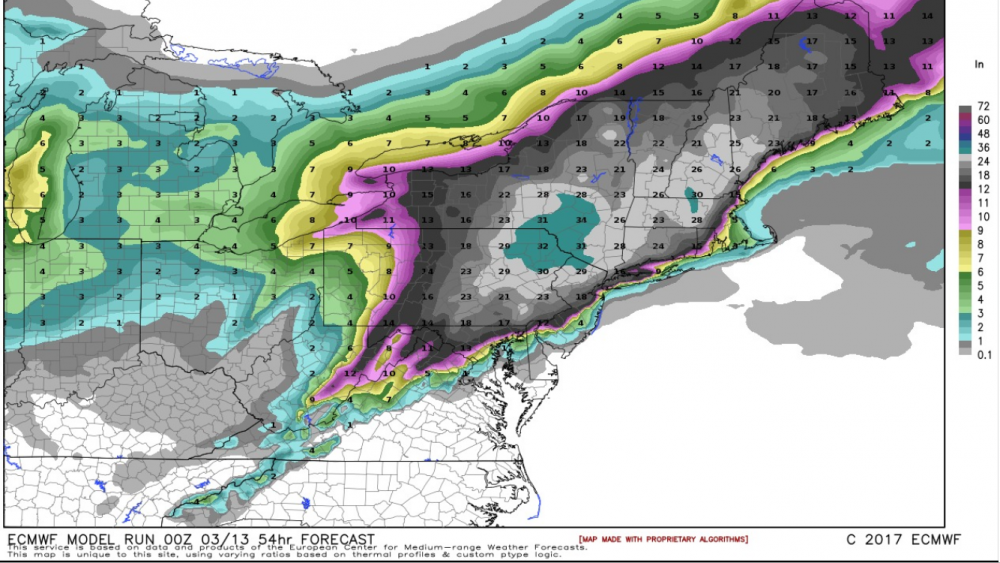
The Euro and to a lesser extent the UK are going to make forecasting this one a real bitch for the NWS and others. Places that changeover to sleet and/or rain for a few hours will see accumulations cut down a lot and we could see gradients from 6" snow/3" sleet/1" rain to 24" of snow over 50 miles, like we did for March 1993. If I recall correctly, we got 11" snow in Edison, 4" sleet and no rain and folks 25 miles W or NW of us, like Chester or Clinton, got 24" of snow and I think folks 25 miles SE of me, like Red Bank got maybe 6" snow, then sleet then a lot of rain. Very tough to forecast that.
Last edited:
wow can you give your carping a break...didnt you just talk about the bickering and everyone else talk about sniping and you start off your post like that
You are some piece of work
I post alot of maps....and gee yes Ive been posting maps showing a lot of snowfall, so proves your point wrong...my pet peeve is about posting maps 5-7 days before an event not one day
Thought it was a legit question, since you hit me hard for posting a map - didn't realize you distinguished between early maps and later ones - and yes, you;ve been balanced in posting maps on this thread. And one of my pet peeves is people posting every map as it comes out, as I think it just confuses folks, since there's so much variability, usually, across a suite of model runs. I'd rather wait an hour or two and present the whole picture, which is what the NWS folks do. I get doing it on the weather boards, since that's what people are there for, but it seems like overkill to me here. Just my opinion. I also defended you by name on American on the GFS questions you posed, which were legitimate questions - asking those same pros why the WPC folks were using the GFS in their model blend if they didn't give the GFS any credence.
Last edited:
Wow, Mt. Holly went with blizzard warnings for Monmouth and Ocean and doesn't mention sleet or rain until one gets to coastal Ocean County, calling for a general 10-16" for Monmouth and a bit more for the I-95 corridor and up to 18-24" for NW NJ - that's 12-18" for Middlesex/Mercer and 18-24" for Somerset/Hunterdon, interestingly. They obviously saw the Euro and don't think it's going to progress any futher west with the track. And Upton converted the blizzard watches to blizzard warnings for NYC, NENJ, and LI (for 12-20" of snow) except for Suffolk, which they have a WSWarning for - presumably some sleet/rain at the height preventing the visibility criterion to be met, I guess. New maps below. Need to get back to sleep, lol...


Last edited:
Thought it was a legit question, since you hit me hard for posting a map - didn't realize you distinguished between early maps and later ones - and yes, you;ve been balanced in posting maps on this thread. And one of my pet peeves is people posting every map as it comes out, as I think it just confuses folks, since there's so much variability, usually, across a suite of model runs. I'd rather wait an hour or two and present the whole picture, which is what the NWS folks do. I get doing it on the weather boards, since that's what people are there for, but it seems like overkill to me here. Just my opinion. I also defended you by name on American on the GFS questions you posed, which were legitimate questions - asking those same pros why the WPC folks were using the GFS in their model blend if they didn't give the GFS any credence.


Are you going to plow my street? Lord knows Hamilton Township isn't going to.Why stop at 24 lets's go 30.
Just stfu alreadywow can you give your carping a break...didnt you just talk about the bickering and everyone else talk about sniping and you start off your post like that
You are some piece of work
I post alot of maps....and gee yes Ive been posting maps showing a lot of snowfall, so proves your point wrong...my pet peeve is about posting maps 5-7 days before an event not one day
Blasting outta here as early as I can this evening to beat as much of the storm before it hits its peak as I head west.
I see these maps and while there are huge hits, but sometimes it looks like the storm track gets more narrow--is that true, or am I just interpreting them incorrectly?
I see these maps and while there are huge hits, but sometimes it looks like the storm track gets more narrow--is that true, or am I just interpreting them incorrectly?
Are you going to plow my street? Lord knows Hamilton Township isn't going to.
Oh, they'll plow it but leave an inch or two to ice over
Ok we all know this one is going to hit. During the lull before, I would be interested in getting everyones view on Winter storm naming. I hate, it does nothing for me and seems to be a way for TWC to try and drum up ratings. Some of their named storms have less impact then an afternoon rain shower in June. NOAA and NWS are against it right? Anyone here like the storm naming thing by a single media source?

Just stfu already
Settle down Francis.... Watching these two bicker is half the fun on these threads.. It only goes downhill when others get involved...
Not on my block. According to their plowing algorithm, I'm on a street with the lowest priority. The last time we got heavy snow in January 2016, we didn't see a plow for 60 hours after the snow stopped. We must live on the same block as the mayor's mother-in-law.Oh, they'll plow it but leave an inch or two to ice over
Similar threads
- Replies
- 477
- Views
- 12K
- Replies
- 608
- Views
- 17K
- Replies
- 62
- Views
- 2K
- Replies
- 104
- Views
- 2K
- Replies
- 771
- Views
- 20K
ADVERTISEMENT
ADVERTISEMENT