Its been a sad year for snow lovers. It might get slightly better on Wednesday but at the moment its looking likely a mainly rain event for most with most of the accumulating snow confined to the usual suspects. Before we get to that, we should see some snow mixing in as the rain ends this afternoon but its really wet so no accumulations expected.
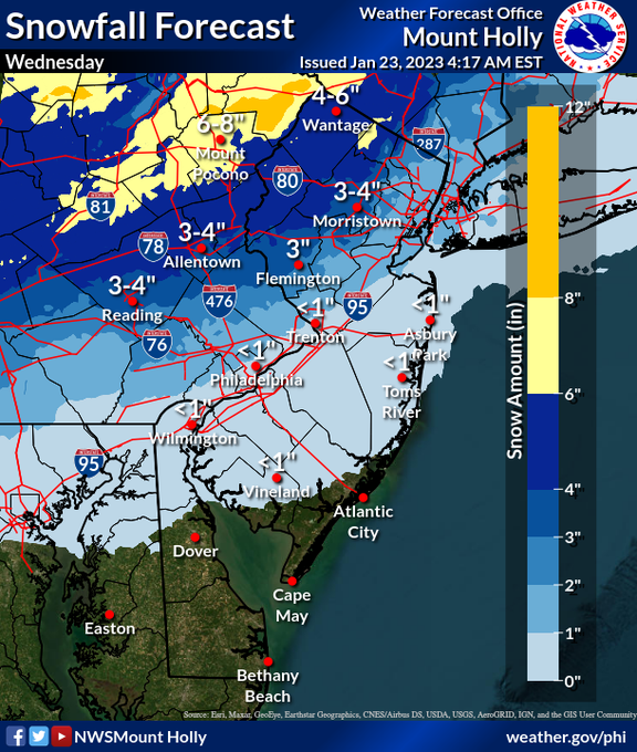
As usual models are all over the place so this forecast still has uncertainty. NAM as usual is revved up and colder and would give us the most potential for snow throughout the area 3-6 throughout central jersey and 8 to the north. Its the biggest outlier right now and not even the 3k NAM backs it up with basically nothing over central jersey and 2-4 to the north. The GFS is 2-4 verbatim for central jersey and up to 8 in the north. Keep in mind the Kuchera map is almost half these amounts 1-2 and maybe 4 to the north. The temps are going to be marginal..perhaps in the mid 30s. If precip is not coming down hard enough, accumulations will be tough. The CMC and RGEM have consistently been warm and almost all a rain event for most after just a touch of snow with no accumulation. Havent seen the Euro but it is more like the GFS from what I heard.
So be aware. We could have just a quick bit of snow that quickly turns to rain or we could have an inch or two or we could have slightly more. All the models do have the changeover to rain. Need to monitor the changing models.
Dan Zarrow

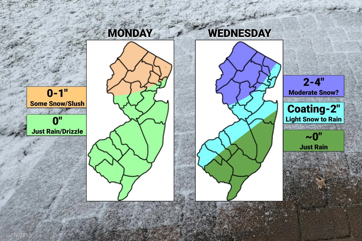
It all begins between mid-morning and midday on Wednesday. Our latest forecast suggests that temperatures will likely be cold enough for a few hours of snow and/or icy mix. Especially away from our coastal counties — along and north of I-195, and along and west of I-295.
Areas to the north and west could even see "a few" inches of accumulation, on the order of 3 or 4. That's enough to cause some tricky travel troubles Wednesday, especially given the middle-of-the-day timing. If this forecast holds, I fully expect to see advisories issued for most of the state once it gets closer.
Warmer air will penetrate our atmosphere Wednesday afternoon, forcing a transition to all rain. Yes, all 21 counties of New Jersey should flip from wintry to just wet by Wednesday evening. Temperatures will eventually push into the 50s Wednesday night, with pockets of heavy rain possible.
Note: We are still 48 hours away from first flakes, which leaves plenty of room for this storm track to "wiggle" and evolve. The impacts here are very much temperature dependent, which makes the forecast even more shaky. We will keep you updated regularly on the latest forecast updates, all the way through Wednesday's sloppiness.
 nj1015.com
As usual models are all over the place so this forecast still has uncertainty. NAM as usual is revved up and colder and would give us the most potential for snow throughout the area 3-6 throughout central jersey and 8 to the north. Its the biggest outlier right now and not even the 3k NAM backs it up with basically nothing over central jersey and 2-4 to the north. The GFS is 2-4 verbatim for central jersey and up to 8 in the north. Keep in mind the Kuchera map is almost half these amounts 1-2 and maybe 4 to the north. The temps are going to be marginal..perhaps in the mid 30s. If precip is not coming down hard enough, accumulations will be tough. The CMC and RGEM have consistently been warm and almost all a rain event for most after just a touch of snow with no accumulation. Havent seen the Euro but it is more like the GFS from what I heard.
So be aware. We could have just a quick bit of snow that quickly turns to rain or we could have an inch or two or we could have slightly more. All the models do have the changeover to rain. Need to monitor the changing models.
Dan Zarrow
Wednesday
Here comes our next storm system. And it looks both complicated and potentially messy. Although I do want to stress it is not currently shaping up to be a "major" winter storm.It all begins between mid-morning and midday on Wednesday. Our latest forecast suggests that temperatures will likely be cold enough for a few hours of snow and/or icy mix. Especially away from our coastal counties — along and north of I-195, and along and west of I-295.
Areas to the north and west could even see "a few" inches of accumulation, on the order of 3 or 4. That's enough to cause some tricky travel troubles Wednesday, especially given the middle-of-the-day timing. If this forecast holds, I fully expect to see advisories issued for most of the state once it gets closer.
Warmer air will penetrate our atmosphere Wednesday afternoon, forcing a transition to all rain. Yes, all 21 counties of New Jersey should flip from wintry to just wet by Wednesday evening. Temperatures will eventually push into the 50s Wednesday night, with pockets of heavy rain possible.
Note: We are still 48 hours away from first flakes, which leaves plenty of room for this storm track to "wiggle" and evolve. The impacts here are very much temperature dependent, which makes the forecast even more shaky. We will keep you updated regularly on the latest forecast updates, all the way through Wednesday's sloppiness.
NJ weather: Rain wraps up, midweek storm looks both wintry and wet
The last in a series of active weather, Wednesday's storm system is New Jersey's best chance of accumulating snow in almost a year.