Currently there is a front scheduled to come through in the Friday/Friday night time period. At this time models have this front coming through dry. This could change so we cannot say with certainly yet if its going to remain dry. So at this point its looking like fair skies with pleasant highs in the low 70s during day similar to the Iowa game. However nighttime temps figure to cool a little bit quicker than that game especially should the front move through. Should settle into the 50s during the game


Colleges
- AAC
- ACC
- Big 12
- Big East
- Big Ten
- Pac-12
- SEC
- Atlantic 10
- Conference USA
- Independents
- Junior College
- Mountain West
- Sun Belt
- MAC
- More
- Navy
- UAB
- Tulsa
- UTSA
- Charlotte
- Florida Atlantic
- Temple
- Rice
- East Carolina
- USF
- SMU
- North Texas
- Tulane
- Memphis
- Miami
- Louisville
- Virginia
- Syracuse
- Wake Forest
- Duke
- Boston College
- Virginia Tech
- Georgia Tech
- Pittsburgh
- North Carolina
- North Carolina State
- Clemson
- Florida State
- Cincinnati
- BYU
- Houston
- Iowa State
- Kansas State
- Kansas
- Texas
- Oklahoma State
- TCU
- Texas Tech
- Baylor
- Oklahoma
- UCF
- West Virginia
- Wisconsin
- Penn State
- Ohio State
- Purdue
- Minnesota
- Iowa
- Nebraska
- Illinois
- Indiana
- Rutgers
- Michigan State
- Maryland
- Michigan
- Northwestern
- Arizona State
- Oregon State
- UCLA
- Colorado
- Stanford
- Oregon
- Arizona
- California
- Washington
- USC
- Utah
- Washington State
- Texas A&M
- Auburn
- Mississippi State
- Kentucky
- South Carolina
- Arkansas
- Florida
- Missouri
- Ole Miss
- Alabama
- LSU
- Georgia
- Vanderbilt
- Tennessee
- Louisiana Tech
- New Mexico State
- Middle Tennessee
- Western Kentucky
- UTEP
- Florida International University
High School
- West
- Midwest
- Northeast
- Southeast
- Other
- Alaska
- Arizona
- California
- Colorado
- Nevada
- New Mexico
- Northern California
- Oregon
- Southern California Preps
- Washington
- Edgy Tim
- Indiana
- Kansas
- Nebraska
- Iowa
- Michigan
- Minnesota
- Missouri
- Oklahoma Varsity
- Texas Basketball
- Texas
- Wisconsin
- Delaware
- Maryland
- New Jersey Basketball
- New Jersey
- New York City Basketball
- Ohio
- Pennsylvania
- Greater Cincinnati
- Virginia
- West Virginia Preps
ADVERTISEMENT
Install the app
How to install the app on iOS
Follow along with the video below to see how to install our site as a web app on your home screen.
Note: This feature may not be available in some browsers.
You are using an out of date browser. It may not display this or other websites correctly.
You should upgrade or use an alternative browser.
You should upgrade or use an alternative browser.
Weather for Nebraska
- Thread starter bac2therac
- Start date
Sounds about right. I will say that every major global model, right now, shows no rain for our area through early Saturday, but a couple show some light rain after that and/or not far from our area during the evening, so hard to completely rule out the possibility of a light shower or two associated with the front; see the NWS discussion below. Having said that, given that this looks to be a fairly weak cold front coming through on Friday, it's extremely unlikely that we'd see more than 0.05" of rain, which is certainly not a washout and many would call that nuisance rain. I'd say it's just about a lock, though, for seasonably warm (avg high/low on 10/7 is 70/48F), dry tailgates with highs around 70F; temps will likely drop through the 60s through the game and into the upper 50s by the end of the game. Difficult to predict winds this far out, but with a weak front, winds are unlikely to be a factor.
https://forecast.weather.gov/produc...&format=CI&version=1&glossary=1&highlight=off
LONG TERM /WEDNESDAY THROUGH SATURDAY/...
Cooler readings will again arrive for the
weekend when highs will mostly be in the 60s with some highs in the
50s for the NW areas. Lows Thu/Fri will mostly be in the 50s with 40s
NW. Next weekend some lows in the 30s are possible for the NW areas.
Precipitation will be scarce for the late week and next weekend
periods. Low pressure will develop across the Great Lakes and then
move into new England Fri/Fri night. An associated cold front will
cross the area late Fri. The models are not making much precip with
the feature attm. It`s possible that this could change however.
We`ll continue withe the dry fcst for now.
Last edited:
No change
Front still proggred to sweep through sometime Friday. Looks to come through dry but not definitive. Temperatures though going to fall.
Nice low 70s for early tailgates down i to the 60s by 6PM and likely 50s by halftime
Similar to Iowa game but some ticks cooler during the game
Front still proggred to sweep through sometime Friday. Looks to come through dry but not definitive. Temperatures though going to fall.
Nice low 70s for early tailgates down i to the 60s by 6PM and likely 50s by halftime
Similar to Iowa game but some ticks cooler during the game
It’s a wash out for the next 3 days.. 2 inches of rain coming tonight.
Thankfully Thursday is a dry day and Friday looks beautiful.
Hopefully we get 40,000 in the Stadium
Thankfully Thursday is a dry day and Friday looks beautiful.
Hopefully we get 40,000 in the Stadium

As I just said in the other thread, the forecast for today was off a bit, as we weren't supposed to get much rain this afternoon along and NW of 95 and everyone, even NW of 95, has gotten up to 1/4" with many getting over 1/2" near the coast. And they did up the rainfall forecast for tomorrow into Weds for up to 1" along 95 (graphic below is for Pway), but even then, that would make about 3-3.5" or so since Saturday (for Pway) and that really should be all gone by Friday afternoon, given dry conditions before this event and 2 days of drying out (rain should be over by Weds am).It’s a wash out for the next 3 days.. 2 inches of rain coming tonight.
Thankfully Thursday is a dry day and Friday looks beautiful.
Hopefully we get 40,000 in the Stadium
Friday still looks great, but the NWS is still a bit worried about a little bit of light rain with the weak front Friday afternoon/evening, although they have said any rain would be very light (<0.05" on any model showing rain - most don't) - and it's much more likely to be completely dry than to have even light showers. Still looks mostly sunny and warm with highs in the low 70s and temps dropping into the mid-50s by the end of the game (that's exactly what we had for Iowa - was 56F when I left the yellow lot).
it will be cooler during the game than it was for Iowa....for one the sun is setting earlier and secondly its going to be breezy and third we have a front coming through. Do not be fooled by some nice conditions late in the afternoon for tailgating. Make sure you bring what you need to stay comfortable
Forecast high is 74F for 10/7 vs. the high of 72F on 9/24 and the temp is forecast to be about 55F at the end of the game (10:30 pm) vs. the 56F I noted at the end of the game in the yellow lot after Iowa. The sunset is about 20 minutes earlier than it was on 9/24, which is a non-issue, and currently the forecast is for <10 mph winds on 10/7, which is comparable to the winds on 9/24. So it will not be cooler than it was for Iowa, unless something in the forecast changes. I was in a t-shirt and shorts for Iowa and was quite comfortable and intend to be dressed similarly for Nebraska. I'm sure you'll be in your parka.it will be cooler during the game than it was for Iowa....for one the sun is setting earlier and secondly its going to be breezy and third we have a front coming through. Do not be fooled by some nice conditions late in the afternoon for tailgating. Make sure you bring what you need to stay comfortable
And with regard to the threat for a light shower or two, no models are showing any showers for CNJ during the game or tailgates. The closest light showers are in NWNJ/Poconos in the evening and even these are scattered and would only put down about 0.01-0.02" of rain, which is definitely nuisance level.
LONG TERM /FRIDAY THROUGH MONDAY/...
The dry pattern that begins during the short term continues into the
weekend. An upper trough across the Northeast states and Middle
Atlantic flattens and is replaced with more zonal from by late
weekend. A short wave will move through early next week. The only
surface feature of significance will be a cold front which will move
across the area Fri night.
The forecast is dry through the period. High pressure will prevail
with only a cold front moving though late Friday. I have kept the
slight chance of showers (from the earlier forecast) in for the
southern Poconos and northern NJ for Fri night. Temperatures will be
a little above normal Friday but after that, a turn towards chilly
autumn temperatures is expected.
PRETTY SIMPLE EVERYONE:
DRESS THE SAME WAY YOU DID FOR THE IOWA GAME (but in BLACK).
DRESS THE SAME WAY YOU DID FOR THE IOWA GAME (but in BLACK).
That's pretty much it. I erred on the side of caution wearing jeans not shorts for the Iowa tailgate and game and brought a hoodie into the game. Same for Friday, just with a black red block R hoodie.PRETTY SIMPLE EVERYONE:
DRESS THE SAME WAY YOU DID FOR THE IOWA GAME (but in BLACK).
And be sure to wear black under-garments. Lacey black under-garments for you ladies.PRETTY SIMPLE EVERYONE:
DRESS THE SAME WAY YOU DID FOR THE IOWA GAME (but in BLACK).
This will be checked at the gates.
I had cargo shorts on and was fine (put a long-sleeved red UA shirt on underneath my R-Football T) as well.That's pretty much it. I erred on the side of caution wearing jeans not shorts for the Iowa tailgate and game and brought a hoodie into the game. Same for Friday, just with a black red block R hoodie.
You dirty bird. Now I know who to blame for the delays entering the stadium! 😄And be sure to wear black under-garments. Lacey black under-garments for you ladies.
This will be checked at the gates.
I just take my blackouts very seriously, is all. 🙂You dirty bird. Now I know who to blame for the delays entering the stadium! 😄
Forecast high is 74F for 10/7 vs. the high of 72F on 9/24 and the temp is forecast to be about 55F at the end of the game (10:30 pm) vs. the 56F I noted at the end of the game in the yellow lot after Iowa. The sunset is about 20 minutes earlier than it was on 9/24, which is a non-issue, and currently the forecast is for <10 mph winds on 10/7, which is comparable to the winds on 9/24. So it will not be cooler than it was for Iowa, unless something in the forecast changes. I was in a t-shirt and shorts for Iowa and was quite comfortable and intend to be dressed similarly for Nebraska. I'm sure you'll be in your parka.
And with regard to the threat for a light shower or two, no models are showing any showers for CNJ during the game or tailgates. The closest light showers are in NWNJ/Poconos in the evening and even these are scattered and would only put down about 0.01-0.02" of rain, which is definitely nuisance level.
LONG TERM /FRIDAY THROUGH MONDAY/...
The dry pattern that begins during the short term continues into the
weekend. An upper trough across the Northeast states and Middle
Atlantic flattens and is replaced with more zonal from by late
weekend. A short wave will move through early next week. The only
surface feature of significance will be a cold front which will move
across the area Fri night.
The forecast is dry through the period. High pressure will prevail
with only a cold front moving though late Friday. I have kept the
slight chance of showers (from the earlier forecast) in for the
southern Poconos and northern NJ for Fri night. Temperatures will be
a little above normal Friday but after that, a turn towards chilly
autumn temperatures is expected.
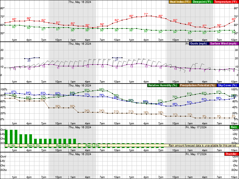
you can say what you want but its going to be a bit cooler. It wasnt all that bad, still needed long pants and sweatshirt or in my case a t shirt over a thermal but it defintiely wasnt shorts and shorts sleeves weather then and it will not be Friday night during the game, we have a pretty big cold front coming through, not precip wise but air mass wise and highs will not get out of the upper 50s on Saturday. That breeze that comes off the Raritan can be pretty chilly when it happens. As we get deeper into fall it cools off a little more rapidly after sunset, you can post the nifty charts for 3 days away which is pretty meaningless since it was meaningless for what happened in colossal bust the past 3 days
I think most will find a recommendation to wear long pants with a sweatshirt and/or jacket to be reasonable. I will take the high road here.
I'm not saying anything I "want" - I'm saying what the models and forecasts currently say and they say the temperature profile will be nearly identical to what we saw for Iowa. Sure that could change, but those are the facts and yes, it's going to get quite chilly this weekend, but that's irrelevant as it's after the game. You're the one posting based on feelings and speculation about winds and the Raritan (winds are forecast to be <10 mph and will be out of the NW, so the Raritan will have no impact, plus it's warmer (~65F than it'll be in the 2nd half). I also have no idea what you mean about taking the high road - are you implying my gentlest of teasing about wearing a parka is taking the low road? C'mon.you can say what you want but its going to be a bit cooler. It wasnt all that bad, still needed long pants and sweatshirt or in my case a t shirt over a thermal but it defintiely wasnt shorts and shorts sleeves weather then and it will not be Friday night during the game, we have a pretty big cold front coming through, not precip wise but air mass wise and highs will not get out of the upper 50s on Saturday. That breeze that comes off the Raritan can be pretty chilly when it happens. As we get deeper into fall it cools off a little more rapidly after sunset, you can post the nifty charts for 3 days away which is pretty meaningless since it was meaningless for what happened in colossal bust the past 3 days
I think most will find a recommendation to wear long pants with a sweatshirt and/or jacket to be reasonable. I will take the high road here.
Also, the forecast for the past couple of days was not a "colossal bust" - we had a forecast of 1-2" along 95 and 2-4 toward the coast and we've seen almost twice that. The storm overperformed, but it was forecast decently - it's not like no rain was forecast at all.
I had zero problem wearing shorts for the Iowa game (and I'm not in my 30's anymore, lol....). May do the same for this week but I'm sure I'd be fine wearing jeans as well.you can say what you want but its going to be a bit cooler. It wasnt all that bad, still needed long pants and sweatshirt or in my case a t shirt over a thermal but it defintiely wasnt shorts and shorts sleeves weather then and it will not be Friday night during the game, we have a pretty big cold front coming through, not precip wise but air mass wise and highs will not get out of the upper 50s on Saturday. That breeze that comes off the Raritan can be pretty chilly when it happens. As we get deeper into fall it cools off a little more rapidly after sunset, you can post the nifty charts for 3 days away which is pretty meaningless since it was meaningless for what happened in colossal bust the past 3 days
I think most will find a recommendation to wear long pants with a sweatshirt and/or jacket to be reasonable. I will take the high road here.
You've already mentioned in the past...I'm not saying anything I "want" - I'm saying what the models and forecasts currently say and they say the temperature profile will be nearly identical to what we saw for Iowa. Sure, that could change, but those are the facts and yes, it's going to get quite chilly this weekend, but that's irrelevant as it's after the game. * You're the one posting based on feelings and speculation about winds and the Raritan (winds are forecast to be <10 mph and will be out of the NW, so the Raritan will have no impact, plus it's warmer (~65F than it'll be in the 2nd half). I also have no idea what you mean about taking the high road - are you implying my gentlest of teasing about wearing a parka is taking the low road? C'mon.
Also, the forecast for the past couple of days was not a "colossal bust" - we had a forecast of 1-2" along 95 and 2-4 toward the coast and we've seen almost twice that. The storm overperformed, but it was forecast decently - it's not like no rain was forecast at all.
your personal thermostat is different compared to others so what you * feel might be different than others. Simple as that.I was in a t-shirt and shorts for Iowa and was quite comfortable and intend to be dressed similarly for Nebraska. I'm sure you'll be in your parka.
That is absolutely true, but you're not reading the posts closely. He actually said it's going to be cooler for NE than it was for Iowa and as of this moment, every piece of meteorological forecast data says the temps will be nearly identical (and winds). Hence my comment that he's basing his prediction of it being cooler on feelings or intuition or something other than the data.You already mentioned in the past your personal thermostat is different compared to others so what you feel might be different than others. Simple as that.
We'll see who ends up being correct in this golden gloves level battle of the amateur mets...That is absolutely true, but you're not reading the posts closely. He actually said it's going to be cooler for NE than it was for Iowa and as of this moment, every piece of meteorological forecast data says the temps will be nearly identical (and winds). Hence my comment that he's basing his prediction of it being cooler on feelings or intuition or something other than the data.
Maybe so. But it's still way more fun talking about your screwy personal thermometer.That is absolutely true, but you're not reading the posts closely. He actually said it's going to be cooler for NE than it was for Iowa and as of this moment, every piece of meteorological forecast data says the temps will be nearly identical (and winds). Hence my comment that he's basing his prediction of it being cooler on feelings or intuition or something other than the data.
IIRC, didn't you wear shorts and a t-shirt to the infamous West Virginia snow bowl game? The one where the field ops folks plowed away the snow on the sidelines and then the couch-burners kept running out wide and getting TDs to win the game?
Normal people get cold 20 degrees before you do. It's a fact! 😃
Now here's an actual update that could lead to it feeling cooler: all of a sudden, the 12Z models are now showing wind gusts in the afternoon in the 20-25 mph range with sustained winds in the 10-15 mph range, with winds dropping off around kickoff to a calmer 8-10 mph winds with minimal gusts. Winds like that when it's 70F and sunny will not be much of a factor, but if they persist into the game, that will certainly make folks feel colder. I've often said winds are the hardest thing to predict well in advance...
I'm just sayin... 🤷♂️Now here's an actual update that could lead to it feeling cooler: all of a sudden, the 12Z models are now showing wind gusts in the afternoon in the 20-25 mph range with sustained winds in the 10-15 mph range, with winds dropping off around kickoff to a calmer 8-10 mph winds with minimal gusts. Winds like that when it's 70F and sunny will not be much of a factor, but if they persist into the game, that will certainly make folks feel colder. I've often said winds are the hardest thing to predict well in advance...
I could lie to perpetuate the myth, but no, I wore jeans and a windbreaker, as it was chilly.Maybe so. But it's still way more fun talking about your screwy personal thermometer.
IIRC, didn't you wear shorts and a t-shirt to the infamous West Virginia snow bowl game? The one where the field ops folks plowed away the snow on the sidelines and then the couch-burners kept running out wide and getting TDs to win the game?
Normal people get cold 20 degrees before you do. It's a fact! 😃
lol, no change in temperature though, which is what the argument is about...I'm just sayin... 🤷♂️
Hm... okay, I'm definitely not betting on my memory over yours. But I'm positive your wore sneakers and were standing in a couple inches of sleet that whole game. I had on two pairs of ski socks and boots and my feet froze.I could lie to perpetuate the myth, but no, I wore jeans and a windbreaker, as it was chilly.
And there was another game where J came with me and was complaining about his feet and hands hurting from the cold (and where he stopped complaining about it at the end of the 3rd Q because, he said, he couldn't feel his hands or feet at all anymore - oops). Anyway, pretty sure you were under-dressed for that game too.
You're the original Mr. Ice Miser. Don't even try to deny it.
But with the wind it might feel cooler for MOST, yes?lol, no change in temperature though, which is what the argument is about...
Don't really care what the bulb says, it's what the body says is the "real feel" for many.
That's what she said.Don't really care what the bulb says, it's what the body says is the "real feel" for many.
And be sure to wear black under-garments. Lacey black under-garments for you ladies.
So does this work for you?
Undergarment-wise, yes. Just need to dye her all black for the game. And the shoes need to be black.So does this work for you?
That is absolutely true, but you're not reading the posts closely. He actually said it's going to be cooler for NE than it was for Iowa and as of this moment, every piece of meteorological forecast data says the temps will be nearly identical (and winds). Hence my comment that he's basing his prediction of it being cooler on feelings or intuition or something other than the data.
Its going to be somewhat cooler because we have a serious cold front moving in which we didnt have last time where the trending temp was warmer for the following day
I assume you’re laughing at the “30’s” part of that comment lolI had zero problem wearing shorts for the Iowa game (and I'm not in my 30's anymore, lol....). May do the same for this week but I'm sure I'd be fine wearing jeans as well.
Now here's an actual update that could lead to it feeling cooler: all of a sudden, the 12Z models are now showing wind gusts in the afternoon in the 20-25 mph range with sustained winds in the 10-15 mph range, with winds dropping off around kickoff to a calmer 8-10 mph winds with minimal gusts. Winds like that when it's 70F and sunny will not be much of a factor, but if they persist into the game, that will certainly make folks feel colder. I've often said winds are the hardest thing to predict well in advance...
Lol see..and they mentioned winds in their previous disco which you ignored
I assume you’re laughing at the “30’s” part of that comment lol
It was too chilly for shorts during game
I had shorts for tailgating but changed to long pants
I mean to each his own! I usually wear shorts in the 50’s as long as I can - and as soon as I can - but it’s not for everyone.It was too chilly for shorts during game
I had shorts for tailgating but changed to long pants
Listen…I’ve been miserable the last 2 days…this sucks lol but by Friday it’ll feel like summer again to me!
The NWS hasn't mentioned winds for Friday in any discussion I've seen - and if they had mentioned them this morning, then this morning's hourly weather graphic (which I posted this morning) should've had increased winds, but it didn't. They only increased the winds this afternoon after seeing the 12Z models showing some gusts, which were not in previous model runs. Which is fine, as things change, and I even mentioned winds in my first post in the thread, as they're very hard to predict. But you had no model or NWS discussion basis to be talking up winds this morning. And temps still look to be about identical to those for Iowa, so the forecast is not any cooler, temperature-wise.Lol see..and they mentioned winds in their previous disco which you ignored
It'll be fine during the day but by the 2nd half...........I mean to each his own! I usually wear shorts in the 50’s as long as I can - and as soon as I can - but it’s not for everyone.
Listen…I’ve been miserable the last 2 days…this sucks lol but by Friday it’ll feel like summer again to me!
Then again if you have enough anti-freeze in your system😁
You do realize you're having a conversation with yourself, don't you? Not that there's anything wrong with that...I assume you’re laughing at the “30’s” part of that comment lol
Of course, but we're having a meteorological argument about air temperature, not wind chill...But with the wind it might feel cooler for MOST, yes?
Don't really care what the bulb says, it's what the body says is the "real feel" for many.
So it might be colder than Iowa?Of course, but we're having a meteorological argument about air temperature, not wind chill...
What might be colder than Iowa? And he's on second base.So it might be colder than Iowa?
Similar threads
- Replies
- 13
- Views
- 365
- Replies
- 74
- Views
- 3K
- Replies
- 1
- Views
- 104
- Replies
- 29
- Views
- 789
ADVERTISEMENT
Latest posts
-
 ***WAR ROOM: Latest Recruit Scoop and Team News on Rutgers Athletics***
- Latest: RU-Choppin-Ohio
-
Football Things Rutgers submitted to EA Sports for the NCAA Video Game?
- Latest: Scarlet Shack
-
-
-

ADVERTISEMENT