ADVERTISEMENT

OT: Hurricane Lee now a Cat 1 hurricane - likely landfall as near Cat 1 in Canada (or maybe far eastern Maine) on 9/16-17

RU848789

Legend
Gold Member
Jul 27, 2001
60,562
39,147
113
Metuchen, NJ
In honor of @e5fdny, starting this one early, since the post below has been in the tropical thread for hours, with zero comments and I'm pretty sure people will be interested in this one once it has its own thread. Anyway, as of 11 am this morning, Invest 95L became a tropical depression and will very likely soon become Tropical Storm Lee (it probably already is) - and it won't be long before future Lee becomes a hurricane and likely a major hurricane within 3-4 days. One doesn't often see a NHC forecast going from TD to major hurricane in 3 days and in fact, supposedly this is the first time an initial advisory had a storm becoming a Cat 4 hurricane, according to Tomer Burg (met). This is a testament to the abnormally warm ocean temps and the low shear, moist environment in the storm's path.


https://www.nhc.noaa.gov/graphics_at3.shtml?start#contents

Best guess right now is that future Lee will head just north of the northern Leeward Islands and the Greater Antilles (PR/Hispaniola/Cuba) by Days 5-7 and then likely turn a bit towards the north, probably well east of the Bahamas and perhaps west of Bermuda and east of the US coast (like Franklin), but after that we're into Days 8-9 and beyond, where model divergence is too great for much confidence in the track.

Because of this high uncertainty, there is some chance (10-20%?) that the storm could strike the Canadian Maritimes and possibly even SE New England (which means eastern LI would be in play, too) and then Atlantic Canada. Obviously, if New England is possible, the rest of the east coast, including our area, has a small chance of also being possible, given how far out the storm is. Please don't pay attention to operational model forecast runs beyond Day 6-7 and especially at Day 10+ (today's 12Z GFS shows Lee grazing Cape Cod and Downeast Maine as a Cat 2 in 11-12 days), since they're generally garbage that far out and ensemble forecasts are better for looking at tracks. I'm sure social media will start buzzing with that GFS run shortly if not already.

Keep in mind that Irma in 2017, when it was at a similar longitude as future Lee is was expected to stay off the US east coast by most models/ensembles and most will remember that the storm actually hit northern Cuba, then rode up the western side of Florida - different setup than this storm, but the point is that 8+ day forecasts can be pretty far off.

Really good post on AmericanWx discussing some of the possibilities...

https://www.americanwx.com/bb/topic...ry-forthcoming/?do=findComment&comment=6994107

FORECAST POSITIONS AND MAX WINDS

INIT 05/1500Z 12.5N 40.2W 30 KT 35 MPH
12H 06/0000Z 12.8N 42.1W 40 KT 45 MPH
24H 06/1200Z 13.6N 44.7W 50 KT 60 MPH
36H 07/0000Z 14.4N 47.2W 60 KT 70 MPH
48H 07/1200Z 15.3N 49.7W 70 KT 80 MPH
60H 08/0000Z 16.2N 52.2W 80 KT 90 MPH
72H 08/1200Z 17.3N 54.7W 95 KT 110 MPH
96H 09/1200Z 19.4N 59.1W 115 KT 130 MPH
120H 10/1200Z 21.5N 63.5W 120 KT 140 MPH
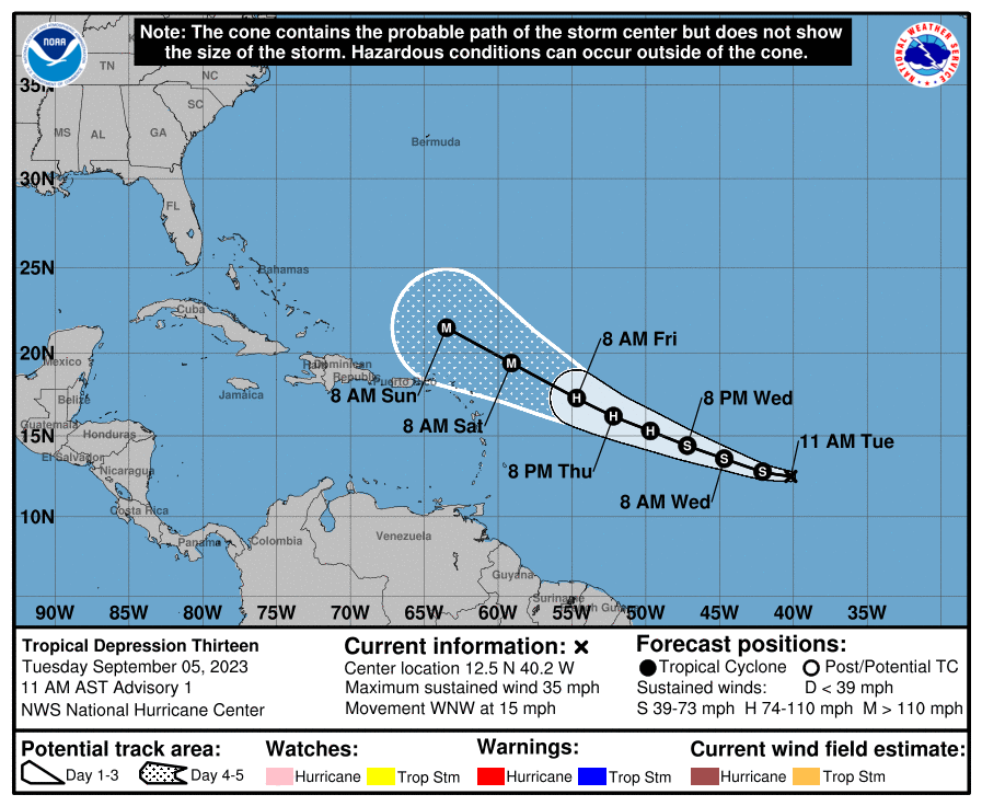
U8Vsh9A.png
 
Last edited:
When would storm be parallel with NJ presuming it travels northward in the Atlantic ? Mid next week? Thanks as always !
 
When would storm be parallel with NJ presuming it travels northward in the Atlantic ? Mid next week? Thanks as always !
Yep, would likely start getting big swells in NJ by next Tues/Weds and through next weekend, assuming the storm stays several hundred miles off the east coast.
 
  • Like
Reactions: BigEastPhil
We officially have TS Lee, forecast to be a major hurricane by Friday and a Cat 4 by Saturday; still looking like it will just graze PR/Hispaniola with some rain and gusty winds, but perhaps below TS force, especially with the islands on the weaker, south side of the storm. Beyond that is the big question - no difference in thinking from my post earlier today.

https://www.nhc.noaa.gov/

FORECAST POSITIONS AND MAX WINDS

INIT 05/2100Z 13.2N 41.8W 40 KT 45 MPH
12H 06/0600Z 13.7N 43.7W 50 KT 60 MPH
24H 06/1800Z 14.4N 46.2W 60 KT 70 MPH
36H 07/0600Z 15.2N 48.5W 70 KT 80 MPH
48H 07/1800Z 16.2N 51.0W 80 KT 90 MPH
60H 08/0600Z 17.2N 53.6W 90 KT 105 MPH
72H 08/1800Z 18.3N 56.0W 110 KT 125 MPH
96H 09/1800Z 20.4N 60.5W 120 KT 140 MPH
120H 10/1800Z 22.2N 64.3W 125 KT 145 MPH
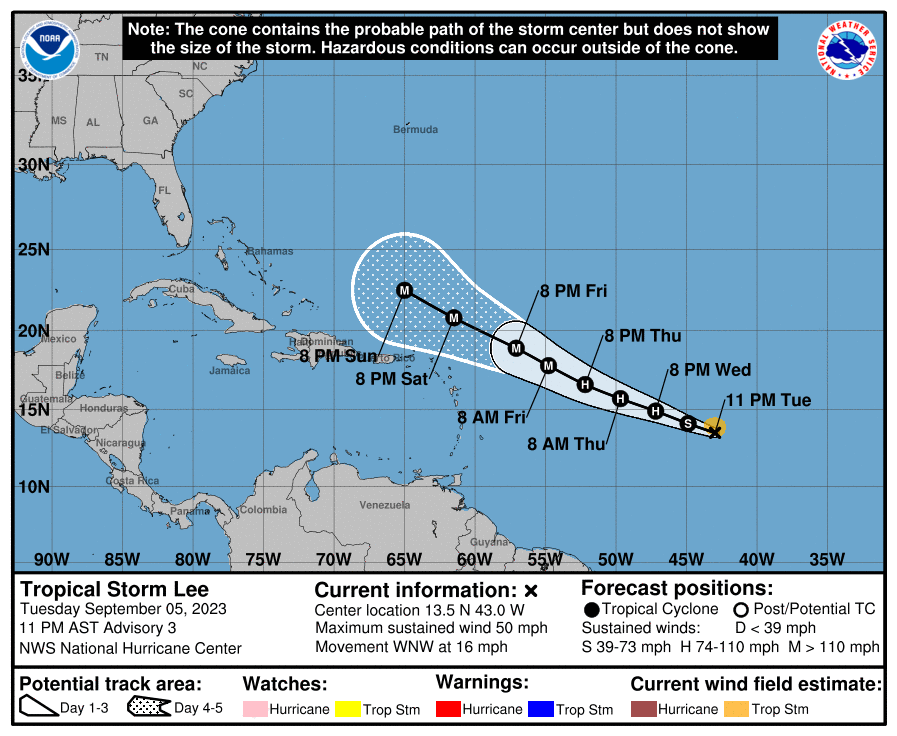
Lee is up to 50 mph and getting better organized and still forecast to undergo fairly rapid intensification over the next 3-4 days, reaching major hurricane status in about 48-60 hours (>110 mph) and reaching Cat 4 (140 mph or more) status by Saturday, as it likely passes well north of the northern Leeward Islands and Puerto Rico (by ~150 miles or so, although those islands are still on the edge of the forecast cone). And soon after that, the storm is forecast to reach 150 mph, which means Cat 5 is certainly on the table (157 mph or more).

Still too early to know if Lee will have any direct impact on the east coast (beyond heavy surf, which is a given almost), with the most likely track being well off the coast - with Atlantic Canada having a bit more chance of taking a hit in 10+ days. But uncertainty on the long term steering currents over the CONUS and Atlantic Ocean is way too high to completely rule out a US landfall (especially New England), especially since there are a few ensemble members showing a US hit (but the vast majority do not).

FORECAST POSITIONS AND MAX WINDS

INIT 06/0300Z 13.5N 43.0W 45 KT 50 MPH
12H 06/1200Z 14.1N 44.9W 55 KT 65 MPH
24H 07/0000Z 14.9N 47.2W 65 KT 75 MPH
36H 07/1200Z 15.7N 49.7W 75 KT 85 MPH
48H 08/0000Z 16.6N 52.2W 90 KT 105 MPH
60H 08/1200Z 17.8N 54.8W 105 KT 120 MPH
72H 09/0000Z 18.9N 57.1W 115 KT 130 MPH
96H 10/0000Z 20.8N 61.5W 125 KT 145 MPH
120H 11/0000Z 22.5N 65.0W 130 KT 150 MPH

ORLQadr.png
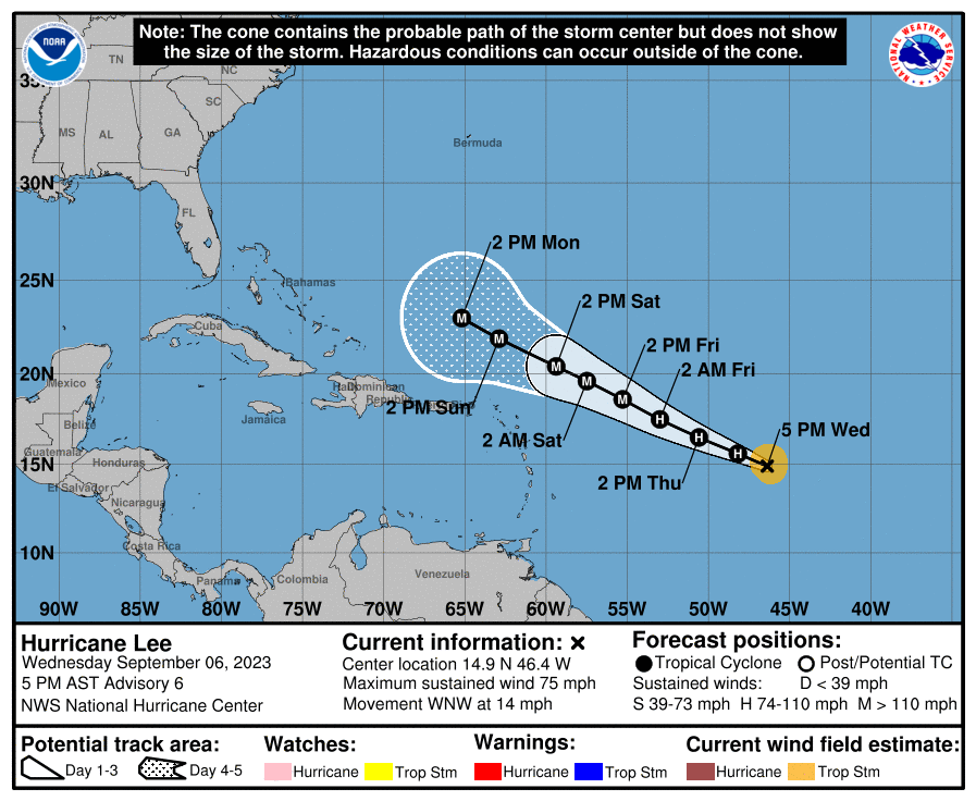
Other than Lee becoming a 75 mph hurricane as of 5 pm, not much change in the forecast, as Lee should be a major hurricane by Friday and a Cat 4 hurricane (150 mph winds, not too far from Cat 5) by Saturday. As hoped, the track hasn't changed much, which means the northern Leeward Islands and Puerto Rico are now well out of the track cone, which is good news for them, so they should only experience some showers and sub-tropical storm winds and heavy surf.

Beyond the 5-day NHC forecast, which puts Lee at about 65W/23N, i.e., at Bermuda's longitude and just south of Key West's latitude, the track uncertainty really starts to increase. All of the global and hurricane models show Lee bending toward the north around Day 6/7 at the latitude of Miami and longitude of Cape Cod, and then heading north for a few days and then probably NNE towards the Canadian Maritimes by next weekend (possibly coming close to Bermuda early next week).

Whether or not Lee comes much closer to the US east coast is still not clear, although none of the models show that with their operational runs and very few of the ensemble member runs strike the US, which is a strong indication that Lee will stay offshore, but there's enough uncertainty in a 9-10 day forecast such that a US close call or even hit (with LI/New England being the most likely location for any such thing; areas south of NC are just about out of the woods, while our area is even less likely than New England) cannot be totally ruled out. A potential landfall in eastern Canada, especially Newfoundland, is a greater probability (by then the storm would likely be transitioning to an extratropical system and maybe be a Cat 1).

This is especially true given the question of how strong will the Western Atlantic Ridge (WAR) remain and will it expand westward, which could drive Lee closer to the US, as well as how strong will the major trough be coming across the US and driving offshore mid/late next week, helping sweep Lee NE and away from the US. Those steering currents are difficult to predict at 7-10 days, so this one still bears watching. Biggest risk to the US right now is likely very heavy surf/erosion/rip-currents.

Nice tweet/discussion by Jeff Berardelli (met who used to work at Channel 4 in NYC)...


https://www.nhc.noaa.gov/graphics_at3.shtml?start#contents

FORECAST POSITIONS AND MAX WINDS

INIT 06/2100Z 14.9N 46.4W 65 KT 75 MPH
12H 07/0600Z 15.6N 48.2W 75 KT 85 MPH
24H 07/1800Z 16.5N 50.6W 85 KT 100 MPH
36H 08/0600Z 17.5N 53.0W 95 KT 110 MPH
48H 08/1800Z 18.6N 55.3W 110 KT 125 MPH
60H 09/0600Z 19.6N 57.5W 120 KT 140 MPH
72H 09/1800Z 20.4N 59.4W 130 KT 150 MPH
96H 10/1800Z 21.9N 62.9W 130 KT 150 MPH
120H 11/1800Z 23.0N 65.2W 125 KT 145 MPH


ZIhgaX9.png
 
That's what you said for Sandy, too, playing it down until the very end as non-issue. If we had real moderation you'd never be allowed to post in a weather thread.
That's what everyone said about Sandy this far out. You can't take credit for crying wolf every time and being right once via dumb luck. At the end of the day, we were fully prepared and the first town in our area to recover.
 
That's what everyone said about Sandy this far out. You can't take credit for crying wolf every time and being right once via dumb luck. At the end of the day, we were fully prepared and the first town in our area to recover.
You were saying that about Sandy when it was 2-3 days away and clearly heading for NJ. You were thread-banned when I asked that you be removed, as I was concerned your downplaying a potentially life-threatening event (like you still do with most hurricanes, including Idalia) would persuade people not to evacuate from the Shore.
 
You were saying that about Sandy when it was 2-3 days away and clearly heading for NJ. You were thread-banned when I asked that you be removed, as I was concerned your downplaying a potentially life-threatening event (like you still do with most hurricanes, including Idalia) would persuade people not to evacuate from the Shore.
I wasn't posting then, too busy with real prep instead of being an irrelevant keyboard warrior. LOL! It's still comical to see that you actual think your posts mean anything.
 
You were saying that about Sandy when it was 2-3 days away and clearly heading for NJ. You were thread-banned when I asked that you be removed, as I was concerned your downplaying a potentially life-threatening event (like you still do with most hurricanes, including Idalia) would persuade people not to evacuate from the Shore.
Stop indulging the foolish twat. You are feeding a troll. Any updates ?
 
From weather.com this morning (certainly not a “fish storm):


For now the trends in the ensemble computer model guidance over the last few days suggests the "recurve" may not be sharp enough to avoid all land areas.
Lee will eventually make a right-hand turn to the north next week. But its steering winds may not allow it to curl northeast sharp enough to avoid either a direct hit or a graze of at least parts of Atlantic Canada late next week.
 
The one thing we know for sure with this storm is that east coast surfers are going to love it next week...
sport ocean GIF by Olympic Channel


I went in the last time, even though I shouldn't have, and will do so again this time.

Mahalo...🤙
 
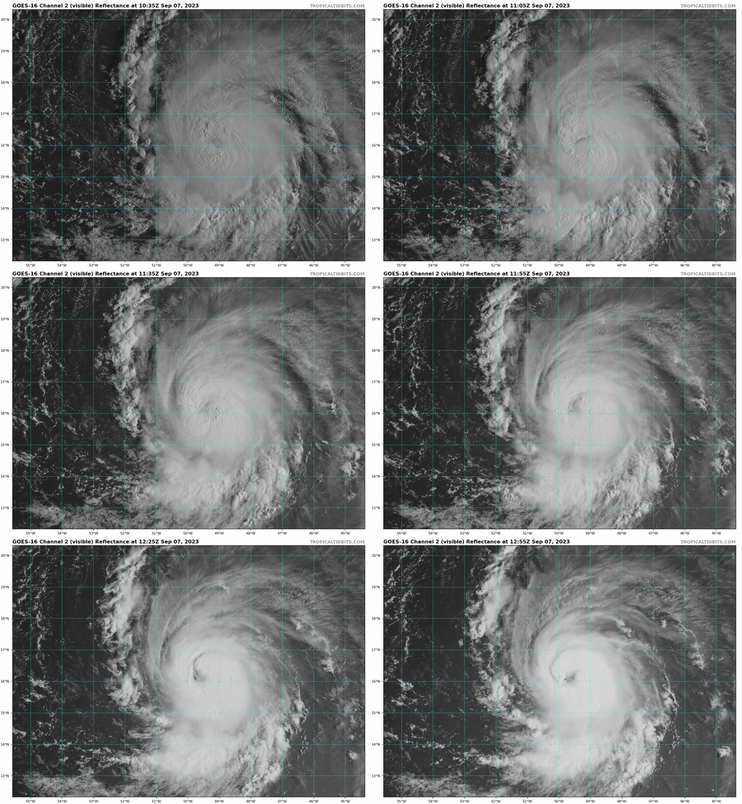
Lee exploding as we speak (could already be a Cat 2) and is forecast to be 155 mph in 2 days. Still looks to remain offshore, but a hit on New England or Canada can't be ruled out and we won't have high confidence in where Lee goes after Day 5-6 for at least a few more days. Lee will, however, likely weaken some as it heads towards or a bit west of Bermuda, due to the locally colder ocean temps there, left in the wakes of Franklin and Idalia (due to upwelling from those storms).

00afd9cc339705ebee586192868b68f5.gif
 
Last night's Euro crushes Nova Scotia as a probable Cat 3 hurricane next Saturday. The GFS/CMC/UK are all further offshore/east, so the Euro is an outlier, plus it's still 9-10 days away, which is an eternity in modeling, with very high uncertainty. The point is if eastern Canada is in play, then LI/New England is still in play, even if a very low probability (and our area is still a very very low probability).
 
  • Wow
Reactions: RUDiddy777
That's what everyone said about Sandy this far out. You can't take credit for crying wolf every time and being right once via dumb luck. At the end of the day, we were fully prepared and the first town in our area to recover.
Not true at all my guy. Models were in remarkable agreement on a hard left turn and east coast strike 9 days prior to Sandy’s landfall and held steady. In fact, it was one of the best long range model verifications for an event of that size ever, up there with the forecasting of the 1993 superstorm.

That said, Lee doesn’t pose a threat to the US other than a glancing blow, there isn’t any blocking and certainly nothing like the Omega block that cause Sandy to turn.
 
  • Like
Reactions: RUDiddy777
Not true at all my guy. Models were in remarkable agreement on a hard left turn and east coast strike 9 days prior to Sandy’s landfall and held steady. In fact, it was one of the best long range model verifications for an event of that size ever, up there with the forecasting of the 1993 superstorm.

That said, Lee doesn’t pose a threat to the US other than a glancing blow, there isn’t any blocking and certainly nothing like the Omega block that cause Sandy to turn.
Not true. Only the EURO was accurate on Oct 21 (8 days out). The US models didn't align for another 3-5 days. No consensus until that Thursday/Friday (storm hit on Monday).
 
Lee exploding as we speak (could already be a Cat 2) and is forecast to be 155 mph in 2 days. Still looks to remain offshore, but a hit on New England or Canada can't be ruled out and we won't have high confidence in where Lee goes after Day 5-6 for at least a few more days. Lee will, however, likely weaken some as it heads towards or a bit west of Bermuda, due to the locally colder ocean temps there, left in the wakes of Franklin and Idalia (due to upwelling from those storms).

00afd9cc339705ebee586192868b68f5.gif

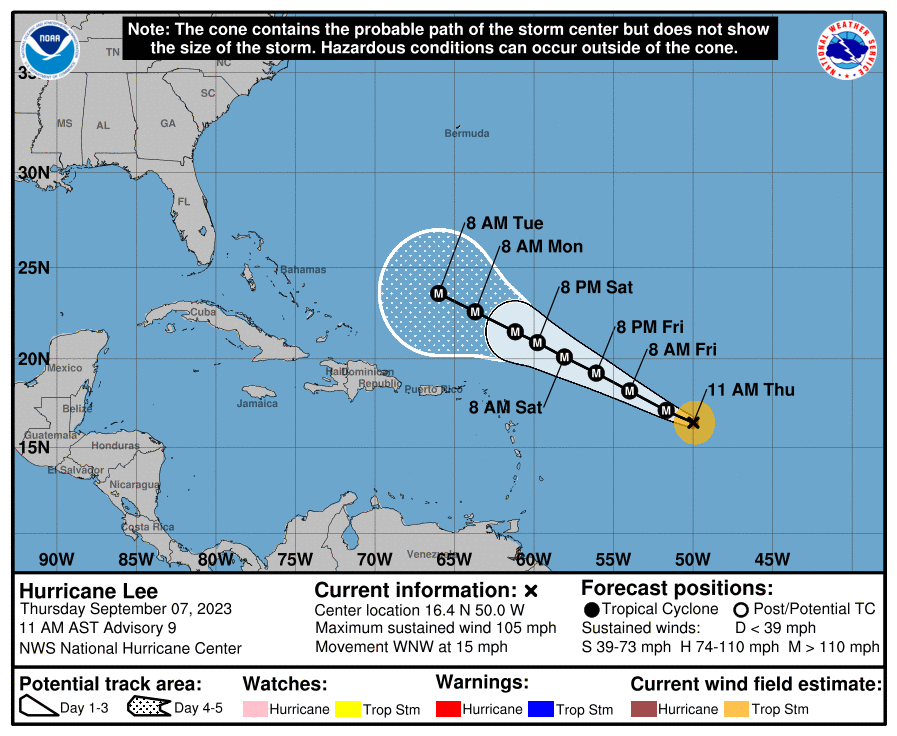
Wow, not only a Cat 2 now, with 105 mph winds, but a strong Cat 2 as Lee is in the midst of a rapid intensification cycle - at this rate will be Cat 4 (130 mph+) by late tonight and Cat 5 by Sunday, but will weaken some after that.

FORECAST POSITIONS AND MAX WINDS

INIT 07/1500Z 16.4N 50.0W 90 KT 105 MPH
12H 08/0000Z 17.1N 51.7W 115 KT 130 MPH
24H 08/1200Z 18.2N 54.0W 130 KT 150 MPH
36H 09/0000Z 19.2N 56.1W 140 KT 160 MPH
48H 09/1200Z 20.1N 58.1W 140 KT 160 MPH
60H 10/0000Z 20.9N 59.8W 135 KT 155 MPH
72H 10/1200Z 21.5N 61.2W 135 KT 155 MPH
96H 11/1200Z 22.6N 63.7W 125 KT 145 MPH
120H 12/1200Z 23.6N 66.0W 120 KT 140 MPH

yQYySnl.png
 
Last edited:
ADVERTISEMENT
ADVERTISEMENT