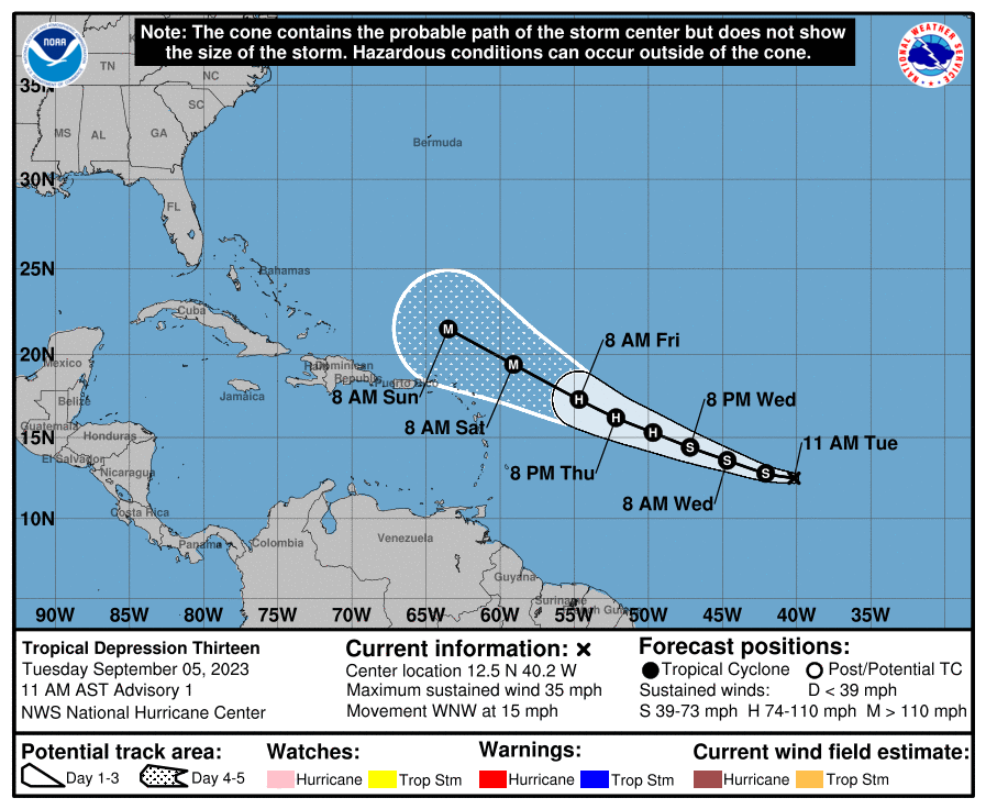
In honor of @e5fdny, starting this one early, since the post below has been in the tropical thread for hours, with zero comments and I'm pretty sure people will be interested in this one once it has its own thread. Anyway, as of 11 am this morning, Invest 95L became a tropical depression and will very likely soon become Tropical Storm Lee (it probably already is) - and it won't be long before future Lee becomes a hurricane and likely a major hurricane within 3-4 days. One doesn't often see a NHC forecast going from TD to major hurricane in 3 days and in fact, supposedly this is the first time an initial advisory had a storm becoming a Cat 4 hurricane, according to Tomer Burg (met). This is a testament to the abnormally warm ocean temps and the low shear, moist environment in the storm's path.
https://www.nhc.noaa.gov/graphics_at3.shtml?start#contents
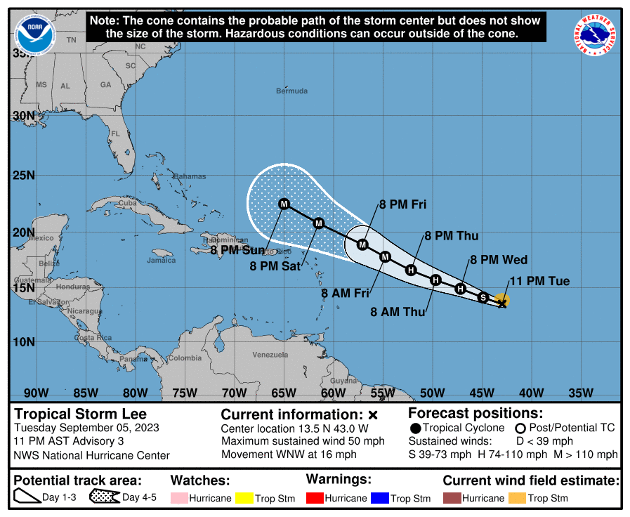
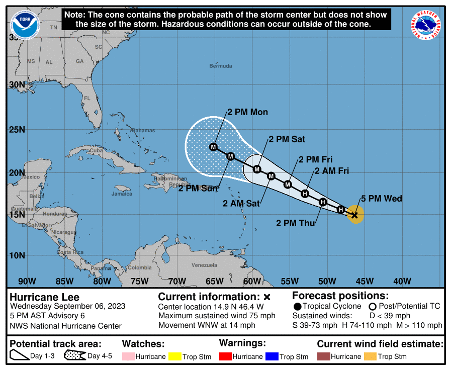
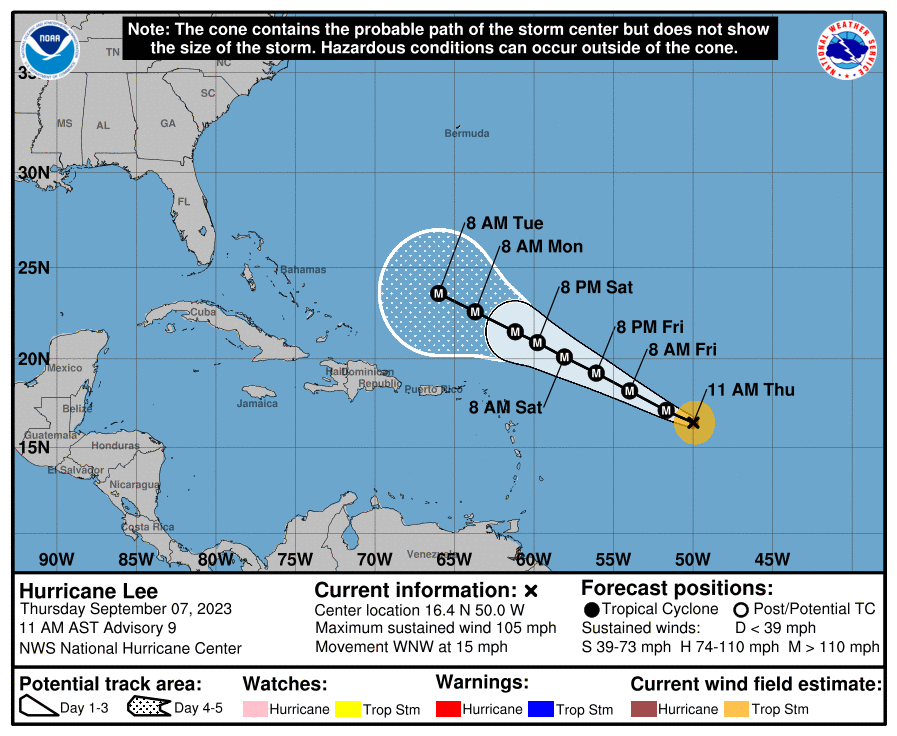
Best guess right now is that future Lee will head just north of the northern Leeward Islands and the Greater Antilles (PR/Hispaniola/Cuba) by Days 5-7 and then likely turn a bit towards the north, probably well east of the Bahamas and perhaps west of Bermuda and east of the US coast (like Franklin), but after that we're into Days 8-9 and beyond, where model divergence is too great for much confidence in the track.
Because of this high uncertainty, there is some chance (10-20%?) that the storm could strike the Canadian Maritimes and possibly even SE New England (which means eastern LI would be in play, too) and then Atlantic Canada. Obviously, if New England is possible, the rest of the east coast, including our area, has a small chance of also being possible, given how far out the storm is. Please don't pay attention to operational model forecast runs beyond Day 6-7 and especially at Day 10+ (today's 12Z GFS shows Lee grazing Cape Cod and Downeast Maine as a Cat 2 in 11-12 days), since they're generally garbage that far out and ensemble forecasts are better for looking at tracks. I'm sure social media will start buzzing with that GFS run shortly if not already.
Keep in mind that Irma in 2017, when it was at a similar longitude as future Lee is was expected to stay off the US east coast by most models/ensembles and most will remember that the storm actually hit northern Cuba, then rode up the western side of Florida - different setup than this storm, but the point is that 8+ day forecasts can be pretty far off.
Really good post on AmericanWx discussing some of the possibilities...
https://www.americanwx.com/bb/topic...ry-forthcoming/?do=findComment&comment=6994107
FORECAST POSITIONS AND MAX WINDS
INIT 05/1500Z 12.5N 40.2W 30 KT 35 MPH
12H 06/0000Z 12.8N 42.1W 40 KT 45 MPH
24H 06/1200Z 13.6N 44.7W 50 KT 60 MPH
36H 07/0000Z 14.4N 47.2W 60 KT 70 MPH
48H 07/1200Z 15.3N 49.7W 70 KT 80 MPH
60H 08/0000Z 16.2N 52.2W 80 KT 90 MPH
72H 08/1200Z 17.3N 54.7W 95 KT 110 MPH
96H 09/1200Z 19.4N 59.1W 115 KT 130 MPH
120H 10/1200Z 21.5N 63.5W 120 KT 140 MPH
https://www.nhc.noaa.gov/graphics_at3.shtml?start#contents
Best guess right now is that future Lee will head just north of the northern Leeward Islands and the Greater Antilles (PR/Hispaniola/Cuba) by Days 5-7 and then likely turn a bit towards the north, probably well east of the Bahamas and perhaps west of Bermuda and east of the US coast (like Franklin), but after that we're into Days 8-9 and beyond, where model divergence is too great for much confidence in the track.
Because of this high uncertainty, there is some chance (10-20%?) that the storm could strike the Canadian Maritimes and possibly even SE New England (which means eastern LI would be in play, too) and then Atlantic Canada. Obviously, if New England is possible, the rest of the east coast, including our area, has a small chance of also being possible, given how far out the storm is. Please don't pay attention to operational model forecast runs beyond Day 6-7 and especially at Day 10+ (today's 12Z GFS shows Lee grazing Cape Cod and Downeast Maine as a Cat 2 in 11-12 days), since they're generally garbage that far out and ensemble forecasts are better for looking at tracks. I'm sure social media will start buzzing with that GFS run shortly if not already.
Keep in mind that Irma in 2017, when it was at a similar longitude as future Lee is was expected to stay off the US east coast by most models/ensembles and most will remember that the storm actually hit northern Cuba, then rode up the western side of Florida - different setup than this storm, but the point is that 8+ day forecasts can be pretty far off.
Really good post on AmericanWx discussing some of the possibilities...
https://www.americanwx.com/bb/topic...ry-forthcoming/?do=findComment&comment=6994107
FORECAST POSITIONS AND MAX WINDS
INIT 05/1500Z 12.5N 40.2W 30 KT 35 MPH
12H 06/0000Z 12.8N 42.1W 40 KT 45 MPH
24H 06/1200Z 13.6N 44.7W 50 KT 60 MPH
36H 07/0000Z 14.4N 47.2W 60 KT 70 MPH
48H 07/1200Z 15.3N 49.7W 70 KT 80 MPH
60H 08/0000Z 16.2N 52.2W 80 KT 90 MPH
72H 08/1200Z 17.3N 54.7W 95 KT 110 MPH
96H 09/1200Z 19.4N 59.1W 115 KT 130 MPH
120H 10/1200Z 21.5N 63.5W 120 KT 140 MPH
Last edited: