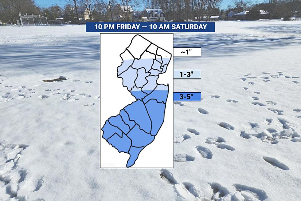
I wonder if this will affect the hockey games at MetLife?Dusting/coating at most for the Thursday night (after NW) clipper, so no impact really, but the Sat clipper has the potential for 1-2" (and up to 3" in spots) for the whole area (it'll be cold enough from 2 am to 10 am Sat when any snow would fall), as per the Euro, CMC, RGEM, Icon and NBM, while the GFS/NAM/UK have 1" or less generally.
And even just 1-2" with temps below freezing mostly falling at night will lead to slick untreated roads everywhere until things warm up a bit with the indirect sun. Probably be mostly gone by sunset, but the morning could be impacted. However, nada is still possible, so don't run out and get milk and bread yet; also, the ceiling for this event is probably 3-4", unlike this past storm where the ceiling was pretty high and was realized for many.
Maybe time for a thread? @e5fdny?


Colleges
- AAC
- ACC
- Big 12
- Big East
- Big Ten
- Pac-12
- SEC
- Atlantic 10
- Conference USA
- Independents
- Junior College
- Mountain West
- Sun Belt
- MAC
- More
- Navy
- UAB
- Tulsa
- UTSA
- Charlotte
- Florida Atlantic
- Temple
- Rice
- East Carolina
- USF
- SMU
- North Texas
- Tulane
- Memphis
- Miami
- Louisville
- Virginia
- Syracuse
- Wake Forest
- Duke
- Boston College
- Virginia Tech
- Georgia Tech
- Pittsburgh
- North Carolina
- North Carolina State
- Clemson
- Florida State
- Cincinnati
- BYU
- Houston
- Iowa State
- Kansas State
- Kansas
- Texas
- Oklahoma State
- TCU
- Texas Tech
- Baylor
- Oklahoma
- UCF
- West Virginia
- Wisconsin
- Penn State
- Ohio State
- Purdue
- Minnesota
- Iowa
- Nebraska
- Illinois
- Indiana
- Rutgers
- Michigan State
- Maryland
- Michigan
- Northwestern
- Arizona State
- Oregon State
- UCLA
- Colorado
- Stanford
- Oregon
- Arizona
- California
- Washington
- USC
- Utah
- Washington State
- Texas A&M
- Auburn
- Mississippi State
- Kentucky
- South Carolina
- Arkansas
- Florida
- Missouri
- Ole Miss
- Alabama
- LSU
- Georgia
- Vanderbilt
- Tennessee
- Louisiana Tech
- New Mexico State
- Middle Tennessee
- Western Kentucky
- UTEP
- Florida International University
High School
- West
- Midwest
- Northeast
- Southeast
- Other
- Alaska
- Arizona
- California
- Colorado
- Nevada
- New Mexico
- Northern California
- Oregon
- Southern California Preps
- Washington
- Edgy Tim
- Indiana
- Kansas
- Nebraska
- Iowa
- Michigan
- Minnesota
- Missouri
- Oklahoma Varsity
- Texas Basketball
- Texas
- Wisconsin
- Delaware
- Maryland
- New Jersey Basketball
- New Jersey
- New York City Basketball
- Ohio
- Pennsylvania
- Greater Cincinnati
- Virginia
- West Virginia Preps
ADVERTISEMENT
Install the app
How to install the app on iOS
Follow along with the video below to see how to install our site as a web app on your home screen.
Note: This feature may not be available in some browsers.
You are using an out of date browser. It may not display this or other websites correctly.
You should upgrade or use an alternative browser.
You should upgrade or use an alternative browser.
OT: Significant (CNJ) to Major (Along/N of 78) Winter Storm Likely on Tuesday (2/12-13; much less uncertainty on outcome)
- Thread starter RU848789
- Start date
They have done those games in snow before, haven't they? I seem to remember at least one.I wonder if this will affect the hockey games at MetLife?
Well "Philadelphia" technically had 3.5-4.5" in the two locations listed below, but I would say that's like judging Manhattan by the 8" reported in the northern Bronx when Central Park and JFG got 3-4". Those two Philly locations are in the much hillier sections of far NW Philly, as you know. The other 3 reports of 1" or less are not and likely reflective of what most of Philly got. Also, nobody got "hail" - that was sleet.Well let's not celebrate too much. You completely whiffed on Philadelphia 🤣🤣
The differences in this storm was amazing as big differences were just a few miles away from each other. Literally zero in the city except for car tops and elevated surfaces. About 5 miles away in Belmont Hills we got 3.5 inches remaining as of this morning. We started with hail at home. CC no hail. Just a degree or two can make a huge difference. Officially Philadelphia got .6 at the Airport.
And while that 14.4" number was from a model, not a prediction by me, I did say a few times that I thought Philly would likely get in the 2-5" range (and had the potential for more), as per the NWS advisory and that was wrong, as I'd say 95% of Philly got about an inch or so, just like adjacent SNJ across the river where snowfall was 1-1.5".
Good article on the snowfall gradient across Philly and why much less fell for 95% of Philly than was modeled. Kudos to the NWS, though, in not biting on the model consensus showing at least 6" for Philly the night before the storm and sticking with their 2-4" prediction for Philly/adjacent SNJ when they put out the advisories Monday evening. TWC was even further off as they had 3-5" for Philly/adjacent SNJ.
https://www.inquirer.com/weather/sn...r-storm-totals-weather-forecast-20240213.html
Philadelphia County...
Shawmont 4.5 in 1200 PM 02/13 Trained Spotter
1 NNW Manayunk 3.5 in 0100 PM 02/13 Public
Philadelphia 1.0 in 0900 AM 02/13 COCORAHS
Mantua 1.0 in 1205 PM 02/13 Public
Philadelphia International 0.6 in 0100 PM 02/13 ASOS
Nope, precip will be done by mid/late morning.I wonder if this will affect the hockey games at MetLife?
Where the heck is COCORAHS?Well "Philadelphia" technically had 3.5-4.5" in the two locations listed below, but I would say that's like judging Manhattan by the 8" reported in the northern Bronx when Central Park and JFG got 3-4". Those two Philly locations are in the much hillier sections of far NW Philly, as you know. The other 3 reports of 1" or less are not and likely reflective of what most of Philly got. Also, nobody got "hail" - that was sleet.
And while that 14.4" number was from a model, not a prediction by me, I did say a few times that I thought Philly would likely get in the 2-5" range (and had the potential for more), as per the NWS advisory and that was wrong, as I'd say 95% of Philly got about an inch or so, just like adjacent SNJ across the river where snowfall was 1-1.5".
Good article on the snowfall gradient across Philly and why much less fell for 95% of Philly than was modeled. Kudos to the NWS, though, in not biting on the model consensus showing at least 6" for Philly the night before the storm and sticking with their 2-4" prediction for Philly/adjacent SNJ when they put out the advisories Monday evening. TWC was even further off as they had 3-5" for Philly/adjacent SNJ.
https://www.inquirer.com/weather/sn...r-storm-totals-weather-forecast-20240213.html
Philadelphia County...
Shawmont 4.5 in 1200 PM 02/13 Trained Spotter
1 NNW Manayunk 3.5 in 0100 PM 02/13 Public
Philadelphia 1.0 in 0900 AM 02/13 COCORAHS
Mantua 1.0 in 1205 PM 02/13 Public
Philadelphia International 0.6 in 0100 PM 02/13 ASOS
The rest of the city has to have more right? And what did the Trevose spotter have? 14.4?? 🤣🤣🤣
I looked it up. It's the Community Collaborative Rain, Hail and Snow Network. Because every drop counts...COCORAHS is not a place it's an acronym.

All these numbers are bunk. All that matters is what a certain White Bus owner experienced in his front "yard" in Philadelphia ;)Well "Philadelphia" technically had 3.5-4.5" in the two locations listed below, but I would say that's like judging Manhattan by the 8" reported in the northern Bronx when Central Park and JFG got 3-4". Those two Philly locations are in the much hillier sections of far NW Philly, as you know. The other 3 reports of 1" or less are not and likely reflective of what most of Philly got. Also, nobody got "hail" - that was sleet.
And while that 14.4" number was from a model, not a prediction by me, I did say a few times that I thought Philly would likely get in the 2-5" range (and had the potential for more), as per the NWS advisory and that was wrong, as I'd say 95% of Philly got about an inch or so, just like adjacent SNJ across the river where snowfall was 1-1.5".
Good article on the snowfall gradient across Philly and why much less fell for 95% of Philly than was modeled. Kudos to the NWS, though, in not biting on the model consensus showing at least 6" for Philly the night before the storm and sticking with their 2-4" prediction for Philly/adjacent SNJ when they put out the advisories Monday evening. TWC was even further off as they had 3-5" for Philly/adjacent SNJ.
https://www.inquirer.com/weather/sn...r-storm-totals-weather-forecast-20240213.html
Philadelphia County...
Shawmont 4.5 in 1200 PM 02/13 Trained Spotter
1 NNW Manayunk 3.5 in 0100 PM 02/13 Public
Philadelphia 1.0 in 0900 AM 02/13 COCORAHS
Mantua 1.0 in 1205 PM 02/13 Public
Philadelphia International 0.6 in 0100 PM 02/13 ASOS
For? The only one I found was in Salt Lake City! 🤣🤣🤣COCORAHS is not a place it's an acronym.
So it's a made up place?I looked it up. It's the Community Collaborative Rain, Hail and Snow Network. Because every drop counts...
I think it's a weather observer group, not a place:So it's a made up place?
https://www.cocorahs.org/
You're being a bit obtuse, but you do have a point. COCORAHS is a cooperative data collecting effort for precipitation across the US and this report is very real. However, the problem is that the location provided isn't very helpful, as it says "Philadelphia 3.6 SSW" which means the location was 3.6 miles SSW of "Philadelphia" but they don't specify where in Philadelphia that is (probably CC).So it's a made up place?
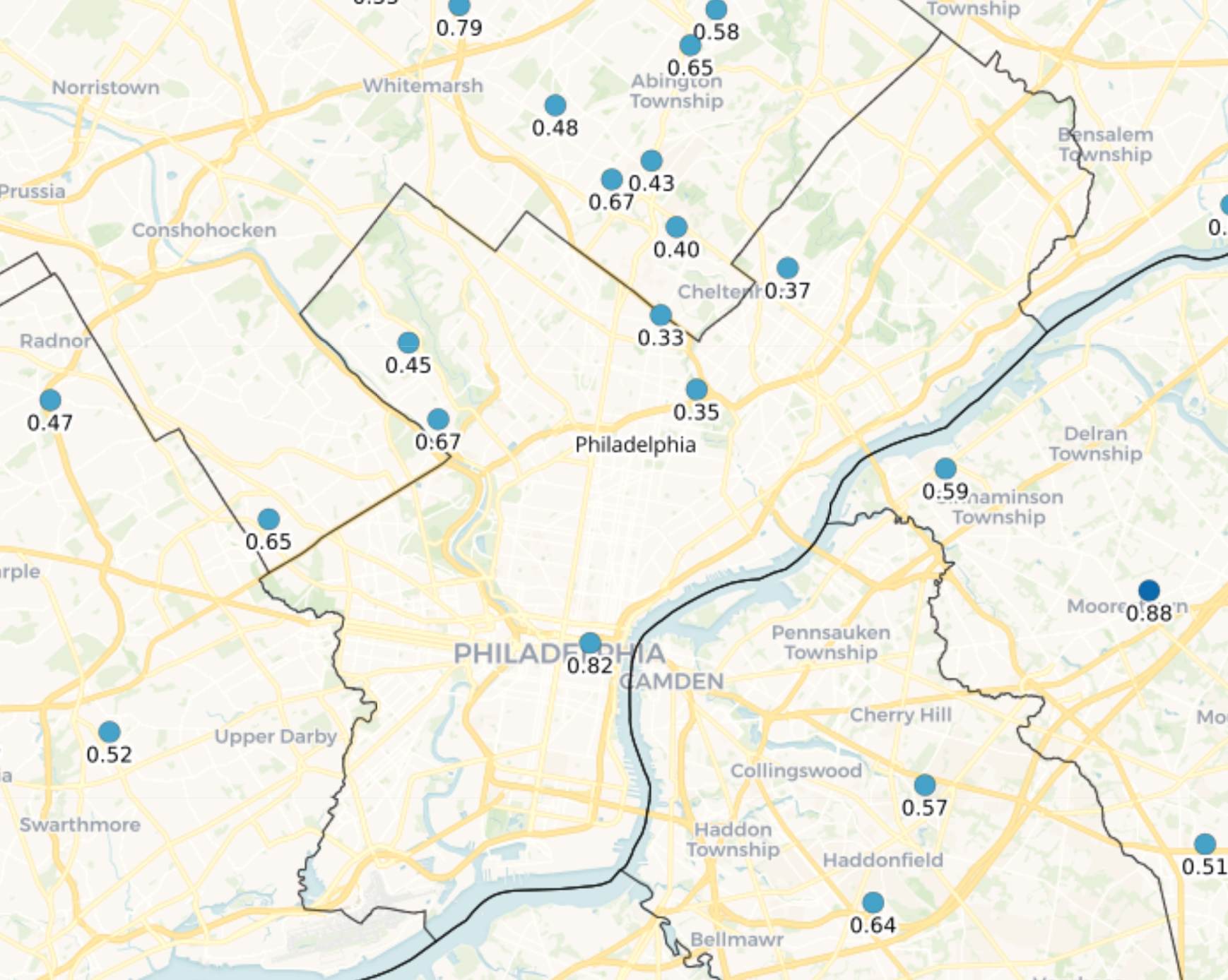
And yes, it is CC, since they do provide a map for each location and this one is the 0.82 entry on the map, which does, indeed, look like it's 3.6 miles SSW of CC. There is also a snowfall report of 2.6" from a location 1.3 miles SE of Rockledge (which is in Montco, but the point is in Philly). The map below shows precip amounts, not snowfall amounts and one has to click on the point to get a snowfall report if there is one. It's all kind of complicated and unclear to be honest.
https://www.cocorahs.org/ViewData/V...ReportID=0ac138d9-40ee-44e0-a373-5c143b5a693e
COCORAHS is a cooperative data collecting effort for precipitation
So is it a weather data commune?
A snowblower will never sully my property though - if I could ban one thing on the planet it would be all snowblowers, lol - they ruin the quiet perfection of freshly fallen snow.
Snowstorm hiking/snowhoeing/skiing or camping are great for that. Basically, just dump any sign of people in favor of snow.
I wasn't being obtuse. My point is if you aren't providing a place or neighborhood why is the NWS posting it? Philadelphia is a big city. I was interested in all the Philadelphia spots to see where the dropoff line was. Agree its unclear.You're being a bit obtuse, but you do have a point. COCORAHS is a cooperative data collecting effort for precipitation across the US and this report is very real. However, the problem is that the location provided isn't very helpful, as it says "Philadelphia 3.6 SSW" which means the location was 3.6 miles SSW of "Philadelphia" but they don't specify where in Philadelphia that is (probably CC).
And yes, it is CC, since they do provide a map for each location and this one is the 0.82 entry on the map, which does, indeed, look like it's 3.6 miles SSW of CC. There is also a snowfall report of 2.6" from a location 1.3 miles SE of Rockledge (which is in Montco, but the point is in Philly). The map below shows precip amounts, not snowfall amounts and one has to click on the point to get a snowfall report if there is one. It's all kind of complicated and unclear to be honest.
https://www.cocorahs.org/ViewData/V...ReportID=0ac138d9-40ee-44e0-a373-5c143b5a693e
You're being a bit obtuse, but you do have a point. COCORAHS is a cooperative data collecting effort for precipitation across the US and this report is very real. However, the problem is that the location provided isn't very helpful, as it says "Philadelphia 3.6 SSW" which means the location was 3.6 miles SSW of "Philadelphia" but they don't specify where in Philadelphia that is (probably CC).
And yes, it is CC, since they do provide a map for each location and this one is the 0.82 entry on the map, which does, indeed, look like it's 3.6 miles SSW of CC. There is also a snowfall report of 2.6" from a location 1.3 miles SE of Rockledge (which is in Montco, but the point is in Philly). The map below shows precip amounts, not snowfall amounts and one has to click on the point to get a snowfall report if there is one. It's all kind of complicated and unclear to be honest.
https://www.cocorahs.org/ViewData/V...ReportID=0ac138d9-40ee-44e0-a373-5c143b5a693e
I wasn't being obtuse. My point is if you aren't providing a place or neighborhood why is the NWS posting it? Philadelphia is a big city. I was interested in all the Philadelphia spots to see where the dropoff line was. Agree its unclear.
His word not mine just to be clear. Funny thing is nobody was able to answer the question. So...
I did answer the question for the location of the COCORAHS report and showed everything anyone needed to know about those reports, but I absolutely agree that the NWS needs to do better with snowfall report locations and I've given them that feedback in the past, but no change yet. Maybe I'll try again.His word not mine just to be clear. Funny thing is nobody was able to answer the question. So...
I searched (obviously not well enough!)
Again, not blaming you at all.I searched (obviously not well enough!)
This is good example of why I’m not a fan of the “trends” type threads on here someone else is so fond of. Since things can get lost.
You had a great post and some very needed info.
Storm/event over, thread over…
Thanks, I did not take it as blaming and I have to agree with your opinion on separate threads. I have now posted Zarrow's map on the correct thread.Again, not blaming you at all.
This is good example of why I’m not a fan of the “trends” type threads on here someone else is so fond of. Since things can get lost.
You had a great post and some very needed info.
Storm/event over, thread over…
He posted in the wrong event thread not the pattern thread, so your premise is incorrect here. Also, the current thread was at the top of the page, so not sure how it was missed.Again, not blaming you at all.
This is good example of why I’m not a fan of the “trends” type threads on here someone else is so fond of. Since things can get lost.
You had a great post and some very needed info.
Storm/event over, thread over…
What's your call on this thing? Not that it's a big deal just curious if it will over-perform. Seems like people's snow maps have been ticking up.He posted in the wrong event thread not the pattern thread, so your premise is incorrect here. Also, the current thread was at the top of the page, so not sure how it was missed.
See, now someone else did it again, @RU848789What's your call on this thing? Not that it's a big deal just curious if it will over-perform. Seems like people's snow maps have been ticking up.
As @RUPete is asking about the event and not the trend.
So I’m not wrong…trend thread bad, event thread good.
@RUPete - new weather thread
The constant bickering on weather threads is too much for me. I will unwatch this one and be sure not to click on future ones.
There's no bickering in the 5 other places l post weather info. I imagine you could guess why.The constant bickering on weather threads is too much for me. I will unwatch this one and be sure not to click on future ones.
If you look at the next two weeks I'm going to say yes! He nailed it!So does this jibe with what the groundhog predicted?
If you look at the next two weeks I'm going to say yes! He nailed it!
I've heard @mildone isn't allowed anywhere near when the groundhog is making his prediction. Something about him nailing the groundhog?
Which is over.Are you yanking my chain now? This is NOT the trend thread, it's the event thread for 2/13.
But you get my drift…snow drift. LOL
Your point is crystal clear, but you were clearly wrong about this being the trend thread. At least own that.Which is over.
But you get my drift…snow drift. LOL
Your point is crystal clear, but you were clearly wrong about this being the trend thread. At least own that.
So he's not trending in the right direction?
That’s what the “snow drift” mention was for…mea culpa. 🙂Your point is crystal clear, but you were clearly wrong about this being the trend thread. At least own that.
I had a groundhog living in my yard for years. Kept itself hidden most of the time, but could see it running around now and then. Sadly, about 3-4 months back or so, it crawled out onto my front walk where it sat for a couple/few days barely moving then died. My kid tried to get animal control out to check on it when it was clear it wasn't doing well. But they never showed up. 🙁I've heard @mildone isn't allowed anywhere near when the groundhog is making his prediction. Something about him nailing the groundhog?
I understand. I really wish the moderators would do *much* more to "moderate." But they don't. This is the only place I have access to your information and, as valuable as it is, I'm just worn out from the constant attempts at oneupsmanship, let alone the gratuitously nasty comments that go back and forth.There's no bickering in the 5 other places l post weather info. I imagine you could guess why.
Similar threads
- Replies
- 62
- Views
- 2K
OT: Minor to Moderate (2-4?) Snowfall Likely Sat morning (2/17); will be <32F, so expect slick roads
- Replies
- 213
- Views
- 5K
- Replies
- 477
- Views
- 12K
- Replies
- 592
- Views
- 15K
- Replies
- 771
- Views
- 20K
ADVERTISEMENT
ADVERTISEMENT