The latest NAM run is great for snow lovers. 4-8 inches across much of NJ.
Will the other 0z models follow?
Will the other 0z models follow?


Follow along with the video below to see how to install our site as a web app on your home screen.
Note: This feature may not be available in some browsers.
First thing I looked at after getting home from that incredible win at the RAC tonight. Still fired up.The latest NAM run is great for snow lovers. 4-8 inches across much of NJ.
Will the other 0z models follow?
I remember in the 80’s going to wrestling practice in a blizzard. Today they would fire the coach for making us attendIn 1988 it wouldnt but 2024 most likely postponed
First thing I looked at after getting home from that incredible win at the RAC tonight. Still fired up.
The game, lol - see my thread on the hoops board. The NAM run was pretty nice, though...Fired up from the hoops game? Or the nam run? lol. Or both?

Hot off the presses, the NWS-Philly upped snowfall forecasts again. As I said elsewhere, I'm astounded by this, as the 12Z (and previous runs) Euro, UK, and GFS generally have 1-2" for this storm (even using Kuchera), while only the NAM, CMC and SREFs have more than 3" anywhere. I know they know way more about meteorology than anyone here, but this is unusual. At least the NBM (model blend) is much greater than the GFS/UK/Euro and not far below the NBM, but I don't recall seeing 3 of the 4 major globals discounted at this range.
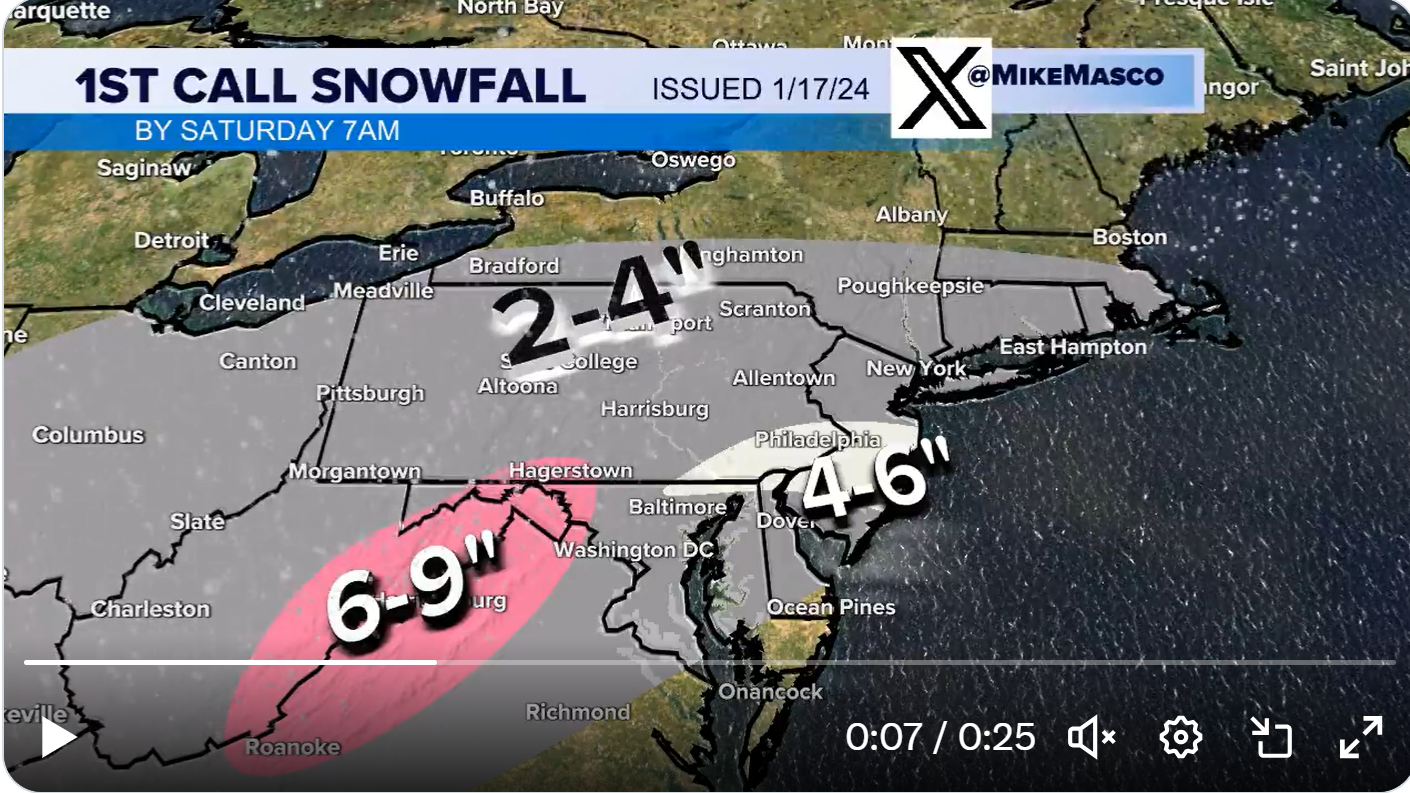
Edit - well, maybe not so aggressive, lol. Mike Masco just came out with his first call and it's pretty bullish, especially from about 10 miles N of 195/276 and southward almost to Delaware Bay, where he has a 4-6" swath from the inverted trough, mainly, as per the graphic, below.
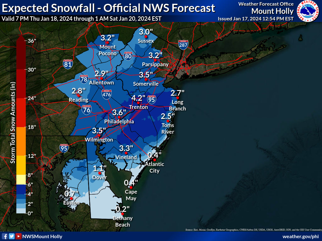
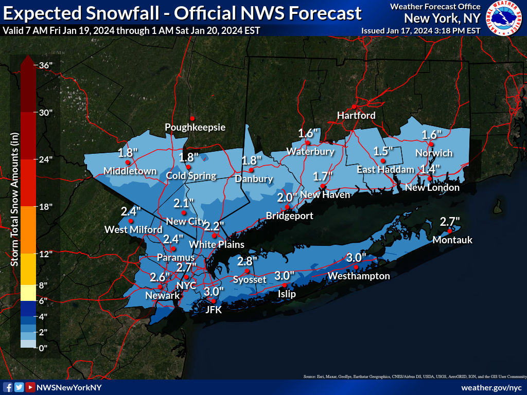
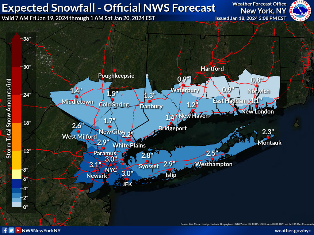
Edit #2: NWS-NYC also just upped their snowfall forecasts by about an inch across the board vs. this morning, with 2-3" for NYC and most of SENY (below the Tappan Zee) and 3-4" for extreme southern NYC and southern LI.


Main snowfall should be between about 7 am and 7 pm, roughly, with some fairly light snow a few hours before and after that window. Here's the hourly weather graphic for NB, which should suffice for most of CNJ.What is the window for when this snow is going to fall in Somerset County?

Prediction for school closures in monmouth county?Main snowfall should be between about 7 am and 7 pm, roughly, with some fairly light snow a few hours before and after that window. Here's the hourly weather graphic for NB, which should suffice for most of CNJ.
As I said earlier, I'm skeptical of the high amounts from the NWS-Philly, but in fact, they just tweaked their forecast even slightly higher for many. Sounds like the key here, from reading the boards (and answers to a couple of questions of mine) is that it's likely they (and other forecasters showing 3-6" amounts for much of our area) are giving more credence to the high resolution models, like the NAM3K, the HRRR, the WRF, etc., as they believe that mesoscale banding, which is expected in an inverted trough situation like this, will be better forecasted by high resolution models using smaller grid spacing (the globals generally have 9-13 km grid spacing while the high res models typically are in the 2-4 km range).Nam and Rgem are just 2-3 inches in NJ with Euro/gfs 1-2
Mt holly obviously going higher to cover their asses for where the norlun trough sets up...a likely narrow path that overacheives with 4-5 inch amounts. Figuring where that sets up is almost impossible to pin down


Decent probability as Monmouth has been in the bullseye for highest amounts in many models, although it's very possible they'll hedge and do early dismissal, as roads probably won't be bad at all at 6 am when most make their decisions.Prediction for school closures in monmouth county?
well the nams especially the 3k did cut back significantly at 12zAs I said earlier, I'm skeptical of the high amounts from the NWS-Philly, but in fact, they just tweaked their forecast even slightly higher for many. Sounds like the key here, from reading the boards (and answers to a couple of questions of mine) is that it's likely they (and other forecasters showing 3-6" amounts for much of our area) are giving more credence to the high resolution models, like the NAM3K, the HRRR, the WRF, etc., as they believe that mesoscale banding, which is expected in an inverted trough situation like this, will be better forecasted by high resolution models using smaller grid spacing (the globals generally have 9-13 km grid spacing while the high res models typically are in the 2-4 km range).
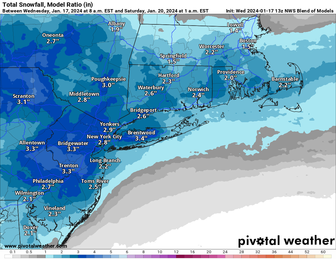
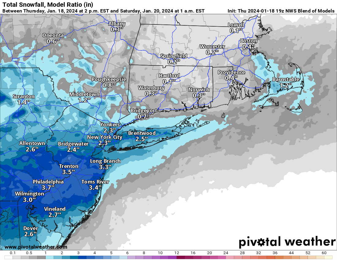
And these high res models have generally been showing greater snowfall amounts than the global models, as indicated best by the HREF model, which combines a host of high-res model output from several high res models and and is showing 4-6" for most of our region south of 80 down through most of SNJ/SEPA with 2-4" outside that area. That's the best I can do to figure out why the NWS-Philly forecast is a fair amount snowier than the global models, which are generally showing 1-3".
I honestly don't know what to expect as I just don't know enough about the detailed modeling and how these folks use the various models and how they weight them to get their forecasts, but I remain skeptical that most of the area will be getting 3-6" - I think that area will likely be much smaller than the NWS is showing and it seems more likely that will be close to 276/195 with more like 2-4" for most of CNJ, which is why I'm going with 3.3" prediction for my house (similar to the NBM). We'll see soon...
overall should be about a 12-15 hour storm, gfs has it only about 12 while the nam had it starting earlier and ending later.
yesSo............ do I get gas for the snowblower or not down here in Burlington County?
Yes.So............ do I get gas for the snowblower or not down here in Burlington County?
Yes.Yes.
Dammit, what happened? Went from rain event earlier yesterday to 3.5-5" in South Monmouth. Plugged in the electric start on the snowblower, gassed it up for first time in 3 years(?), and it fired right up, so we have that going for us. @e5fdny and @koleszar -your snowblowers in the ready position?
Still have 1" to 3" in Howell so I'm going to gamble on this one as well. So I'm going to be a maverick here and live life on the edge.Yes.
Dammit, what happened? Went from rain event earlier yesterday to 3.5-5" in South Monmouth. Plugged in the electric start on the snowblower, gassed it up for first time in 3 years(?), and it fired right up, so we have that going for us. @e5fdny and @koleszar -your snowblowers in the ready position?
I'd come over with my snowblower in the back of my pickup but:Still have 1" to 3" in Howell so I'm going to gamble on this one as well. So I'm going to be a maverick here and live life on the edge.
As I said earlier, I'm skeptical of the high amounts from the NWS-Philly, but in fact, they just tweaked their forecast even slightly higher for many. Sounds like the key here, from reading the boards (and answers to a couple of questions of mine) is that it's likely they (and other forecasters showing 3-6" amounts for much of our area) are giving more credence to the high resolution models, like the NAM3K, the HRRR, the WRF, etc., as they believe that mesoscale banding, which is expected in an inverted trough situation like this, will be better forecasted by high resolution models using smaller grid spacing (the globals generally have 9-13 km grid spacing while the high res models typically are in the 2-4 km range).
And these high res models have generally been showing greater snowfall amounts than the global models, as indicated best by the HREF model, which combines a host of high-res model output from several high res models and and is showing 4-6" for most of our region south of 80 down through most of SNJ/SEPA with 2-4" outside that area. That's the best I can do to figure out why the NWS-Philly forecast is a fair amount snowier than the global models, which are generally showing 1-3".
I honestly don't know what to expect as I just don't know enough about the detailed modeling and how these folks use the various models and how they weight them to get their forecasts, but I remain skeptical that most of the area will be getting 3-6" - I think that area will likely be much smaller than the NWS is showing and it seems more likely that will be close to 276/195 with more like 2-4" for most of CNJ, which is why I'm going with 3.3" prediction for my house (similar to the NBM). We'll see soon...
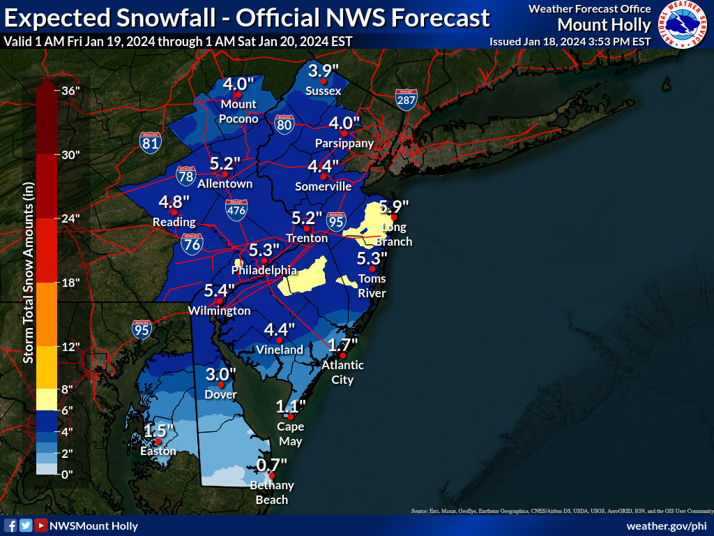
Still not buying more than 3" anywhere north of 78; the higher amounts south of there, especially near 195 and south of there make sense assuming that's where the best inverted trough banding sets up.18z nam wasnt good for snow lovers north of 78
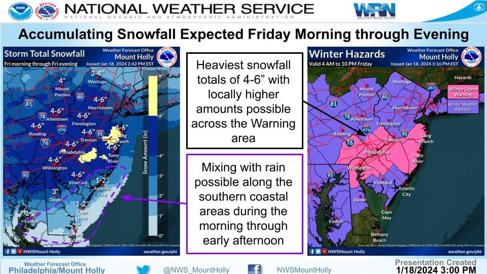
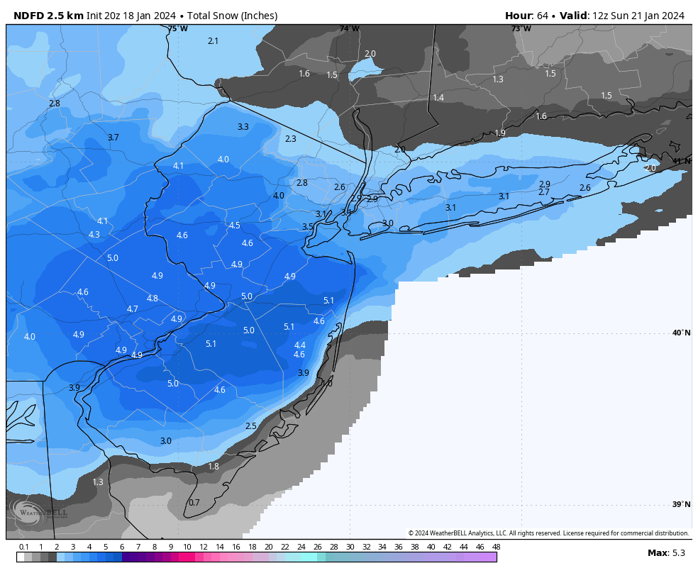
Meanwhile mt holly has winter storm warnings now for monmouth ocean burlington 4-7 inches
Did you say electric start!?!?!Yes.
Dammit, what happened? Went from rain event earlier yesterday to 3.5-5" in South Monmouth. Plugged in the electric start on the snowblower, gassed it up for first time in 3 years(?), and it fired right up, so we have that going for us. @e5fdny and @koleszar -your snowblowers in the ready position?
Am I seeing a 6-8 pocket?
Dan Zarrow on 107.1 the boss says "the coast" will get mixing and closer to 1". Blow some of that warm coastal air West towards us over here. I'm going to fill the 5 gallon tank in a bit.Maybe I didn’t buy enough gas.🤷♂️
You don't fill it with sunshine, like your truck?Dan Zarrow on 107.1 the boss says "the coast" will get mixing and closer to 1". Blow some of that warm coastal air West towards us over here. I'm going to fill the 5 gallon tank in a bit.
Tried that--could not get the electrons into the carburetor. Working on a new invention.You don't fill it with sunshine, like your truck?
