Fair points, but La Nina is over and every model is showing a phase/capture of the upper low and the surface low, with resulting heavy snow to the NW of the surface low (and especially the 700 mbar low). The big question is where/when does that occur. If it's close to us like the 12Z NAM showed, we'll get the CCB and snow even at the coast; if not, it's white rain mostly, but for areas along/N of 80 they won't have to rely on the CCB as much and with temps below 32F overnight, they'll accumulate, so I think you're underestimating the snow NW of say 287/80. We'll see. Also, no soundings right now are showing any sleet signature - it's all just snow aloft with temps above 32F from the surface to maybe 1000-2000 feet and how deep that is will lead to either snow, wet snow or rain.The 1000mb easterly jet will be stronger than models think as per almost all events this year and will keep snow totals down to virtually nil south of 80 and only minor to moderate accumulations (4-6) in higher elevations of Sussex and Warren. Does not help that SSTs off the coast are warmer than normal for that easterly fetch.
Unfortunately a deepening storm will actually increase this jet until the low is well northeast of NJ, preventing the column from cooling all the way to the surface. 850s scream snowstorm, 1000mb says you will get nothing and like it, maybe some sleet mixed it.
La Nina plus a very strong mid-atl subtropical ridge has been the death knell for models this year. They struggle with each independently, put them together and they pump out mumbo jumbo.


Colleges
- AAC
- ACC
- Big 12
- Big East
- Big Ten
- Pac-12
- SEC
- Atlantic 10
- Conference USA
- Independents
- Junior College
- Mountain West
- Sun Belt
- MAC
- More
- Navy
- UAB
- Tulsa
- UTSA
- Charlotte
- Florida Atlantic
- Temple
- Rice
- East Carolina
- USF
- SMU
- North Texas
- Tulane
- Memphis
- Miami
- Louisville
- Virginia
- Syracuse
- Wake Forest
- Duke
- Boston College
- Virginia Tech
- Georgia Tech
- Pittsburgh
- North Carolina
- North Carolina State
- Clemson
- Florida State
- Cincinnati
- BYU
- Houston
- Iowa State
- Kansas State
- Kansas
- Texas
- Oklahoma State
- TCU
- Texas Tech
- Baylor
- Oklahoma
- UCF
- West Virginia
- Wisconsin
- Penn State
- Ohio State
- Purdue
- Minnesota
- Iowa
- Nebraska
- Illinois
- Indiana
- Rutgers
- Michigan State
- Maryland
- Michigan
- Northwestern
- Arizona State
- Oregon State
- UCLA
- Colorado
- Stanford
- Oregon
- Arizona
- California
- Washington
- USC
- Utah
- Washington State
- Texas A&M
- Auburn
- Mississippi State
- Kentucky
- South Carolina
- Arkansas
- Florida
- Missouri
- Ole Miss
- Alabama
- LSU
- Georgia
- Vanderbilt
- Tennessee
- Louisiana Tech
- New Mexico State
- Middle Tennessee
- Western Kentucky
- UTEP
- Florida International University
High School
- West
- Midwest
- Northeast
- Southeast
- Other
- Alaska
- Arizona
- California
- Colorado
- Nevada
- New Mexico
- Northern California
- Oregon
- Southern California Preps
- Washington
- Edgy Tim
- Indiana
- Kansas
- Nebraska
- Iowa
- Michigan
- Minnesota
- Missouri
- Oklahoma Varsity
- Texas Basketball
- Texas
- Wisconsin
- Delaware
- Maryland
- New Jersey Basketball
- New Jersey
- New York City Basketball
- Ohio
- Pennsylvania
- Greater Cincinnati
- Virginia
- West Virginia Preps
ADVERTISEMENT
Install the app
How to install the app on iOS
Follow along with the video below to see how to install our site as a web app on your home screen.
Note: This feature may not be available in some browsers.
You are using an out of date browser. It may not display this or other websites correctly.
You should upgrade or use an alternative browser.
You should upgrade or use an alternative browser.
OT: Major Winter Storm 3/13-14 (Mixed Bag/High Uncertainty) and 3/10-11 (over)
- Thread starter RU848789
- Start date
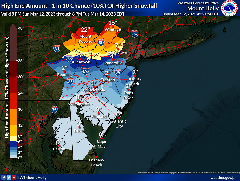
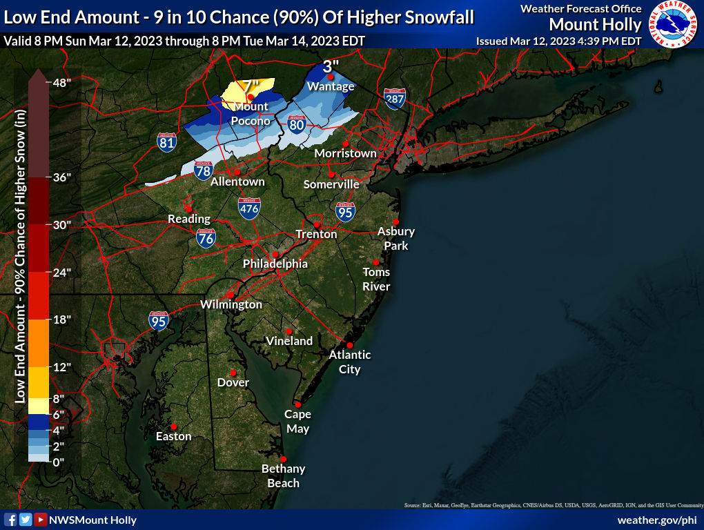
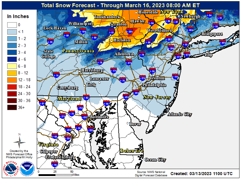
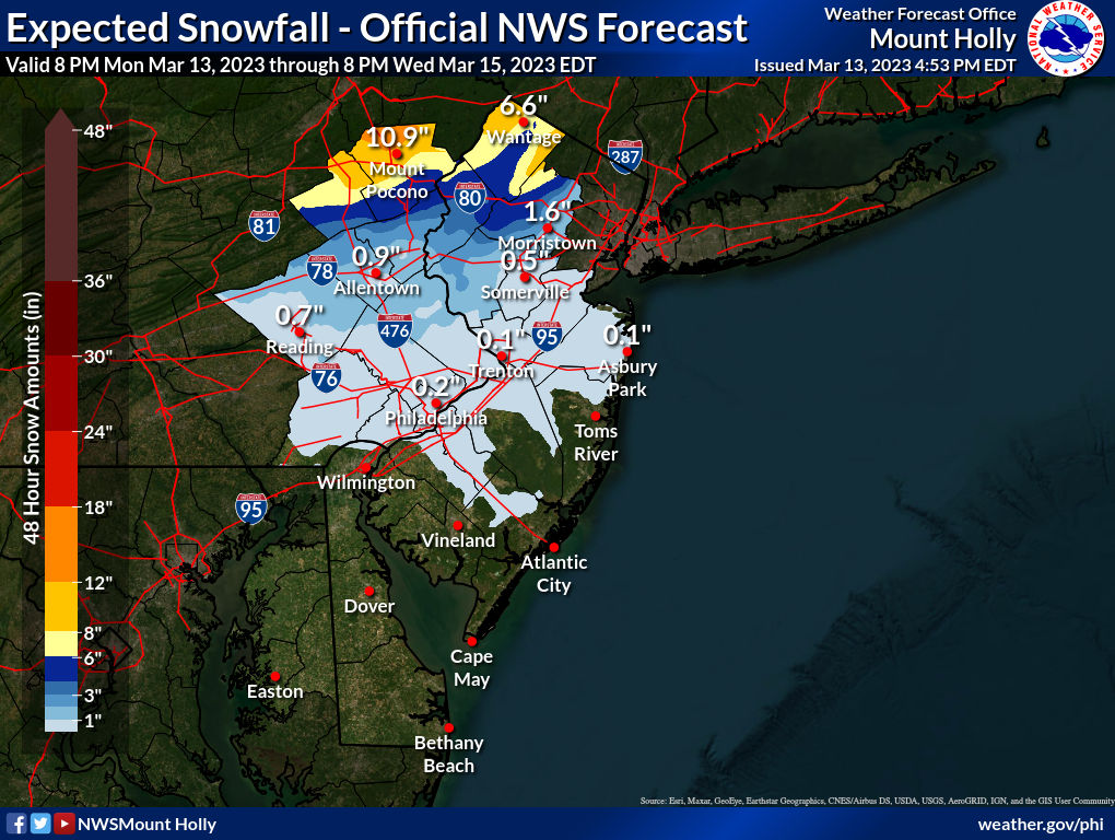
And if anyone wants to see the insane ranges the NWS considerss possible, below are the maps of the 10% chance of high and low snowfalls. This is why forecasting this storm is so hard...

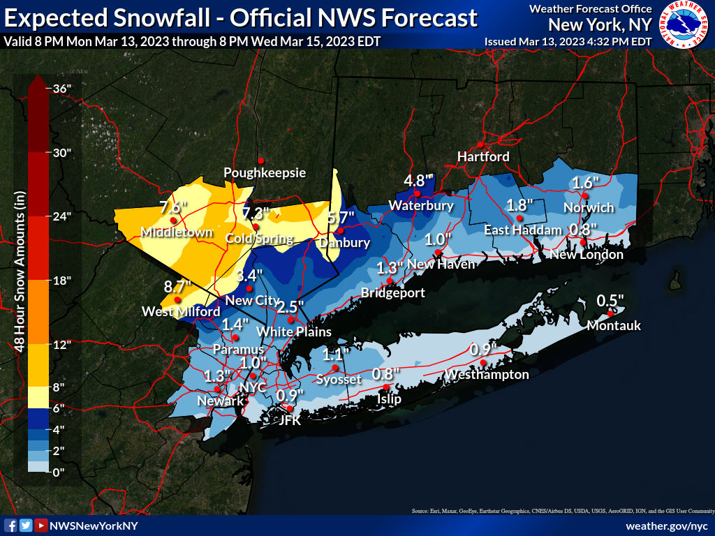
That's brief?? War and Peace was brief compared to this! 🤣Got stuff to do, so this will be brief. NWS-Philly kept all of the same watches, but increased snowfall amounts in the watch areas (Carbon/Monroe - Poconos - and Sussex) to 6-12", while the NWS-NYC kept the watches for NW Passaic, Orange/Putnam, but increased amounts to 6-10", plus they expanded the watches to include all of SE Passaic, NW Bergen and Rockland/N Westchester for 4-7" of snow. No advisories are up yet, since we're still 30+ hours away from any change to snow (plus I think the offices are simply praying we'll have more clarity on the storm by then with tonight's 0Z models, since the models are still all over the place. I don't envy the NWS here.
I expect we'll see the watches converted to warnings and a bunch of advisories issued with the 4 am package for maybe 2-4/3-6" amounts for the next tier of counties, like the Lehigh Valley, Warren/Morris and SE Bergen/Essex and southern Westchester. not sure if we'll also see advisories for Hunterdon/Somerset (probably) and Union, Hudson and NYC/LI (maybe). Also, updated maps are below and as often happens, we have a discontinuity between offices, as snowfall forecasts by the NWS-NYC are for 1-2" for Essex/Union/SI, but neighboring Morris/Somerset/Middlesex all have <1" forecast by the NWS-Philly. For almost everyone, there will be rain throughout tomorrow (up to 1/2" by evening) with the expected changeover to snow starting in the far NW areas and moving SE overnight, such that the heaviest snow to the N/NW would be from maybe 1-2 am to early afternoon Tuesday and maybe just after sunrise for places that don't get much snow - and some of the snow that falls during the day will melt, making accumulations tough without high rates.
The 18Z suite of models just started coming out and the NAM-12km backed off hugely from the bomb it showed 6 hours ago with only a few inches of snow for CNJ/NYC/S of 78 (a lot more north of there still), while the 3km NAM (which is better with convection and some think convection is screwing up the models) shows 6-12" for most of CNJ/NYC and a lot more N of there. This is essentially the same friggin' model with the 3km NAM having higher resolution (tighter grid spacing) and a different way of analyzing convection and that seems like it was enough to have them with totally different outcomes, which is very rare. My guess is we don't have consensus even tonight, the way this is going. So if this blows up and becomes a big snowstorm, most won't be prepared, plus absolutely no snow along/S of 78 and all rain is still a viable solution. The only good thing about the models showing an easterly low track with less snow is that they also have a lot less precip (maybe only 1-1.5" vs. up to 3"), so flooding would be a lot less likely. High winds and minor coastal flooding is also likely regardless of the snow/rain debate.
https://www.weather.gov/phi/
Tell me you've never read Tolstoy without telling me you've never read Tolstoy.That's brief?? War and Peace was brief compared to this! 🤣
"A man is like a fraction whose numerator is what he is and whose denominator is what he thinks of himself. The larger the denominator, the smaller the fraction."Tell me you've never read Tolstoy without telling me you've never read Tolstoy.
Leo Tolstoy
Good description of the guy who asked me the question.
Last edited:
All of tonight's 0Z models, but two, are now showing only minor snowfall accumulations (1-2") for areas along/S of 78 in PA/NJ (i.e., most of CNJ) on into NYC/LI, with a couple of models showing <1". These models also have cut back even for the 80 corridor (2=5") with only areas N of 80 up to 84 getting maybe 5-10". Areas N of 84 are still getting 8"+ from these models. Also, the models showing only minor snowfall are also showing a lot less precip than earlier today or yesterday, due to their more easterly track towards Maine, with most of NJ now only getting up to 1" of total liquid equivalent precip, so urban/stream flooding and coastal flooding concerns have lessened. The two exceptions are the NAM 3km and NAM 12km models, which are still showing 4-8" for much of CNJ/NYC/LI and 12" plus along and N of 80 (and up to 2" of total precip).Got stuff to do, so this will be brief. NWS-Philly kept all of the same watches, but increased snowfall amounts in the watch areas (Carbon/Monroe - Poconos - and Sussex) to 6-12", while the NWS-NYC kept the watches for NW Passaic, Orange/Putnam, but increased amounts to 6-10", plus they expanded the watches to include all of SE Passaic, NW Bergen and Rockland/N Westchester for 4-7" of snow. No advisories are up yet, since we're still 30+ hours away from any change to snow (plus I think the offices are simply praying we'll have more clarity on the storm by then with tonight's 0Z models, since the models are still all over the place. I don't envy the NWS here.
I expect we'll see the watches converted to warnings and a bunch of advisories issued with the 4 am package for maybe 2-4/3-6" amounts for the next tier of counties, like the Lehigh Valley, Warren/Morris and SE Bergen/Essex and southern Westchester. not sure if we'll also see advisories for Hunterdon/Somerset (probably) and Union, Hudson and NYC/LI (maybe). Also, updated maps are below and as often happens, we have a discontinuity between offices, as snowfall forecasts by the NWS-NYC are for 1-2" for Essex/Union/SI, but neighboring Morris/Somerset/Middlesex all have <1" forecast by the NWS-Philly. For almost everyone, there will be rain throughout tomorrow (up to 1/2" by evening) with the expected changeover to snow starting in the far NW areas and moving SE overnight, such that the heaviest snow to the N/NW would be from maybe 1-2 am to early afternoon Tuesday and maybe just after sunrise for places that don't get much snow - and some of the snow that falls during the day will melt, making accumulations tough without high rates.
The 18Z suite of models just started coming out and the NAM-12km backed off hugely from the bomb it showed 6 hours ago with only a few inches of snow for CNJ/NYC/S of 78 (a lot more north of there still), while the 3km NAM (which is better with convection and some think convection is screwing up the models) shows 6-12" for most of CNJ/NYC and a lot more N of there. This is essentially the same friggin' model with the 3km NAM having higher resolution (tighter grid spacing) and a different way of analyzing convection and that seems like it was enough to have them with totally different outcomes, which is very rare. My guess is we don't have consensus even tonight, the way this is going. So if this blows up and becomes a big snowstorm, most won't be prepared, plus absolutely no snow along/S of 78 and all rain is still a viable solution. The only good thing about the models showing an easterly low track with less snow is that they also have a lot less precip (maybe only 1-1.5" vs. up to 3"), so flooding would be a lot less likely. High winds and minor coastal flooding is also likely regardless of the snow/rain debate.
https://www.weather.gov/phi/
Given the fragility of the setup and the variability we've seen across models and in run-to-run within the same models and the fact that several very good pros on 33andrain are still hedging on cutting back snowfall forecasts due to the NAM 3km and NAM 12km still showing significant snows for CNJ/NYC/LI (and a lot more N of there), they're not quite ready to throw in the towel, but they acknowledge getting more than a minor snowfall for CNJ/NYC/LI is looking unlikely. I'd even expect to see the NWS cut back on snowfall forecasts S of 78 and maybe S of 80 a bit. We'll see in the am - I'd say if we don't see any changes back to significant snowfall by tomorrow's 12Z runs, then this will be largely a rainstorm for areas S of 78/CNJ/NYC/LI and possibly even up to 80.
I guess it's just not our winter - even the snow that areas along/S of 78 into NYC are supposed to get is forecast to fall after sunrise on Tuesday with temps in the mid-30s at light to moderate intensity, meaning it'll likely be white rain that doesn't accumulate much. First RU gets effed and now this, lol.
Last edited:
It's raining. I think they can cut back the snow totals, now.

@bac2therac wins again.All of tonight's 0Z models, but two, are now showing only minor snowfall accumulations (1-2") for areas along/S of 78 in PA/NJ (i.e., most of CNJ) on into NYC/LI, with a couple of models showing <1". These models also have cut back even for the 80 corridor (2=5") with only areas N of 80 up to 84 getting maybe 5-10". Areas N of 84 are still getting 8"+ from these models. Also, the models showing only minor snowfall are also showing a lot less precip than earlier today or yesterday, due to their more easterly track towards Maine, with most of NJ now only getting up to 1" of total liquid equivalent precip, so urban/stream flooding and coastal flooding concerns have lessened. The two exceptions are the NAM 3km and NAM 12km models, which are still showing 4-8" for much of CNJ/NYC/LI and 12" plus along and N of 80 (and up to 2" of total precip).
Given the fragility of the setup and the variability we've seen across models and in run-to-run within the same models and the fact that several very good pros on 33andrain are still hedging on cutting back snowfall forecasts due to the NAM 3km and NAM 12km still showing significant snows for CNJ/NYC/LI (and a lot more N of there), they're not quite ready to throw in the towel, but they acknowledge getting more than a minor snowfall for CNJ/NYC/LI is looking unlikely. I'd even expect to see the NWS cut back on snowfall forecasts S of 78 and maybe S of 80 a bit. We'll see in the am - I'd say if we don't see any changes back to significant snowfall by tomorrow's 12Z runs, then this will be largely a rainstorm for areas S of 78/CNJ/NYC/LI and possibly even up to 80.
I guess it's just not our winter - even the snow that areas along/S of 78 into NYC are supposed to get is forecast to fall after sunrise on Tuesday with temps in the mid-30s at light to moderate intensity, meaning it'll likely be white rain that doesn't accumulate much. First RU gets effed and now this, lol.
Got stuff to do, so this will be brief. NWS-Philly kept all of the same watches, but increased snowfall amounts in the watch areas (Carbon/Monroe - Poconos - and Sussex) to 6-12", while the NWS-NYC kept the watches for NW Passaic, Orange/Putnam, but increased amounts to 6-10", plus they expanded the watches to include all of SE Passaic, NW Bergen and Rockland/N Westchester for 4-7" of snow. No advisories are up yet, since we're still 30+ hours away from any change to snow (plus I think the offices are simply praying we'll have more clarity on the storm by then with tonight's 0Z models, since the models are still all over the place. I don't envy the NWS here.
I expect we'll see the watches converted to warnings and a bunch of advisories issued with the 4 am package for maybe 2-4/3-6" amounts for the next tier of counties, like the Lehigh Valley, Warren/Morris and SE Bergen/Essex and southern Westchester. not sure if we'll also see advisories for Hunterdon/Somerset (probably) and Union, Hudson and NYC/LI (maybe). Also, updated maps are below and as often happens, we have a discontinuity between offices, as snowfall forecasts by the NWS-NYC are for 1-2" for Essex/Union/SI, but neighboring Morris/Somerset/Middlesex all have <1" forecast by the NWS-Philly. For almost everyone, there will be rain throughout tomorrow (up to 1/2" by evening) with the expected changeover to snow starting in the far NW areas and moving SE overnight, such that the heaviest snow to the N/NW would be from maybe 1-2 am to early afternoon Tuesday and maybe just after sunrise for places that don't get much snow - and some of the snow that falls during the day will melt, making accumulations tough without high rates.
The 18Z suite of models just started coming out and the NAM-12km backed off hugely from the bomb it showed 6 hours ago with only a few inches of snow for CNJ/NYC/S of 78 (a lot more north of there still), while the 3km NAM (which is better with convection and some think convection is screwing up the models) shows 6-12" for most of CNJ/NYC and a lot more N of there. This is essentially the same friggin' model with the 3km NAM having higher resolution (tighter grid spacing) and a different way of analyzing convection and that seems like it was enough to have them with totally different outcomes, which is very rare. My guess is we don't have consensus even tonight, the way this is going. So if this blows up and becomes a big snowstorm, most won't be prepared, plus absolutely no snow along/S of 78 and all rain is still a viable solution. The only good thing about the models showing an easterly low track with less snow is that they also have a lot less precip (maybe only 1-1.5" vs. up to 3"), so flooding would be a lot less likely. High winds and minor coastal flooding is also likely regardless of the snow/rain debate.
https://www.weather.gov/phi/
Summary: A very powerful nor'easter is taking shape off the NC coast, which will be enhanced by an upper level approaching from our west leading to heavy precip from this afternoon through mid-morning tomorrow (and later in New England), with lighter precip after that through Tuesday night. Some bulleted highlights below.All of tonight's 0Z models, but two, are now showing only minor snowfall accumulations (1-2") for areas along/S of 78 in PA/NJ (i.e., most of CNJ) on into NYC/LI, with a couple of models showing <1". These models also have cut back even for the 80 corridor (2=5") with only areas N of 80 up to 84 getting maybe 5-10". Areas N of 84 are still getting 8"+ from these models. Also, the models showing only minor snowfall are also showing a lot less precip than earlier today or yesterday, due to their more easterly track towards Maine, with most of NJ now only getting up to 1" of total liquid equivalent precip, so urban/stream flooding and coastal flooding concerns have lessened. The two exceptions are the NAM 3km and NAM 12km models, which are still showing 4-8" for much of CNJ/NYC/LI and 12" plus along and N of 80 (and up to 2" of total precip).
Given the fragility of the setup and the variability we've seen across models and in run-to-run within the same models and the fact that several very good pros on 33andrain are still hedging on cutting back snowfall forecasts due to the NAM 3km and NAM 12km still showing significant snows for CNJ/NYC/LI (and a lot more N of there), they're not quite ready to throw in the towel, but they acknowledge getting more than a minor snowfall for CNJ/NYC/LI is looking unlikely. I'd even expect to see the NWS cut back on snowfall forecasts S of 78 and maybe S of 80 a bit. We'll see in the am - I'd say if we don't see any changes back to significant snowfall by tomorrow's 12Z runs, then this will be largely a rainstorm for areas S of 78/CNJ/NYC/LI and possibly even up to 80.
I guess it's just not our winter - even the snow that areas along/S of 78 into NYC are supposed to get is forecast to fall after sunrise on Tuesday with temps in the mid-30s at light to moderate intensity, meaning it'll likely be white rain that doesn't accumulate much. First RU gets effed and now this, lol.
- Heavy snow for everyone N of 84 in PA/NY/New England (1-2 feet)
- Heavy rain (1-2") for everyone along/S of 78 in PA/NJ and into NENJ/NYC/LI rain with these locations getting ~1" (2" in spots) of snow during the day on Tuesday (much will melt),
- The snow gradient from 78 to 84 and in elevation, everywhere will be extremely steep.
- Warnings are up for 6-12" of snow for Poconos/Sussex and the western Hudson Valley (12-16" above 1000')
- Warnings are up for 4-8" in Warren/Morris/W. Passaic, noting parts of these counties will likely only get 2-4" of snow and parts could get up to 10" of snow at the higher elevations.
- Advisories are up for 2-5" of snow for E. Passaic/NW Bergen and Rockland/N. Westchester.
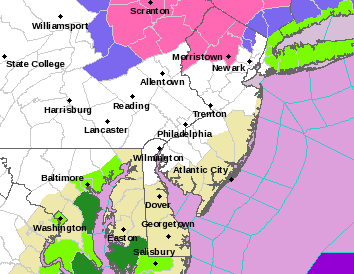
- See the map for warnings (pink counties) and advisories (blue).
- No coastal flood or wind advisories have been issued.
Much of this heavy snow will come between midnight (when today's rain changes to snow for these areas) and 10 am. Almost everyone will get 1/2" to 1" of rain before the changeover to snow and areas forecast to get minimal snow will be getting 1-2" of rain from now through Tuesday, with the heaviest rain from this afternoon through about 8-10 am Tuesday, when the rain will likely finally change to some snow for most folks. The problem with that is that by then the intensity will be lower and the temps will be in the low/mid 30s with the high March sun angle, which will all combine to likely keep snowfall under an inch (maybe 2" in spots) for areas along/S of 78, extending into NE NJ (Union/Essex/Hudson and southern Bergen) and NYC/LI. Obviously, looking at the map, those are some very steep gradients in snowfall, so uncertainty is high and the potential for the forecast to bust either high or low on snowfall amounts is much higher than usual. This is where nowcasting - watching the radars and looking out the window - will become important tonight into Tuesday.
The decrease in total precip for our area (to 1-2" total liquid equivalent precip) relative to forecasts a day or two ago should likely preclude much urban/stream flooding. Similarly, the primary low being much further east than originally thought should mean only scattered minor coastal flooding and a bit less windy conditions, with no advisories up (yet), although gusts could reach 45 mph at the coast. This is still a very powerful storm - just not the significant snowstorm for the 95 corridor and areas along/S of 78 that was being advertised a few days ago. It's been that kind of winter around here.
https://www.americanwx.com/bb/topic/58993-march-13-14th-noreaster-threat/page/44/
https://www.weather.gov/phi/
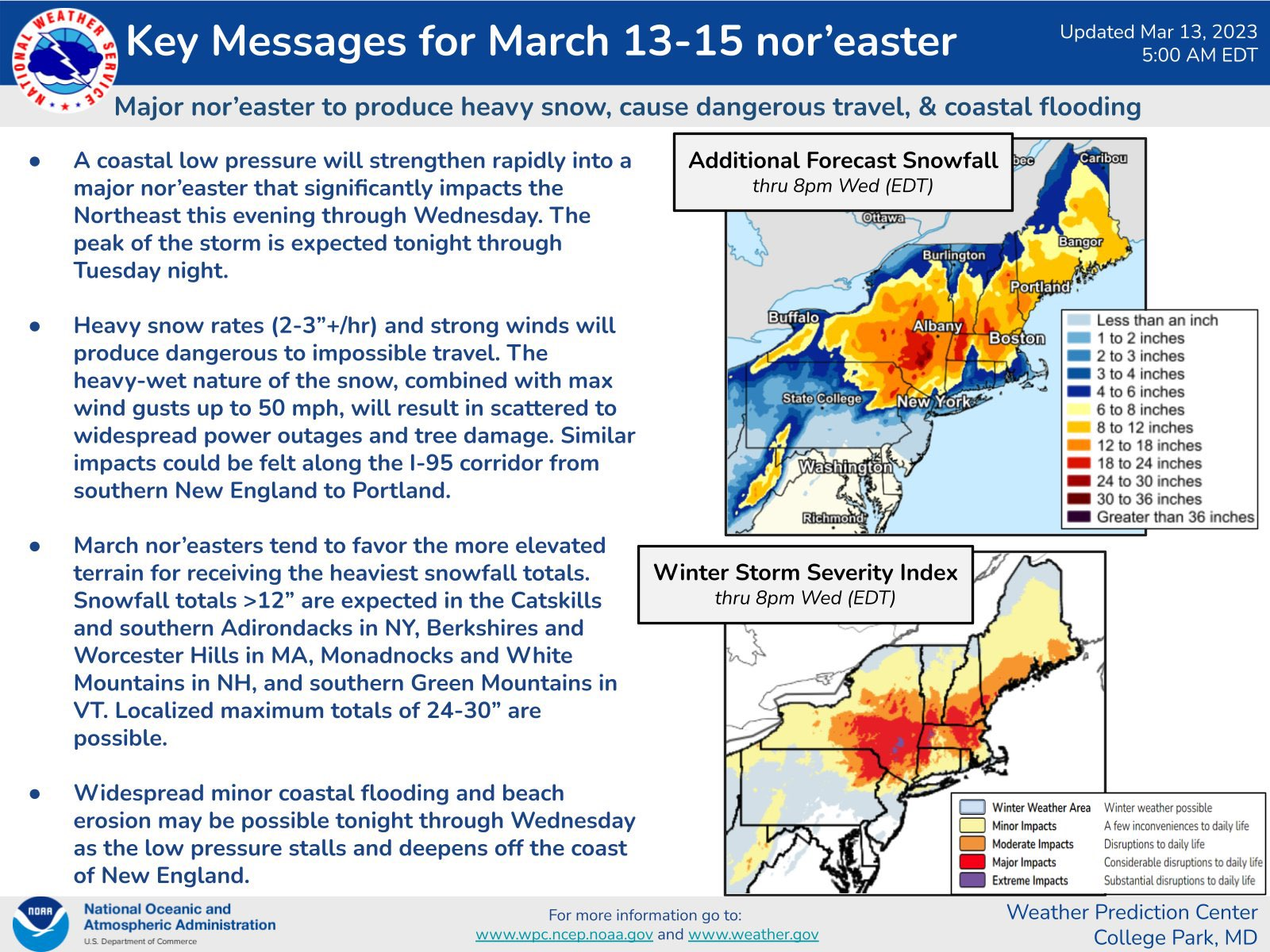
Have a little hope, #s. Belmar-Farmingdale forecast from NWS:Summary: A very powerful nor'easter is taking shape off the NC coast, which will be enhanced by an upper level approaching from our west leading to heavy precip from this afternoon through mid-morning tomorrow (and later in New England), with lighter precip after that through Tuesday night. Some bulleted highlights below.
Details: So, the NAMs finally caved to the other guidance this morning, as there is now decent consensus on moving the primary low much further NE towards well east of Cape Cod and then kind of stalling and retrograding somewhat towards Maine. This results in the nor'easter pummeling eastern NY and interior New England with 1-2 feet of snow (up to 3 feet in the higher elevations) with the heavy snow shield extending just into the northern and NW parts of our area with 6-12" of snow for the Poconos (with 12-18" there at over 1000'), Sussex County and the western Hudson Valley, and with areas like western Morris, northern Warren and NW Passaic getting up to 8" of snow, so warnings are up for the Poconos, Sussex, Warren, Morris, NW Passaic and Orange/Putnam (although eastern Morris and southern Warren will likely only get 2-5").
- Heavy snow for everyone N of 84 in PA/NY/New England (1-2 feet)
- Heavy rain (1-2") for everyone along/S of 78 in PA/NJ and into NENJ/NYC/LI rain with these locations getting ~1" (2" in spots) of snow during the day on Tuesday (much will melt),
- The snow gradient from 78 to 84 and in elevation, everywhere will be extremely steep.
- Warnings are up for 6-12" of snow for Poconos/Sussex and the western Hudson Valley (12-16" above 1000')
- Warnings are up for 4-8" in Warren/Morris/W. Passaic, noting parts of these counties will likely only get 2-4" of snow and parts could get up to 10" of snow at the higher elevations.
- Advisories are up for 2-5" of snow for E. Passaic/NW Bergen and Rockland/N. Westchester.
- See the map for warnings (pink counties) and advisories (blue).
- No coastal flood or wind advisories have been issued.
Much of this heavy snow will come between midnight (when today's rain changes to snow for these areas) and 10 am. Almost everyone will get 1/2" to 1" of rain before the changeover to snow and areas forecast to get minimal snow will be getting 1-2" of rain from now through Tuesday, with the heaviest rain from this afternoon through about 8-10 am Tuesday, when the rain will likely finally change to some snow for most folks. The problem with that is that by then the intensity will be lower and the temps will be in the low/mid 30s with the high March sun angle, which will all combine to likely keep snowfall under an inch (maybe 2" in spots) for areas along/S of 78, extending into NE NJ (Union/Essex/Hudson and southern Bergen) and NYC/LI. Obviously, looking at the map, those are some very steep gradients in snowfall, so uncertainty is high and the potential for the forecast to bust either high or low on snowfall amounts is much higher than usual. This is where nowcasting - watching the radars and looking out the window - will become important tonight into Tuesday.
The decrease in total precip for our area (to 1-2" total liquid equivalent precip) relative to forecasts a day or two ago should likely preclude much urban/stream flooding. Similarly, the primary low being much further east than originally thought should mean only scattered minor coastal flooding and a bit less windy conditions, with no advisories up (yet), although gusts could reach 45 mph at the coast. This is still a very powerful storm - just not the significant snowstorm for the 95 corridor and areas along/S of 78 that was being advertised a few days ago. It's been that kind of winter around here.
https://www.americanwx.com/bb/topic/58993-march-13-14th-noreaster-threat/page/44/
https://www.weather.gov/phi/
Today
Rain. High near 44. East wind 10 to 15 mph. Chance of precipitation is 90%. New precipitation amounts between a quarter and half of an inch possible.
Tonight
Rain. Low around 34. East wind around 15 mph becoming northwest after midnight. Chance of precipitation is 100%. New precipitation amounts between 1 and 2 inches possible.
Tuesday
Rain and snow, becoming all rain after 2pm. High near 39. Windy, with a west wind 20 to 30 mph, with gusts as high as 40 mph. Chance of precipitation is 90%. New snow accumulation of less than a half inch possible.
Tuesday Night
Rain likely before 8pm, then a chance of rain and snow between 8pm and 2am, then a slight chance of snow after 2am. Mostly cloudy, with a low around 32. Windy, with a northwest wind 25 to 30 mph, with gusts as high as 40 mph. Chance of precipitation is 60%. New snow accumulation of less than a half inch possible.
Summary: A very powerful nor'easter is taking shape off the NC coast, which will be enhanced by an upper level approaching from our west leading to heavy precip from this afternoon through mid-morning tomorrow (and later in New England), with lighter precip after that through Tuesday night. Some bulleted highlights below.
Details: So, the NAMs finally caved to the other guidance this morning, as there is now decent consensus on moving the primary low much further NE towards well east of Cape Cod and then kind of stalling and retrograding somewhat towards Maine. This results in the nor'easter pummeling eastern NY and interior New England with 1-2 feet of snow (up to 3 feet in the higher elevations) with the heavy snow shield extending just into the northern and NW parts of our area with 6-12" of snow for the Poconos (with 12-18" there at over 1000'), Sussex County and the western Hudson Valley, and with areas like western Morris, northern Warren and NW Passaic getting up to 8" of snow, so warnings are up for the Poconos, Sussex, Warren, Morris, NW Passaic and Orange/Putnam (although eastern Morris and southern Warren will likely only get 2-5").
- Heavy snow for everyone N of 84 in PA/NY/New England (1-2 feet)
- Heavy rain (1-2") for everyone along/S of 78 in PA/NJ and into NENJ/NYC/LI rain with these locations getting ~1" (2" in spots) of snow during the day on Tuesday (much will melt),
- The snow gradient from 78 to 84 and in elevation, everywhere will be extremely steep.
- Warnings are up for 6-12" of snow for Poconos/Sussex and the western Hudson Valley (12-16" above 1000')
- Warnings are up for 4-8" in Warren/Morris/W. Passaic, noting parts of these counties will likely only get 2-4" of snow and parts could get up to 10" of snow at the higher elevations.
- Advisories are up for 2-5" of snow for E. Passaic/NW Bergen and Rockland/N. Westchester.
- See the map for warnings (pink counties) and advisories (blue).
- No coastal flood or wind advisories have been issued.
Much of this heavy snow will come between midnight (when today's rain changes to snow for these areas) and 10 am. Almost everyone will get 1/2" to 1" of rain before the changeover to snow and areas forecast to get minimal snow will be getting 1-2" of rain from now through Tuesday, with the heaviest rain from this afternoon through about 8-10 am Tuesday, when the rain will likely finally change to some snow for most folks. The problem with that is that by then the intensity will be lower and the temps will be in the low/mid 30s with the high March sun angle, which will all combine to likely keep snowfall under an inch (maybe 2" in spots) for areas along/S of 78, extending into NE NJ (Union/Essex/Hudson and southern Bergen) and NYC/LI. Obviously, looking at the map, those are some very steep gradients in snowfall, so uncertainty is high and the potential for the forecast to bust either high or low on snowfall amounts is much higher than usual. This is where nowcasting - watching the radars and looking out the window - will become important tonight into Tuesday.
The decrease in total precip for our area (to 1-2" total liquid equivalent precip) relative to forecasts a day or two ago should likely preclude much urban/stream flooding. Similarly, the primary low being much further east than originally thought should mean only scattered minor coastal flooding and a bit less windy conditions, with no advisories up (yet), although gusts could reach 45 mph at the coast. This is still a very powerful storm - just not the significant snowstorm for the 95 corridor and areas along/S of 78 that was being advertised a few days ago. It's been that kind of winter around here.
https://www.americanwx.com/bb/topic/58993-march-13-14th-noreaster-threat/page/44/
https://www.weather.gov/phi/

You an always celebrate the 30th anniversary, @RU848789
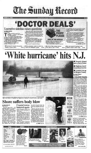
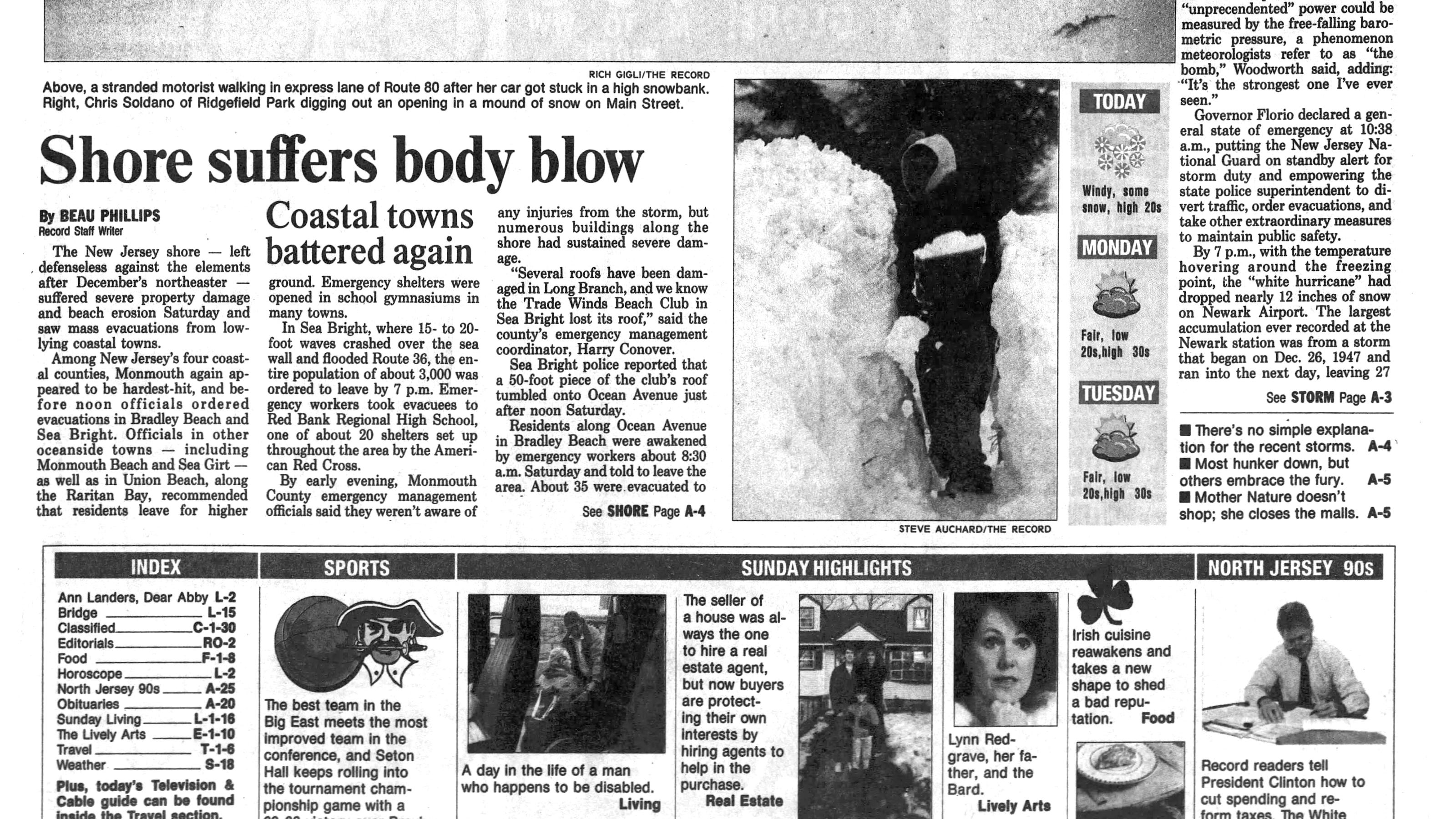
"Winter was winter in those days," said regional meteorologist Jim Witt.
"Much of the state saw more than a foot of snow from what remains one of the most powerful storms ever to hit the state, according to Jeffrey Morrison of the New Jersey Weather Observers network."
"Winter was winter in those days," said regional meteorologist Jim Witt.
"Much of the state saw more than a foot of snow from what remains one of the most powerful storms ever to hit the state, according to Jeffrey Morrison of the New Jersey Weather Observers network."
A look back: 'Storm of the Century' turns 30
The March 13, 1993, superstorm that shook the East Coast poured more than a foot of snow across many portions of North Jersey.
www.app.com
I'm taking nothing for granted. Way back when our first HS golf match of the year around 4/1 was postponed by a bit of snow and ice the night before. Then maybe 20 or so years ago the 1st week of MLB in the NE was postponed by a big storm.
That was an all-time bomb.You an always celebrate the 30th anniversary, @RU848789
"Winter was winter in those days," said regional meteorologist Jim Witt.
"Much of the state saw more than a foot of snow from what remains one of the most powerful storms ever to hit the state, according to Jeffrey Morrison of the New Jersey Weather Observers network."
A look back: 'Storm of the Century' turns 30
The March 13, 1993, superstorm that shook the East Coast poured more than a foot of snow across many portions of North Jersey.www.app.com
I believe this was the last storm to phase all 3 branches of the North American jetstream but I could be wrong. I think the temperature in CNJ dropped to like 4 degrees either during or immediately after the storm. Can you imagine if we had temps that low nowadays in March? The whole northeast would keel over.
Although it's been an above average winter temp wise. Most of 2023 has been miserable. It's either rain. Gloomy and damp. Or cloudy and windy. They are talking about sustained wins from 25-30mph and gusts to 40mph tomorrow. Thankfully I don't work Thursday so I'll enjoy a second sunny and beautiful day off with temps above 50. There hasn't been many of them so far in 2023.
We had a surprise snow-sleet event last night into this morning, up above Boone NC. Couple inches. Thankfully it's melting nicely on the roads (gravel). But temps will fall later, so refreezing and icy spots expected. Low temps thru Thursday. Can make for "exciting/wide-eyed" driving conditions traversing the switchbacks. All in all, though, not a very snowy winter.
30-40mph and higher gusts have become the norm around here the last couple years.Although it's been an above average winter temp wise. Most of 2023 has been miserable. It's either rain. Gloomy and damp. Or cloudy and windy. They are talking about sustained wins from 25-30mph and gusts to 40mph tomorrow. Thankfully I don't work Thursday so I'll enjoy a second sunny and beautiful day off with temps above 50. There hasn't been many of them so far in 2023.
Calm conditions are the thing of the past. 10-15mph is the new "calm"30-40mph and higher gusts have become the norm around here the last couple years.
There's no snow yet in the Poconos as today's races went off well.
Monticello has already called off tomorrow's card.
No word yet in from Saratoga.
Monticello has already called off tomorrow's card.
No word yet in from Saratoga.
There's no snow yet in the Poconos as today's races went off well.
Monticello has already called off tomorrow's card.
No word yet in from Saratoga.
They should run horse races in a foot of snow. That would be wild.
That would something like us trying to tailgate in the Yellow Lot during that 2011 WVU snowstorm! 😂They should run horse races in a foot of snow. That would be wild.
Don’t go there Mr. Dennis aka 1984, don’t go there! 😩😁Or the difference between VWUs offense in the first half snow and the 2nd half plowed field
My sincerest apologies. But if you ever need a photographic lesson of how not to plow a football field I have an album I created from that day including beautiful before and afters.. of course including shots of the scoreboard.Don’t go there Mr. Dennis aka 1984, don’t go there! 😩😁
Update. The NWS-Philly cut back a fair amount on snowfall forecasts for NWNJ/Poconos, although they retained the warnings, but with lower totals, i.e., Sussex/Warren/Morris still have warnings, but the amounts are for 2-8" (was 6-8"), which are highly elevation dependent (esp in Warren/Morris), and Carbon/Monroe (Poconos) still have warnings, but for 4-12" (was 6-12" with 12-18" lollipops), as these areas simply aren't forecast to get as much precip after the change to snow tonight. On the flip side, the NWS-NYC raised their warnings for W. Passaic/Orange/Putnam from 6-8" to 6-12" and retained advisories for NW Bergen, SE Passaic and Rockland/N. Westchester for 2-6" (noting 5-7" above 500'). The heaviest snow/precip will likely be from about 10 pm tonight through about 10 am tomorrow. Also, note that snowfall should be 12"+ for most N of 84 in PA/NY/interior New England, with ski resorts likely getting 18-30".Summary: A very powerful nor'easter is taking shape off the NC coast, which will be enhanced by an upper level approaching from our west leading to heavy precip from this afternoon through mid-morning tomorrow (and later in New England), with lighter precip after that through Tuesday night. Some bulleted highlights below.
Details: So, the NAMs finally caved to the other guidance this morning, as there is now decent consensus on moving the primary low much further NE towards well east of Cape Cod and then kind of stalling and retrograding somewhat towards Maine. This results in the nor'easter pummeling eastern NY and interior New England with 1-2 feet of snow (up to 3 feet in the higher elevations) with the heavy snow shield extending just into the northern and NW parts of our area with 6-12" of snow for the Poconos (with 12-18" there at over 1000'), Sussex County and the western Hudson Valley, and with areas like western Morris, northern Warren and NW Passaic getting up to 8" of snow, so warnings are up for the Poconos, Sussex, Warren, Morris, NW Passaic and Orange/Putnam (although eastern Morris and southern Warren will likely only get 2-5").
- Heavy snow for everyone N of 84 in PA/NY/New England (1-2 feet)
- Heavy rain (1-2") for everyone along/S of 78 in PA/NJ and into NENJ/NYC/LI rain with these locations getting ~1" (2" in spots) of snow during the day on Tuesday (much will melt),
- The snow gradient from 78 to 84 and in elevation, everywhere will be extremely steep.
- Warnings are up for 6-12" of snow for Poconos/Sussex and the western Hudson Valley (12-16" above 1000')
- Warnings are up for 6-8" in Warren/Morris/W. Passaic, noting parts of these counties will likely only get 2-4" of snow and parts could get up to 10" of snow at the higher elevations.
- Advisories are up for 2-5" of snow for E. Passaic/NW Bergen and Rockland/N. Westchester.
- See the map for warnings (pink counties) and advisories (blue).
- No coastal flood or wind advisories have been issued.
Much of this heavy snow will come between midnight (when today's rain changes to snow for these areas) and 10 am. Almost everyone will get 1/2" to 1" of rain before the changeover to snow and areas forecast to get minimal snow will be getting 1-2" of rain from now through Tuesday, with the heaviest rain from this afternoon through about 8-10 am Tuesday, when the rain will likely finally change to some snow for most folks. The problem with that is that by then the intensity will be lower and the temps will be in the low/mid 30s with the high March sun angle, which will all combine to likely keep snowfall under an inch (maybe 2" in spots) for areas along/S of 78, extending into NE NJ (Union/Essex/Hudson and southern Bergen) and NYC/LI. Obviously, looking at the map, those are some very steep gradients in snowfall, so uncertainty is high and the potential for the forecast to bust either high or low on snowfall amounts is much higher than usual. This is where nowcasting - watching the radars and looking out the window - will become important tonight into Tuesday.
The decrease in total precip for our area (to 1-2" total liquid equivalent precip) relative to forecasts a day or two ago should likely preclude much urban/stream flooding. Similarly, the primary low being much further east than originally thought should mean only scattered minor coastal flooding and a bit less windy conditions, with no advisories up (yet), although gusts could reach 45 mph at the coast. This is still a very powerful storm - just not the significant snowstorm for the 95 corridor and areas along/S of 78 that was being advertised a few days ago. It's been that kind of winter around here.
https://www.americanwx.com/bb/topic/58993-march-13-14th-noreaster-threat/page/44/
https://www.weather.gov/phi/
With regard to the rest of the area, snowfall forecasts weren't changed much by the NWS-Philly, but were upped for the NWS-NYC with Union up to S. Bergen and NYC/LI now forecast to get 1-2" (was <1"), which creates a discontinuity with E Somerset and N Middlesex, which are shown as <1" - probably should have those areas as 1-2" also, given the chance for some good bands to come through here tomorrow, although accumulation will be tough during the day (but some heavy bands could put down a quick inch even at midday). Bust potential, both high and low, is still greater than usual, as this storm has kind of defied modeling its entire life and if I had to guess, it's more likely to bust low in NWNJ/EPA and to bust high in NENJ/NYC/LI and maybe Middlesex/Monmouth if those bands materialize.
And while roads will likely be fine, except in the warning areas, even with clear roads, some bands of mod/heavy snow could make driving difficult, due to visibility issues. The one other significant change vs. this morning's forecast is that all of the 12Z models greatly reduced total precip to 3/4-1.0" vs. the up to 2" being forecast, given the eastward bend in the storm, so urban/stream flooding is now very unlikely. Same with coastal flooding (except for LI) and winds will be gusting up to 45 mph at the coast, but not quite enough for an advisory, yet.
https://www.weather.gov/phi/
Last edited:
State of NJ has a 2 hour delayed opening tomorrow
embarrassingState of NJ has a 2 hour delayed opening tomorrow
that's just stupid...State of NJ has a 2 hour delayed opening tomorrow
Update. The NWS-Philly cut back a fair amount on snowfall forecasts for NWNJ/Poconos, although they retained the warnings, but with lower totals, i.e., Sussex/Warren/Morris still have warnings, but the amounts are for 2-8" (was 6-8"), which are highly elevation dependent (esp in Warren/Morris), and Carbon/Monroe (Poconos) still have warnings, but for 4-12" (was 6-12" with 12-18" lollipops), as these areas simply aren't forecast to get as much precip after the change to snow tonight. On the flip side, the NWS-NYC raised their warnings for W. Passaic/Orange/Putnam from 6-8" to 6-12" and retained advisories for NW Bergen, SE Passaic and Rockland/N. Westchester for 2-6" (noting 5-7" above 500'). The heaviest snow/precip will likely be from about 10 pm tonight through about 10 am tomorrow. Also, note that snowfall should be 12"+ for most N of 84 in PA/NY/interior New England, with ski resorts likely getting 18-30".
With regard to the rest of the area, snowfall forecasts weren't changed much by the NWS-Philly, but were upped for the NWS-NYC with Union up to S. Bergen and NYC/LI now forecast to get 1-2" (was <1"), which creates a discontinuity with E Somerset and N Middlesex, which are shown as <1" - probably should have those areas as 1-2" also, given the chance for some good bands to come through here tomorrow, although accumulation will be tough during the day (but some heavy bands could put down a quick inch even at midday). Bust potential, both high and low, is still greater than usual, as this storm has kind of defied modeling its entire life and if I had to guess, it's more likely to bust low in NWNJ/EPA and to bust high in NENJ/NYC/LI and maybe Middlesex/Monmouth if those bands materialize.
And while roads will likely be fine, except in the warning areas, even with clear roads, some bands of mod/heavy snow could make driving difficult, due to visibility issues. The one other significant change vs. this morning's forecast is that all of the 12Z models greatly reduced total precip to 3/4-1.0" vs. the up to 2" being forecast, given the eastward bend in the storm, so urban/stream flooding is now very unlikely. Same with coastal flooding (except for LI) and winds will be gusting up to 45 mph at the coast, but not quite enough for an advisory, yet.
https://www.weather.gov/phi/
Looks like I may have guessed right about this, since the NWS just scaled back warnings for Morris/Warren to advisories for 2-5" (or less) and they cut back snowfall totals across the board (lack of precip). Below is their 9:01 pm AFD and updated map. There are models now showing more snow for Toms River (~2") than Allentown PA, lol. Our loss is New England's/NY's gain - good for the skiers at least.
Area Forecast Discussion
National Weather Service Mount Holly NJ
901 PM EDT Mon Mar 13 2023
NEAR TERM /THROUGH TUESDAY NIGHT/...
Made some changes to the forecast heading into tonight and
tomorrow with respect to snow amounts, resulting in a downgrade
of Winter Storm Warnings to Winter Weather Advisories in Morris
and Warren Counties. Even there, the advisory-level amounts look
like they will be limited to higher elevations in northwestern
portions of those counties. The axis of precipitation
associated with coastal low pressure intensifying offshore will
continue to lift northward as the storm tracks to near Cape Cod
Tuesday morning. While earlier model runs hung some of this
precipitation farther south and west into our region, the
latest guidance now lifts most of the steadier rain and snow
north of our region overnight. The latest radar as of 9 PM lends
support to these model trends, with diminishing returns to the
south and west. If the latest HRRR is right, even portions of
the Poconos and Sussex County NJ will see precipitation taper
off for awhile overnight. Additionally, the only places that are
seeing snow are above at least 1200 or 1500 ft elevation at the
moment. While colder air advection and some stronger forcing as
the storm intensifies should aid in changing rain to snow at
lower elevations overnight into Tuesday morning, precipitation
amounts look much more limited than earlier expectations. There
is still model support for some wraparound precipitation as the
mid and upper- low shifts offshore later Tuesday morning
through the afternoon, and that will be when lower elevations
including down to the I-95 corridor will have their best shot at
some snow. However, amounts look light, especially from I-78
southward, and will struggle to accumulate, especially on
pavement, during the daytime hours.
Last edited:
State of NJ has a 2 hour delayed opening tomorrow
Absolutely embarrassing
Looks like I may have guessed right about this, since the NWS just scaled back warnings for Morris/Warren to advisories for 2-5" (or less) and they cut back snowfall totals across the board (lack of precip). Below is their 9:01 pm AFD and updated map. There are models now showing more snow for Toms River (~2") than Allentown PA, lol. Our loss is New England's/NY's gain - good for the skiers at least.
Area Forecast Discussion
National Weather Service Mount Holly NJ
901 PM EDT Mon Mar 13 2023
NEAR TERM /THROUGH TUESDAY NIGHT/...
Made some changes to the forecast heading into tonight and
tomorrow with respect to snow amounts, resulting in a downgrade
of Winter Storm Warnings to Winter Weather Advisories in Morris
and Warren Counties. Even there, the advisory-level amounts look
like they will be limited to higher elevations in northwestern
portions of those counties. The axis of precipitation
associated with coastal low pressure intensifying offshore will
continue to lift northward as the storm tracks to near Cape Cod
Tuesday morning. While earlier model runs hung some of this
precipitation farther south and west into our region, the
latest guidance now lifts most of the steadier rain and snow
north of our region overnight. The latest radar as of 9 PM lends
support to these model trends, with diminishing returns to the
south and west. If the latest HRRR is right, even portions of
the Poconos and Sussex County NJ will see precipitation taper
off for awhile overnight. Additionally, the only places that are
seeing snow are above at least 1200 or 1500 ft elevation at the
moment. While colder air advection and some stronger forcing as
the storm intensifies should aid in changing rain to snow at
lower elevations overnight into Tuesday morning, precipitation
amounts look much more limited than earlier expectations. There
is still model support for some wraparound precipitation as the
mid and upper- low shifts offshore later Tuesday morning
through the afternoon, and that will be when lower elevations
including down to the I-95 corridor will have their best shot at
some snow. However, amounts look light, especially from I-78
southward, and will struggle to accumulate, especially on
pavement, during the daytime hours.
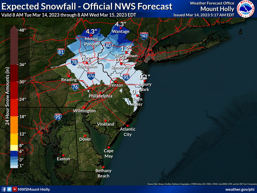
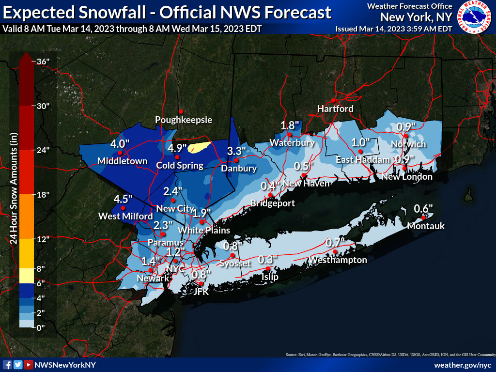
Well, looking like a pretty big bust for all those northern areas in NEPA/NJ and parts of SENY that were under warnings (Poconos, Warren-Sussex-Morris-Passaic and Orange-Putnam) and were forecast to be getting 6-12" (with up to 18" in the higher elevations) just 24 hours ago, as these areas are now generally forecast to get 2-8" (with most at 2-4" and up to 8" at the higher elevations)as per the updated NWS maps below. And the next tier of counties to the south of there that were forecast to get 3-6" of snow, like Bergen-Rockland-Westchester, look like they probably won't get more than 2-3" of snow as per the updated maps.
For most of the rest of us, who were only forecast to get an inch to maybe 2" of snow after a lot of rain, even the rain part of the forecast busted low, with generally 0.5-1.0" of rain vs. the 1-2" of rain forecast. The snow part still could verify for parts of CNJ, NENJ, NYC/LI, but might not, also, as much of the snow that will fall today will likely melt, unless there are some heavier bands that will allow the snow to overcome temps in the mid-30s in the indirect mid-March solar insolation. Having said that, despite not expecting any snow accumulations on roads, some heavier bands at times could lead to visibility issues. There are wind advisories up for gusts to 50 mph for all of SEPA/SNJ and the Jersey Shore up to Monmouth and for LI (but not yet for CNJ/NNJ/NYC). Coastal flood advisories are only up for LI.
For those curious about what “went wrong,” essentially, with the main low heading further east than thought, to the east of Cape Cod and stalling off the coast of Maine (with a secondary low near LI), most of the precip ended up staying east of the Hudson River, decreasing snow and rain amounts significantly. Today’s precip is only because of bands rotating pretty far SW of the low near Maine (enhanced by the second low or double-barreled low), but we’re so far away from the main precip source that the snow amounts will be fairly minor.
This was likely our last hope for snow...although to quote Yoda, there is another (3/21-22 - only 7-8 days away - what could go wrong?).
https://www.weather.gov/phi/
Last edited:

Good thing they delayed the school openings so they could drive in the snow. At 7am nothing!Its snowing in Belle Mead
DON'T you'll jinx this no snow winter. Leave them until May.Driveway markers are coming down today. It’s over Johnny
Another unexpected bout of snow here in northwestern NC overnight/this morning. While "snow showers" were a possibility, we pretty much got a storm. 5" so far; drifts of 12"+. NW winds 20-30 mph with gusts to 50. High temp in town (Boone) today 32 with low of 17, subtract 5-7 for up here. "Snow showers" continuing til noon then gradual clearing. Yeehaaawww....
Similar threads
- Replies
- 608
- Views
- 17K
- Replies
- 62
- Views
- 2K
- Replies
- 771
- Views
- 20K
ADVERTISEMENT
ADVERTISEMENT