First pattern thread of this winter. Let's see how it goes - maybe even have some fun with it or perhaps even learn something - I always do reading what some of the top mets have to say. Keep in mind that the further we go out in time, the less accurate even pattern forecasts are, meaning the coming warm-up is virtually a lock, while the subsequent pattern flip to cold and possibly snowy in about 2 weeks is fairly likely with regard to colder temps, but confidence in a snowier than normal period is a fair amount less certain.
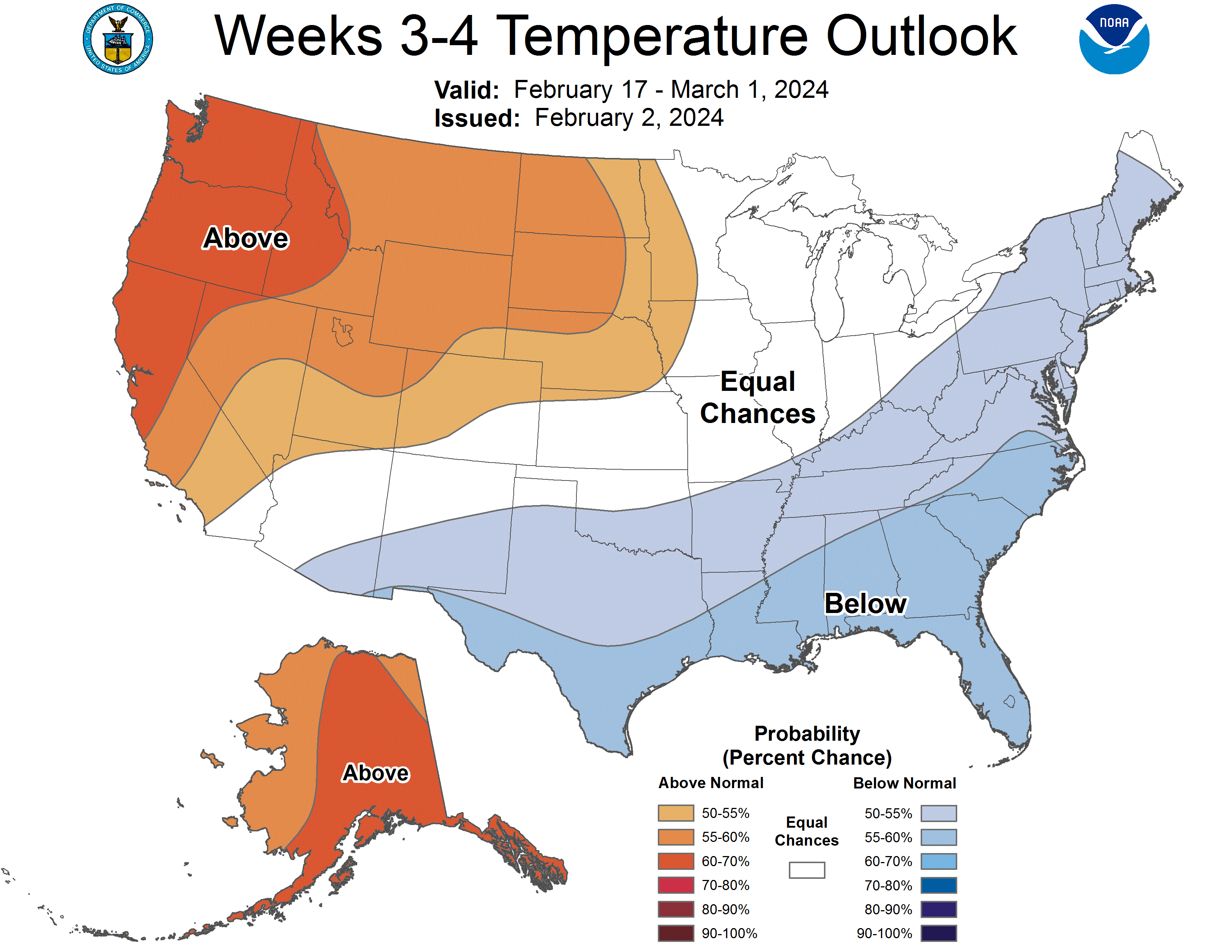
To be clear, I'm not ready to pull the trigger on predicting a colder and/or snowier than normal 2/14-2/28, yet, since 2-4 weeks out is still hard to forecast well, but I will say this is the best consensus we've seen on such a pattern 2+ weeks out this winter and it has many professional mets honking for a return to winter, including John Homenuk (Earthlight of message board fame), who is a pretty skeptical met usually (see his tweets below). If we still see consensus for a pattern change starting around 2/14 3-4 days from now, I'll be all in predicting a colder/snowier 2nd half of Feb (I've always felt more comfortable being within 10 days of the start of a pattern change). However, if the modeled pattern change fizzles and doesn't deliver meaningful snow for the region, we're likely looking at another sub-10" winter, at least for NYC and that would be the first time NYC has ever seen back-to-back winters with <10" of snow.
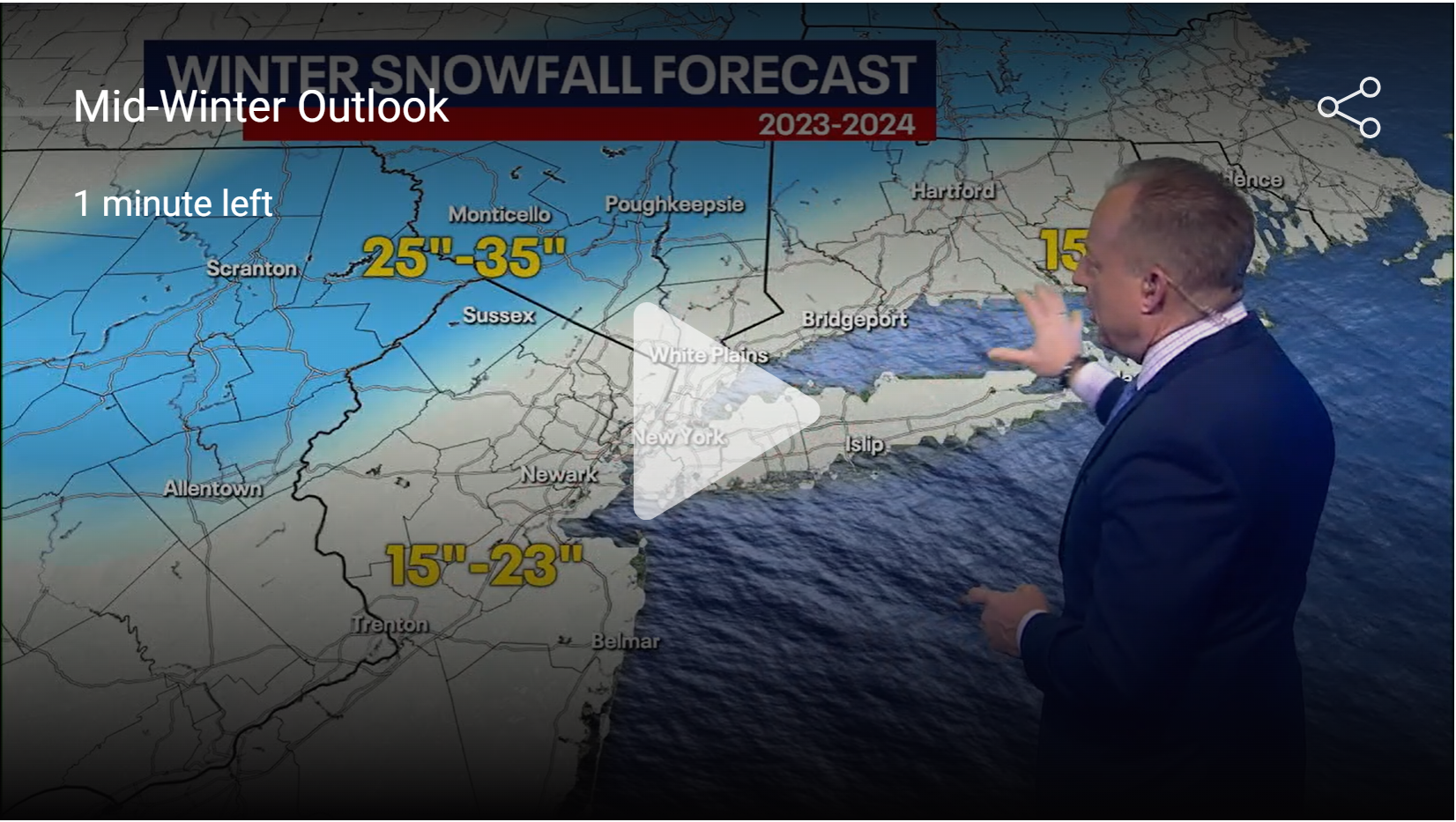
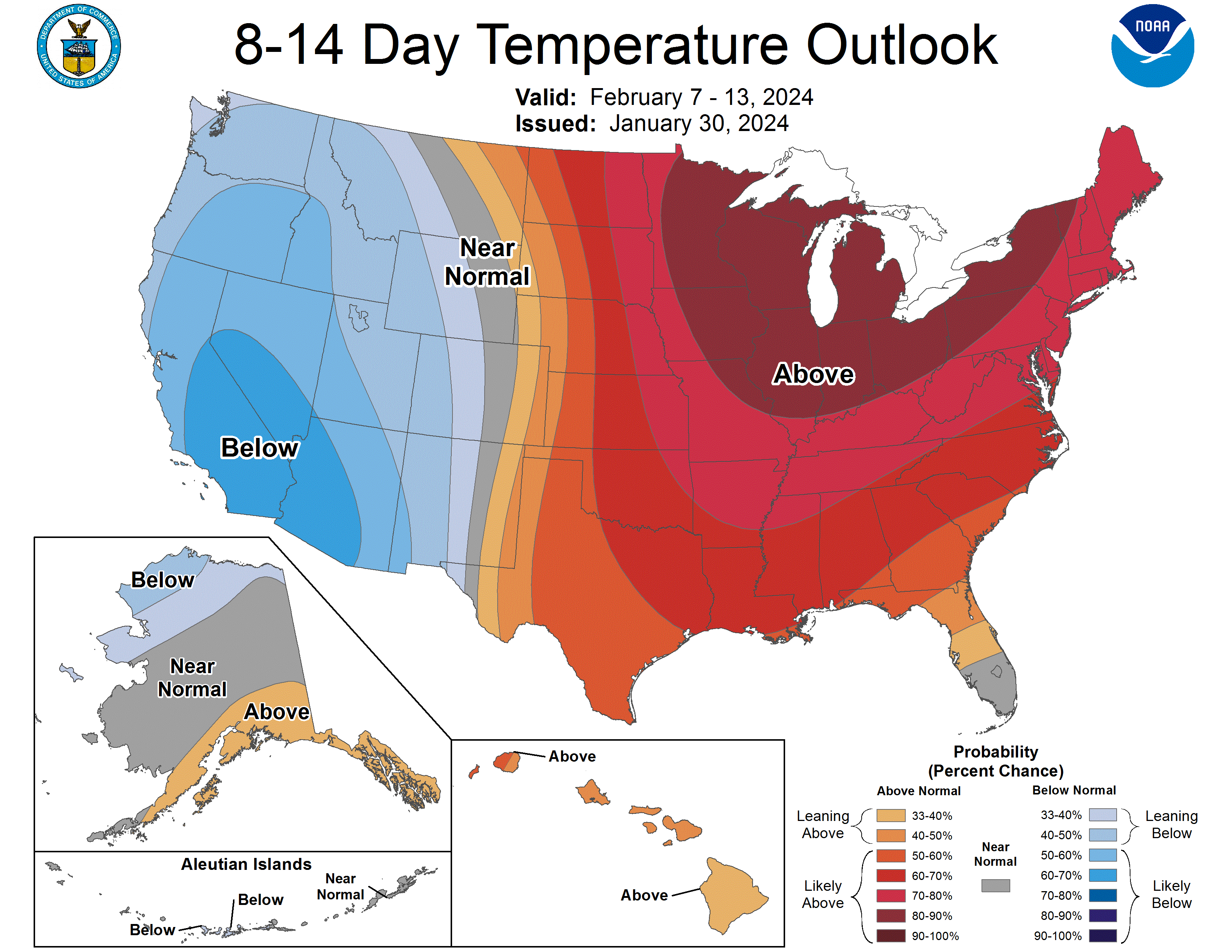
So, the average temp pattern we've been in for about the past week is expected to warm up somewhat later this week and then should warm up considerably from about 2/7 through 2/13, as per the CPC graphic below, which gives us a 70-80% likelihood of having above normal temps (normal, right now is about 41/22F in NB, rising to about 42/24F by 2/15 and to 46/27F by 3/1) from 2/7 through 2/13. Above and below normal temps aren't that difficult to forecast well for days 8-14, but snowfall/precip are much harder to forecast, but having said that it looks pretty solid that we're not going to see anything more than nuisance snow (i.e., below normal snow) from now through about 2/13. The average Feb snowfall in NB, a good location to evaluate, as it has a good data record, is 8.2". The current and near future pattern features a typical El Nino setup with a trough out west and a ridge in the eastern half of the country, leading to our area getting flow of air from the Pacific through the western US, which is usually warmer than normal for us, as the subtropical jet stream (the PacJet as it's often called) stays to our north, meaning we're not getting any cold flow from Canada from the polar jet stream.
However, every long term ensemble model (ensembles, where each model is run with 20-50 variations in initial conditions, to gauge parameter sensitivity are the primary tools for evaluating medium/long-range trends - they don't predict what will happen on specific days, which is impossible 2+ weeks out) forecast from the Euro, GFS, and CMC are showing a fairly rapid flip of the pattern to one where there is a persistent low/trough near the Aleutians, then a persistent ridge in the PacNW with the PacJet flowing clockwise around that high and diving down into the south and then heading up towards Greenland with a persistent trough in the eastern US, allowing colder air to penetrate to our area and opening up the possibility for storms to traverse near that jet and coming up the coast, potentially delivering winter weather. This pattern looks to remain in place from about 2/14 through the end of February and maybe into early/mid-March. It doesn't mean every day would be colderthan normal, but most would be and there's no guarantee of snow, but this kind of pattern is similar to what we've seen in other El Nino snowy February's, like 2010 (Feb is often the snowiest month during an El Nino, which features warm equatorial Pacific ocean temps). Also, given that this pattern flip is still almost 2 weeks away, it's possible the long range ensembles are wrong (it's happened before and it'll happen again, but they're right much more than wrong for patterns 2-4 weeks out).
Also, it's worth noting that the three outcomes for temp and snowfall predictions are simply below normal, normal and above normal, so just by guessing one would have a 1/3 probability of guessing right. I don't have these data at my fingertips right now, but what I've done in the past is looked at the top third, middle third and bottom third of past periods' temps and snowfall and how the period in question stacks up vs those categories (it'll be a bit more complicated for the first half and 2nd half of Feb as the avg temps are increasing, while the avg snowfall is decreasing through the month).
https://www.americanwx.com/bb/topic/59981-february-2024/page/12/
To be clear, I'm not ready to pull the trigger on predicting a colder and/or snowier than normal 2/14-2/28, yet, since 2-4 weeks out is still hard to forecast well, but I will say this is the best consensus we've seen on such a pattern 2+ weeks out this winter and it has many professional mets honking for a return to winter, including John Homenuk (Earthlight of message board fame), who is a pretty skeptical met usually (see his tweets below). If we still see consensus for a pattern change starting around 2/14 3-4 days from now, I'll be all in predicting a colder/snowier 2nd half of Feb (I've always felt more comfortable being within 10 days of the start of a pattern change). However, if the modeled pattern change fizzles and doesn't deliver meaningful snow for the region, we're likely looking at another sub-10" winter, at least for NYC and that would be the first time NYC has ever seen back-to-back winters with <10" of snow.
So, the average temp pattern we've been in for about the past week is expected to warm up somewhat later this week and then should warm up considerably from about 2/7 through 2/13, as per the CPC graphic below, which gives us a 70-80% likelihood of having above normal temps (normal, right now is about 41/22F in NB, rising to about 42/24F by 2/15 and to 46/27F by 3/1) from 2/7 through 2/13. Above and below normal temps aren't that difficult to forecast well for days 8-14, but snowfall/precip are much harder to forecast, but having said that it looks pretty solid that we're not going to see anything more than nuisance snow (i.e., below normal snow) from now through about 2/13. The average Feb snowfall in NB, a good location to evaluate, as it has a good data record, is 8.2". The current and near future pattern features a typical El Nino setup with a trough out west and a ridge in the eastern half of the country, leading to our area getting flow of air from the Pacific through the western US, which is usually warmer than normal for us, as the subtropical jet stream (the PacJet as it's often called) stays to our north, meaning we're not getting any cold flow from Canada from the polar jet stream.
However, every long term ensemble model (ensembles, where each model is run with 20-50 variations in initial conditions, to gauge parameter sensitivity are the primary tools for evaluating medium/long-range trends - they don't predict what will happen on specific days, which is impossible 2+ weeks out) forecast from the Euro, GFS, and CMC are showing a fairly rapid flip of the pattern to one where there is a persistent low/trough near the Aleutians, then a persistent ridge in the PacNW with the PacJet flowing clockwise around that high and diving down into the south and then heading up towards Greenland with a persistent trough in the eastern US, allowing colder air to penetrate to our area and opening up the possibility for storms to traverse near that jet and coming up the coast, potentially delivering winter weather. This pattern looks to remain in place from about 2/14 through the end of February and maybe into early/mid-March. It doesn't mean every day would be colderthan normal, but most would be and there's no guarantee of snow, but this kind of pattern is similar to what we've seen in other El Nino snowy February's, like 2010 (Feb is often the snowiest month during an El Nino, which features warm equatorial Pacific ocean temps). Also, given that this pattern flip is still almost 2 weeks away, it's possible the long range ensembles are wrong (it's happened before and it'll happen again, but they're right much more than wrong for patterns 2-4 weeks out).
Also, it's worth noting that the three outcomes for temp and snowfall predictions are simply below normal, normal and above normal, so just by guessing one would have a 1/3 probability of guessing right. I don't have these data at my fingertips right now, but what I've done in the past is looked at the top third, middle third and bottom third of past periods' temps and snowfall and how the period in question stacks up vs those categories (it'll be a bit more complicated for the first half and 2nd half of Feb as the avg temps are increasing, while the avg snowfall is decreasing through the month).
https://www.americanwx.com/bb/topic/59981-february-2024/page/12/