

Colleges
- American Athletic
- Atlantic Coast
- Big 12
- Big East
- Big Ten
- Colonial
- Conference USA
- Independents (FBS)
- Junior College
- Mountain West
- Northeast
- Pac-12
- Patriot League
- Pioneer League
- Southeastern
- Sun Belt
- Army
- Charlotte
- East Carolina
- Florida Atlantic
- Memphis
- Navy
- North Texas
- Rice
- South Florida
- Temple
- Tulane
- Tulsa
- UAB
- UTSA
- Boston College
- California
- Clemson
- Duke
- Florida State
- Georgia Tech
- Louisville
- Miami (FL)
- North Carolina
- North Carolina State
- Pittsburgh
- Southern Methodist
- Stanford
- Syracuse
- Virginia
- Virginia Tech
- Wake Forest
- Arizona
- Arizona State
- Baylor
- Brigham Young
- Cincinnati
- Colorado
- Houston
- Iowa State
- Kansas
- Kansas State
- Oklahoma State
- TCU
- Texas Tech
- UCF
- Utah
- West Virginia
- Illinois
- Indiana
- Iowa
- Maryland
- Michigan
- Michigan State
- Minnesota
- Nebraska
- Northwestern
- Ohio State
- Oregon
- Penn State
- Purdue
- Rutgers
- UCLA
- USC
- Washington
- Wisconsin
High School
- Illinois HS Sports
- Indiana HS Sports
- Iowa HS Sports
- Kansas HS Sports
- Michigan HS Sports
- Minnesota HS Sports
- Missouri HS Sports
- Nebraska HS Sports
- Oklahoma HS Sports
- Texas HS Hoops
- Texas HS Sports
- Wisconsin HS Sports
- Cincinnati HS Sports
- Delaware
- Maryland HS Sports
- New Jersey HS Hoops
- New Jersey HS Sports
- NYC HS Hoops
- Ohio HS Sports
- Pennsylvania HS Sports
- Virginia HS Sports
- West Virginia HS Sports
ADVERTISEMENT
Install the app
How to install the app on iOS
Follow along with the video below to see how to install our site as a web app on your home screen.
Note: This feature may not be available in some browsers.
You are using an out of date browser. It may not display this or other websites correctly.
You should upgrade or use an alternative browser.
You should upgrade or use an alternative browser.
OT: Will be warm (little/no snow) thru ~2/13, then a possible colder and snowier pattern
- Thread starter RU848789
- Start date
Are you even capable of reading what I post or engaging in an actual rational conversation? I'm actually serious. You make yourself look like an idiot when you claim I said things I didn't say. I'm predicting zero snow for the first half of Feb and above normal for the 2nd half. Feel free to argue with what I'm predicting, as there are plenty of meteorological reasons why the long range models could be wrong, meaning my predictions will be wrong, but maybe stop with the ignorant crap. As much as you're trying to be T, you're not T. I actually believe you're better than that and have opinions worth sharing, but your last few posts don't reflect that.Do you realize anyone can predict snow in February and be right
Cannot wait for your victory lap
Are you even capable of reading what I post or engaging in an actual rational conversation? I'm actually serious. You make yourself look like an idiot when you claim I said things I didn't say. I'm predicting zero snow for the first half of Feb and above normal for the 2nd half. Feel free to argue with what I'm predicting, as there are plenty of meteorological reasons why the long range models could be wrong, meaning my predictions will be wrong, but maybe stop with the ignorant crap. As much as you're trying to be T, you're not T. I actually believe you're better than that and have opinions worth sharing, but your last few posts don't reflect that.
This isnt a weather board or your board. Im just scratching my head at the worth of a pattern change thread started 18 days before the pattern change may begin. Weather changes. News at 11

You are correct that it's not a weather board or my board and that there may be little worth to a pattern thread started 14 days before the change begins (not 18). However, you also don't have to post in it if you think it's a meaningless thread, especially given that 90% of the OT threads are fairly meaningless in the big picture and 100% are meaningless in the context of a sports board, but then again, we all know this is largely an OT board masquerading as a sports board, so it seems a little hypocritical to only be so dismissive of this one thread and not all the rest on the board.This isnt a weather board or your board. Im just scratching my head at the worth of a pattern change thread started 18 days before the pattern change may begin. Weather changes. News at 11
Maybe he's trying to say you cover your ass. You make a prediction that it will get cold in 10 days but if it doesn't it's ok because there could be many meteorological reasons why it won't happen.
Colder than normal for NB would be about 2F below normal and normal highs are 42F on 2/14 and 46F on 3/1 in NB, so about 2F less than that would be below normal, i.e., in the bottom 1/3 of outcomes vs. NB's 130 year record of weather. Roughly speaking.
So victory laps if its 2 degrees below normal...wow. so highs/lows of 42/24 would qualify
Wow
To summarize the reason for this thread by the OP:So victory laps if its 2 degrees below normal...wow. so highs/lows of 42/24 would qualify
Wow

I thought this was going to be about temps in the 20s and mid 30s tops. Now its about low 40s in February
He’s not on these boards to talk about sports. Have you ever seen him post about RU sports? He’s here to troll.It’s a mission for him. He went after poor Adele Springsteen too. Is nothing sacred? I know the answer. 😂
Global warming is awesome! Love these mild NJ winters.I thought this was going to be about temps in the 20s and mid 30s tops. Now its about low 40s in February
Are you even capable of reading what I post or engaging in an actual rational conversation? I'm actually serious. You make yourself look like an idiot when you claim I said things I didn't say. I'm predicting zero snow for the first half of Feb and above normal for the 2nd half. Feel free to argue with what I'm predicting, as there are plenty of meteorological reasons why the long range models could be wrong, meaning my predictions will be wrong, but maybe stop with the ignorant crap. As much as you're trying to be T, you're not T. I actually believe you're better than that and have opinions worth sharing, but your last few posts don't reflect that.
LOL. I remember being told any forecasts longer than a few days in the future is worthless.
Global warming is awesome! Love these mild NJ winters.
And the increased growing season and fertile land areas are great for lowering the price of food.
Last edited:
So victory laps if its 2 degrees below normal...wow. so highs/lows of 42/24 would qualify
Wow
Remember, he's a chemist and a better meteorologist than the professionals.
There's a difference between discussing what could go wrong with a forecast (many things) and not taking responsibility if that forecast is wrong. Every time I've done one of these threads that was wrong, I detailed the data and acknowledged that the temp or snowfall prediction was wrong. If this one's wrong, I'll be the first to acknowledge it. Why wouldn't I?Maybe he's trying to say you cover your ass. You make a prediction that it will get cold in 10 days but if it doesn't it's ok because there could be many meteorological reasons why it won't happen.
Some forecasts are right, some are wrong - it's not a big deal to be wrong, especially in the science world. I ran experiments (or oversaw the work of others) that "failed" occasionally, but that was ok, as failures often led to key learnings pointing the way to additional work, although sometimes a failed experiment was simply a dead end. One gets used to it.
And once again, you don't read very closely. Forecasts for the specific weather for a specific day are mostly useless beyond 7-8 days and completely useless beyond about 10 days. However, forecasts for key trends like temp and precip over a certain period of time, like a 2 week window starting 2 weeks from now, are not useless at all and have some decent skill. Obviously, that skill is better 2 weeks out vs. 4 weeks out and at some point pattern forecasts become useless.LOL. I remember being told any forecasts longer than a few days in the future is worthless.
Really? It was still pretty crisp today. I think we beat 40 in Somerset County.So this 40 degree weather still hasn't materialized here, I don't think we've topped 40° yet. Certainly not today.
So wait, are you telling me that the approach every meteorologist uses to define normal, above normal and below normal temps (or any other variable) is no longer ok, i.e., splitting all of the February's into the top 1/3 of average temps (above normal), the middle 1/3 of avg temps (normal) and the bottom 1/3 of avg temps (below normal)? Perhaps you should propose some other system to the American Meteorological Society.So victory laps if its 2 degrees below normal...wow. so highs/lows of 42/24 would qualify
Wow
If we were doing the whole month of Feb, 1/3 of months were 39.0F or less, 1/3 were 39.0-43.1F, and 1/3 were above 43.2F, with the mean being 40.9F, so clearly Feb's just 2F below the mean are colder than normal and Feb's just 2.2F above the mean are warmer than normal. I don't make shit up.
https://climate.rutgers.edu/stateclim_v1/monthlydata/index.php?stn=286055&elem=maxt
Really? It was still pretty crisp today. I think we beat 40 in Somerset County.
It hit 37° here today, it's now down below freezing again.
Was a gorgeous 45F day without a cloud in the sky in Manahawkin - I even got a little sunburn, lol...So this 40 degree weather still hasn't materialized here, I don't think we've topped 40° yet. Certainly not today.
I think just running around got u winded and red.Was a gorgeous 45F day without a cloud in the sky in Manahawkin - I even got a little sunburn, lol...
So wait, are you telling me that the approach every meteorologist uses to define normal, above normal and below normal temps (or any other variable) is no longer ok, i.e., splitting all of the February's into the top 1/3 of average temps (above normal), the middle 1/3 of avg temps (normal) and the bottom 1/3 of avg temps (below normal)? Perhaps you should propose some other system to the American Meteorological Society.
If we were doing the whole month of Feb, 1/3 of months were 39.0F or less, 1/3 were 39.0-43.1F, and 1/3 were above 43.2F, with the mean being 40.9F, so clearly Feb's just 2F below the mean are colder than normal and Feb's just 2.2F above the mean are warmer than normal. I don't make shit up.
https://climate.rutgers.edu/stateclim_v1/monthlydata/index.php?stn=286055&elem=maxt
Its not hard to make a prediction..50/50 shot at being right
No one notices 2 degrees below normal in February
No, it's a 1 in 3 shot at being right, for both temp and snow. Might want to stick to hoops if you can't follow the simplest of concepts.Its not hard to make a prediction..50/50 shot at being right
No one notices 2 degrees below normal in February
No, it's a 1 in 3 shot at being right, for both temp and snow. Might want to stick to hoops if you can't follow the simplest of concepts.
See @bac2therac , no one's ever as smart as Captain Chaos.
While we're having gorgeous weather, California is getting absolutely hammered with heavy rains, with major flooding and mudslides likely, as well of feet of snow in the mountains, plus there's actually a hurricane force wind warning just off the Bay Area coast and high wind warnings inland nearly everywhere in the entire state. Could also be flash floods in the deserts of CA/NV/AZ.
2 days ago the forecast was for my friend to be driving down 95 in rain tomorrow to meet me in NC. Today it says 48 and bright sun.LOL. I remember being told any forecasts longer than a few days in the future is worthless.
Yup, had to look up what an “atmospheric river” was last week. Interesting to see the panic when an inch is rain is forecast.While we're having gorgeous weather, California is getting absolutely hammered with heavy rains, with major flooding and mudslides likely, as well of feet of snow in the mountains, plus there's actually a hurricane force wind warning just off the Bay Area coast and high wind warnings inland nearly everywhere in the entire state. Could also be flash floods in the deserts of CA/NV/AZ.
Played soccer this morning and it was a chilly 28F to start at 8 am, but was nearly 40F by 10 am and we actually went for our usual after game coffee downtown and sat outside, since it was in the low 40s by then with light winds and sunshine. Gorgeous. About to do a little day trip somewhere with the better half so we can get out and about in this weather.We are steamin' here at 36° right now. Damn, I gotta turn on the air conditioning!
It's funny how a little rain gets to folks in Cali, but this is way beyond a little rain, with 3-5" or more likely today for most of the coast and inland with up to 5' of snow possible in the high Sierras - going to make for some great skiing (but some avalanche risk too).Yup, had to look up what an “atmospheric river” was last week. Interesting to see the panic when an inch is rain is forecast.
2 days ago the forecast was for my friend to be driving down 95 in rain tomorrow to meet me in NC. Today it says 48 and bright sun.
Yeah but that was just a professional meteorologist. The guy here has assured us he's better.
Normal rainfall in Los Angeles is about 12-14 inches a year (compared to 46 inches in NYC), and much of the city is on or near unstable hillsides. Were it not for importing water from elsewhere (as in the movie Chinatown), L.A. could not be a major city.It's funny how a little rain gets to folks in Cali, but this is way beyond a little rain, with 3-5" or more likely today for most of the coast and inland with up to 5' of snow possible in the high Sierras - going to make for some great skiing (but some avalanche risk too).
Hopefully nobody here takes a rodent's forecasts seriously and this year it's looking very likely the little varmint will be wrong again. Every medium/long-term ensemble model forecast continues to show a major pattern shift starting around 2/13-14 (which is now only 11-12 days away), ushering in colder than normal temps while still having a decent number of storms, which likely equates to a snowier than normal period from about 2/13-14 through the end of Feb (once we get past the warm/snowless first 2 weeks of Feb, which are now a lock) and possibly through mid-March. Given the consistency of the models on this and the decent number of well-respected pros (see below) who are on board with the pattern change, I'm jumping on that bandwagon too and am going out on a limb and calling for colder and snowier than normal conditions from 2/13 through 2/28.
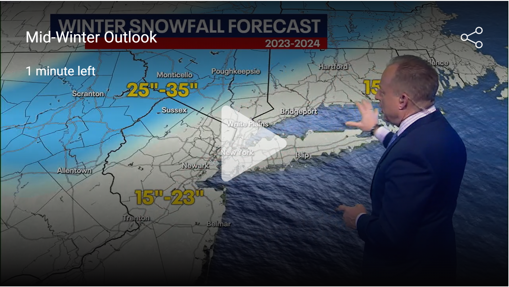
Nick Gregory is the latest met to be on board with this and he's one of the 2-3 best in NYC, IMO. He's generally pretty conservative, but he's calling for a pretty good chance of another ~15" or so of snow for NYC (which means the 95 corridor from at least Trenton to SE CT, really) this winter as per his graphic below, which shows 15-23" of snow for the whole winter for the 95 corridor and the coast (and 25-35" a bit NW of 95). The snow would come after about mid-February, which is when the pattern shift is expected and 15" from mid-Feb through the end of winter would be well above normal (which is about 9-10" during that time).
And if you want to see the nitty gritty details of what, exactly, the models are showing with regard to this pattern change, DT's/WxRisk's video, below does a nice job of that (starting around 8 minutes in), i.e., by mid-Feb, the MJO (Madden-Julian Oscillation) is forecast to be going into phases 8 and 1, the AO (Arctic Oscillation) and NAO (North Atlantic Oscillation) heading negative on the Atlantic side of North America, and the PNA (Pacific/North America pattern) heads positive and the EPO (Eastern Pacific Oscillation) heads negative. Every one of those teleconnections is favorable for eastern US cold and possibly snow in winter.
There are also snowfall maps starting to circulate on social media showing ridiculous amounts of snow for the NE US and our area (like 20-30") from mid-Feb through mid-March. They're fun to look at but a bit silly to forecast this far out. In fact, we've had somewhat similar patterns to what we're expecting to have soon without getting much snow (sometimes too much cold air suppresses storms and sometimes timing just never lines up right for major snowstorms), but these patterns do produce snow for our area much more often than most other patterns and have been responsible for some of our snowiest periods ever, like Feb 2010
https://www.americanwx.com/bb/topic...n-part-of-the-nyc-subforum-event-obs/page/46/
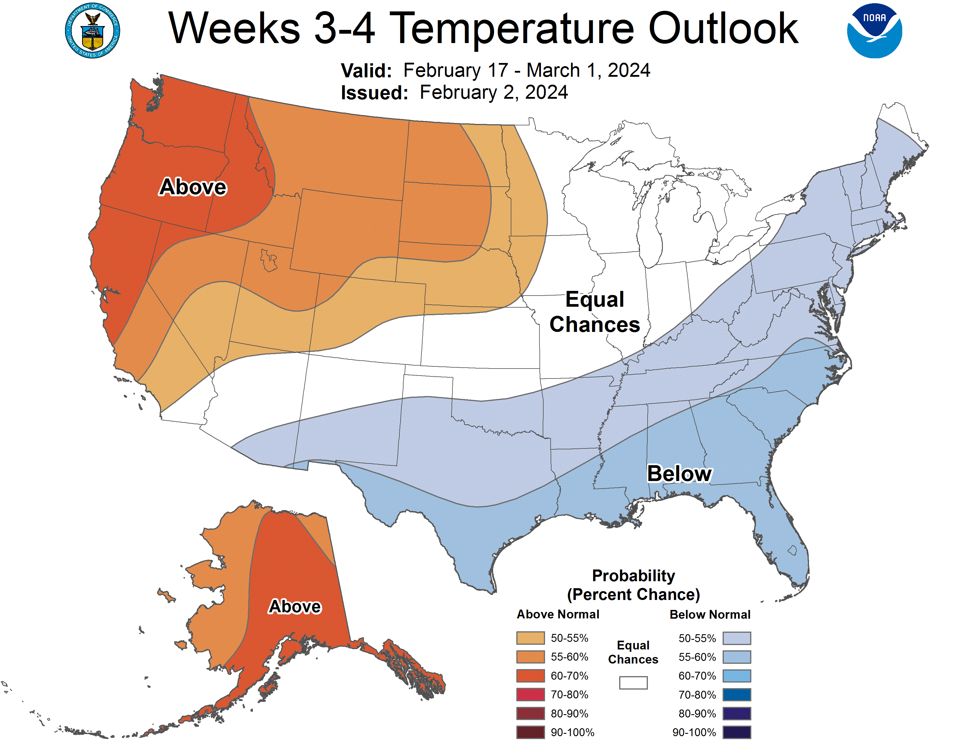
Finally, NOAA's CPC (Climate Prediction Center) has partially bought in to this major pattern change but not completely, as the graphics only have the SE US being colder than normal, while the mid-Atlantic and NE US have average temps (and slightly drier than normal conditions) for the 2/17-3/1 period. However, the actual discussion from the CPC mentions a couple of times that colder/wetter is a distinct possibility for the NE US during this time.
https://www.cpc.ncep.noaa.gov/products/predictions/WK34/
We're now 2 days further along and all indications from the Euro/GFS/CMC ensemble model forecasts is that the pattern change being discussed is a go, probably starting a day or two earlier, i.e., by 2/13 (and maybe even 2/12), although the pattern likely won't be fully entrenched until about 2/15 and the coldest weather likely doesn't arrive until maybe 2/17 or so (and way too far out to predict any winter storms, although the period from about 2/18-2/27 does look to have greater snow chances than before 2/18). The operational models are also starting to show the pattern shift starting around 2/13 (with a chance of some wintry weather around then), which is now within ~9 days, which is no longer the fantasy land it was when I started the thread about 5 days ago.
As mentioned in the first post, the pattern generally features a persistent low/trough near the Aleutians, then a persistent ridge in the PacNW with the PacJet (subtropical jet stream) flowing clockwise around that high and diving down into the southwest (perhaps with some "split flow") and then heading up towards Greenland with a persistent trough in the eastern US and featuring high latitude "blocking" near Greenland (a negative NAO), allowing colder air to penetrate to our area and opening up the possibility for storms to traverse near that jet and coming up the coast, potentially delivering winter weather, which is why I'm predicting (educated guess really) from about 2/13 through the end of Feb to be colder and snowier than normal.
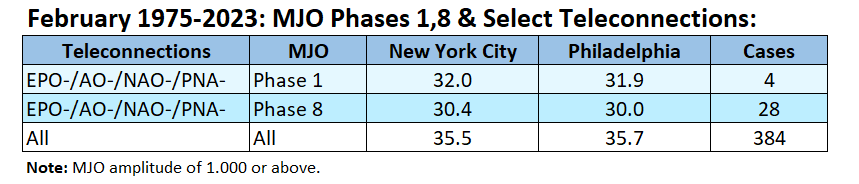
Since there isn't a lot of published data on what these patterns, as indicated by key MJO/teleconnections in the quoted thread above, actually mean for our area, I asked DonSutherland, the king of meteorological data on the weather boards (and maybe anywhere) to see if he could find data on what these patterns mean and he was able to find the data in the table below for average temperatures in February in Philly and NYC for patterns like we expect to have soon, i.e., EPO-/AO-/NAO-/PNA+ (he has a typo below on PNA) with both phase 1 and phase 8 of the critical MJO, as well as the base case of the overall mean temp. Clearly, for both cities, we can see departures of 3-5F below the historical overall mean, which certainly is "colder than normal" (colder than normal is typically at least 2F below the mean). Colder than normal does not mean extended brutal cold either, just, you know, below normal.
Unfortunately, Don wasn't able to find similarly robust data for snowfall for this kind of pattern in Feb, but he and just about every met I've seen say that such patterns typically do lead to snowier than normal outcomes, but definitely not in all cases; see the tweet below from John Homenuk (a very influential met) discussing how this kind of pattern has "delivered significant winter storms in the past." He and others have also said the heart of the colder (and potentially snowy) pattern is likely to be from 2/17 onwards. Also, as I've mentioned before, I've tracked about 8 fairly similar patterns since 2016 and saw that all 8 verified for colder than normal temps and 5 verified for snowier than normal outcomes (one would expect random guessing to verify 2-3 out of 8) for the 2-3 week periods I was following (did this for New Brunswick and vs. above/normal/below for those two parameters vs. all seasons for the period in question), but that's a fairly small sample size and I didn't rigorously track the teleconnections beyond what was forecast about 8-10 days out, so it would be nice to see someone out there in the weather world obtaining more rigorous data.
Hopefully, this will be interesting and fun to follow over the next few weeks for those of you who don't think the entire effort is a waste of time. I would think people might be interested in a likely cold/snowy pattern for the 2nd half of Feb and maybe into the first half of March. People seem to like the tropical weather seasonal forecast threads, which do the same thing, predicting normal, below normal and above normal seasons - without even any insight on where those storms might even hit, while this likely pattern is saying the outcomes are actually for our area (Philly-NJ-NYC, generally speaking). Very active thread on this on AmericanWx - way more vitriol there than here, actually, but those posts get deleted quickly.
https://www.americanwx.com/bb/topic/59981-february-2024/page/31/#comment-7194003
Last edited:
We have two weeks of great weather (for winter) in front of us. Why be the buzzkill with this predicted pattern shift which may or may not happen? This thread was not a good idea.
Never got above 39° in my backyard. Just to be sure my digital indoor/outdoor thermometer was correct, I put out 2 more (a digital and a standard) and they matched. Now when I drove down into lower parts of Wayne it was a couple of degrees warmer, but we're still not seeing it here.
^^^^^ Weather troll!We have two weeks of great weather (for winter) in front of us. Why be the buzzkill with this predicted pattern shift which may or may not happen? This thread was not a good idea.
😁
Guilty as charged! 😁^^^^^ Weather troll!
😁
Similar threads
- Replies
- 20
- Views
- 887
- Replies
- 350
- Views
- 10K
- Replies
- 62
- Views
- 2K
ADVERTISEMENT
ADVERTISEMENT