Saw Claire last week at the deli and she had a Hillsborough Deli Mask on. Claire and the girls have been running a drive to support local bussinesses hence they’re selling the masks and eating out / taking out food from every possible local restaurant. On her Twitter she said she’s looking forward to the snowstorm so she can shed some working from home pounds. By the way, HIllsborough Deli has a buy 1 get 1 free hero when snow exceeds 6 inches.No more Hillsborough Deli updates?


Colleges
- American Athletic
- Atlantic Coast
- Big 12
- Big East
- Big Ten
- Colonial
- Conference USA
- Independents (FBS)
- Junior College
- Mountain West
- Northeast
- Pac-12
- Patriot League
- Pioneer League
- Southeastern
- Sun Belt
- Army
- Charlotte
- East Carolina
- Florida Atlantic
- Memphis
- Navy
- North Texas
- Rice
- South Florida
- Temple
- Tulane
- Tulsa
- UAB
- UTSA
- Boston College
- California
- Clemson
- Duke
- Florida State
- Georgia Tech
- Louisville
- Miami (FL)
- North Carolina
- North Carolina State
- Pittsburgh
- Southern Methodist
- Stanford
- Syracuse
- Virginia
- Virginia Tech
- Wake Forest
- Arizona
- Arizona State
- Baylor
- Brigham Young
- Cincinnati
- Colorado
- Houston
- Iowa State
- Kansas
- Kansas State
- Oklahoma State
- TCU
- Texas Tech
- UCF
- Utah
- West Virginia
- Illinois
- Indiana
- Iowa
- Maryland
- Michigan
- Michigan State
- Minnesota
- Nebraska
- Northwestern
- Ohio State
- Oregon
- Penn State
- Purdue
- Rutgers
- UCLA
- USC
- Washington
- Wisconsin
High School
- Illinois HS Sports
- Indiana HS Sports
- Iowa HS Sports
- Kansas HS Sports
- Michigan HS Sports
- Minnesota HS Sports
- Missouri HS Sports
- Nebraska HS Sports
- Oklahoma HS Sports
- Texas HS Hoops
- Texas HS Sports
- Wisconsin HS Sports
- Cincinnati HS Sports
- Delaware
- Maryland HS Sports
- New Jersey HS Hoops
- New Jersey HS Sports
- NYC HS Hoops
- Ohio HS Sports
- Pennsylvania HS Sports
- Virginia HS Sports
- West Virginia HS Sports
ADVERTISEMENT
Install the app
How to install the app on iOS
Follow along with the video below to see how to install our site as a web app on your home screen.
Note: This feature may not be available in some browsers.
You are using an out of date browser. It may not display this or other websites correctly.
You should upgrade or use an alternative browser.
You should upgrade or use an alternative browser.
OT: 12/16/20 Snowstorm Thread: First Significant Winter Storm of the Season - Major Snow/Sleet/Rain
- Thread starter RU848789
- Start date

Shop Rite gonna be packed tomorrow. To hell with social distancing. I want my friggin eggs and milk,
Ok, serious question: I've never gone out to stock up on food before a snowstorm - maybe because for the Jan 1996 storm probably the worst ever for many around here, things were only shut down for 2 days and always figured we could get by for a couple of days without stores being open. I know most folks around here are goofing around about eggs and milk, but they always show people clearing the stores before a big snowstorm. Just never quite got it...
Same. Truly bizarre behavior. I was in Costco today on errands and it was thankfully civil.
To their credit they had the most toilet paper I have ever seen in my life. Lotsa milk too.
Side note. Wife was playing soccer in Basking Ridge this morning and early afternoon. Broad daylight smash and grab. Busted passenger window and stole her purse. Why it was in there for soccer is another story. But they hit 3 cars right around noon at a nice park. Be careful out there! Hope they enjoy that big $125 they stole.
Storm will most likely continue to move N & W and from N Brunswick south will be a mix of about 2” and rain as always. I want Snow in Hamilton

Always possible, but that's not the way to bet. No model has less than a foot for NB right now. The only places with <4" are at the immediate coast south of Belmar on one of the 4 major models. Still could change, though...
Three of four of the major 12Z global models this afternoon showed a major snowstorm (8" or more) for most of the Philly-NJ-NYC region and all four of tonight's 12Z models show a major *8" or more) to historic (historic is 12-18" to me - we don't get too many of those) snowstorm on Wednesday afternoon through Thursday morning. I don't think I've ever seen this level of near model consensus 4.5 days out.
WxRisk/DT could end up being right on this one, as he's been honking on it for a few days given the great pattern, i.e., we have a -NAO (North Atlantic Oscillation Index) and a 50N/50W low to hold the cold air in place, plus what looks to be the right jet stream/trough approaching and eventual storm cyclgenesis and track along the coast; it's the last few items that have to mesh perfectly to get us major snowfall, which is why major snowfalls are fairly rare around here.
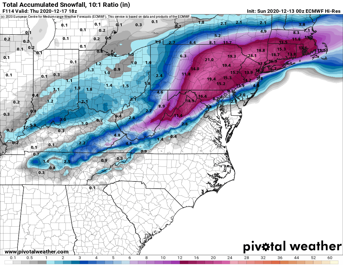
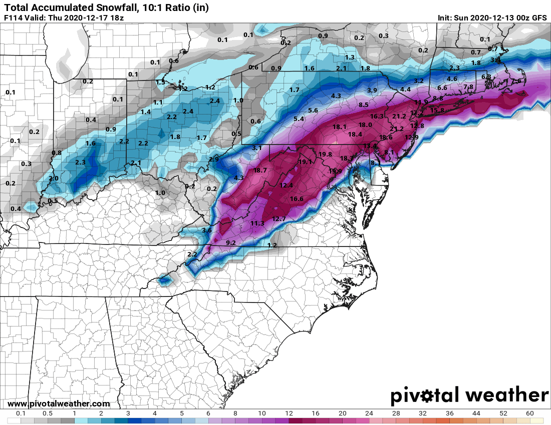
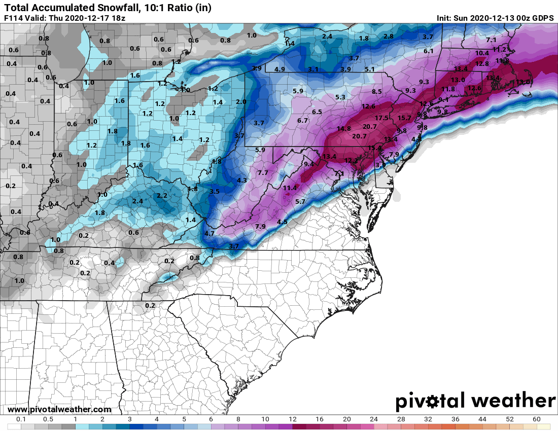
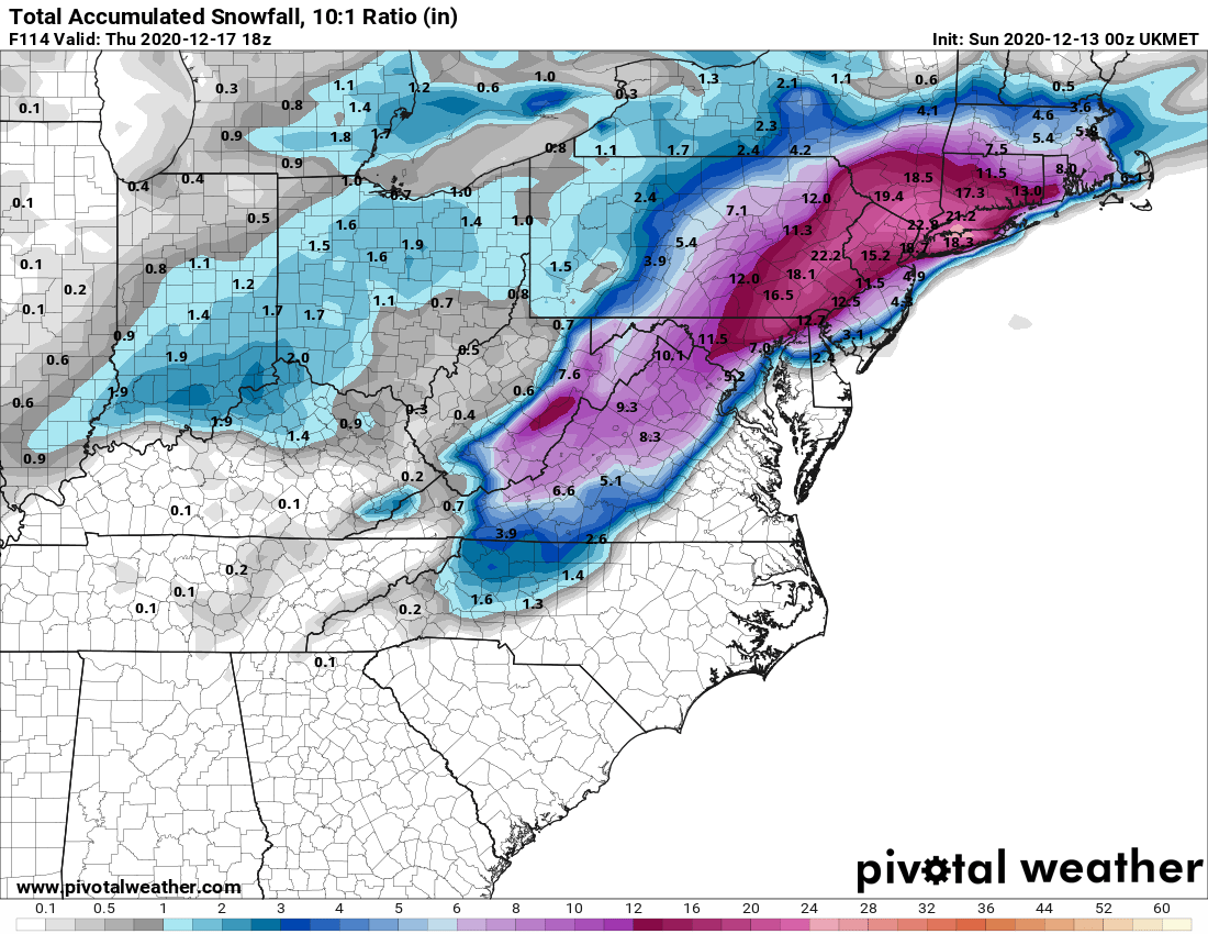
Doesn't guarantee it's going to happen, but it's starting to look like we're in for at least a moderate to significant snowfall, with the potential for much more. Of course, being this far out, numerous things can still happen to derail this, such as a further inland/warmer/wetter track or a further offshore/less precip track, but if we see anything like the track being advertised, with the cold air expected to be in place, this could be a pretty big snowstorm, even for the 95 corridor and maybe the coast (always at most risk for rain with the ocean being fairly warm this time of year). There could also be significant winds (blizzard conditions are in play) and some tidal flooding. Since this is so unusual, below are the snowfall maps for the storm.
One more point: the Euro is also showing 1-2" of snow on Monday along and just NE of 95 and 2-5" NW of 95 and especially N of 78 and the GFS is showing 1-3" or so SE of 95 and towards the coast with <1" NW of 95, while the NAM is showing a general 2-4" of snow for almost everyone (these have to be subtracted from the map below for the Weds event) and the UK/CMC are showing almost all rain and only near the coast, so oddly, much less consensus on an earlier event (but which is much more borderline with regard to having enough cold air).
https://www.weather.gov/phi/
https://www.americanwx.com/bb/topic...-17-2020/page/5/?tab=comments#comment-5725302
https://www.facebook.com/WxRisk
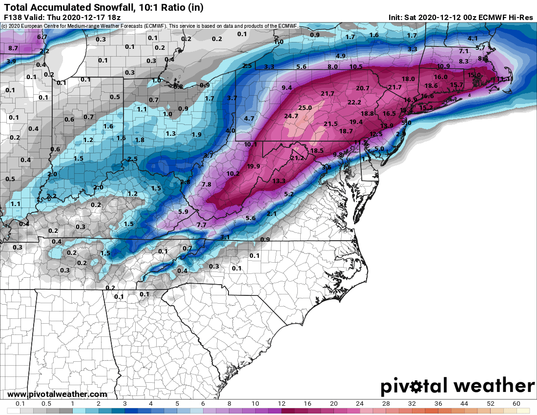
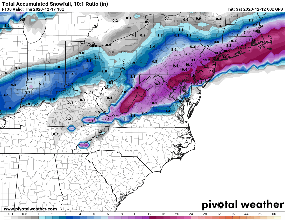
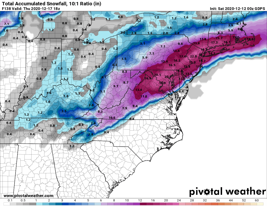
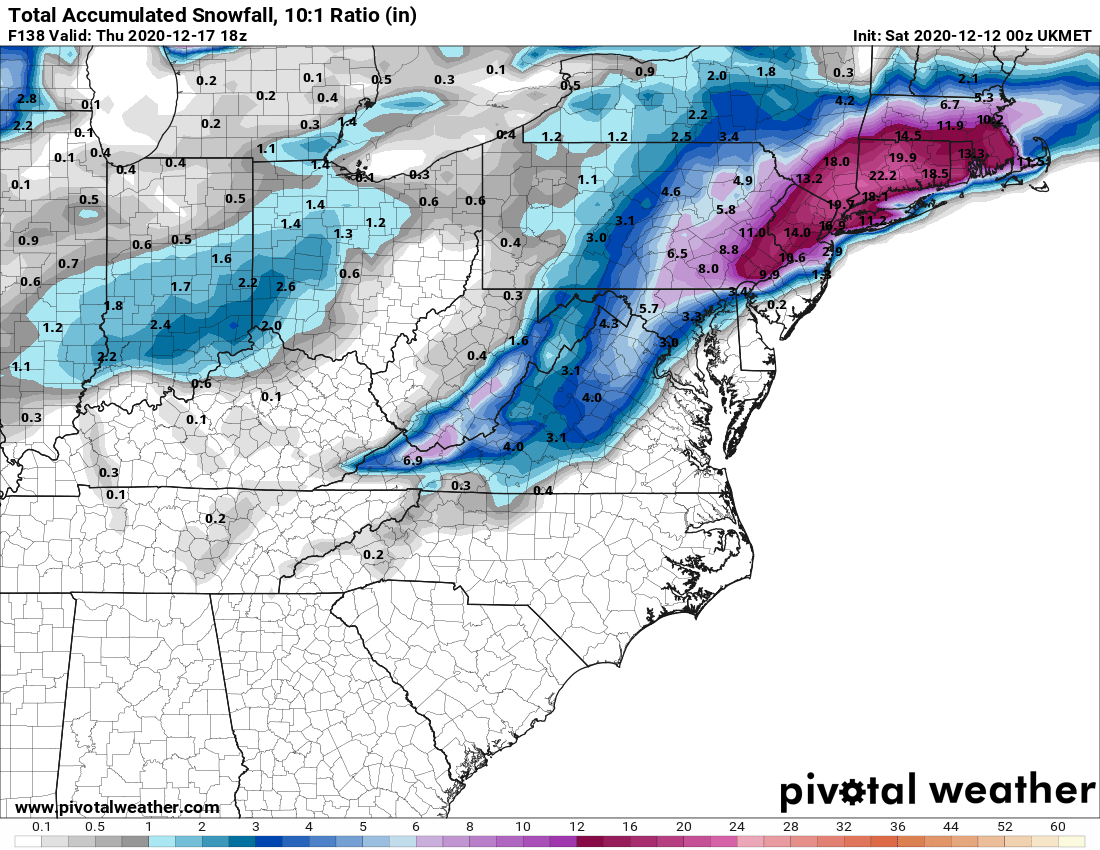
We now have 3 straight model cycles (looking at 12-hour intervals from 0Z last night to 12Z this afternoon to 0Z tonight, which just came out - data inputs were 7 pm EST) of pretty good consensus for a major to historic snowstorm on Wednesday afternoon into Thursday morning from the Euro, UK, GFS, and CMC. Everywhere from Philly to NYC, including most of NJ (only SNJ, especially near the coast looks vulnerable to a lot of rain in a couple of models), E-PA and SE-NY is modeled to get at least 8" of snow ("major") with most locations getting over 12" of snow (historic, IMO, given NYC has had 36 storms of 12" or more in 151 years or once every 4+ years - people remember storms over a foot) and some locations are modeled to get 18-24" of snow.
When I posted about this being highly unusual model consensus from 5+ days out to now on one of the weather boards, one of the very good experts there agreed and went further. He noted that the 3 major model ensembles were showing a major snowstorm from 7 days out, which he said is the first time he's seen that in a long time. Again, this is just model talk (these are models, not forecasts) and doesn't mean we're going to get a foot or more of snow everywhere, as one of the primary pieces of energy is just coming ashore in the Pac NW and hasn't been well sampled yet, so things could change. One more thing: models are showing the potential for serious wind gusts to 50-60 mph at the coast and up to 40 mph inland, so blizzard conditions are possible, as modeled (which means possible power outages) - as well as potential coastal flooding at times of high tide.
However, every met is now saying we at least now have a pretty good probability of significant snow or more. I will say this: the one huge difference for this storm over almost all of the storms last year, some of which busted badly with a lot more actual rain than predicted snow, is that we will absolutely have a strong source of cold air locked in, so a changeover to rain well inland of the coast is far less likely (but south of Toms River could get a lot of rain before any snow). The bigger "risk" to missing a big snowstorm is strong confluence leading to suppression of the storm to the SE, but no models are showing that yet. Anyway, I've always thought posting every model run is overkill, but maybe once a day (they almost all run 4X a day) is ok, so here you go...
https://www.weather.gov/phi/
https://www.33andrain.com/topic/1998-dec-16-18-possible-major-ec-snowstorm/page/57/#comments
With regard to Monday, most of the models are showing maybe 1-2" along and NW of 95 and especially N of 78, along with rain near 95 and towards the coast, so not a big deal. The NAM, however, is showing 3-6" of snow for most of the Philly-NYC area. Seems like an outlier now, but this system needs to be watched, in case more cold air filters in, as there's enough precip for a few to several inches of snow if it's cold enough.
Last edited:
This map is showing a mix from 95 east. I’m right in central Jersey (Hamilton) so I’m at that ugly cutoff point. I want the snow just as bad as u.Always possible, but that's not the way to bet. No model has less than a foot for NB right now. The only places with <4" are at the immediate coast south of Belmar on one of the 4 major models. Still could change, though...

Now I just got scared. Lost power 13 days and 4 days. If we get big winds and 2 feet of snow I don’t even want to start thinking.
I have resisted getting a generator thinking this can’t be more than a 1 in 10 year event and we can deal with it
Don't buy into the fear.
Saw Claire last week at the deli and she had a Hillsborough Deli Mask on. Claire and the girls have been running a drive to support local bussinesses hence they’re selling the masks and eating out / taking out food from every possible local restaurant. On her Twitter she said she’s looking forward to the snowstorm so she can shed some working from home pounds. By the way, HIllsborough Deli has a buy 1 get 1 free hero when snow exceeds 6 inches.
I was worried about Claire in July went she went AWOL but found out from other patrons she had a virus but not Covid-19. Those masks are great...little expensive but worth it. I like the little sayings on them beside the Hillsborough Deli logo. Our fish don't smell, thickest sausage in town, our bologna is round ready and right, we don't do 4" we do 12".
Maybe Sweet Pee can ease my concernsDon't buy into the fear.
Which park? Was it Pleasant Valley? Harry Dunham?Same. Truly bizarre behavior. I was in Costco today on errands and it was thankfully civil.
To their credit they had the most toilet paper I have ever seen in my life. Lotsa milk too.
Side note. Wife was playing soccer in Basking Ridge this morning and early afternoon. Broad daylight smash and grab. Busted passenger window and stole her purse. Why it was in there for soccer is another story. But they hit 3 cars right around noon at a nice park. Be careful out there! Hope they enjoy that big $125 they stole.
Important PSA:
Listen up, New Jersey: Don’t trust all those wild snowfall predictions flooding social media
 www.nj.com
Listen up, New Jersey: Don’t trust all those wild snowfall predictions flooding social media
Listen up, New Jersey: Don’t trust all those wild snowfall predictions flooding social media
False or misleading information about snowstorms often thrives on social media. That's why weather experts say you should be careful if you see snow forecast maps from unreliable sources.
Monday's event looks like I 78 north has the best chance for accumulating snows on roads. South of their a very wet snow where snow may only stick on grass. The NAM is the only model showing legit snows for I 95 areas so we will still have to watch to see if a heavier period of snows occur which could lead to accumulations. Its not a big event but at least should look wintry and travel could be impacted in some parts of the area
Agreed - just don't trust this modest storm to put down much accumulating snow during daylight hours (even with the very low sun angle, melting will occur) with marginal surface temps at or above 32F for the 95 corridor. But I will say the NAM has been absolutely consistent putting down a few inches for much of CNJ/NNJ - including the 12Z which just came out and has Mercer/Middlesex and all points NW of there in NJ getting 2-4" of snow - I'll believe if I see 1-2 other models showing something similar today at 12Z.Monday's event looks like I 78 north has the best chance for accumulating snows on roads. South of their a very wet snow where snow may only stick on grass. The NAM is the only model showing legit snows for I 95 areas so we will still have to watch to see if a heavier period of snows occur which could lead to accumulations. Its not a big event but at least should look wintry and travel could be impacted in some parts of the area
Great article - agree completely, which is why I usually put quite a few caveats in my posts with regard to uncertainty and these being models, not forecasts.Important PSA:
Listen up, New Jersey: Don’t trust all those wild snowfall predictions flooding social media
Listen up, New Jersey: Don’t trust all those wild snowfall predictions flooding social media
False or misleading information about snowstorms often thrives on social media. That's why weather experts say you should be careful if you see snow forecast maps from unreliable sources.
By Len Melisurgo | NJ Advance Media for NJ.com
‘Tis the season to be … wary! Yes, it’s that time of the year again, when Twitter and Facebook feeds light up with all sorts of colorful weather maps filled with big numbers and terrifying words that warn us all of impending meteorological doom.
Major snowstorm on the way! ... Blockbuster winter storm looming! ... Blizzard to blast eastern United States!
This happens every year, just as the leaves always turn colors and drop to the ground. And same as snowflakes eventually fall from our skies when the weather turns cold and moisture fills the air.
But don’t trust everything you read — especially on social media. Especially weather alerts that are posted by amateur weather enthusiasts who are not trained meteorologists. And especially predictions that are posted many days before a storm system even develops.
Many of those posts — like the ones you likely have been seeing, and perhaps sharing, during the past few days because of two potential winter storms looming next week — are based on one run of computer guidance models. Those are the special computers that spit out all sorts of weather projections about every six hours, based on current data that is fed into them.
Professional forecasters often remind the general public that computer models, even the major ones like the European model and the American GFS model (formally called the Global Forecast System) are not official forecasts. They are among the many tools used by meteorologists to analyze storm systems, weather patterns, wind direction, air temperature and other atmospheric conditions.
Computer models typically become more reliable one to three days prior to a storm. When a storm is more than several days away, models can be way off on their projections. Sometimes those early projections turn out to be spot on, but sometimes they tank.
So, if you happen to be seeing Twitter posts with computer model maps showing projections of 12 to 18 inches of snow for New Jersey and other eastern states this upcoming Wednesday into Thursday, keep in mind, that’s usually one particular model output from one particular guidance model. (There are literally dozens of computer models used by forecasters all around the world.)
Weather professionals say the general public should be skeptical over social media posts that show extreme snowfall totals or make predictions many days before a storm arrives.
“Stay with who you trust,” said Robert Deal, a meteorologist for the National Weather Service’s regional forecast office in Mount Holly, which issues forecasts for most of New Jersey, all of Delaware, most of Maryland and eastern Pennsylvania.
“That’s what we recommend,” he added. “Get the information from trusted sources,” like the National Weather Service and local television meteorologists.
“People are going to share stuff on social media, and we can understand that,” Deal added. “Any time people can find snowfall maps that suggest there could be more than a foot of snow in the Northeast corridor, you’re gonna get people talking and asking questions.”
The problem is, not everyone who is posting weather forecasts on Facebook and Twitter are actual meteorologists or trained on how to interpret complicated data coming from computer guidance models.
“Many of the maps that you currently can see artificially choose a liquid-to-snow ratio of 10 to 1,” Deal said.
With a 10-to-1 ratio, 1 inch of liquid in the atmosphere will produce about 10 inches of snow. And 2 inches of liquid will equate to about 20 inches of snow.
However, Deal noted, “that’s not always the standard.” That’s because every snowstorm is different, with varying temperatures in different layers of the atmosphere, dry air pushing in to limit the amount of moisture, and other factors, like wind direction and the speed of a storm.
Sometimes a storm is expected to move very slowly, generating higher rainfall or snowfall totals. But sometimes a storm will pick up speed and move out more quickly than initially expected, cutting down on the final totals.
What to expect next week
So, what should New Jerseyans expect for Wednesday’s storm?
Deal says the National Weather Service has growing confidence that a large coastal storm will develop and there could be “significant snowfall for portions of the forecast area.”
The big questions, however, are where, and how much snow?
For now, the weather service is not issuing specific snowfall projections in its forecast, because the storm is still more than four days away and a lot of factors can change, Deal said. For example, the exact track of the storm and the air temperatures will play a big role in how much snow falls in New Jersey and which areas may get a mix of rain and snow, or plain rain.
Could New Jersey really get slammed with 12 to 18 inches of snow next week, as some social media posts are claiming?
At this time, Deal said snow totals over a foot cannot be ruled out. But, once again, it all depends on multiple factors, like the storm path, its strength, how cold the air is at different layers of the atmosphere and — as mentioned earlier — the ratio of liquid to snow.
The bottom line: In another day or two, the National Weather Service and other professional forecasters will have a better handle on how Wednesday’s storm will play out. And they will start issuing their own forecast maps.
Maybe those maps will turn out to be as scary as some of the ones making their rounds on social media. Maybe they won’t. But at least you’ll know they came from trained meteorologists who specialize in interpreting complicated data.
A
anon_ivydyf0amkzay
Guest
It’s funny because it is true! Weather people are some of the most over reactionary folks around...”wishcasting” dominates even if data indicates otherwise. Nowadays it is even easier to...take the ONE model run that suits your wish and run with it (pun intended)Important PSA:
Listen up, New Jersey: Don’t trust all those wild snowfall predictions flooding social media
Listen up, New Jersey: Don’t trust all those wild snowfall predictions flooding social media
False or misleading information about snowstorms often thrives on social media. That's why weather experts say you should be careful if you see snow forecast maps from unreliable sources.
By Len Melisurgo | NJ Advance Media for NJ.com
‘Tis the season to be … wary! Yes, it’s that time of the year again, when Twitter and Facebook feeds light up with all sorts of colorful weather maps filled with big numbers and terrifying words that warn us all of impending meteorological doom.
Major snowstorm on the way! ... Blockbuster winter storm looming! ... Blizzard to blast eastern United States!
This happens every year, just as the leaves always turn colors and drop to the ground. And same as snowflakes eventually fall from our skies when the weather turns cold and moisture fills the air.
But don’t trust everything you read — especially on social media. Especially weather alerts that are posted by amateur weather enthusiasts who are not trained meteorologists. And especially predictions that are posted many days before a storm system even develops.
Many of those posts — like the ones you likely have been seeing, and perhaps sharing, during the past few days because of two potential winter storms looming next week — are based on one run of computer guidance models. Those are the special computers that spit out all sorts of weather projections about every six hours, based on current data that is fed into them.
Professional forecasters often remind the general public that computer models, even the major ones like the European model and the American GFS model (formally called the Global Forecast System) are not official forecasts. They are among the many tools used by meteorologists to analyze storm systems, weather patterns, wind direction, air temperature and other atmospheric conditions.
Computer models typically become more reliable one to three days prior to a storm. When a storm is more than several days away, models can be way off on their projections. Sometimes those early projections turn out to be spot on, but sometimes they tank.
So, if you happen to be seeing Twitter posts with computer model maps showing projections of 12 to 18 inches of snow for New Jersey and other eastern states this upcoming Wednesday into Thursday, keep in mind, that’s usually one particular model output from one particular guidance model. (There are literally dozens of computer models used by forecasters all around the world.)
Weather professionals say the general public should be skeptical over social media posts that show extreme snowfall totals or make predictions many days before a storm arrives.
“Stay with who you trust,” said Robert Deal, a meteorologist for the National Weather Service’s regional forecast office in Mount Holly, which issues forecasts for most of New Jersey, all of Delaware, most of Maryland and eastern Pennsylvania.
“That’s what we recommend,” he added. “Get the information from trusted sources,” like the National Weather Service and local television meteorologists.
“People are going to share stuff on social media, and we can understand that,” Deal added. “Any time people can find snowfall maps that suggest there could be more than a foot of snow in the Northeast corridor, you’re gonna get people talking and asking questions.”
The problem is, not everyone who is posting weather forecasts on Facebook and Twitter are actual meteorologists or trained on how to interpret complicated data coming from computer guidance models.
“Many of the maps that you currently can see artificially choose a liquid-to-snow ratio of 10 to 1,” Deal said.
With a 10-to-1 ratio, 1 inch of liquid in the atmosphere will produce about 10 inches of snow. And 2 inches of liquid will equate to about 20 inches of snow.
However, Deal noted, “that’s not always the standard.” That’s because every snowstorm is different, with varying temperatures in different layers of the atmosphere, dry air pushing in to limit the amount of moisture, and other factors, like wind direction and the speed of a storm.
Sometimes a storm is expected to move very slowly, generating higher rainfall or snowfall totals. But sometimes a storm will pick up speed and move out more quickly than initially expected, cutting down on the final totals.
What to expect next week
So, what should New Jerseyans expect for Wednesday’s storm?
Deal says the National Weather Service has growing confidence that a large coastal storm will develop and there could be “significant snowfall for portions of the forecast area.”
The big questions, however, are where, and how much snow?
For now, the weather service is not issuing specific snowfall projections in its forecast, because the storm is still more than four days away and a lot of factors can change, Deal said. For example, the exact track of the storm and the air temperatures will play a big role in how much snow falls in New Jersey and which areas may get a mix of rain and snow, or plain rain.
Could New Jersey really get slammed with 12 to 18 inches of snow next week, as some social media posts are claiming?
At this time, Deal said snow totals over a foot cannot be ruled out. But, once again, it all depends on multiple factors, like the storm path, its strength, how cold the air is at different layers of the atmosphere and — as mentioned earlier — the ratio of liquid to snow.
The bottom line: In another day or two, the National Weather Service and other professional forecasters will have a better handle on how Wednesday’s storm will play out. And they will start issuing their own forecast maps.
Maybe those maps will turn out to be as scary as some of the ones making their rounds on social media. Maybe they won’t. But at least you’ll know they came from trained meteorologists who specialize in interpreting complicated data.
Have you even noticed that the winter outlooks that non-NOAA types put out, always seem to point to “frigid” or “snow blasts” or “blizzards”...almost every single one...mostly click-bait. No one is going to watch if you simply say “average to mild” 😎
Last edited by a moderator:
Monday's event looks like I 78 north has the best chance for accumulating snows on roads. South of their a very wet snow where snow may only stick on grass. The NAM is the only model showing legit snows for I 95 areas so we will still have to watch to see if a heavier period of snows occur which could lead to accumulations. Its not a big event but at least should look wintry and travel could be impacted in some parts of the area
These threads are at their best when you guys agree or at least respectfully disagree and debate.Agreed - just don't trust this modest storm to put down much accumulating snow during daylight hours (even with the very low sun angle, melting will occur) with marginal surface temps at or above 32F for the 95 corridor. But I will say the NAM has been absolutely consistent putting down a few inches for much of CNJ/NNJ - including the 12Z which just came out and has Mercer/Middlesex and all points NW of there in NJ getting 2-4" of snow - I'll believe if I see 1-2 other models showing something similar today at 12Z.
This map is showing a mix from 95 east. I’m right in central Jersey (Hamilton) so I’m at that ugly cutoff point. I want the snow just as bad as u.
For Hamilton, based on the models, you'll generally be getting most/all snow, but the Euro especially has you very close to the snow rain line for awhile, so any shift inland with the track could result in more rain than snow. Going to be interesting to see how this evolves, especially with the key piece of energy now ashore in the Pac NW and being sampled well by the Raob network (weather balloons) for the 12Z models.
Starting Weds early afternoon, through Thursday maybe around sunrise. Give or take a few hours on either side and obviously a couple of hours earlier towards Philly and a couple of hours later towards NYC.
Today I am......
Getting snow blower out of basement and getting gas. Didn’t use it last year at all so it has been sitting for 2 years
told my wife we aren’t making a big shop until after the storm..
there is a lot of value 3-4 days out to know what is possible.
Getting snow blower out of basement and getting gas. Didn’t use it last year at all so it has been sitting for 2 years
told my wife we aren’t making a big shop until after the storm..
there is a lot of value 3-4 days out to know what is possible.
+1It’s funny because it is true! Weather people are some of the most over reactionary folks around...”wishcasting” dominates even if data indicates otherwise. Nowadays it is even easier to...take the ONE model run that suits your wish and run with it (pun intended)
Have you even noticed that the winter outlooks that non-NOAA types put out, always seem to point to “frigid” or “snow blasts” or “blizzards”...almost every single one...mostly click-bait. No one is going to watch if you simply say “average to mild” 😎
There is normally at least one model run to freak out about. This game is way played out!
NWS-Philly office take on both the Monday system and the big storm for Weds/Thurs. For the big storm, they're highlighting the impressive model consensus/consistency so far and the steep snowfall gradient likely resulting from where the snow/rain line sets up - this could be one of those storms where ~50 miles from SE to NW is the difference between 1.5" of rain (with very little snow) and 12" of snow, with snowfall amounts increasing every mile to the N/W along that line (like from Belmar to Clinton for example) - we just don't know yet, where that transition will be.
Area Forecast Discussion
National Weather Service Mount Holly NJ
809 AM EST Sun Dec 13 2020
SHORT TERM /6 PM THIS EVENING THROUGH 6 PM MONDAY/...
Surface low pressure develops over the Gulf Coast this evening,
moves into the Southeast, and eventually towards the Mid-
Atlantic by daybreak Monday. The low will intensify as it moves
off the Mid- Atlantic coast on Monday as it moves out to sea and
towards the Gulf of Maine.
Most of the night will be dry. Precip will begin to nose its way
into Delmarva and far southwest portions of the Delaware Valley
prior to daybreak Monday. Temperatures will be below freezing across
the southern Poconos, far northwest New Jersey, and down into the
Lehigh Valley, and precip will be predominantly snow in these areas.
In general, 1-3 inches of snow will fall in these areas. A Winter
Weather Advisory may be needed for at least Carbon, Monroe, and
Sussex county, New Jersey if snow amounts end up a bit higher. Down
to the I-95 corridor, up to an inch of snow will fall in the morning.
The center of the low will pass south and east of Delmarva and
southern New Jersey. As a result, the rain/snow line will generally
be north and west of the I-95 corridor. So any snow over Delmarva
will change to rain through the morning, and precip will be rain
over much of central and southern New Jersey. Rain may even be
moderate to heavy at times.
Low pressure departs by Monday evening, and precip tapers off from
west to east.
Highs will generally be in the 30s and 40s.
LONG TERM /MONDAY NIGHT THROUGH SATURDAY/...
The main event of the extended begins to take shape Tuesday
night as a southern stream trough centered over the southern US
progresses NEwrd, taking on an increasingly negative tilt as it
does so. While the system`s initial surface low occludes and
lifts northward through the Ohio Valley, an initially weak wave
off the SE US coast, positioned along Monday`s stalled
boundary, will begin to intensify as the shortwave & southern
stream jet approach. This low will then lift NNEwrd through the
day on Wednesday, with the current consensus track taking it
very near the NJ/DE coast by Wed night/Thursday AM.
00Z Guidance retains rather impressive run-to-run consistency
with respect to timing, track, and associated thermal profiles
with the low, and this is perhaps helped by the progressive
hemispheric pattern which tends to favor more predictability
than amplified blocking patterns. Consequently despite
considerable uncertainty regarding the details of this system
(more on that below) do have higher than average confidence that
at least portions of our area will see potentially significant
impacts from this system. The one thing to point out is that the
mid-lvl wave associated with this system is still over the
Pacific which does favor at least some caution in becoming too
confident although modern Data Assimilation is fairly robust
even in regions of observational sparsity.
In terms of timing, did not make many changes from the previous
forecast, and see precipitation beginning to move into our area
Wednesday morning, with precipitation increasing in coverage
and intensity Wednesday afternoon into Wednesday night as both
the sfc. low and UL jet streak approach. In general the EC and
its ensembles tend to depict the slowest progression, with
notable precip. continuing into the day on Thursday, while the
remainder of guidance has precip largely coming to an end
Wednesday night.
Unfortunately (or fortunately if you look at it from my
perspective) it is too early to get specific about ptypes and
snow amounts, as the low`s track near to the coast will almost
certainly result in some ptype transition zone. Furthermore this
transition zone will likely ebb and flow as mesoscale lift
(e.g. FGEN) results in dynamical cooling. That being said the
antecedent airmass does look primed for wintry precipitation,
with pre-storm dewpoints likely in the single digits or low-
teens which should support some fairly notable wet-bulbing with
the first batch of precip. The question then becomes can the
intensity of the precipitation and associated dynamical cooling
become enough to offset the increasing warm advection associated
with the low? The next question is how robust will
precipitation be on the back side of the low Wednesday night as
it pulls away from the area, and cold advection begins? We
should have more answers to these questions in the next couple
days we enter the Mesoscale model window.
Finally it is also worth mentioning that the latest guidance
does depict a rather tight pressure gradient between the
Canadian High and the intensifying low. This could certainly
result in gusty winds, and locations near the coast could
require wind headlines depending on the low`s track/intensity.
So you will responsible for this upcoming bust! TKR jink is in effect. :)Today I am......
Getting snow blower out of basement and getting gas. Didn’t use it last year at all so it has been sitting for 2 years
Correct. Got gas. By pull 20 it started up. Have 2.5 gallons ready for a ton of snow this winter.So you will responsible for this upcoming bust! TKR jink is in effect. :)
Mountain Park. Might be Bernards Twp actually. Right off exit 33 on route 78Which park? Was it Pleasant Valley? Harry Dunham?
I just drove up there to look around this morning. Found nothing. Beautiful huge and crowded.
Here is a quick update on the Wednesday storm. The details still have to be worked out, however there is increasing potential for significant snow amounts west of I-95. More info on the Monday and Wednesday storms later today.

Don’t want to speak for others, but would love to get your opinion on these matters after reviewing some of the data.It’s funny because it is true! Weather people are some of the most over reactionary folks around...”wishcasting” dominates even if data indicates otherwise. Nowadays it is even easier to...take the ONE model run that suits your wish and run with it (pun intended)
Have you even noticed that the winter outlooks that non-NOAA types put out, always seem to point to “frigid” or “snow blasts” or “blizzards”...almost every single one...mostly click-bait. No one is going to watch if you simply say “average to mild” 😎
Works for me in central NJ, bye bye snow.Here is a quick update on the Wednesday storm. The details still have to be worked out, however there is increasing potential for significant snow amounts west of I-95. More info on the Monday and Wednesday storms later today.
Time to run out and buy some milk, eggs and bread - we're at a French Toast Orange alert.Now I just got scared. Lost power 13 days and 4 days. If we get big winds and 2 feet of snow I don’t even want to start thinking.
I have resisted getting a generator thinking this can’t be more than a 1 in 10 year event and we can deal with it
Perhaps we need a certain someone to start a "Winter Storm Upset Alert" thread?So you will responsible for this upcoming bust! TKR jink is in effect. :)
Just had the driveway finished on Friday.
Contractor said don't drive on it til next Friday.
How long will it take for this snow melt?
I'd prefer to just skip shoveling at all and let it melt since can't use the driveway anyway.
In Union/Morris county just above 78.
Contractor said don't drive on it til next Friday.
How long will it take for this snow melt?
I'd prefer to just skip shoveling at all and let it melt since can't use the driveway anyway.
In Union/Morris county just above 78.
It going to be quite cold in the aftermath of the snow...highs thursday and friday in the 30-35 range and low in the teens to perhaps single digits. Its not going away as we will be enduring our coldest air of the year
Boooo......
Guess I'll need to actually shovel.
On the weather boards, about 2/3 of the winter snowfall forecasts for our area were for above average snowfall last year and we saw how that played out; that's usually the case, even with the pros - and one would expect 50/50 above and below average if there were no snow bias. I once challenged a guy (non-pro, but very knowledgeable) on this and he trotted out his prediction performance stats over the last 20 years or so for the NYC metro area and northeast US being very good, but then I pointed out that that might have only been because he was always predicting above normal snowfall and we just happened to be in a period of above normal snowfall for the last 20 years.It’s funny because it is true! Weather people are some of the most over reactionary folks around...”wishcasting” dominates even if data indicates otherwise. Nowadays it is even easier to...take the ONE model run that suits your wish and run with it (pun intended)
Have you even noticed that the winter outlooks that non-NOAA types put out, always seem to point to “frigid” or “snow blasts” or “blizzards”...almost every single one...mostly click-bait. No one is going to watch if you simply say “average to mild” 😎
It's a big part of why I never dabble in seasonal forecasts, which are mostly based on ENSO state analogs and they're nowhere near always right. Most people this year seem to be forecasting below normal snowfall for our area this winter, due to La Nina, but if we get a decent snowfall this week, that puts us well ahead of average for the season and seasons that do well in Dec tend to do well overall, which is no surprise. When a seasonal average is 20-28" (like Balt to NYC), one big storm is a large % of a normal seasonal snowfall.
Yep - and we're almost at the low point for daylight/sun angle, so much less melting will occur for a given temp than would occur in March or even Feb.It going to be quite cold in the aftermath of the snow...highs thursday and friday in the 30-35 range and low in the teens to perhaps single digits. Its not going away as we will be enduring our coldest air of the year
Oh no, this snow is going to disrupt my commute.....from the master BR to one of our spare BRs. LOL.Yep - and we're almost at the low point for daylight/sun angle, so much less melting will occur for a given temp than would occur in March or even Feb.
You'll need to plan for this and get an early start!Oh no, this snow is going to disrupt my commute.....from the master BR to one of our spare BRs. LOL.
Today's 12Z global model runs just came out and not much change. All of them show at least 8-12" from Philly to NYC (along 95 and anywhere NW of there and even 20-30 miles SE of 95 for all but one model) with a couple showing up to 18" (and even more in some spots) for many and only one showing a sharp cutoff from snow to rain just SE of the NJ TPK in NJ, such that areas ~20 miles SE of 95 and towards the coast would get mostly rain. That model is the UK; last night the only one showing that cutoff was the Euro, which now shows the transition to some/mostly rain from about Vineland to Belmar, with even the coast getting several inches.
While these are just models and not forecasts, the forecasters do rely more heavily on models these days (mostly because they're much better than 20 or even 10 years ago). We're now just 78 hours from the start of the event (vs. the 7 am EST model initialization this morning), so this is certainly shaping up to be at least a major snowstorm from Weds afternoon through early Thursday (8" or more) for most. Wasn't going to post maps every time, but if anyone wants to see them, they're in the thread below or you can go to the model link below.
https://www.pivotalweather.com/mode...10_acc&rh=2020121312&fh=102&r=us_ma&dpdt=&mc=
https://www.33andrain.com/topic/1998-dec-16-18-possible-major-ec-snowstorm/page/74/
Edit: if the 40+ mph wind gusts inland and 50 mph+ gusts at the coast verify early Thursday, while it's still snowing heavily, which is likely before sunrise, that would be a blizzard. The one "nice" thing for many, especially N/W of 95, is that with temps in the low/mid 20s, this would be a dry, powdery snow that would be less likely to cling to trees/powerlines (especially with the wind), which might reduce power outages - and would make for some cool drifts. A powdery snow with a snow/liquid ratio of 20:1 is quite possible for those areas, meaning they could easily get 20" or more, while areas near 95, with the same mass of snow, might only get 10" if the snow/liquid ratio is a more typical 10" per 1" liquid.
Last edited:
Similar threads
- Replies
- 62
- Views
- 2K
- Replies
- 608
- Views
- 18K
- Replies
- 771
- Views
- 20K
- Replies
- 477
- Views
- 12K
- Replies
- 80
- Views
- 2K
ADVERTISEMENT
ADVERTISEMENT