ADVERTISEMENT

OT: 12/16/20 Snowstorm Thread: First Significant Winter Storm of the Season - Major Snow/Sleet/Rain

RU848789

Legend
Gold Member
Jul 27, 2001
60,562
39,146
113
Metuchen, NJ
Mentioned this a couple of days ago in the dusting thread. This is about as early as I ever start a possible snow threat thread (5-6 days out), but with every major model is showing a significant winter storm (a classic "Miller B" storm) impacting the mid-Atlantic and the Northeast next Wednesday (and people starting to talk about all over), figured why not. However, the details are highly uncertain right now, with outcomes being quite different across the models which is to be expected this far out. The point isn't to debate what might happen, but just to recognize that a significant winter storm is looking likely for our area, with a wide range of potential wintry outcomes.

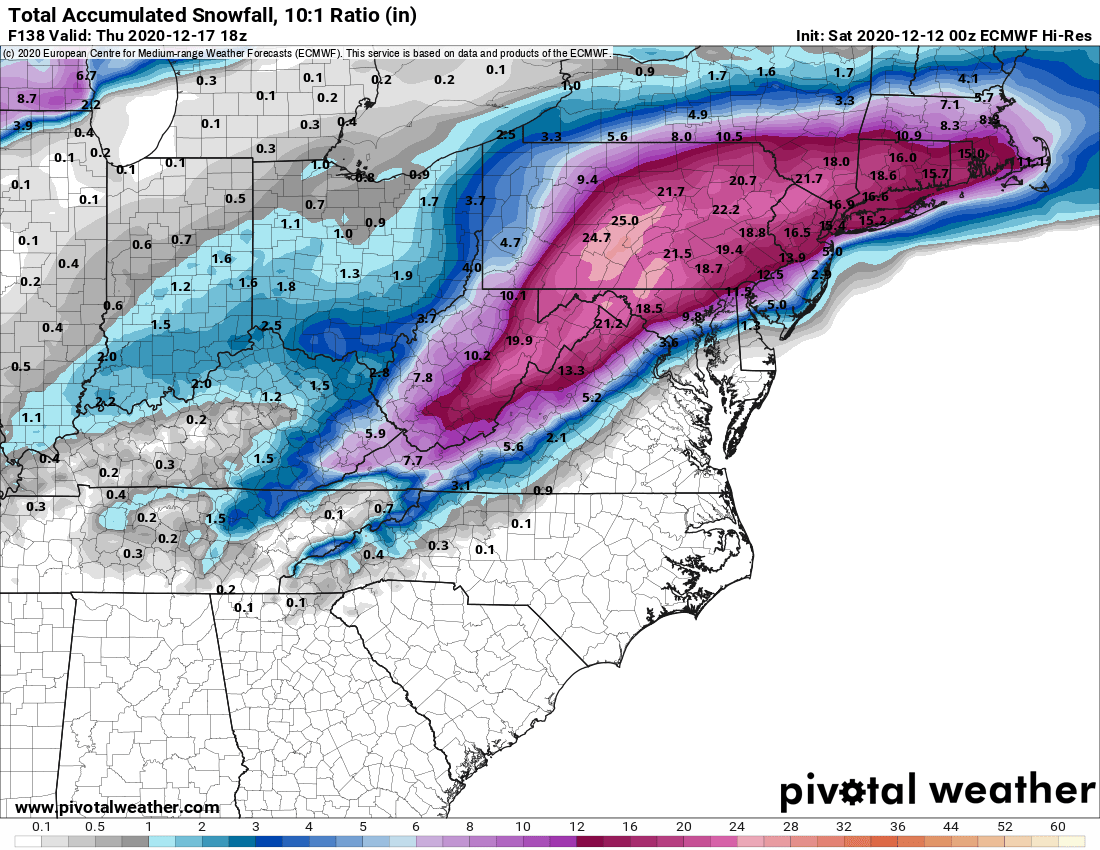
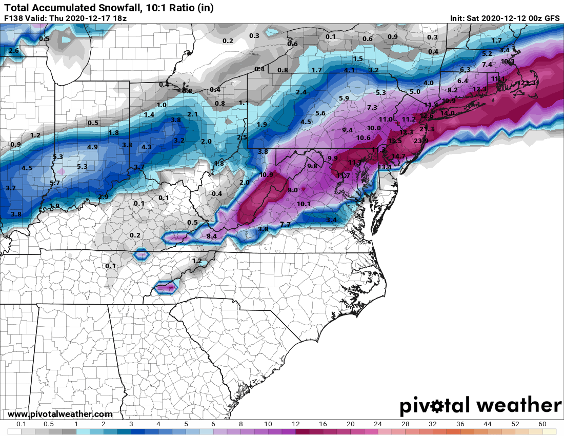
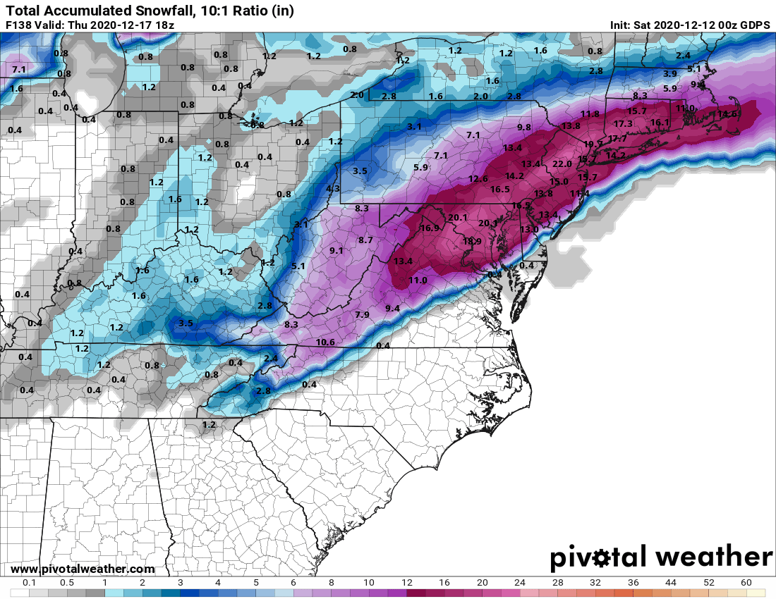
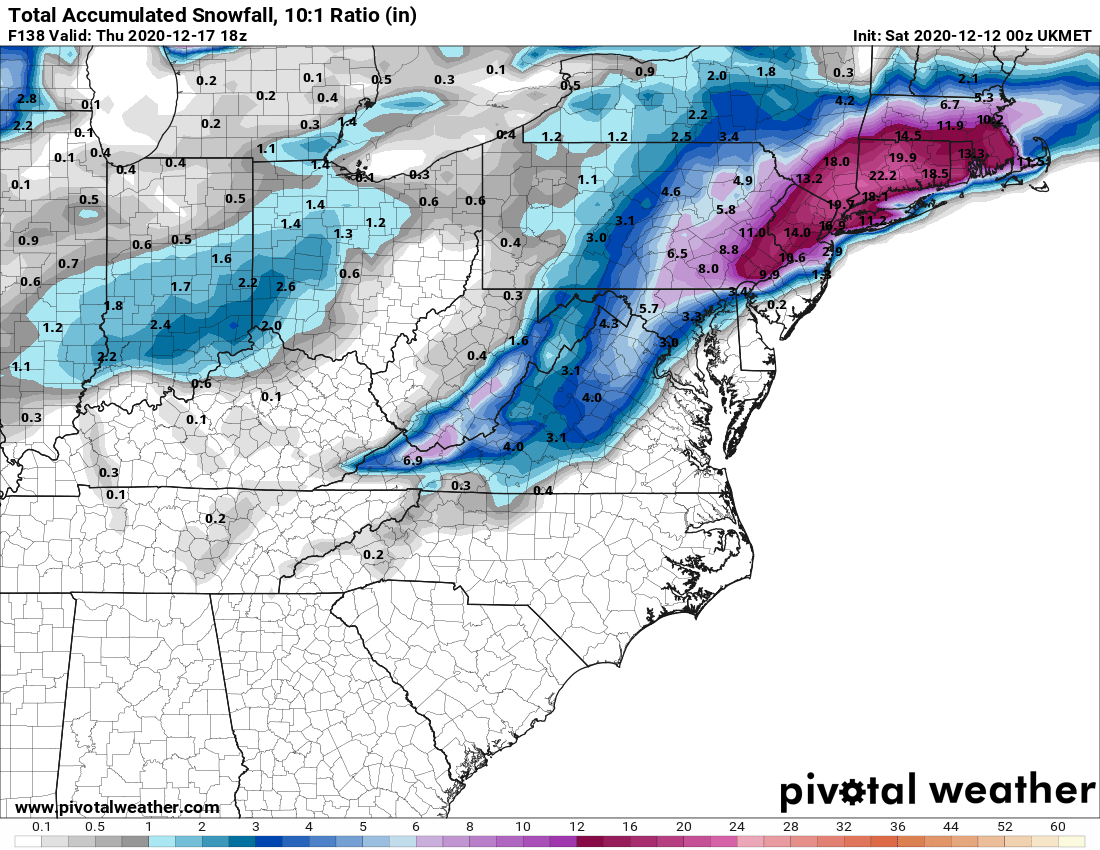
Specifically, the Euro is a major snowstorm NW of 95 (10"+) and a mix/rain along 95 and towards the coast. The Canadian is kind of the opposite, with a major snowstorm S/E of 95 (8"+) and several inches N/W of 95. The GFS shows mostly snow for everyone, but a bit less precip with a general 3-6" snowfall for most of the 95 corridor, with less towards the coast (some rain) and the UK is showing significant snowfall (3-6") only N of about 80 with sleet and mostly rain towards 95 and the coast. Lots more to come, I'm sure.

https://www.americanwx.com/bb/topic...-down-to-near-i80-next-week-14th-18th/page/5/
 
Winter is here . Do we have any idea of the timing of this thing yet ? Tuesday into Wednesday , Wednesday into Thursday ?
Thanks !
 
One thing that i can guarantee. Those models will change several dozen times and the snowier overdone solutions coming from NAM will be rallied behind
These threads are a lot more fun to follow when it’s 75 and sunny out!
 
One thing that i can guarantee. Those models will change several dozen times and the snowier overdone solutions coming from NAM will be rallied behind
The channel 11 weatherman said just that. Current thinking is NYC and areas north of 78 may see up to 6", with areas south, especially along the coast getting nothing. That said, got to go fire up the snowblower to invoke the reverse jinx.
 
  • Like
Reactions: okieKnight908
131223605_3876017915764911_3658602063110647308_o.png
 
Maybe this will be the year all you central Jersey people win the snow prize...or snow punishment depending on your perspective 🤷🏻‍♂️
 
Maybe this will be the year all you central Jersey people win the snow prize...or snow punishment depending on your perspective 🤷🏻‍♂️
Well, we did just finish the 2nd snowiest decade in 150 years for most of the Philly-NYC region, despite last year's whiff (if we had even gotten normal snowfall, we'd have been in first), so it's not like we've been snow starved.
 
The channel 11 weatherman said just that. Current thinking is NYC and areas north of 78 may see up to 6", with areas south, especially along the coast getting nothing. That said, got to go fire up the snowblower to invoke the reverse jinx.
Too far out to "predict" anything. We know there's likely to be a significant winter storm and significant snow is on the table for everyone, including the coast, but significant snow is not yet a given for anyone, as we're just too far out to know for sure.
 
Still 5+ days out, but 3 of the 4 major 12z (just came out) global models show a major snowstorm (8" or more - a lot more on the Euro and CMC) for most of the area starting Wednesday and going into Thursday early am. Nowhere near a forecast yet, as so many things can happen to derail snowstorms in this area, especially in early Dec, when the ocean is still fairly warm, but model runs at this point are simply about showing the potential for something significant.

Edit - forgot to add that there's also a chance of a few inches of snow on Monday afternoon/evening, mostly NW of the 95 corridor through the usual colder NW locations, with mostly rain along 95 and definitely at the coast.
 
Last edited:
I just checked the National Weather Service website forecast for my town, Bloomfield. They're predicting rain for Wednesday
 
If you'd like to read along with the rest of the weenies, here's the thread on the potential storm on AmericanWx and below that is a link to WxRisk's site (DT) - he's generally a skeptical curmudgeon, but he's all in on significant snowstorm for most of the area, given the great pattern, as we have a -NAO and a 50/50 low to hold the cold air in place, plus what looks to be the right jet stream/trough and eventual storm cyclgenesis and track along the coast. Still a long way off, but even the NWS is barking for snow 5 days out.

https://www.americanwx.com/bb/topic...dnesday-ending-early-thursday-dec-16-17-2020/

https://www.facebook.com/WxRisk
 
  • Like
Reactions: phs73rc77gsm83
Prediction: As with most snowstorms, the jackpot will be NW NJ and all other areas will have a mix and rain at the shore.
 
The channel 11 weatherman said just that. Current thinking is NYC and areas north of 78 may see up to 6", with areas south, especially along the coast getting nothing. That said, got to go fire up the snowblower to invoke the reverse jinx.
I may move my snow blower from the shed to the garage. That usually keeps the snow away.
Already taken care of... 😎

We're good, boys. We're good.
 
Welp, if OP predicted this I am going to guess it will be cloudy on Wed.
 
they only take credit for the ones they get right, its amazing how quickly the huge busts are forgotten. There have been several in the past few years, was their one last year? I forget
 
Since I’ve been taking forever to figure out what AWD SUV I want to buy, and only have very low to the ground cars that not great in any snow over an inch or two, I’m pretty sure we will have at least four feet of snow. Also my generator is on the fritz.

Snowmageddon is coming and it’ll be all my fault.
 
they only take credit for the ones they get right, its amazing how quickly the huge busts are forgotten. There have been several in the past few years, was their one last year? I forget
Do you think this one will be a bust?
 
I cleaned out the garage today and moved the snowblower closer to the garage door! I guess I will have to start it up tomorrow, I think the last time I used was 2 years ago. The 10hp Simplicity is ready for snow! ha
 
  • Like
Reactions: Knight Shift
Still 5+ days out, but 3 of the 4 major 12z (just came out) global models show a major snowstorm (8" or more - a lot more on the Euro and CMC) for most of the area starting Wednesday and going into Thursday early am. Nowhere near a forecast yet, as so many things can happen to derail snowstorms in this area, especially in early Dec, when the ocean is still fairly warm, but model runs at this point are simply about showing the potential for something significant.

Edit - forgot to add that there's also a chance of a few inches of snow on Monday afternoon/evening, mostly NW of the 95 corridor through the usual colder NW locations, with mostly rain along 95 and definitely at the coast.

Three of four of the major 12Z global models this afternoon showed a major snowstorm (8" or more) for most of the Philly-NJ-NYC region and all four of tonight's 12Z models show a major *8" or more) to historic (historic is 12-18" to me - we don't get too many of those) snowstorm on Wednesday afternoon through Thursday morning. I don't think I've ever seen this level of near model consensus 4.5 days out.

WxRisk/DT could end up being right on this one, as he's been honking on it for a few days given the great pattern, i.e., we have a -NAO (North Atlantic Oscillation Index) and a 50N/50W low to hold the cold air in place, plus what looks to be the right jet stream/trough approaching and eventual storm cyclgenesis and track along the coast; it's the last few items that have to mesh perfectly to get us major snowfall, which is why major snowfalls are fairly rare around here.

Doesn't guarantee it's going to happen, but it's starting to look like we're in for at least a moderate to significant snowfall, with the potential for much more. Of course, being this far out, numerous things can still happen to derail this, such as a further inland/warmer/wetter track or a further offshore/less precip track, but if we see anything like the track being advertised, with the cold air expected to be in place, this could be a pretty big snowstorm, even for the 95 corridor and maybe the coast (always at most risk for rain with the ocean being fairly warm this time of year). There could also be significant winds (blizzard conditions are in play) and some tidal flooding. Since this is so unusual, below are the snowfall maps for the storm.

One more point: the Euro is also showing 1-2" of snow on Monday along and just NE of 95 and 2-5" NW of 95 and especially N of 78 and the GFS is showing 1-3" or so SE of 95 and towards the coast with <1" NW of 95, while the NAM is showing a general 2-4" of snow for almost everyone (these have to be subtracted from the map below for the Weds event) and the UK/CMC are showing almost all rain and only near the coast, so oddly, much less consensus on an earlier event (but which is much more borderline with regard to having enough cold air).

https://www.weather.gov/phi/

https://www.americanwx.com/bb/topic...-17-2020/page/5/?tab=comments#comment-5725302

https://www.facebook.com/WxRisk

FKT5ycP.png


E5SyCSI.png


thnSKR9.png


pHkScI3.png
 
  • Like
Reactions: Postman_1
To be honest i haven't looked at one model yet or read the weenie board. When we get into the 72 hour window i will start looking
Over the many years I have noted:

>10 days (fantasy)
5-10 days (a general idea of where the weather will be)
0-5 days (pretty good)
 
  • Like
Reactions: RU848789
ADVERTISEMENT
ADVERTISEMENT