Would be nice to keep this thread at least somewhat on topic - there will be plenty of time to make fun of it later if it doesn't pan out.
Update on Fri/Sat (3/3-4) Winter Storm
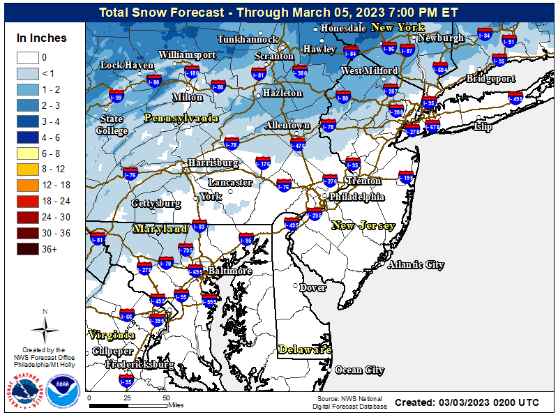
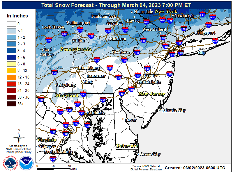
Debated a new thread for this, but we have quite a few posters N of 78 who might be interested in this event, so why not. Not much change in the forecast really. Looks like about all rain south of 78 (maybe 1/2" of snow/sleet down to a New Hope to Perth Amboy line, at best), with a good 1" or more of heavy rain being likely from late afternoon Friday through about sunrise on Saturday. The rain could cause some localized urban flooding, but is not expected to cause stream/river flooding. We'll also likely see 35-45 mph wind gusts (might see advisories) and some minor coastal flooding is possible, especially Saturday morning, so even though this doesn't look that wintry for many, it could be impactful.
Could be up to 1" of snow/sleet along 78 before the changeover to heavy rain and maybe 1-3" of snow/sleet along /N of 80 (and W of 287) before a later changeover to rain (late Fri/early Sat), as the low level cold air will hold on longest there, which could lead to 0.1-0.25" of freezing rain for far NW NJ (Sussex/NW Passaic), the Poconos (Carbon/Monroe), and Orange/Putnam in the Hudson Valley. Note that these areas could end up with several inches of sleet and snow if a couple of the models are correct. North of there and especially for the ski resorts in the Catskills, Adirondacks and most of New England, we should see heavy snow with 8-12" likely (and even up to 18" in spots), as per the 2nd map below.

The Coming Pattern Change
There is almost certainly a pattern change coming after most of this winter featured a La Nina pattern that was very warm and nearly snowless for most of the eastern US, resulting in record warm temps for many locations for both January and February. The La Nina regime is essentially over, the MJO (Madden Julian Oscillation) is forecast to move into region 8 in about a week and to stay there for a couple of weeks, and this is usually accompanied by colder than normal and stormy conditions in March in the eastern US with a neutral ENSO state (no La Nina).
These drivers are being reflected in medium term global models showing the months long western US trough/eastern US ridge pattern (which has caused so much snow/wintry weather out west and our warm/wet winter here) breaking down, with a ridge being established out west and up into Alaska, which should drive a troughing regime into the eastern US by late next week (by about 3/8), plus the forecast calls for Atlantic and Arctic "blocking" to develop, which should suppress the southeast ridge and funnel colder weather into the eastern US and which, in conjunction with the eastern US trough, often leads to coastal storms for the east coast - which are more likely to be wintry in this setup than in the pattern we've had.
The last time we had what looked to be a cold and possibly snowy pattern advertised was mid/late December, where we certainly got a very cold outbreak, but missed out on snow and then the pattern broke down unexpectedly, likely due to the strong La Nina conditions (this is all well explained in the attached video by DT/WxRisk); can't seem to find that thread, although it's posted elsewhere. So, while moving to a colder pattern is almost a certainty, it's far harder to predict snowstorms 7+ days into the future, but they are more likely than average in the coming pattern, especially after about 3/9.
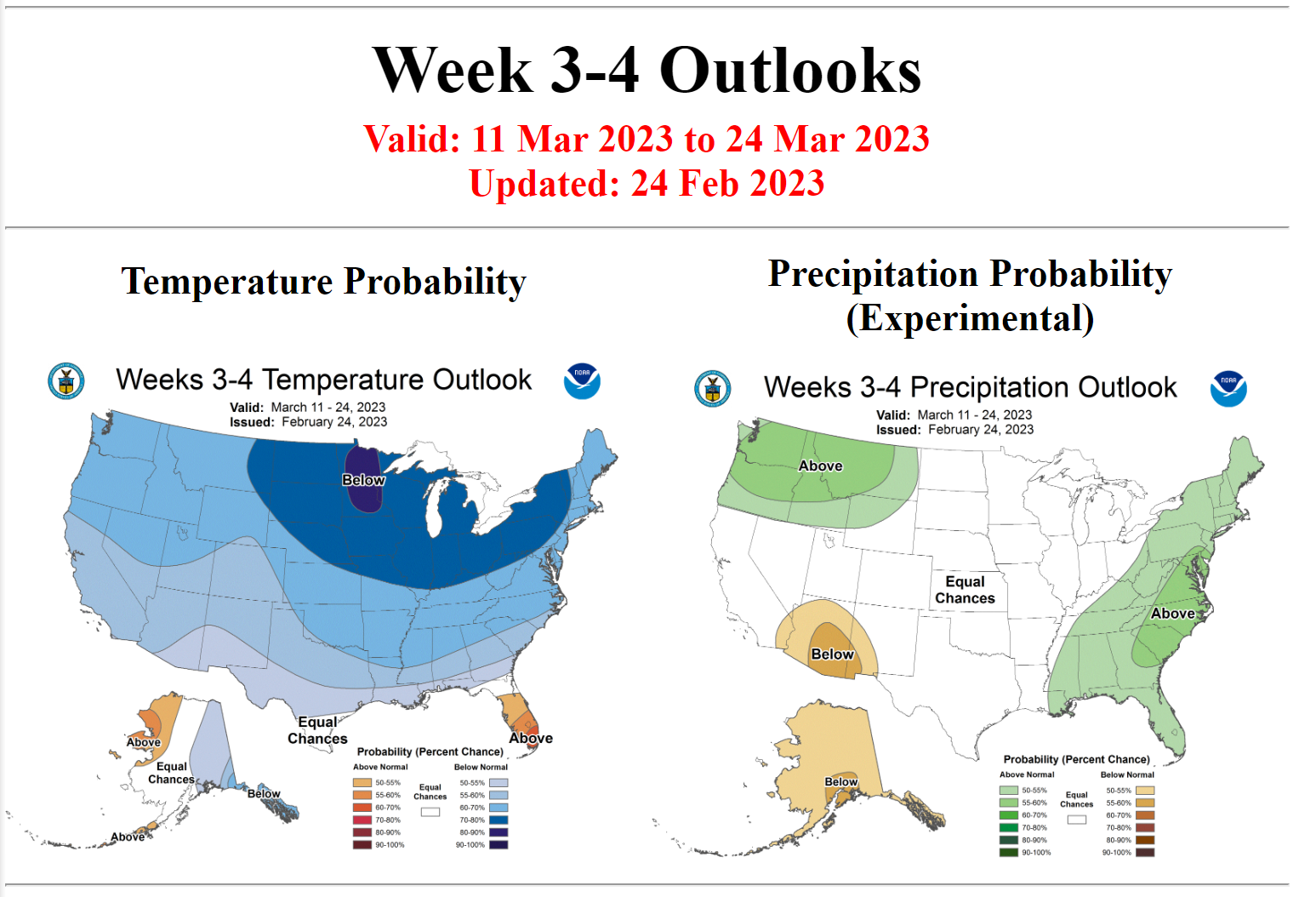
The Climate Prediction Center has our area seeing colder than normal weather (with normal precip) from 3/7-3/11 and their extended outlook, shown below, is for colder and wetter (which means possibly snowier) than normal conditions from 3/11-3/25. I will say this: I don't think I've ever seen a group of fairly grizzled meteorologists seem this excited for a pattern in years - probably not since March 2018, when we got ~25" of snow in March in NB/NYC - that was one of the 7 of 11 patterns I've posted about over the last 5+ years to come to fruition for both cold and snow. (10 of 11 have been correct just for temps).
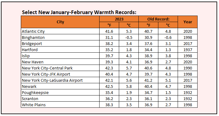
Lastly, in case anyone doubts how warm Jan/Feb were, look at the table below (from Don Sutherland on the weather boards) showing how many stations in the NE US had record warm Jan/Feb - and many would've had record warm meteorological winters (D/J/F) if not for the several days of brutal cold around Christmas.
Update on Fri/Sat (3/3-4) Winter Storm
Debated a new thread for this, but we have quite a few posters N of 78 who might be interested in this event, so why not. Not much change in the forecast really. Looks like about all rain south of 78 (maybe 1/2" of snow/sleet down to a New Hope to Perth Amboy line, at best), with a good 1" or more of heavy rain being likely from late afternoon Friday through about sunrise on Saturday. The rain could cause some localized urban flooding, but is not expected to cause stream/river flooding. We'll also likely see 35-45 mph wind gusts (might see advisories) and some minor coastal flooding is possible, especially Saturday morning, so even though this doesn't look that wintry for many, it could be impactful.
Could be up to 1" of snow/sleet along 78 before the changeover to heavy rain and maybe 1-3" of snow/sleet along /N of 80 (and W of 287) before a later changeover to rain (late Fri/early Sat), as the low level cold air will hold on longest there, which could lead to 0.1-0.25" of freezing rain for far NW NJ (Sussex/NW Passaic), the Poconos (Carbon/Monroe), and Orange/Putnam in the Hudson Valley. Note that these areas could end up with several inches of sleet and snow if a couple of the models are correct. North of there and especially for the ski resorts in the Catskills, Adirondacks and most of New England, we should see heavy snow with 8-12" likely (and even up to 18" in spots), as per the 2nd map below.
The Coming Pattern Change
There is almost certainly a pattern change coming after most of this winter featured a La Nina pattern that was very warm and nearly snowless for most of the eastern US, resulting in record warm temps for many locations for both January and February. The La Nina regime is essentially over, the MJO (Madden Julian Oscillation) is forecast to move into region 8 in about a week and to stay there for a couple of weeks, and this is usually accompanied by colder than normal and stormy conditions in March in the eastern US with a neutral ENSO state (no La Nina).
These drivers are being reflected in medium term global models showing the months long western US trough/eastern US ridge pattern (which has caused so much snow/wintry weather out west and our warm/wet winter here) breaking down, with a ridge being established out west and up into Alaska, which should drive a troughing regime into the eastern US by late next week (by about 3/8), plus the forecast calls for Atlantic and Arctic "blocking" to develop, which should suppress the southeast ridge and funnel colder weather into the eastern US and which, in conjunction with the eastern US trough, often leads to coastal storms for the east coast - which are more likely to be wintry in this setup than in the pattern we've had.
The last time we had what looked to be a cold and possibly snowy pattern advertised was mid/late December, where we certainly got a very cold outbreak, but missed out on snow and then the pattern broke down unexpectedly, likely due to the strong La Nina conditions (this is all well explained in the attached video by DT/WxRisk); can't seem to find that thread, although it's posted elsewhere. So, while moving to a colder pattern is almost a certainty, it's far harder to predict snowstorms 7+ days into the future, but they are more likely than average in the coming pattern, especially after about 3/9.
The Climate Prediction Center has our area seeing colder than normal weather (with normal precip) from 3/7-3/11 and their extended outlook, shown below, is for colder and wetter (which means possibly snowier) than normal conditions from 3/11-3/25. I will say this: I don't think I've ever seen a group of fairly grizzled meteorologists seem this excited for a pattern in years - probably not since March 2018, when we got ~25" of snow in March in NB/NYC - that was one of the 7 of 11 patterns I've posted about over the last 5+ years to come to fruition for both cold and snow. (10 of 11 have been correct just for temps).
Lastly, in case anyone doubts how warm Jan/Feb were, look at the table below (from Don Sutherland on the weather boards) showing how many stations in the NE US had record warm Jan/Feb - and many would've had record warm meteorological winters (D/J/F) if not for the several days of brutal cold around Christmas.