ADVERTISEMENT

OT: Minor to Moderate Snowfall Sunday (2/13) Morning; and a warm pattern for the 2nd half of Feb

RU848789

Legend
Gold Member
Jul 27, 2001
60,562
39,147
113
Metuchen, NJ
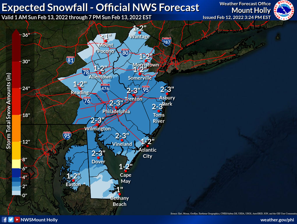
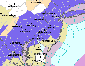
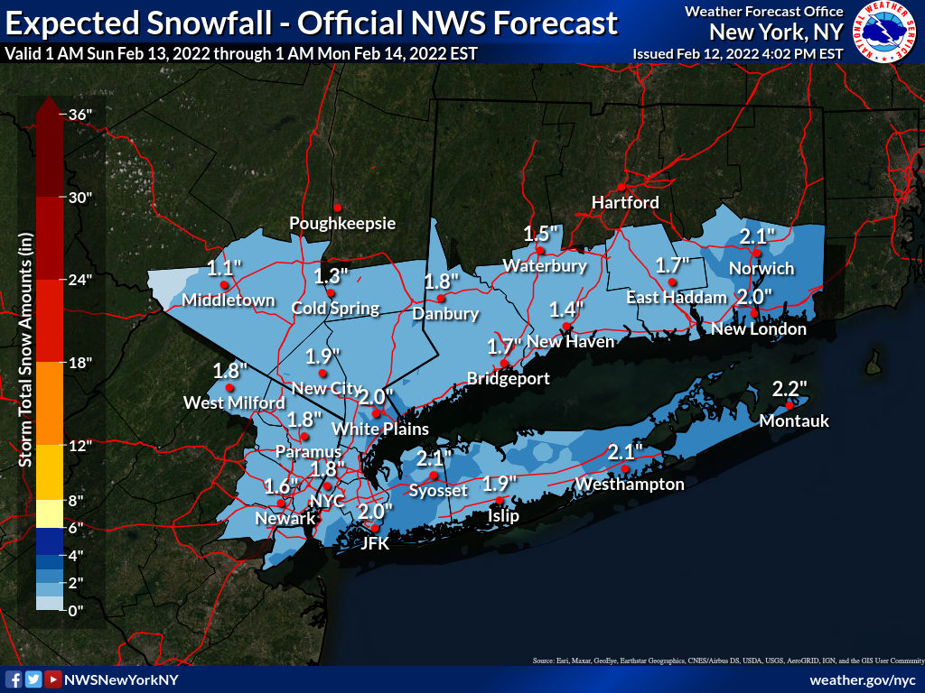
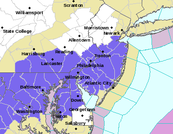
Need a new thread, I guess. Models continue to show increasing amounts of snow for our area and now the NWS-Philly has put up advisories for some of CNJ (Mercer, Middlesex and Monmouth, but not Somerset/Hunterdon) and all of SNJ/SEPA (except Cape May; the blue counties) for a general 2-3" of snow for all of the 95 corridor from Philly thru NJ to NYC and towards the coast starting around 1-2 am Sunday and going through the morning; areas well to the NW are only forecast to get 1-2", so no advisories there (3" advisory criterion). For me a minor snowfall is an inch to maybe 2" in spots whereas moderate is 2-4", so we're kind of between those definitions.

It's likely that with borderline temps, especially before about 4 am (temps for most should be at or just below 32F by 4-5 am), we'll see mostly accumulations on colder surfaces, but with high enough snowfall rates, we'll likely see some accumulations on roads, especially since the heaviest snow is expected between about 3 am and 9 am, when it'll be dark and/or the sun won't be high up yet. So driving before 9-10 am could be impacted, but it's very likely roads will be fine by lunchtime, unless the storm really overperforms and drops 3-5" (outside shot at that for those who see the heaviest bands). There's also some chance that this system underperforms, now that the accumulations have been upped, as some models are still only showing an inch or less for much of the region. We'll see shortly.

https://www.weather.gov/phi/

https://www.33andrain.com/topic/2090-super-bowl-special-213-14/page/7/

https://www.americanwx.com/bb/topic/56799-likely-light-snowfall-213-214/page/8/


LMRQgwJ.png


lqPSCeO.png


wDpqmpi.png
 
Last edited:
Well I've come to appreciate the weather threads. Useful when there is a significant storm, and fun when there's a bust.

Btw Upper Somerset County looks to be in good shape.👍
 
  • Like
Reactions: RU848789
There goes my leaf blower - broom method. Still not a big deal on a Sunday morning but a little more annoying. Hope everyone got out and enjoyed today. I did and came home to a huge Rutgers win. Great day!
 
  • Like
Reactions: miketd1
@RU848789 - what is with those maps showing snowfall to the tenth of an inch?
Well, that is what their internal model is forecasting, but it's interesting how sometimes they just post the maps with ranges (as per below), but no specific location amounts (to tenths of an inch), while other times they include the amounts. I like seeing the granularity of the tenths, mostly to show where gradients might be, not that they can actually be that precise with the forecast.

LOD5X3t.png
 
There goes my leaf blower - broom method. Still not a big deal on a Sunday morning but a little more annoying. Hope everyone got out and enjoyed today. I did and came home to a huge Rutgers win. Great day!
This is likely going to be a fairly wet snow, so a blower probably wouldn't work well. Also, if there is any snow on any paved surfaces after about 4 pm, it's going to freeze solid Sunday evening, with temps into the 20s by 5-6 pm and lows in the teens Monday morning
 
This is likely going to be a fairly wet snow, so a blower probably wouldn't work well. Also, if there is any snow on any paved surfaces after about 4 pm, it's going to freeze solid Sunday evening, with temps into the 20s by 5-6 pm and lows in the teens Monday morning
Actually, this is kind of a crappy scenario- wasn’t expecting it to be more of a wet snow coming in. Have to clear it early. Some people may be unpleasantly surprised if they’re lazy on Sunday and let it freeze.
 
  • Like
Reactions: MulletCork
Actually, this is kind of a crappy scenario- wasn’t expecting it to be more of a wet snow coming in. Have to clear it early. Some people may be unpleasantly surprised if they’re lazy on Sunday and let it freeze.
Good day to go outside late morning and clear off this nuisance snow and then enjoy your day.
 
  • Like
Reactions: RUPete
Actually, this is kind of a crappy scenario- wasn’t expecting it to be more of a wet snow coming in. Have to clear it early. Some people may be unpleasantly surprised if they’re lazy on Sunday and let it freeze.

Its not that much
 
Started with a mix rain and snow about 2am here in Linden. Changed to snow somewhere between 2:30 and 3am. Cars, grass, parking lot getting covered. Street is just wet now.
 
Well, that is what their internal model is forecasting, but it's interesting how sometimes they just post the maps with ranges (as per below), but no specific location amounts (to tenths of an inch), while other times they include the amounts. I like seeing the granularity of the tenths, mostly to show where gradients might be, not that they can actually be that precise with the forecast.

LOD5X3t.png

Woke up at 3:30 am and it was snowing moderately with a dusting on the colder surfaces; fell back asleep and then woke up again around 4:30 am and went outside and it's still snowing moderately (close to heavily) and we have 1.0" on the ground, including 1/4-1/2" on paved surfaces, already.

As expected, the snowfall rate is greater than the melting rate and now that we have a snow foothold on paved surfaces, the rest of the falling snow should accumulate on those surfaces, as it's down to 33F and should be at or below 32F in the next hour or so, so roads are going to be snow covered (at least non-treated ones). Looks like 2-3" should verify easily if this kind of rate keeps up.

Advisories have also been extended to the whole NWS-Philly area NW of 95 and for the NYC/NENJ metro and the Hudson Valley/LI for a general 1-3" of snow with up to 4" in spots (already 3" OTG at Vernon Valley), especially along and NW of 95, where 2-3" is more likely vs. 1-2" SE of 95 towards the coast as per the updated snowfall maps from the NWS.

LILBOsA.png


c4GrQQG.png


9hn1sGf.png
 
As of 5:00 am, we're up to 1.25" OTG, as intensity was a bit less the last 20 minutes or so. Temp down to 32F, so melting should no longer be an issue, at least not until 9-10 am when the sun is up in the sky a bit. Very pretty out there and it's great snowball snow...
 
Looking like a bust so far in Wall. No snow on driveway and looks like a mix of rain and snow.
Well, so far, you weren't supposed to have any snow yet, so that's not a bust. Rain should be changing to snow soon in your area though, but forecast snowfall was trimmed back to an inch to maybe 2". Will also likely take an hour or so of snow for you to start seeing accumulations, as temps are still 33-34F down there.
 
Some areas in the Lehigh Valley and NW NJ have 4" of snow already - big overperformer up there. Thinking 2-3" is a good call for the 95 corridor right now.
 
Well, so far, you weren't supposed to have any snow yet, so that's not a bust. Rain should be changing to snow soon in your area though, but forecast snowfall was trimmed back to an inch to maybe 2". Will also likely take an hour or so of snow for you to start seeing accumulations, as temps are still 33-34F down there.
I was going off the 2-3" you posted yesterday, and the inch we were supposed to have by now, which I did not want to have to deal with on my fire duty crew night. Thankfully, no calls overnight and did not realize we had the trimming back, but that's a good thing.
 
As of 5:00 am, we're up to 1.25" OTG, as intensity was a bit less the last 20 minutes or so. Temp down to 32F, so melting should no longer be an issue, at least not until 9-10 am when the sun is up in the sky a bit. Very pretty out there and it's great snowball snow...
As of 6:00 am, we're up to 1.50" OTG, as intensity as definitely lighter the last hour (1/4" fell). Intensity picked back up the last 10 minutes and flakes are now more dendritic/drier, presumably due to better growth up in the dendritic snow growth zone aloft and a colder column. 32F here.
 
Snowing, if you want to call it that, very light. Not sticking to anything but some cars. It's 32 degrees so not surprised.
 
JC with about an inch in the dog park, they got to play in it first, so it was still all white.
 
As of 6:00 am, we're up to 1.50" OTG, as intensity as definitely lighter the last hour (1/4" fell). Intensity picked back up the last 10 minutes and flakes are now more dendritic/drier, presumably due to better growth up in the dendritic snow growth zone aloft and a colder column. 32F here.
As of 7:00 am, up to 1.75" with fairly light intensity most of the last hour, but picking back up again now. Temp down to 31F. HRRR shows another inch or so for most through about noon, but at fairly light rates of 1/4" per hour, I doubt we'll see that much more accumulate with the indirect sunlight becoming more of an issue for melting by 9-10 am. Guessing we'll end up with 2-2.5" here.
 
No sticking to roads here in the Boro. Not worth me plowing today though when I picked up my Bacon Egg and Cheese at the Hillsborough Deli I overheard Claire asking Doreen if she was going to call her snow guy and see if he was going to plow her before the Super Bowl.
 
  • Haha
Reactions: goru1869
Really nice band just popped up for Southern Somerset through most of Middlesex/Union - coming down nicely now with decent sized dendrites.

q15Pau6.png
 
Just got back from dropping my daughter off at work in Pennington and we have ~1’5” in Belle Mead/Montgomery - main road are fully clear (just wet) and some side roads might have a sections with a slushy coating that could be a bit slick (so don’t speed and it’s fine).

Moderate snow with bigger flakes in the last half hour or so, but the radar looks to be falling apart in the next 30 min so we might get 2” total - a minor snow for sure (likely would not even make more than a mention on the news when I was a kid).
 
  • Like
Reactions: RU848789
As of 7:00 am, up to 1.75" with fairly light intensity most of the last hour, but picking back up again now. Temp down to 31F. HRRR shows another inch or so for most through about noon, but at fairly light rates of 1/4" per hour, I doubt we'll see that much more accumulate with the indirect sunlight becoming more of an issue for melting by 9-10 am. Guessing we'll end up with 2-2.5" here.
As of 8:00 am we're up to 2.25" OTG with 1/2" the last hour. 31F. Here's a pretty picture...worth a walk outside y'all. Also, you can see from the pic that the lightly traveled road across the street is still fully snow-covered, while the busier street right in front of our house is only partly slush-covered, as traffic has warmed things up a bit and melted some of the snow.


May be an image of 1 person, car, snow and road
 
What is the estimated end time for CNJ?
The steady accumulating snow is just about over for CNJ, except near the coast, which will last a bit longer. We'll likely still get some bouts of snow during the 10 am to 2 pm timeframe, but light snowfall rates will likely be just enough to cancel out melting rates from the indirect sun, meaning additional accumulations will be light and accumulations on any paved surfaces are just about over.
 
  • Like
Reactions: RUPete
Here in Cherry Hill, it is snowing very lightly. There is snow on the grass and roofs, but none on paved surfaces. The temperature is 33. We'll see how the morning goes.
 
Just got back from dropping my daughter off at work in Pennington and we have ~1’5” in Belle Mead/Montgomery - main road are fully clear (just wet) and some side roads might have a sections with a slushy coating that could be a bit slick (so don’t speed and it’s fine).

Moderate snow with bigger flakes in the last half hour or so, but the radar looks to be falling apart in the next 30 min so we might get 2” total - a minor snow for sure (likely would not even make more than a mention on the news when I was a kid).
Agree.
 
Still only a coating on cars and grass/greenery here in south Wall with very light snowfall.
 
Just wet pavement and streets here in Hamilton. Cars and grass covered. More of a nuisance snow then anything. Sucks cause I just washed the trucks during the nice weather.
 
The steady accumulating snow is just about over for CNJ, except near the coast, which will last a bit longer. We'll likely still get some bouts of snow during the 10 am to 2 pm timeframe, but light snowfall rates will likely be just enough to cancel out melting rates from the indirect sun, meaning additional accumulations will be light and accumulations on any paved surfaces are just about over.
May have spoken too soon - could have just been a lull. NWS update just said it looks like accumulating snow in NWNJ (esp Warren/Sussex) and the Lehigh Valley, which overperformed with 3-5" of snow, so far, is over, but that they're seeing snow bands blossoming over SWNJ/SEPA (clear on the radar), which should impact the 95 corridor and much of SNJ and the coast for the next several hours with another inch or so possible, although that snow will very likely only accumulate on colder surfaces now that the sun is up and stronger.

Area Forecast Discussion
National Weather Service Mount Holly NJ
912 AM EST Sun Feb 13 2022

NEAR TERM /THROUGH TONIGHT/...
There was a bit of a lull in the snowfall rates this morning.
However, another band of snow was beginning to develop and
advect northeastward along the Interstate 95 Corridor and
vicinity around 9:00 AM. That should continue to be the trend
during the balance of the morning with the band drifting
eastward and off the coast late this afternoon. With
temperatures at or just above freezing, additional snowfall
amounts in those area should be no more than an inch or two.

Meanwhile, for the areas to the northwest of the Interstate 95
Corridor where the overnight snow over-performed, the current
trends suggest little additional snow accumulation, with the
snow mostly coming to an end by afternoon.

The Winter Weather Advisories will be left in place and may
need to be adjusted around midday.
 
As of 8:00 am we're up to 2.25" OTG with 1/2" the last hour. 31F. Here's a pretty picture...worth a walk outside y'all. Also, you can see from the pic that the lightly traveled road across the street is still fully snow-covered, while the busier street right in front of our house is only partly slush-covered, as traffic has warmed things up a bit and melted some of the snow.


May be an image of 1 person, car, snow and road

As of 9:00 am, we have 2.6" of snow (only 1/10th of an inch the last hour) and I just cleared the snowboard (every 6 hours), so let's see if we get much more or not. I'm guessing another 1/2" given that we have some snow bands incoming from the SW. It's 32F here and will stay around 32F for the next several hours before dropping into the 20s this evening. Just shoveled as we have enough on the driveway/sidewalks that won't melt before this evening and I don't want frozen slush for the next 2 days.
 
ADVERTISEMENT
ADVERTISEMENT