ADVERTISEMENT

OT: Official Hurricane Irma Thread

The winning the lottery how about now

You said you're near the FL/AL border, right? I think you're still in the clear. The turn has started, which will bring some interaction with the west coast of Florida well before it gets to the panhandle.
 
Hoping for trpical conditions at this point bc every time I see a model the cone is closer & closer! Thx for the info
 
Back from the shit show and some family obligations. Just catching up on Irma. Irma at 125 mph and the turn to the north has finally commenced. Storm officially forecast to strengthen to 140 mph, as it goes over some of the warmest waters on Earth (90F) between Cuba and the Keys before landfall - intensity forecasts are notoriously difficult, so it could be stronger or weaker than 140 mph when it hits the westernmost Keys. Landfall will probably be on Key West and then it's going to be a close call on whether Irma will make landfall anywhere on the Gulf Coast or not.

Could go right up the coast without making landfall, but with the eastern part of the eyewall, with the strongest winds raking the immediate coast. Will probably not make landfall in Naples - Tampa is the most likely place for a 2nd landfall (with 115-120 mph winds if it hits Tampa), as it juts out just a bit into the Gulf. Not making landfall, in some ways, is worse, as it will allow the storm to maintain its strength better, as it moves up the coast - if it doesn't make any Gulf Coast landfall, then Irma could retain more of its strength when it heads up into the Big Bend area of the Panhandle south of Tallahassee - instead of 75-80 mph winds at that point, winds could still be up near 100 mph.

In addition to the winds, the storm surge in SW Florida (all the way up to Fort Myers) and the Keys is likely to be at least 6-12' in places, which would be catastrophic for many buildings; storm surge will evern still be 3-5' all the way around to Miami, but should be less on the east coast north of Miami. And most of Florida will be seeing 10-20" of rain, plus scattered tornaodes are probable almost anywhere. Given how large Irma is with hurricane force winds extending nearly 100 miles from its center, Cat 1 hurricane conditions (75-85 mph) are still expected on the South Florida east coast, south of West Palm Beach.

21558713_10212120167113466_3559897101518530393_n.jpg
 
Damn, my buddy is in Key West right now, I was hoping it would keep going west. Eff!
Key West will be ground zero for this storm. Forecast to be 140 mph at landfall there, but could be even more, as intensity forecasts are notoriously difficult.Key West is one of my favorite places and I'm saddened to think of the devastation that is likely to occur there.
 
Key West will be ground zero for this storm. Forecast to be 140 mph at landfall there, but could be even more, as intensity forecasts are notoriously difficult.Key West is one of my favorite places and I'm saddened to think of the devastation that is likely to occur there.

Well at least the tourist trap bars will get a good rinsing out.

Key West Chickens have been Evac-ed. Hemingway cats did NOT get evac-ed. The cats will be fine.
 
The 11 pm NHC update is out and surprisingly, the NHC is no longer thinking Irma will intensify much further and will be at about 125 mph when it strikes Key West (not 140 mph, which was the forecast 6 hours ago). If that verifies, the people of the Keys and SW Florida will still be hammered with horrific conditions, winds, storm surge, rainfall, tornadoes, etc., but it won't be quite as bad as it could've been and they can thank Cuba for that, as the prolonged interaction of Irma with Cuba definitely made a big difference in Irma's strength (it was 160 mph yesterday evening). Need some sleep...

21463052_10212120973893635_5139590790807910197_n.jpg

Well, Irma has strengthened back to Cat 4 status, with winds of 130 mph and a pressure of 929 mbar and is just 30 miles SSE of Key West and it's moving NNW at about 8 mph, meaning the eyewall, with the highest winds is about to hit Key West and the eye should make landfall there in about 2-3 hours.

Keep in mind that hurricane winds extend over 70 miles from Irma's center and hurricane force wind gusts extend about 130 miles from the center, so even the east coast of Florida is going to see at least hurricane force wind gusts, especially south of about West Palm Beach, where sustained Cat 1 (75-85 mph) winds are likely.

Damage to the Keys and SW Florida along the coast and inland maybe 20-30 miles from the Gulf Coast is likely to be catastrophic from both winds and 6-12 foot storm surges, especially since Irma could strengthen a bit more in the next 6 hours (maybe to 135 mph). Irma will be moving just offshore of the Gulf Coast from the Keys to about Tampa early Monday morning, where it may make a 2nd landfall with winds in the 110-120 mph range, as Irma is going to start experiencing increased shear, weakening the storm. 10-20" rains will fall statewide and scattered tornadoes will also be likely statewide.

After that, Irma will definitely make another landfall south of Tallahassee on the panhandle in the Big Bend area Monday evening with winds of 85-90 mph and then will weaken quickly as it moves through western Georgia, with winds down to 45 mph as it nears Montgomery, Alabama Tuesday morning.

All in all, maybe not quite the storm we thought a couple of days ago, before the weakening from Cuba and the western shift in the track, but still a formidable storm that will do serious damage.

21462707_10212122489051513_3150557817414615741_n.jpg
 
Key West direct hit. This is not what I wanted to find out. Praying hard.

Key West is NOT taking a "direct hit". Right now, per the radar, Key West is about 10 miles off the edge of the western eyewall. Big Pine Key is currently moving into the RFQ portion of the eyewall.

One more important point - the south side of this storm has been shredded by Cuba. Convection has broken down and there is a massive dry slot that's currently working its way into the storm from the south. It's trying to fill in, now that that part of the circulation is back over water, but my guess is that several hours from now the Keys and southeast Florida are going to be seeing a much weaker storm.
 
  • Like
Reactions: Finster Baby
Well at least the tourist trap bars will get a good rinsing out.

Key West Chickens have been Evac-ed. Hemingway cats did NOT get evac-ed. The cats will be fine.

Been watch the live cam feed from Sloppy Joe's bar in Key West since July and as of last night the feed is gone. They put sand bags all along the doors but I imagine that wont do any good.
 
I'm concerned about Cape Coral and storm surge because of all the canals that run through that town that feed into the river and then the GOM. I've only seen one report on TV mention this.
 
I'm concerned about Cape Coral and storm surge because of all the canals that run through that town that feed into the river and then the GOM. I've only seen one report on TV mention this.
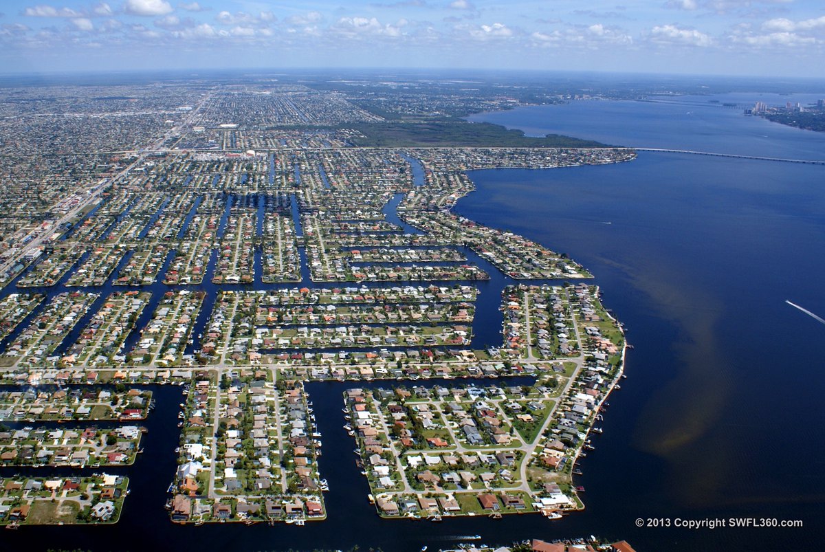
Sadly Cape Coral is in a very bad place.
 
Key West caught a bit of a break, as the center of Irma went 20-30 miles to its east over Big Pine Key, instead of directly overhead as it looked like it was going to do several hours ago. Still got part of the western (weaker) eyewall. That more northerly motion the last few hours might mean 2nd landfall near Naples/Marco Island instead of staying off the coast until Tampa. Awesome, yet terrible picture...

21462376_10212123512997111_2795380903630631101_n.jpg
 
Last edited:
  • Like
Reactions: Finster Baby
The Weather channel is doing a yeomans job.
Agree - been talking them up the past couple of years, as they've staffed up with top quality meteorologists in the areas of tropical weather (they have friggin' Rick Knabb, former NHC Director and he's been amazing, as has been Bryan Norcross a very well known hurricane expert and they've always excelled at field coverage), snowstorms, and severe weather.
 
Extreme Wind Warning for Collier County (SW FL/Naples) for major hurricane force winds above 115 mph. Scary stuff.

Extreme Wind Warning
National Weather Service Miami FL
1225 PM EDT SUN SEP 10 2017

The National Weather Service in Miami has issued a
* Extreme Wind Warning for...
Southwestern Collier County in southwestern Florida...
* Until 330 PM EDT

* At 1223 PM EDT, National Weather Service Doppler radar indicated
extreme winds above 115 mph, associated with the eyewall of
Hurricane Irma, were approaching the coast 10 miles south of
Everglades City, moving north at 15 mph. This is an extremely
dangerous and life-threatening situation!

* Locations impacted include...
Naples, Marco Island, Chokoloskee, Golden Gate Estates and
Everglades City.

http://www.weather.gov/mfl/
 
Tornado warnings and watches over much of Florida, also. Several cells with rotation are being observed just off the Central Florida East Coast, from Port St. Lucie to Daytona Beach, including Vero Beach, where my dad is hunkering down. Hurricane force winds are also forecast to make it all the way to the SE coast of Florida, south of West Palm Beach.

The next 8-12 hours are going to be the worst, as the storm works its way up the coast at only about 9-10 mph from Naples, where it should make landfall in about 2 hours to Fort Myers (in about 5 hours) to Tampa (in about 12 hours) and will only accelerate a little bit. The storm will likely stay right on the coast for that whole path, keeping the worst winds from the eyewall right on top of those major cities. Dry air will start impacting Irma north of Tampa, weakening the storm in conjuntion with much of the storm being over land, including the eyewall (probably).

Also, while there is essentially "negative" storm surge on the Gulf Coast, north of Irma now, given winds out of the east (offshore), as Irma passes by each coastal location and the storm moves to the north of those locations, all of those cities will then get hammered with winds out of the west, causing potentially catastrophic 6-12 foot storm surges for SW FL and 5-9 foot storm surges north of Naples. Pretty bad forecast.

21462691_10212124606184440_1399785262519781025_n.jpg

http://www.weather.gov/mfl/
 
Numbers, my in-laws are evacuated from Boca Grande on Gasparilla Island, northwest of Ft. Myers. Can you tell me if they're taking a direct hit?
 
As of 2 pm, Irma back down to Cat 3, at 120 mph; about to make landfall near Naples or will just slightly miss Naples (the center), but even it does, the eastern eyewall (strongest part) is about to strike Everglades City, Naples, Marco Island, etc.

https://mobile.twitter.com/hashtag/StormSurge?src=hash

Also, reports of more surge than expected in the Miami area, with up to 3 feet in the streets around the Miami River, which wasn't even an evacuation zone. And the winds on the east coast are frequently gusting at Cat 1/Cat 2 levels with these squall bands rotating around Irma - with embedded tornadoes.
 
Numbers, my in-laws are evacuated from Boca Grande on Gasparilla Island, northwest of Ft. Myers. Can you tell me if they're taking a direct hit?

Fort Myers will be hit by Irma's eastern eyewall (strongest part of the storm) in about 4 hours, assuming the eye, itself, doesn't come inland there; Boca Grande, itself, 15-20 miles east of Fort Myers, is even more likely to have the eye going over it. Things are going to be very bad at that pont (110-120 mph winds and 5-10' of storm surge in much of the area).
 
  • Like
Reactions: MorrisAsh
With the rain the visibility at Marco Isl is 20 feet with 110 mph winds. Mike Seidel is standing in thigh deep water in the streets of Miami
 
Last edited:
Landfall at St. Marco Island at 3:35 pm as a Cat 3, with 115 mph sustained winds and a 130 mph gust just recorded. As Irma passes each location on the Gulf Coast, winds will come around from the west and 5-10' storm surges will then hit much of the coast up to Fort Myers and maybe Tampa, although the storm is obviously weakening with the land interaction and dry air intrusion from the NW. .

Hurricane Irma Tropical Cyclone Update
NWS National Hurricane Center Miami FL AL112017
335 PM EDT Sun Sep 10 2017
...CENTER OF HURRICANE IRMA MAKES LANDFALL AT MARCO ISLAND...
The center of Hurricane Irma made landfall in Marco Island in
southwest Florida at 3:35 pm EDT as a Category 3 hurricane.
A 130 mph wind gust was recently reported by the Marco Island Police
Department.
SUMMARY OF 335 PM EDT...1935 UTC...INFORMATION
----------------------------------------------
LOCATION...25.9N 81.7W
OVER MARCO ISLAND
ABOUT 15 MI...25 KM SSE OF NAPLES
MAXIMUM SUSTAINED WINDS...115 MPH...185 KM/H
PRESENT MOVEMENT...N OR 350 DEGREES AT 12 MPH...19 KM/H
MINIMUM CENTRAL PRESSURE...940 MB...27.76 INCHES
 
CNN is broadcasting from Naples, eye wall is pounding their correspondants right now
 
95 mph sustained winds and a 135 mph gust in Naples. Mike Bettes from TWC is live in Naples struggling to stay upright in this. Wild. And maybe a little crazy.
 
Landfall at St. Marco Island at 3:35 pm as a Cat 3, with 115 mph sustained winds and a 130 mph gust just recorded. As Irma passes each location on the Gulf Coast, winds will come around from the west and 5-10' storm surges will then hit much of the coast up to Fort Myers and maybe Tampa, although the storm is obviously weakening with the land interaction and dry air intrusion from the NW. .

Hurricane Irma Tropical Cyclone Update
NWS National Hurricane Center Miami FL AL112017
335 PM EDT Sun Sep 10 2017
...CENTER OF HURRICANE IRMA MAKES LANDFALL AT MARCO ISLAND...
The center of Hurricane Irma made landfall in Marco Island in
southwest Florida at 3:35 pm EDT as a Category 3 hurricane.
A 130 mph wind gust was recently reported by the Marco Island Police
Department.
SUMMARY OF 335 PM EDT...1935 UTC...INFORMATION
----------------------------------------------
LOCATION...25.9N 81.7W
OVER MARCO ISLAND
ABOUT 15 MI...25 KM SSE OF NAPLES
MAXIMUM SUSTAINED WINDS...115 MPH...185 KM/H
PRESENT MOVEMENT...N OR 350 DEGREES AT 12 MPH...19 KM/H
MINIMUM CENTRAL PRESSURE...940 MB...27.76 INCHES

Reports of water levels rising over 3 feet in 20 minutes south of Naples after the storm passed and winds started coming out of the west, on-shore. Also, a 142 mph gust recorded at the Naples airport.
 
5 pm NHC advisory is out and no surprise that Irma has been downgraded to a Cat 2 storm with 110 mph winds, given the land interaction and shear/dry air intrusion from the west. Irma is forecast to continue going up the Gulf Coast and to be down to 85-90 mph when it reaches the Tampa area in ~12 hours and then down to 65-70 mph and no longer a hurricane, which it reaches the Tallahassee area in 24 hours (and it'll be dissipating quickly as it then travels through GA/AL)

Also, reports of water levels rising over 3 feet in 20 minutes south of Naples after the storm passed and winds started coming out of the west, on-shore. In addition, a 142 mph gust recorded at the Naples airport. Storm surge is now the major story to watch...as well as scattered tornadoes well to the NE of the storm.

21463187_10212126000899307_1590975710893606955_n.jpg
 
  • Like
Reactions: Rutgers8086
95 mph sustained winds and a 135 mph gust in Naples. Mike Bettes from TWC is live in Naples struggling to stay upright in this. Wild. And maybe a little crazy.
Pretty cool now seeing Bettes in the calm eye of the hurricane in Naples. Not for long, though.
 
95 mph sustained winds and a 135 mph gust in Naples. Mike Bettes from TWC is live in Naples struggling to stay upright in this. Wild. And maybe a little crazy.
I really thought that one gust was going to knock him down flat. Then he's standing in the eye perfectly calm.
 
The good news is that the Keys and the east coast from Miami south are going to be coming out if it over the next couple of hours. Already we're seeing wind speeds reported out of Key West of about 40 mph. I would expect that we'll start hearing reports of how they fared, very shortly.
 
Last I saw, 2 cranes in Miami have been knocked down so far.
 
Funniest thing I've seen on the weather board: there's a pic of a manatee, below, in a canal near Naples, I believe, that had emptied out due to the off-shore winds, and some guy said, "If that manatee had taken the evacuation orders seriously then he wouldn't be in that situation now." Feel badly for the manatee, but that was genius.

received_10155597126837086.jpeg.42b3b24f7ff3be705dbd090c6abbd251.jpeg
 
ADVERTISEMENT
ADVERTISEMENT