

Colleges
- American Athletic
- Atlantic Coast
- Big 12
- Big East
- Big Ten
- Colonial
- Conference USA
- Independents (FBS)
- Junior College
- Mountain West
- Northeast
- Pac-12
- Patriot League
- Pioneer League
- Southeastern
- Sun Belt
- Army
- Charlotte
- East Carolina
- Florida Atlantic
- Memphis
- Navy
- North Texas
- Rice
- South Florida
- Temple
- Tulane
- Tulsa
- UAB
- UTSA
- Boston College
- California
- Clemson
- Duke
- Florida State
- Georgia Tech
- Louisville
- Miami (FL)
- North Carolina
- North Carolina State
- Pittsburgh
- Southern Methodist
- Stanford
- Syracuse
- Virginia
- Virginia Tech
- Wake Forest
- Arizona
- Arizona State
- Baylor
- Brigham Young
- Cincinnati
- Colorado
- Houston
- Iowa State
- Kansas
- Kansas State
- Oklahoma State
- TCU
- Texas Tech
- UCF
- Utah
- West Virginia
- Illinois
- Indiana
- Iowa
- Maryland
- Michigan
- Michigan State
- Minnesota
- Nebraska
- Northwestern
- Ohio State
- Oregon
- Penn State
- Purdue
- Rutgers
- UCLA
- USC
- Washington
- Wisconsin
High School
- Illinois HS Sports
- Indiana HS Sports
- Iowa HS Sports
- Kansas HS Sports
- Michigan HS Sports
- Minnesota HS Sports
- Missouri HS Sports
- Nebraska HS Sports
- Oklahoma HS Sports
- Texas HS Hoops
- Texas HS Sports
- Wisconsin HS Sports
- Cincinnati HS Sports
- Delaware
- Maryland HS Sports
- New Jersey HS Hoops
- New Jersey HS Sports
- NYC HS Hoops
- Ohio HS Sports
- Pennsylvania HS Sports
- Virginia HS Sports
- West Virginia HS Sports
ADVERTISEMENT
Install the app
How to install the app on iOS
Follow along with the video below to see how to install our site as a web app on your home screen.
Note: This feature may not be available in some browsers.
You are using an out of date browser. It may not display this or other websites correctly.
You should upgrade or use an alternative browser.
You should upgrade or use an alternative browser.
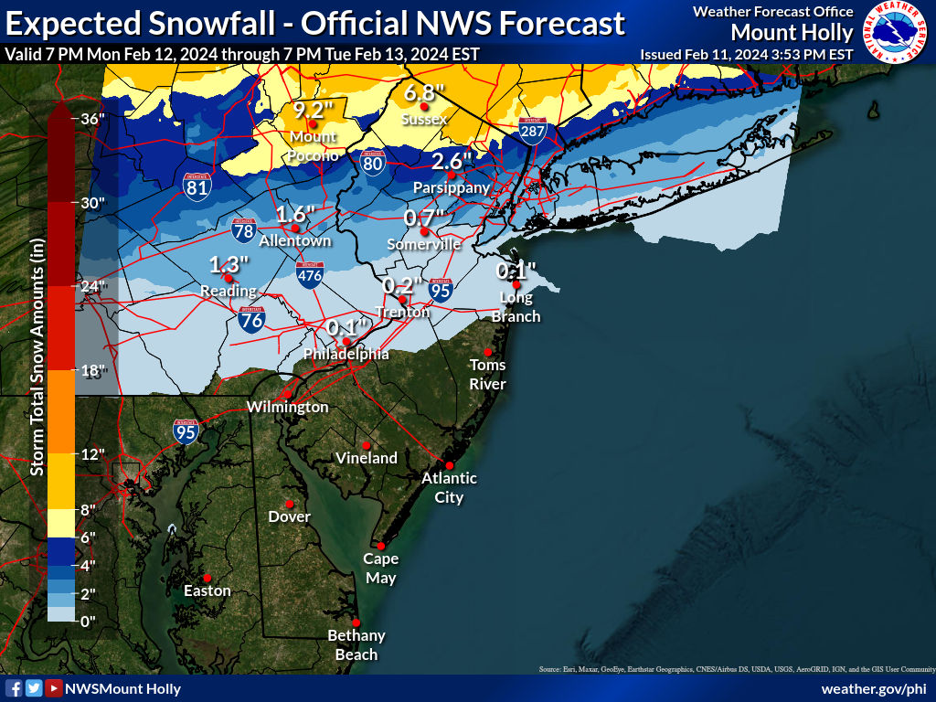
OT: Significant (CNJ) to Major (Along/N of 78) Winter Storm Likely on Tuesday (2/12-13; much less uncertainty on outcome)
- Thread starter RU848789
- Start date


Thanks, but the JW Eurostep is a thing of beauty. Goddamn, but it pisses me off that it took so long to clear him - we'd easily be in the field of 64 if he had played all season, IMO...This is good stuff. But I'm more interested in the Jeremiah Williams Euro Step.
https://www.facebook.com/watch/?ref=embed_video&v=678248909795111 I have to admit, being an ameateur weather man is a noble venture.
F@ck me.
I need to find some more salt tomorrow.
Guess kids will be home Tuesday at minimum.
There are going to be some major precip type and ratio issues with this. Very marginal temp profile yet again. I’m seeing these 10:1 maps getting tossed around like a hand grenade but I would favor something closer to 5-7:1. Heavier bursts will allow for accumulations but will not change the ratio. Plus a sleet signal to boot.
As a side note, I have no idea what MT holly is doing issuing a WSW for non-warning criteria snow. They address it in the text, saying if the forecast holds they will go with an advisory. I don’t know if this is a new NWS policy or Mt Holly went rogue, but this is very confusing. People see winter storm watch and think big things, not a 1-4 event.
As a side note, I have no idea what MT holly is doing issuing a WSW for non-warning criteria snow. They address it in the text, saying if the forecast holds they will go with an advisory. I don’t know if this is a new NWS policy or Mt Holly went rogue, but this is very confusing. People see winter storm watch and think big things, not a 1-4 event.
The Euro shows temps in the mid-30s near 95, so snow ratios/melting will be somewhat of an issue. The Kuchera maps have only about half the accumulation south of 78 than the 10:1 ratio maps, like you posted, do. That's part of the reason I haven't been posting maps other than the NBM and just discussing the maps including 10:1 and Kuchera info. Here's what I mean - look at the difference for Kuchera vs. 10:1. I've often been critical of the simplistic Kuchera algorithm, but in situations where the max column temp is as high as 35-36F, Kuchera is probably better than 10:1.


See my reply to Tango about ratios. I would also use about 5-7:1 along 95 and SE, but closer to 10:1 along 78 and north. Also some models are just running colder, like the NAM, where the 10:1 maps are fine. I also think ratios up in the column may actually be quite good once we get the cold conveyor belt cranking with good growth in the DGZ, even along 95, but melting will also be an issue until accumulations start with higher intensity snow. Makes it so tough to know how much snow folks will get on roads vs. yards which will greatly depend on where they are.There are going to be some major precip type and ratio issues with this. Very marginal temp profile yet again. I’m seeing these 10:1 maps getting tossed around like a hand grenade but I would favor something closer to 5-7:1. Heavier bursts will allow for accumulations but will not change the ratio. Plus a sleet signal to boot.
As a side note, I have no idea what MT holly is doing issuing a WSW for non-warning criteria snow. They address it in the text, saying if the forecast holds they will go with an advisory. I don’t know if this is a new NWS policy or Mt Holly went rogue, but this is very confusing. People see winter storm watch and think big things, not a 1-4 event.
I also noted that issue yesterday when they the watches were issued for Hunterdon>Berks/NW Bucks, which they shouldn't have been IMO, too. Mt. Holly has just seemed off its game the past year or two and I don't know why (Walt Drag's retirement maybe).
Depends where you live and how the system evolves. There's still time for a northward shift which could mean little to no snow accumulation for most south of 78, but that's not the way it looks right now.F@ck me.
I need to find some more salt tomorrow.
Guess kids will be home Tuesday at minimum.
Depends where you live and how the system evolves. There's still time for a northward shift which could mean little to no snow accumulation for most south of 78, but that's not the way it looks right now.
1/2m above 78 at the Morris/Union/Somerset intersection
I'll trade ya! Good luck...1/2m above 78 at the Morris/Union/Somerset intersection
Let's the ready for some wishcasting!!!!!!!!!!!!!!!!!!!!!!!!!!!!!!!!!!!!!!!!
Dude, it’s barely been cold and it’s barely snowedMore f'n snow?
This winter sucks.
Right now Morristown is projected to get 3”Depends where you live and how the system evolves. There's still time for a northward shift which could mean little to no snow accumulation for most south of 78, but that's not the way it looks right now.
Treated highways will likely not be snow covered well south of 78, but your whole route (from RY?) will likely have low visibility in moderate to heavily falling snow, which should be falling by 6 am with the changeover.I'm working in Springhouse, PA on Tuesday morning, how messy is my 37 mile commute going to be? Have to be there at 8am.
Just curious if you feel the same about him posting that misleading 10:1 ratio Euro snow map. Interested to see what bac says about that one.Great chart, very helpful. Thanks for posting!
By the NWS and I think they're underdoing amounts - no model has MMU with less than 5" that I know of (and ratios won't be nearly as much of an issue up there). Also, your NWS point-click forecast shows 5" which makes more sense - that means they've likely updated the forecast without updating/publishing a new map yet.Right now Morristown is projected to get 3”
I left Merck back in 2022 to freelance, working at Janssen on Tuesday, so it would be Sayreville but I don't think that changes anything.Treated highways will likely not be snow covered well south of 78, but your whole route (from RY?) will likely have low visibility in moderate to heavily falling snow, which should be falling by 6 am with the changeover.
But so it's drivable, should live early so I can take my time.
I was just going by weather.govBy the NWS and I think they're underdoing amounts - no model has MMU with less than 5" that I know of (and ratios won't be nearly as much of an issue up there). Also, your NWS point-click forecast shows 5" which makes more sense - that means they've likely updated the forecast without updating/publishing a new map yet.
Live early and oftenI left Merck back in 2022 to freelance, working at Janssen on Tuesday, so it would be Sayreville but I don't think that changes anything.
But so it's drivable, should live early so I can take my time.
Which normally means:What worries me most is that some forecasts have rain happening overnight before it turns to snow.
Well….
short range models this afternoon bring the storm back south, putting much of the state in significant snow.
short range models this afternoon bring the storm back south, putting much of the state in significant snow.
So, things are really starting to get spicy. The 18Z NAM and RGEM both went further south and significantly snowier for areas south of 78. The NAM now showing 6"+ between 276/195 and 78 (at 10:1, but it's cold, so ratios probably not far below 10:1) even down to Toms River (not sure I buy that) and the RGEM showing a 6" line (at 10:1 ratios - it's a 4" line on Kuchera) from about Doylestown to South Amboy with more north of that line, but a 1" line from Philly to AP, so the gradient is very steep. And if you want to see a weenie map, go look at the 18Z HRRR (over 12" from New Hope to Sayrevill and N of there), which is way out of its range.Just added the edits above, with both the UK and Euro increasing snowfall amounts a bit vs. previous runs. So, overall, the 12Z suite was nearly unanimous in increasing snowfall between 276/195 and 78 and especially along and just NW of 95 from Trenton to NYC and even a bit towards the coast. We might see the NWS up snowfall amounts a bit (maybe by an inch?) for these areas at 4 pm. Still 36-42 hours before precip starts and even small track/temp changes can have a moderate impact in snowfall amounts.
The point is that this is, so far, continuing the southward/snowier shift we saw at 12Z, but we need to see the global models confirm this before having confidence in 6" amounts for much of CNJ. And the 18Z GFS just came close with the 6" line from about New Hope to JFK. But the NWS hadn't seen any of this when they put their new map together, which decreases snowfall south of 78, so will be interesting to see if they update that map later tonight.
Last edited:
Models showing a huge deform huge…a line of snow 2-3 inches an hour for an extended period.
Where that band winds up is the difference between significant snow and very little snow. Models today putting that band over north nj.
Where that band winds up is the difference between significant snow and very little snow. Models today putting that band over north nj.
Hmm. So if I'm in Hackensack (driving to Brooklyn for work, but more concerned with the homestead) what does that look like for me? Half a foot?Models showing a huge deform huge…a line of snow 2-3 inches an hour for an extended period.
Where that band winds up is the difference between significant snow and very little snow. Models today putting that band over north nj.
Nice!I'm in North Myrtle Beach so guessing the only trace I'm getting here is Buffalo. 👌
Hmm. So if I'm in Hackensack (driving to Brooklyn for work, but more concerned with the homestead) what does that look like for me? Half a foot?
No. My very amateur take:
Not every location modeled under the band will see those rates, and the areas that do won’t see them for 2 hours. Just know there may be a very heavy burst of snow or bursts of snow throughout the storm.
And these heavy bursts will determine where the larger amounts end up.
Keep in mind this is if the afternoon models are onto something. Mt Holly NWS not buying them.
Where you guys at-hopefully somewhere warm with no snow?
Just got back from Cancun and Chichen Itza. Short trip. Beautiful weather, tequila.
Well….
short range models this afternoon bring the storm back south, putting much of the state in significant snow.

Just got back from Cancun and Chichen Itza. Short trip. Beautiful weather, tequila.
We're going to Playa Mujuers for spring break with the kids (8yo son and 7yo daughter).
Trying to figure out if we want to take a day and go to Chichen Itza or not.
Son will probably like it but not sure about daughter.
I want to go as well.
What does your spouse want to do? 😎We're going to Playa Mujuers for spring break with the kids (8yo son and 7yo daughter).
Trying to figure out if we want to take a day and go to Chichen Itza or not.
Son will probably like it but not sure about daughter.
I want to go as well.
Really getting the sense this is going to be a big-time nowcast event with people arguing about booms and busts in each other’s backyards. Probably the reason people love tracking weather around here - very unpredictable over 50-75 mile differences.
We're going to Playa Mujuers for spring break with the kids (8yo son and 7yo daughter).
Trying to figure out if we want to take a day and go to Chichen Itza or not.
Son will probably like it but not sure about daughter.
I want to go as well.
While it was a nice side trip and we had a wonderful tour guide (he was of Mayan descent and had great Pride, enthusiasm and knowledge about site) it was a 13 hour day from Cancun. Our trip also stopped at a Cenote site so my Chief of Staff could swim in it. About 2 hours to C-I by bus (nice but marginally AC-ed), 2 back, another hour or so for the Cenote, time for a lunch stop, plus van transfers from the resort to the main bus and back. It was a looong day. Glad we did it though. In your situation I would guess it depends if your kids would consider the bus time as an adventure or a chore.
There is a brand new railroad being built between Cancun and C-I. Might be a better option when it's running.
If you go make sure you wear the color blue.
So that's three of the 8 wonders of the world I can check off. Chichen Itza, the Roman Coliseum and Mrs. Screw.
Last edited:
Really getting the sense this is going to be a big-time nowcast event with people arguing about booms and busts in each other’s backyards. Probably the reason people love tracking weather around here - very unpredictable over 50-75 mile differences.
It prolly won't be much different then the last storm we had except it wont ice up later in the afternoon
The 18z gfs actually gave a bit less snow to central jersey
Less than virtually none? Do I owe snow now?
I’ll take that. That part sucked last time.It prolly won't be much different then the last storm we had except it wont ice up later in the afternoon
Similar threads
- Replies
- 62
- Views
- 2K
OT: Minor to Moderate (2-4?) Snowfall Likely Sat morning (2/17); will be <32F, so expect slick roads
- Replies
- 213
- Views
- 5K
- Replies
- 477
- Views
- 12K
- Replies
- 592
- Views
- 16K
- Replies
- 771
- Views
- 20K
ADVERTISEMENT
Latest posts
-
 ***Ask The Experts Presented by American Financial Network’s Greg Ginn***
- Latest: Alec Crouthamel
-

ADVERTISEMENT