ADVERTISEMENT

OT: Significant (CNJ) to Major (Along/N of 78) Winter Storm Likely on Tuesday (2/12-13; much less uncertainty on outcome)

Summary: It's game on for a significant to major snowstorm for most of the area, even down to 276/195 and maybe even Philly/adjacent SNJ. The 18Z and 0Z models continue to show the storm being further south meaning less warm air drawn in due to the track and a faster changeover to heavy snow as the storm is modeled to have high precip rates. I think it's reasonable to expect 5-6" or more along/N of 78 with up to 10-12" as one heads towards 80/84 in PA/NJ and north of 287 in SENY and that it's reasonable to expect 2-3" along 276/195 meaning nearly all of CNJ, including 95 from Trenton to NYC would likely be between 2-6" (from south to north), with the potential for that to be more like 4-8" from 195 to 78. And even Philly/nearby SNJ could be in the 1-3" range.

Also, the worst of this will hit CNJ with heavy snow from about 5 am through noon or so, meaning the morning rush hour will likely be a mess, even if treated roads keep accumulations down, as visibility is absolutely going to be an issue - and areas that see the heaviest 2"/hr bands will see accumulations even on treated roads (and local roads will likely see accumulations assuming everyone gets the 1"/hr rates being shown on all of the models. The chances of this being only a sloppy inch or so for areas south of 78 (the NWS forecast) are now quite low, but the amounts I mentioned above could certainly be what we're seeing in the less snowy models, i.e., I think 2-4" between 195 and 78 is likely now the "floor" for this event (if 7.5:1 ratios and the less snowy models verify, as per the details below). This is probably the hardest I've disagreed with the NWS ever (or at least since Nov-18, which was somewhat similar with mostly rain predicted until 6 hours before the event, but everyone in CNJ getting 4-8" and a nightmare on the roads as the snow hit around noon, like a wall.

I'd guess that the NWS-Philly will upgrade snowfall amounts at 4 am and go with advisories for 2-5" for most of CNJ (Hunterdon/Somerset/Middlesex/Mercer/Monmouth) and for Bucks, Montco, Berks and maybe W. Chester and warnings for 6" or more for all of the counties north of 78 in PA/NJ (Poconos/Lehigh Valley and Sussex/Morris/Warren) and that the NWS-NYC will also go with advisories for 2-5" for Union/Essex/Hudson, NYC/LI and probably warnings for 6" or more for Passaic/Bergen and SE NY north of the Bronx.

Don't want to forget that minor to moderate coastal flooding is likely for DE/NJ/NY coasts on Tuesday and 40-45 mph winds are likely for coastal areas and 30-35 mph inland as the storm cranks on Tuesday.

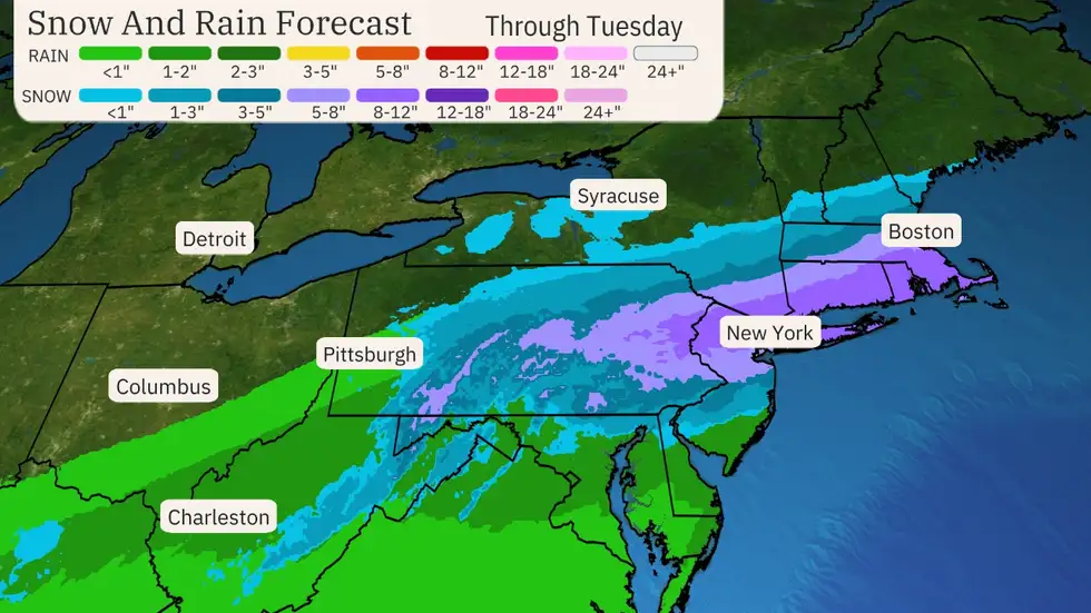
Details: Every 0Z model (GFS, Euro, CMC, UK, NAM, RGEM, HRRR) is showing at least 6" of 10:1 ratio snow along and N of 78 in PA/NJ/NYC and at least 3" along 276/195. Also, several of the models have that 6" line as far south as 276/195 in PA/NJ (or even past Philly on the Euro) and those models (Euro/GFS/HRRR/CMC) all have 6" along 195/276 increasing to 10" or so as one moves up to 78. Even if one cuts those snowfall totals by 1/4 due to ratios/melting (i.e., a 7.5:1 ratio), that's still 4.5" along 195/276 and up to 7.5" along 78 for the snowier models and at least 2" along 195/276 and at least 4.5" along 78 for the somewhat less snowy models.

Yes, it's possible the forecast could trend back to the north some, but no experts I've read at AmericanWx or Twitter or elsewhere expects a shift as large as what we saw today to be realistic, as the error bars on forecasts continuously shrink as one gets near the event and we're only ~24 hours before the event starts (as rain), meaning the current NWS forecast is almost impossible to defend at this point, i.e., <1" of snow south of 78. It's also worth noting that their discussion says, "From there, latest model guidance has the low just a bit farther north from previous runs." which is completely wrong as the low has been shifting south since the 12Z runs at noon and they know that.

The rest of the 18Z models and all of the 0Z models moved the low further south for very good synoptic reasons (convective interference going on in the SE US). That combined with the storm being forecast to strengthen quickly along the baroclinic zone as it travels just off the coast, leading to development of a well modeled cold conveyor belt, which will dynamically cool the column due to the strong lift of moist air into the cold air in the DGZ (dendritic growth zone around 15K feet up), will change the rain over to heavy snowfall for most of us from about 5 am to noon on Tuesday (1-2" per/hr rates likely), which will quickly start to accumulate at those rates, despite 33-35F surface temps. And with good growth and once the accumulation starts, most experts I've seen are talking about snow accumulation ratios in the 7-9:1 region (even if Kuchera says lower).

See the AmericanWx link for details and John Homenuk's Twitter page for some of the best insights around. He's similarly bullish on this storm, predicting 2-4" for NYC metro and more N/W and discusses how the models are showing a lot more and that that might be what we see even south of 78.

https://www.americanwx.com/bb/topic/60026-significant-winter-storm-rain-snow-mix-on-feb-13/page/38/

https://twitter.com/jhomenuk
So, NWS-Philly issued warnings for Poconos/Sussex for 9-12" of snow, for the Lehigh Valley, Morris, Warren for 7-10" of snow and for Berks, NW Bucks, Hunterdon and Somerset for 4-7" of snow. However, they inexplicably left Middlesex out of the warning (or at least the northern half, which will likely do as well as southern Somerset/Hunterdon), putting Middlesex, Mercer, Lower Bucks and Montco (but no Monmouth) under advisories for 2-4" of snow. These are all fairly close to what I was thinking above.

Also, the NWS-NYC issued watches for Union/Essex/Hudson and NYC/LI for 5-8" and warnings for everywhere north of there for 7-10" of snow, which makes sense to me, even if those amounts are a little bit higher than I expected (I don't like to guess too high and felt I was already out on a limb predicting much more snow than they were) - they are in line with what models are showing.

NWS-Philly just updated their map below as did NWS-NYC...

Also, revising my initial guess of 2" for my house from Saturday night to 7.2" as my final prediction for my house (usually make these ~24 hrs before the snow starts).

DtNgSMt.png


cxHceB8.png
 
Last edited:
  • Like
Reactions: Morrischiano
Potential for up to a foot for all of EPA/CNJ/NNJ/NYC/SENY/LI exists and even 8"+ is possible for Philly/nearby SNJ, as per last night's 1Euro, HRRR and today's 6Z NAM and GFS. That's not a forecast, but sharing the upside.
 
As of 5:13 a.m., the National Weather Service says in its forecast discussion:

"Farther south and east, low-level temperatures will be more in the mid-30s with stronger
forcing not co- located with the dendritic growth region. However, given the rather dynamic situation with strong frontogenetic forcing, there may be a brief window for heavy snow even close to I-95 around the later part of the morning commute that will bear watching. Again though, that looks like it will struggle to amount to more than a slushy inch or two.That part of the forecast may need to be adjusted by later shifts, though."

In other words, the forecast isn't terrible for those of us in Philly and South Jersey , but we should keep out a watchful eye.
 
DtNgSMt.png


I could live with this. And if true, my prediction would be correct…snow but not enough to use the snowblower.
 
As of 5:13 a.m., the National Weather Service says in its forecast discussion:

"Farther south and east, low-level temperatures will be more in the mid-30s with stronger
forcing not co- located with the dendritic growth region. However, given the rather dynamic situation with strong frontogenetic forcing, there may be a brief window for heavy snow even close to I-95 around the later part of the morning commute that will bear watching. Again though, that looks like it will struggle to amount to more than a slushy inch or two.That part of the forecast may need to be adjusted by later shifts, though."

In other words, the forecast isn't terrible for those of us in Philly and South Jersey , but we should keep out a watchful eye.
NWS-Philly has been awful so far on this storm and I truly hate to say that, as I think they usually do great work and I don't like slamming them, but it is what it is. And I still think their forecast is well underdone along/south of 276/195. TWC and many others are predicting 2-4" for Philly Metro (which includes Cherry Hill) and I think that's a good call, not the 1" or so from the NWS (and <1" for Cherry Hill). Sure, 1" or so is possible, but so is 3-6" for Philly depending on how this system performs (there are several models showing that).
 
Is it possible the storm continues trending south and keeps the heaviest snow to the south of us? Interesting scenario this mornings euro run may have hinted at.
 
As the WPC said in their discussions there could be more changes in the model runs today
So as we currently sit, Trenton is going to be 2” or so correct? Working overnight again so driving at those times is going to be rough I assume.
 
Is it possible the storm continues trending south and keeps the heaviest snow to the south of us? Interesting scenario this mornings euro run may have hinted at.
We're now so close to the event that major shifts in track are unlikely. Can't say it's impossible, though, as it's the friggin' weather lol. I'd say if the 12Z models today, which initialize at 7 am EST, about 12-14 hours before the precip starts, don't show any significant shift, then we're not going to see one after that.

And the first two 12Z models just came out and they're doozies, as the HRRR and NAM both slam the whole region. The HRRR has 8-12" of snow down to 195/276 and even hits Philly/SNJ with 3-6" of snow (the 3" line is from about Chester to Toms River and the 6" line is from about Philly to Pt. Pleasant), while the 12Z NAM has 8-12" for most of CNJ (less towards the coast), with a 3" line from Philly to Toms River and the 6" line from about Bordentown to Highlands. So the fact that their tracks and intensities didn't change makes it a bit less likely we're going to see some drastic change in the other models.

IMO, the biggest risk to getting major snowfall (8" or more) for CNJ and the larger region is some sort of change in the dynamics of how the streams interact with the low as it heads from the TN Valley across to the DelMarVa coast and towards the 40/70 benchmark, which could reduce total precip/snow, as we've seen on a few model runs (like the UK last night where only 0.8-1.2" of precip fell with 4-8" of snow generally for CNJ/NNJ).
 
So as we currently sit, Trenton is going to be 2” or so correct? Working overnight again so driving at those times is going to be rough I assume.
Same thing I said above, i.e., I'd guess 3-6" for Trenton (in the 2-3" swath right now by the NWS, which I think is still low) with potential for more.
 
  • Like
Reactions: RutgersK1d
You guys think flights will be getting into Newark at around 5pm on Tuesday? We're due to land a little after 5pm, then have a drive from the airport home on turnpike south/parkway.

Think we'll make it, or still a mess at that time?
 
  • Haha
Reactions: RUScrew85
We're now so close to the event that major shifts in track are unlikely. Can't say it's impossible, though, as it's the friggin' weather lol. I'd say if the 12Z models today, which initialize at 7 am EST, about 12-14 hours before the precip starts, don't show any significant shift, then we're not going to see one after that.

And the first two 12Z models just came out and they're doozies, as the HRRR and NAM both slam the whole region. The HRRR has 8-12" of snow down to 195/276 and even hits Philly/SNJ with 3-6" of snow (the 3" line is from about Chester to Toms River and the 6" line is from about Philly to Pt. Pleasant), while the 12Z NAM has 8-12" for most of CNJ (less towards the coast), with a 3" line from Philly to Toms River and the 6" line from about Bordentown to Highlands. So the fact that their tracks and intensities didn't change makes it a bit less likely we're going to see some drastic change in the other models.

IMO, the biggest risk to getting major snowfall (8" or more) for CNJ and the larger region is some sort of change in the dynamics of how the streams interact with the low as it heads from the TN Valley across to the DelMarVa coast and towards the 40/70 benchmark, which could reduce total precip/snow, as we've seen on a few model runs (like the UK last night where only 0.8-1.2" of precip fell with 4-8" of snow generally for CNJ/NNJ).

That thought came from WPC so yes shifts can happen
 
See my reply to Tango about ratios. I would also use about 5-7:1 along 95 and SE, but closer to 10:1 along 78 and north. Also some models are just running colder, like the NAM, where the 10:1 maps are fine. I also think ratios up in the column may actually be quite good once we get the cold conveyor belt cranking with good growth in the DGZ, even along 95, but melting will also be an issue until accumulations start with higher intensity snow. Makes it so tough to know how much snow folks will get on roads vs. yards which will greatly depend on where they are.

I also noted that issue yesterday when they the watches were issued for Hunterdon>Berks/NW Bucks, which they shouldn't have been IMO, too. Mt. Holly has just seemed off its game the past year or two and I don't know why (Walt Drag's retirement maybe).
I agree, and Walt is the man. Always enjoy his posts on americanwx.

Some positive overnight developments on the axis of precip for snow lovers.
 
  • Like
Reactions: RU848789
We're now so close to the event that major shifts in track are unlikely. Can't say it's impossible, though, as it's the friggin' weather lol. I'd say if the 12Z models today, which initialize at 7 am EST, about 12-14 hours before the precip starts, don't show any significant shift, then we're not going to see one after that.

And the first two 12Z models just came out and they're doozies, as the HRRR and NAM both slam the whole region. The HRRR has 8-12" of snow down to 195/276 and even hits Philly/SNJ with 3-6" of snow (the 3" line is from about Chester to Toms River and the 6" line is from about Philly to Pt. Pleasant), while the 12Z NAM has 8-12" for most of CNJ (less towards the coast), with a 3" line from Philly to Toms River and the 6" line from about Bordentown to Highlands. So the fact that their tracks and intensities didn't change makes it a bit less likely we're going to see some drastic change in the other models.

IMO, the biggest risk to getting major snowfall (8" or more) for CNJ and the larger region is some sort of change in the dynamics of how the streams interact with the low as it heads from the TN Valley across to the DelMarVa coast and towards the 40/70 benchmark, which could reduce total precip/snow, as we've seen on a few model runs (like the UK last night where only 0.8-1.2" of precip fell with 4-8" of snow generally for CNJ/NNJ).
the nam kuchera clown maps are not 8-12 and cut amounts from their 6z run to their 12z run

snku_acc-imp.us_ne.png


snku_acc-imp.us_ne.png
 
As per the NWS you're in the 2-3" swath and I'm sure you've seen most of the models showing 3-6" for your area (and a few showing close to a foot), so you should still be in the game for a decent snowfall.
I haven't been following the model runs for this one. Seen too many busts to not get excited. I'm just along for the ride on this one, and Mt Holly is my ride or die. Methinks they've been overhyping prior storms so they are playing this one closer to the vest.
 
I haven't been following the model runs for this one. Seen too many busts to not get excited. I'm just along for the ride on this one, and Mt Holly is my ride or die. Methinks they've been overhyping prior storms so they are playing this one closer to the vest.
I think Mt Holly is not rushing from run to run. Good approach by them and not sure why Numbers is criticizing them. We have had a shift in the models where snow accumulations seem more likely. Yet its really on the HRRR going insane with the amounts across the entire region. Mt Holly did raise amounts a good deal over the northern parts but are cautions from 1 95 south because temps still are going to be marginal. They have all afternoon to shift Trenton into the 3-5 ish range if warranted.

again the snow will be on the wetter side..you might measure 6 inches on the snowboard but only see 4 on the pavement that will be the slushier and heavier variety. This is the type of snow that gives heart attacks as it will be very heavy
 
  • Like
Reactions: T2Kplus20
I think Mt Holly is not rushing from run to run. Good approach by them and not sure why Numbers is criticizing them. We have had a shift in the models where snow accumulations seem more likely. Yet its really on the HRRR going insane with the amounts across the entire region. Mt Holly did raise amounts a good deal over the northern parts but are cautions from 1 95 south because temps still are going to be marginal. They have all afternoon to shift Trenton into the 3-5 ish range if warranted.

again the snow will be on the wetter side..you might measure 6 inches on the snowboard but only see 4 on the pavement that will be the slushier and heavier variety. This is the type of snow that gives heart attacks as it will be very heavy
He is criticizing them because he wants everyone to maximize wishcasting. Been a long, long time since a real snowstorm hit the area.
 
That thought came from WPC so yes shifts can happen
Yes, I read the WPC discussion and they're not talking about track shifts as large as what we saw yesterday, but even a 30 mile track shift could make a major difference for locations on the fringe of getting a lot vs. a little snow, like areas SE of 95 right now and down to 195. Again the bigger risk is changing storm dynamics/intensity of snowfall which could have a major impact on melting and accumulation, so the major snows (8" or more) for south of 78 and the 95 corridor north of 195 are on the table, but not a lock yet (I think they are a lock for along/N of 78).
 
I think Mt Holly is not rushing from run to run. Good approach by them and not sure why Numbers is criticizing them. We have had a shift in the models where snow accumulations seem more likely. Yet its really on the HRRR going insane with the amounts across the entire region. Mt Holly did raise amounts a good deal over the northern parts but are cautions from 1 95 south because temps still are going to be marginal. They have all afternoon to shift Trenton into the 3-5 ish range if warranted.

again the snow will be on the wetter side..you might measure 6 inches on the snowboard but only see 4 on the pavement that will be the slushier and heavier variety. This is the type of snow that gives heart attacks as it will be very heavy
The NWS was being lambasted by most of the red taggers yesterday/last night, especially on the Discord. Their slowness to make the changes they made at 4 am was indefensible really. Their forecast now is decent, but probably still on the low side (but no longer terrible).
 
Should I toss down some salt tonight on the driveway?
Or wait until the morning after the first shovel?
 
Dan Zarrow


attachment-Back-to-Winter-20240212.jpg
Decent forecast, but likely low for 95 and towards 195/coast IMO. I think TWC forecast is better, although it could be a bit overdone - a blend of the two would probably be great. TWC 3" line is about Philly to Pt. Pleasant, their 5" line is basically 276/195 and their 8" line is just about along 78 and I think those are pretty good, but if things change, they could be too high.

akX9cDY.png


even MT Holly thinks their 4-7 in somerset puts the higher amounts in the northern sections...I think caution is the word of advice. Going to be difficult to see 3-5 inches at the coast with temps 34 degrees

Zarrow and others are taking a happy medium using their knowledge rather than just taking 10-1 snow maps of the snowier models verbatim...there is going to be issues with this system
 
Interesting side note for this storm is that the special election to fill George Santos's congressional seat is tomorrow on Long Island.
 
The poor snowblower has not gotten any use in 3 winters.
IDK if @koleszar will ever get his new snowblower out of the box, but the box apparently makes a great work table. My snowblower has become a great tool rack in the garage.
I did get it out of the box during the last potential storm and put it together. But by time I woke up the snow had compacted from 4" to 2" so never used it. I didn't put any gas in it yet as I figured I'll just wait and see what happens.

Just my luck I have 3 trucks of concrete ordered for tomorrow and couldn't get an inspection any earlier today to pour. I'd hate to have my guys pouring in 33 degree rain, I don't need anyone getting sick. I'll probably scrap the whole thing till later in the week.
 
ADVERTISEMENT
ADVERTISEMENT