Yup, that’s the important thing. You get over freezing the next day, you avoid the freeze over issues.Yeah i mean overnight it freezes but its not a deep freeze coming...and for that matter all the talk about dramatic pattern change isnt really happening. Sure dramatic compared to plus 15 60 degree highs but upper 30s to low 40s in mid February isnt that bad


Colleges
- American Athletic
- Atlantic Coast
- Big 12
- Big East
- Big Ten
- Colonial
- Conference USA
- Independents (FBS)
- Junior College
- Mountain West
- Northeast
- Pac-12
- Patriot League
- Pioneer League
- Southeastern
- Sun Belt
- Army
- Charlotte
- East Carolina
- Florida Atlantic
- Memphis
- Navy
- North Texas
- Rice
- South Florida
- Temple
- Tulane
- Tulsa
- UAB
- UTSA
- Boston College
- California
- Clemson
- Duke
- Florida State
- Georgia Tech
- Louisville
- Miami (FL)
- North Carolina
- North Carolina State
- Pittsburgh
- Southern Methodist
- Stanford
- Syracuse
- Virginia
- Virginia Tech
- Wake Forest
- Arizona
- Arizona State
- Baylor
- Brigham Young
- Cincinnati
- Colorado
- Houston
- Iowa State
- Kansas
- Kansas State
- Oklahoma State
- TCU
- Texas Tech
- UCF
- Utah
- West Virginia
- Illinois
- Indiana
- Iowa
- Maryland
- Michigan
- Michigan State
- Minnesota
- Nebraska
- Northwestern
- Ohio State
- Oregon
- Penn State
- Purdue
- Rutgers
- UCLA
- USC
- Washington
- Wisconsin
High School
- Illinois HS Sports
- Indiana HS Sports
- Iowa HS Sports
- Kansas HS Sports
- Michigan HS Sports
- Minnesota HS Sports
- Missouri HS Sports
- Nebraska HS Sports
- Oklahoma HS Sports
- Texas HS Hoops
- Texas HS Sports
- Wisconsin HS Sports
- Cincinnati HS Sports
- Delaware
- Maryland HS Sports
- New Jersey HS Hoops
- New Jersey HS Sports
- NYC HS Hoops
- Ohio HS Sports
- Pennsylvania HS Sports
- Virginia HS Sports
- West Virginia HS Sports
ADVERTISEMENT
Install the app
How to install the app on iOS
Follow along with the video below to see how to install our site as a web app on your home screen.
Note: This feature may not be available in some browsers.
You are using an out of date browser. It may not display this or other websites correctly.
You should upgrade or use an alternative browser.
You should upgrade or use an alternative browser.
OT: Significant (CNJ) to Major (Along/N of 78) Winter Storm Likely on Tuesday (2/12-13; much less uncertainty on outcome)
- Thread starter RU848789
- Start date
Monmouth Ocean/County Border near the beaches should be fine, correct?Yeah i mean overnight it freezes but its not a deep freeze coming...and for that matter all the talk about dramatic pattern change isnt really happening. Sure dramatic compared to plus 15 60 degree highs but upper 30s to low 40s in mid February isnt that bad
You probably will have no worries with that. My sister lives in Lake Como and I’m always envious of her tales of all rain or nothing on cars in the morning!Monmouth Ocean/County Border near the beaches should be fine, correct?
No kidding! Love Lake Como. We lived on 20th Ave between Surf and A, and then on Snyder close to 18th, and on 19th a few houses East of the Lake Como border. Great area, and some of the nicest beaches at the very end of Belmar on 20th Ave.You probably will have no worries with that. My sister lives in Lake Como and I’m always envious of her tales of all rain or nothing on cars in the morning!

Yup! It’s nice to visit there even during the offseason. I can see why people want to live in that area permanently.No kidding! Love Lake Como. We lived on 20th Ave between Surf and A, and then on Snyder close to 18th, and on 19th a few houses East of the Lake Como border. Great area, and some of the nicest beaches at the very end of Belmar on 20th Ave.
Euro way south too..wow.
Wouldn’t get too caught up in the amounts these models are spitting out…more interested in the trends.
A more south storm will mean more snow…and the 18z models trended south.
We already covered this earlier.

@knightfan7 , @koleszar , @e5fdny and others in "south central" jersey, this could be a worse case scenario for us.Euro way south too..wow.
Wouldn’t get too caught up in the amounts these models are spitting out…more interested in the trends.
A more south storm will mean more snow…and the 18z models trended south.
At a SB party but had to check... nice summary of the 18z models shifting south and snowy... buckle up if we get anything like this even down to 195 and the coast...
At a SB party but had to check... nice summary of the 18z models shifting south and snowy... buckle up if we get anything like this even down to 195 and the coast...
We are in CT sport
Why would anyone care if ur in CT?We are in CT sport
D'oh... that's why I hate posting from my phone... only saw the first 2 which show nj.You posted a map of Ct
OMG he's a drunk that can't read maps now lolYou posted a map of Ct
Nice catchYou posted a map of Ct
You can have all of the snow on my driveway for free.I'll take some monmouth snow for once
Pisco sours ftw!OMG he's a drunk that can't read maps now lol
Definitely trending snowier. Won’t be surprised to see winter Storm watches tomorrow for much of north or central nj,
Latest NAM is a crush job.
Latest NAM is a crush job.
Definitely trending snowier. Won’t be surprised to see winter Storm watches tomorrow for much of north or central nj,
Latest NAM is a crush job.
Why the laughing emoji? Disagree, Bac?
I BOUGHT a cover for my Toro snowblower.
No guarantee of no snow but feel confident I won’t need it.
Bad.
Jeff Smith 2-4 plus our area as colder and snowier scenarios are looming
Jeff Smith 2-4 plus our area as colder and snowier scenarios are looming
For what it's worth, Latest (10PM) NWS forecast for us removed any mention of snow. Around 39-41 overnight with 1.5 or more inches of rain mostly from Mon night to early Tue aftHe's in a CT state of mind.
My better half was parked in the garage on the snowblower electric start cord. We moved the car and the cord, because, I said, it would be terrible to be snowed in and not be able to get the snowblower started to clear the snow. Heh, heh, we did our part.I BOUGHT a cover for my Toro snowblower.
No guarantee of no snow but feel confident I won’t need it.
Yeah, liking it. I think we can bank on that I won't be headed East down Main Street with my snowblower to clear your driveway.For what it's worth, Latest (10PM) NWS forecast for us removed any mention of snow. Around 39-41 overnight with 1.5 or more inches of rain mostly from Mon night to early Tue aft
It's going to be 50 degrees tomorrow.Jeff Smith 2-4 plus our area as colder and snowier scenarios are looming
My better half was parked in the garage on the snowblower electric start cord. We moved the car and the cord, because, I said, it would be terrible to be snowed in and not be able to get the snowblower started to clear the snow. Heh, heh, we did our part.
Yeah, liking it. I think we can bank on that I won't be headed East down Main Street with my snowblower to clear your driveway
Ha! It's the thought that counts
The poor snowblower has not gotten any use in 3 winters.Ha! It's the thought that counts
IDK if @koleszar will ever get his new snowblower out of the box, but the box apparently makes a great work table. My snowblower has become a great tool rack in the garage.
A question that I hope is not too far off the track: are there good battery-powered snowblowers? I have had a gas-powered snowblower and disliked it, particularly the difficulty of keeping gasoline alive from one season to another.
Do you have a large driveway and walkway to clear? If not, a battery powered one may be fine. I don't have any brand recommendation, because I have stuck with gasoline. I drain the gas tank at the end of each season and run the engine until all the fuel is expended, and that has worked well.A question that I hope is not too far off the track: are there good battery-powered snowblowers? I have had a gas-powered snowblower and disliked it, particularly the difficulty of keeping gasoline alive from one season to another.
I have a pretty large driveway (a two-car driveway with a turn into the garage), but the walkways aren't hugely long. Could I cope by simply having a second battery to put in when the first was exhausted? Or is a battery-powered snowblower just not suited for a large area? BTW, would a snowblower be able to go up a step without breaking my back? Otherwise, i would still have to shovel the front walkway.Do you have a large driveway and walkway to clear? If not, a battery powered one may be fine. I don't have any brand recommendation, because I have stuck with gasoline. I drain the gas tank at the end of each season and run the engine until all the fuel is expended, and that has worked well.
Yes. In fact, EGO Power sells their snowblowers with 2 batteries. I have been very pleased with their battery weed trimmer, multi-tool (hedge trimmer, small tiller, pole chain saw). The batteries still work after 5 years, and we have 3 or 4 batteries with 2 chargers. If I am using the weed trimmer for a while, and I run out of battery, I change out the battery. EGO Power snowblowers are sold at Lowes and ACE Hardware. I think they are the same price at every store, but I would check that. A benefit of a local ACE Hardware is they will generally deliver heavier items to you assembled at a modest charge, if you have a good local ACE Hardware. We do. Here's a link:I have a pretty large driveway (a two-car driveway with a turn into the garage), but the walkways aren't hugely long. Could I cope by simply having a second battery to put in when the first was exhausted? Or is a battery-powered snowblower just not suited for a large area? BTW, would a snowblower be able to go up a step without breaking my back? Otherwise, i would still have to shovel the front walkway.
Power Through Winter | EGO
Get power that exceeds gas plus industry-leading innovations. Compare EGO snow blowers to find the right one for you this season.
Don't think it is a good idea to take a snowblower up a step. The auger (the mechanical blade that "throws" the snow up the chute) might hit the edge of the step.
Summary: It's game on for a significant to major snowstorm for most of the area, even down to 276/195 and maybe even Philly/adjacent SNJ. The 18Z and 0Z models continue to show the storm being further south meaning less warm air drawn in due to the track and a faster changeover to heavy snow as the storm is modeled to have high precip rates. I think it's reasonable to expect 5-6" or more along/N of 78 with up to 10-12" as one heads towards 80/84 in PA/NJ and north of 287 in SENY and that it's reasonable to expect 2-3" along 276/195 meaning nearly all of CNJ, including 95 from Trenton to NYC would likely be between 2-6" (from south to north), with the potential for that to be more like 4-8" from 195 to 78. And even Philly/nearby SNJ could be in the 1-3" range.So, things are really starting to get spicy. The 18Z NAM and RGEM both went further south and significantly snowier for areas south of 78. The NAM now showing 6"+ between 276/195 and 78 (at 10:1, but it's cold, so ratios probably not far below 10:1) even down to Toms River (not sure I buy that) and the RGEM showing a 6" line (at 10:1 ratios - it's a 4" line on Kuchera) from about Doylestown to South Amboy with more north of that line, but a 1" line from Philly to AP, so the gradient is very steep. And if you want to see a weenie map, go look at the 18Z HRRR (over 12" from New Hope to Sayrevill and N of there), which is way out of its range.
The point is that this is, so far, continuing the southward/snowier shift we saw at 12Z, but we need to see the global models confirm this before having confidence in 6" amounts for much of CNJ. And the 18Z GFS just came close with the 6" line from about New Hope to JFK. But the NWS hadn't seen any of this when they put their new map together, which decreases snowfall south of 78, so will be interesting to see if they update that map later tonight.
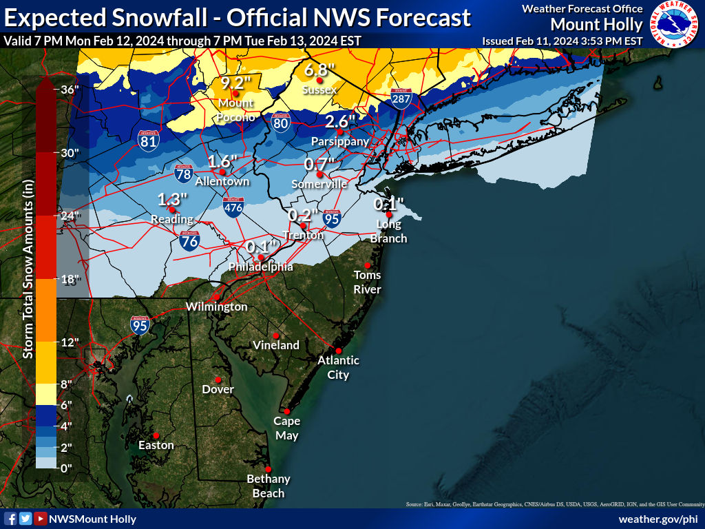
Also, the worst of this will hit CNJ with heavy snow from about 5 am through noon or so, meaning the morning rush hour will likely be a mess, even if treated roads keep accumulations down, as visibility is absolutely going to be an issue - and areas that see the heaviest 2"/hr bands will see accumulations even on treated roads (and local roads will likely see accumulations assuming everyone gets the 1"/hr rates being shown on all of the models. The chances of this being only a sloppy inch or so for areas south of 78 (the NWS forecast) are now quite low, but the amounts I mentioned above could certainly be what we're seeing in the less snowy models, i.e., I think 2-4" between 195 and 78 is likely now the "floor" for this event (if 7.5:1 ratios and the less snowy models verify, as per the details below). This is probably the hardest I've disagreed with the NWS ever (or at least since Nov-18, which was somewhat similar with mostly rain predicted until 6 hours before the event, but everyone in CNJ getting 4-8" and a nightmare on the roads as the snow hit around noon, like a wall.
I'd guess that the NWS-Philly will upgrade snowfall amounts at 4 am and go with advisories for 2-5" for most of CNJ (Hunterdon/Somerset/Middlesex/Mercer/Monmouth) and for Bucks, Montco, Berks and maybe W. Chester and warnings for 6" or more for all of the counties north of 78 in PA/NJ (Poconos/Lehigh Valley and Sussex/Morris/Warren) and that the NWS-NYC will also go with advisories for 2-5" for Union/Essex/Hudson, NYC/LI and probably warnings for 6" or more for Passaic/Bergen and SE NY north of the Bronx.
Don't want to forget that minor to moderate coastal flooding is likely for DE/NJ/NY coasts on Tuesday and 40-45 mph winds are likely for coastal areas and 30-35 mph inland as the storm cranks on Tuesday.
Details: Every 0Z model (GFS, Euro, CMC, UK, NAM, RGEM, HRRR) is showing at least 6" of 10:1 ratio snow along and N of 78 in PA/NJ/NYC and at least 3" along 276/195. Also, several of the models have that 6" line as far south as 276/195 in PA/NJ (or even past Philly on the Euro) and those models (Euro/GFS/HRRR/CMC) all have 6" along 195/276 increasing to 10" or so as one moves up to 78. Even if one cuts those snowfall totals by 1/4 due to ratios/melting (i.e., a 7.5:1 ratio), that's still 4.5" along 195/276 and up to 7.5" along 78 for the snowier models and at least 2" along 195/276 and at least 4.5" along 78 for the somewhat less snowy models.
Yes, it's possible the forecast could trend back to the north some, but no experts I've read at AmericanWx or Twitter or elsewhere expects a shift as large as what we saw today to be realistic, as the error bars on forecasts continuously shrink as one gets near the event and we're only ~24 hours before the event starts (as rain), meaning the current NWS forecast is almost impossible to defend at this point, i.e., <1" of snow south of 78. It's also worth noting that their discussion says, "From there, latest model guidance has the low just a bit farther north from previous runs." which is completely wrong as the low has been shifting south since the 12Z runs at noon and they know that.
The rest of the 18Z models and all of the 0Z models moved the low further south for very good synoptic reasons (convective interference going on in the SE US). That combined with the storm being forecast to strengthen quickly along the baroclinic zone as it travels just off the coast, leading to development of a well modeled cold conveyor belt, which will dynamically cool the column due to the strong lift of moist air into the cold air in the DGZ (dendritic growth zone around 15K feet up), will change the rain over to heavy snowfall for most of us from about 5 am to noon on Tuesday (1-2" per/hr rates likely), which will quickly start to accumulate at those rates, despite 33-35F surface temps. And with good growth and once the accumulation starts, most experts I've seen are talking about snow accumulation ratios in the 7-9:1 region (even if Kuchera says lower).
See the AmericanWx link for details and John Homenuk's Twitter page for some of the best insights around. He's similarly bullish on this storm, predicting 2-4" for NYC metro and more N/W and discusses how the models are showing a lot more and that that might be what we see even south of 78.
https://www.americanwx.com/bb/topic/60026-significant-winter-storm-rain-snow-mix-on-feb-13/page/38/
https://twitter.com/jhomenuk
Note: I posted all of the relevant model snowfall maps from tonight's 0Z suite to this post on AmericanWx in case folks want to peruse them. Posting graphics here is a PITA and figured they're more appropriate there, anyway. It's pretty impressive how much better they're all aligned than they have been before now. Hopefully, we won't have any more wild model swings, but I can't say that's never happened before within 24 hours of the start of an event, so stay tuned.
On that note, the 6Z NAM is the snowiest it has been (like the 0Z Euro) with 6" from Wilmington to Toms River and 11-12" from Philly to NYC and the whole 95 corridor, as that is where the best banding was. So Philly/SNJ are now in play for 6" or more of snow. This is getting crazy.
https://www.americanwx.com/bb/topic...mix-on-feb-13/?do=findComment&comment=7209760
Similar threads
- Replies
- 62
- Views
- 2K
OT: Minor to Moderate (2-4?) Snowfall Likely Sat morning (2/17); will be <32F, so expect slick roads
- Replies
- 213
- Views
- 5K
- Replies
- 477
- Views
- 12K
- Replies
- 592
- Views
- 16K
- Replies
- 771
- Views
- 20K
ADVERTISEMENT
Latest posts
-
 BB Recruiting 2024 former SEC commit big man visiting this weekend
- Latest: NewJerseyHawk
-
-
ADVERTISEMENT