I thought the brothers rac were out of this thread?
Anyways, how about some deli pics?
All rain here in Wall. Heavy rain.
I'll chime in as I like to troll #'s. Bac is officially out.


Follow along with the video below to see how to install our site as a web app on your home screen.
Note: This feature may not be available in some browsers.
I thought the brothers rac were out of this thread?
Anyways, how about some deli pics?
All rain here in Wall. Heavy rain.
You guys working?I'll chime in as I like to troll #'s. Bac is officially out.
You guys working?
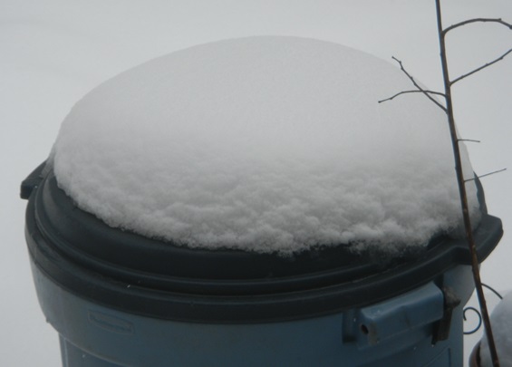
Intensity definitely let up some the last hour. Have 3.5" as of 5 am - could also have been some compaction, as this is heavy, wet snow (maybe 8:1 ratio if I had to guess). One more good band to rotate through, so maybe we get to 4" . Still 31F.3.25" as of 4:00 am, so 1" per hour rates the last 30 minutes, as the intensity has let up some; still snowing moderately, but it's starting to look like the back edge of the heavier precip may only be 1-2 hours away. 4-5" is looking likely.
I thought the brothers rac were out of this thread?
Anyways, how about some deli pics?
All rain here in Wall. Heavy rain.
No snow? I'm in Essex Co we got maybe 3 inches. It's still snowing..:grimace:This, in the 2-6 as well. No snow.
No snow? I'm in Essex Co we got maybe 3 inches. It's still snowing..:grimace:
Intensity definitely let up some the last hour. Have 3.5" as of 5 am - could also have been some compaction, as this is heavy, wet snow (maybe 8:1 ratio if I had to guess). One more good band to rotate through, so maybe we get to 4" . Still 31F.
No snow. All rain, all night. Works for me.
Had about a 90 minute nap. And will likely repeat all this Sunday night, although I think that snow will be over before 4-5 am...Have you slept at all since last night?
Nice - Central Park just reported 4". I used to love when our son was young and we'd go sledding every storm. Our favorite place, once he got older, was Schooley Mountain in Long Valley - amazing place with a 200 foot vertical for sledding - place would always be packed with kids and MILFs, lol...We have a pretty good amount of snow on the ground here in Manhattan. Taking the kids to the park to go sledding right now.
Not even any sleet? Was it freezing rain at all or did you stay above 32F. Reports were that it was all sleet south of the Raritan probably down to close to you...
As I said earlier, in Monroe nothing on the ground. Just a slight touch of slush on my windshield. Every time I looked outside overnight, it was plain rain.Not even any sleet? Was it freezing rain at all or did you stay above 32F. Reports were that it was all sleet south of the Raritan probably down to close to you...
Probably not, and all for a measly inch or so. It's been a rough winter for snow lovers. Not much of anything here.....no shoveling, no plowing.Have you slept at all since last night?
+1I didn't stay up to watch. The trace evidence that exists would suggest no frozen precip of any kind. Radar echos were showing us above the snow line for most of the night but temps must have been +32, because it was liquid by the time it hit the ground.
Interesting that the Sunday night event is, for now, watch criteria as opposed to warning. Mt. Holly is saying 4-8 N&W of the corridor, with sharp drop-offs below.
4.25". Suck it.Probably not, and all for a measly inch or so. It's been a rough winter for snow lovers. Not much of anything here.....no shoveling, no plowing.
I didn't stay up to watch. The trace evidence that exists would suggest no frozen precip of any kind. Radar echos were showing us above the snow line for most of the night but temps must have been +32, because it was liquid by the time it hit the ground.
Interesting that the Sunday night event is, for now, watch criteria as opposed to warning. Mt. Holly is saying 4-8 N&W of the corridor, with sharp drop-offs below.
I'm sure the "trained spotter" in Metuchen is juicing those numbers, he always does so.4.25". Suck it.
Interesting, would've thought you'd at least get some sleet. They're at watches instead of warnings, due to timing - typically they go to warnings when the event is "imminent" (typically, will be starting within 24 hours - so expect warnings and advisories with the 4 pm package). This one has definitely trended SE, which means you guys might get a few to several inches of snow with some rain too, when it looked like all mostly/all rain even just a day ago.
Just went outside. It's actually ice on the windshield. Must have been a little sleet or freezing rain here.As I said earlier, in Monroe nothing on the ground. Just a slight touch of slush on my windshield. Every time I looked outside overnight, it was plain rain.
I have an 0845 flight out of EWR on Monday, so I'm not really interested in getting any snow.
Looks like a bit over 2 in Hillsborough. Heading over to the Hillsborough Deli soon to pickup some coffee.
Hey, I know you're a pilot and up on all kinds of aviation stuff - did you hear about the two SW Airlines planes colliding while taxiing on the runway at EWR a little while ago? Heard they now have a ground stop there.I have an 0845 flight out of EWR on Monday, so I'm not really interested in getting any snow.
After a little nap, just shoveled during the last throes of the storm, which was nice. Final tally (still snowing lightly, but doubt we'll get much more) was 4.25" here in Metuchen vs. my 1-3" forecast with no advisory - big difference north of the Raritan vs. south of the Raritan, where it sounds like it was mostly/all sleet. 31F still.
This brings me to 18" for the season and with another 6" tomorrow, I'd be up around 24", which isn't far from our 28" normal. Could still make it with one more snowfall...
Hey, I know you're a pilot and up on all kinds of aviation stuff - did you hear about the two SW Airlines planes colliding while taxiing on the runway at EWR a little while ago? Heard they now have a ground stop there.
https://www.mirror.co.uk/news/us-news/breaking-newark-airport-two-southwest-14076385
Really? Here in Monmouth county I think we've only had about 3" total. It's been a real good winter. I'll be buying a snow blower the end of this winter at a real low, low price. Using the front loader to clear out our barns is just overkill and tears the pastures up too much..
This brings me to 18" for the season and with another 6" tomorrow, I'd be up around 24", which isn't far from our 28" normal. Could still make it with one more snowfall...

Just rain here, perhaps the change over at 6pm'ish?Started light rain with some flurries mixed in here in Linden