Ah, never mind. I have a Canadian client called Loblaw that brings in major revenue, which also qualifies them to commit almost daily stupid client tricks. Was curious if you were associated with them.What is this double talk? Clearly you've never read my law blog


Colleges
- AAC
- ACC
- Big 12
- Big East
- Big Ten
- Pac-12
- SEC
- Atlantic 10
- Conference USA
- Independents
- Junior College
- Mountain West
- Sun Belt
- MAC
- More
- Navy
- UAB
- Tulsa
- UTSA
- Charlotte
- Florida Atlantic
- Temple
- Rice
- East Carolina
- USF
- SMU
- North Texas
- Tulane
- Memphis
- Miami
- Louisville
- Virginia
- Syracuse
- Wake Forest
- Duke
- Boston College
- Virginia Tech
- Georgia Tech
- Pittsburgh
- North Carolina
- North Carolina State
- Clemson
- Florida State
- Cincinnati
- BYU
- Houston
- Iowa State
- Kansas State
- Kansas
- Texas
- Oklahoma State
- TCU
- Texas Tech
- Baylor
- Oklahoma
- UCF
- West Virginia
- Wisconsin
- Penn State
- Ohio State
- Purdue
- Minnesota
- Iowa
- Nebraska
- Illinois
- Indiana
- Rutgers
- Michigan State
- Maryland
- Michigan
- Northwestern
- Arizona State
- Oregon State
- UCLA
- Colorado
- Stanford
- Oregon
- Arizona
- California
- Washington
- USC
- Utah
- Washington State
- Texas A&M
- Auburn
- Mississippi State
- Kentucky
- South Carolina
- Arkansas
- Florida
- Missouri
- Ole Miss
- Alabama
- LSU
- Georgia
- Vanderbilt
- Tennessee
- Louisiana Tech
- New Mexico State
- Middle Tennessee
- Western Kentucky
- UTEP
- Florida International University
High School
- West
- Midwest
- Northeast
- Southeast
- Other
- Alaska
- Arizona
- California
- Colorado
- Nevada
- New Mexico
- Northern California
- Oregon
- Southern California Preps
- Washington
- Edgy Tim
- Indiana
- Kansas
- Nebraska
- Iowa
- Michigan
- Minnesota
- Missouri
- Oklahoma Varsity
- Texas Basketball
- Texas
- Wisconsin
- Delaware
- Maryland
- New Jersey Basketball
- New Jersey
- New York City Basketball
- Ohio
- Pennsylvania
- Greater Cincinnati
- Virginia
- West Virginia Preps
ADVERTISEMENT
Install the app
How to install the app on iOS
Follow along with the video below to see how to install our site as a web app on your home screen.
Note: This feature may not be available in some browsers.
You are using an out of date browser. It may not display this or other websites correctly.
You should upgrade or use an alternative browser.
You should upgrade or use an alternative browser.
OT: 12/16/20 Snowstorm Thread: First Significant Winter Storm of the Season - Major Snow/Sleet/Rain
- Thread starter RU848789
- Start date
What is this double talk? Clearly you've never read my law blog
Ah yes, the Bob Loblaw Law Blog. You, sir, are a mouthful.

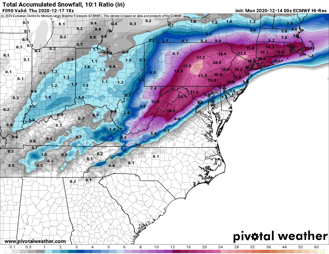
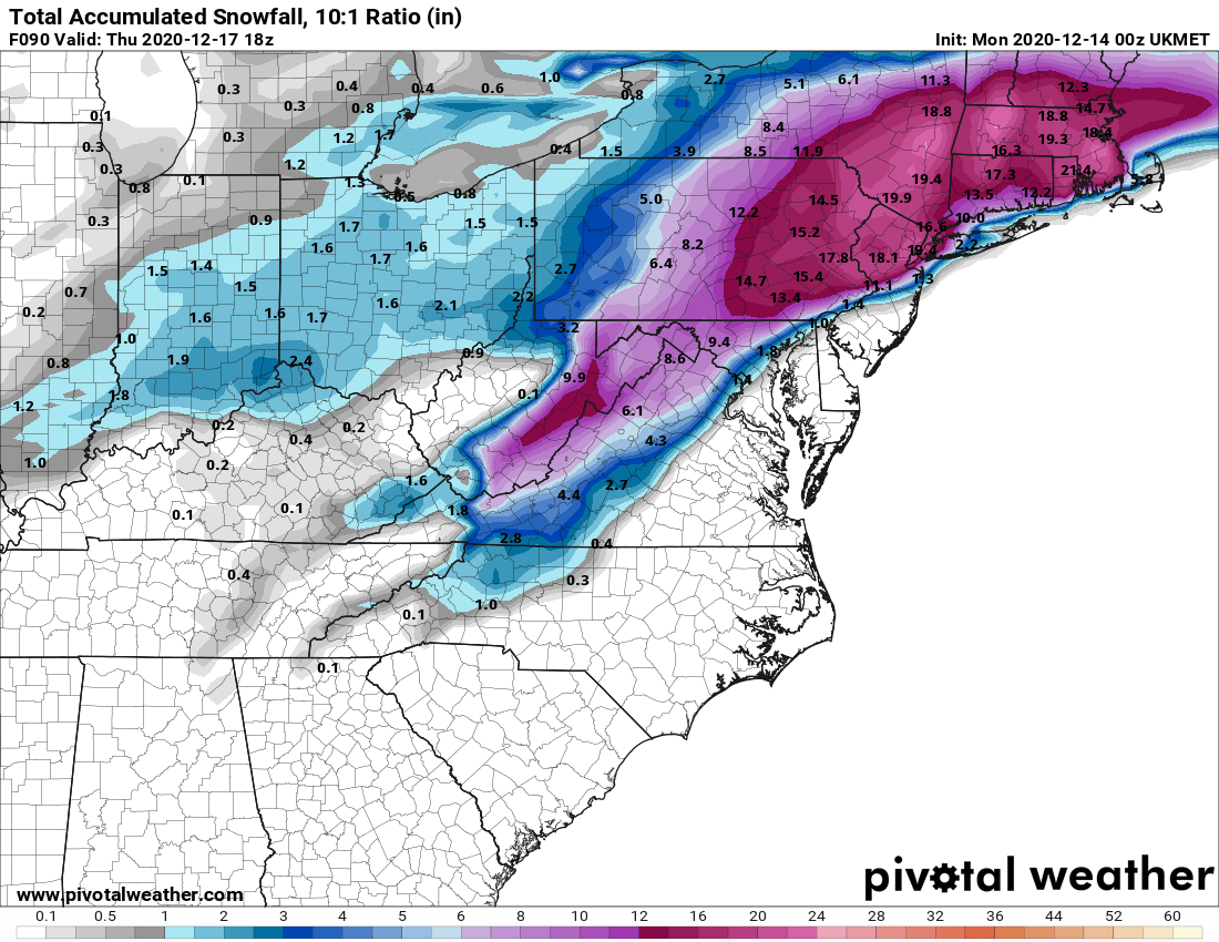
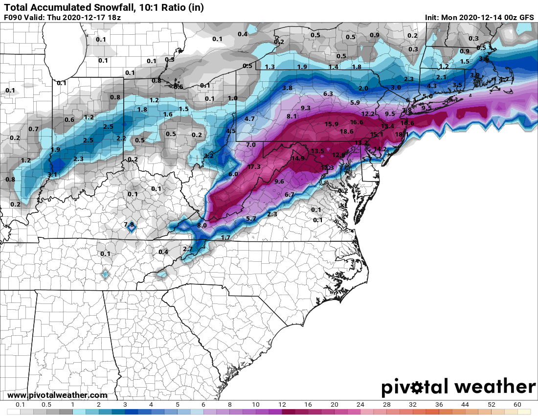
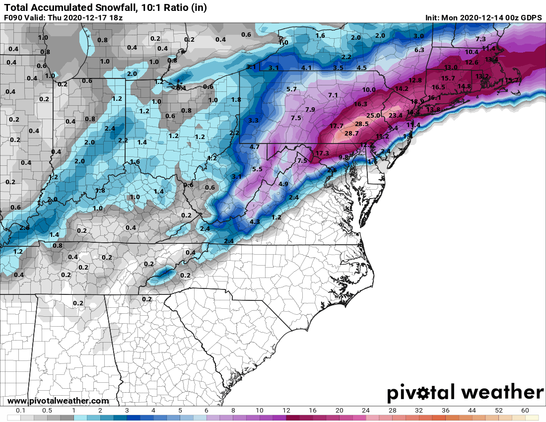
We now have 3 straight model cycles (looking at 12-hour intervals from 0Z last night to 12Z this afternoon to 0Z tonight, which just came out - data inputs were 7 pm EST) of pretty good consensus for a major to historic snowstorm on Wednesday afternoon into Thursday morning from the Euro, UK, GFS, and CMC. Everywhere from Philly to NYC, including most of NJ (only SNJ, especially near the coast looks vulnerable to a lot of rain in a couple of models), E-PA and SE-NY is modeled to get at least 8" of snow ("major") with most locations getting over 12" of snow (historic, IMO, given NYC has had 36 storms of 12" or more in 151 years or once every 4+ years - people remember storms over a foot) and some locations are modeled to get 18-24" of snow.
When I posted about this being highly unusual model consensus from 5+ days out to now on one of the weather boards, one of the very good experts there agreed and went further. He noted that the 3 major model ensembles were showing a major snowstorm from 7 days out, which he said is the first time he's seen that in a long time. Again, this is just model talk (these are models, not forecasts) and doesn't mean we're going to get a foot or more of snow everywhere, as one of the primary pieces of energy is just coming ashore in the Pac NW and hasn't been well sampled yet, so things could change. One more thing: models are showing the potential for serious wind gusts to 50-60 mph at the coast and up to 40 mph inland, so blizzard conditions are possible, as modeled (which means possible power outages) - as well as potential coastal flooding at times of high tide.
However, every met is now saying we at least now have a pretty good probability of significant snow or more. I will say this: the one huge difference for this storm over almost all of the storms last year, some of which busted badly with a lot more actual rain than predicted snow, is that we will absolutely have a strong source of cold air locked in, so a changeover to rain well inland of the coast is far less likely (but south of Toms River could get a lot of rain before any snow). The bigger "risk" to missing a big snowstorm is strong confluence leading to suppression of the storm to the SE, but no models are showing that yet. Anyway, I've always thought posting every model run is overkill, but maybe once a day (they almost all run 4X a day) is ok, so here you go...
https://www.weather.gov/phi/
https://www.33andrain.com/topic/1998-dec-16-18-possible-major-ec-snowstorm/page/57/#comments
With regard to Monday, most of the models are showing maybe 1-2" along and NW of 95 and especially N of 78, along with rain near 95 and towards the coast, so not a big deal. The NAM, however, is showing 3-6" of snow for most of the Philly-NYC area. Seems like an outlier now, but this system needs to be watched, in case more cold air filters in, as there's enough precip for a few to several inches of snow if it's cold enough.
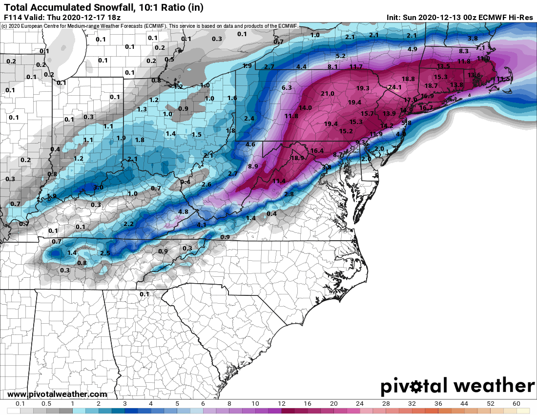
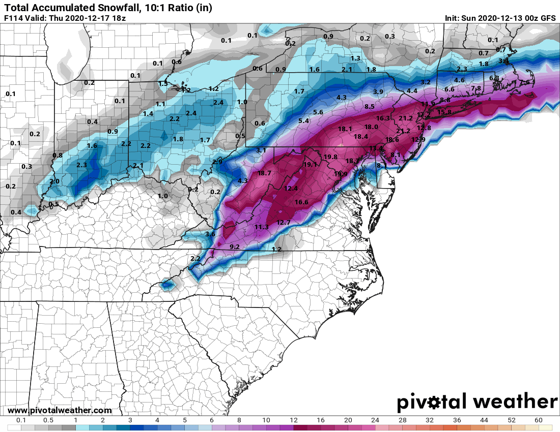
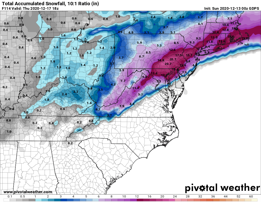
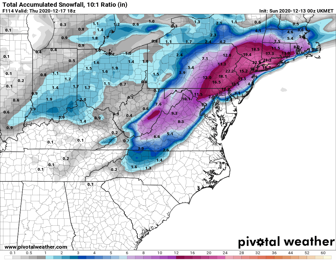
Time for the late (played disc golf all afternoon and then worked 10 hours) daily update with models. We're now within 72 hours of the event starting (mid/late Weds afternoon for most) and we still have model "consensus" with tonight's 0Z major models on a major (8" or more) to historic (12" or more) snowstorm for many to most in the Philly-NJ-NYC region, but there are enough model differences to make it all a bit confusing and to make for bust potentials in either direction.
- Relative to 24 hours ago, the Euro is just as snowy as it was last night, with 15-20" from Philly to NYC and up to 20"+ in parts of NNJ/NWNJ/EPA where better banding could set up and it also expanded the heavy snow SE by maybe 15-20 miles, so even most coastal locations would get 5-10" (only far SENJ gets little snow).
- The GFS was the southern outlier and it's even further offshore, leading to less snow for NNJ/NYC (5-10") and CNJ (8-12"), but more for the coast with 12-18" south of the Raritan.
- The CMC is a bigger hit than last night with 12-20" for most of CNJ/NNJ/NYC/EPA and even 8-12" for most of the rest of NJ/SEPA (except SE NJ near the coast with little snow).
- The UK is the one that has scared the 95 corridor crowd, as it only has 1-3" from DC to Philly and then over to about Belmar (with mostly rain, not sleet), with nada 10-20 miles SE of that line, but the gradient is so sharp that there's still over a foot from 10 miles NW of Philly to Trenton to Old Bridge and up to 18" not far NW of that line.
- The NAM and RGEM (mesoscale models) are near the end of their accurate range, so not going to include them (the NAM has lots of sleet for parts of CNJ, while the RGEM has biblical snowfall for most - wouldn't trust either until maybe tomorrow night).
- Also note that the snow will be drier/fluffier further inland which will increase snow/liquid ratios (decreased density) and snow depths vs. the maps below, which are typical 10:1 snow:liquid ratios - we could see 20:1 well N/W.
- And there will be gusty winds by late Weds/early Thursday with gusts to 50-60 mph near the coast and up to 40 mph inland, so we could have some power outages where the snow is wet and sticks to trees/powerlines (close to 95) and some big drifts, where the snow is dry. Could also be some coastal flooding at times of high tide.
Bottom line to me is that for areas 20+ miles NW of 95, I just don't see any rain, so those areas are likely to get 12-18" (at least). I also have a very hard time seeing the UK solution with mostly rain that close to 95, as we have an anomalously cold air source in place, which won't be displaced that easily. There will be a fairly sharp gradient from NW to SE in decreasing snowfall, but I don't think the UK sharpness is realistic.
My best guess is that the Euro is closest to what will happen, as it's kind of the mid-range of all the models, with the 12" line from Camden to Keansburg (with some sleet likely too) with 12-18" NW of that line and the 6" line (with 1-2" of rain) from Salem to Toms River and less SE of there. Going to be an interesting ride. The NWS-Philly discussion is below. I'm a little more bullish than they are, but the NWS-NYC is very bullish, with all snow (likely a foot or more) predicted for NENJ/NYC/LI, except Suffolk.
With regard to today, most of the models are showing maybe 1" or less (or maybe nothing) along/near 95 and 1-2" along 78 and north of there (and maybe up to 3" near 80), but a couple of models are not showing more than 1" anywhere, so not a big deal. There is no longer any outlier showing 4-6". Will be a fair amount of rain towards the coast (1/2" or so).
https://www.weather.gov/phi/
https://www.33andrain.com/topic/1998-dec-16-18-possible-major-ec-snowstorm/page/116/
https://www.americanwx.com/bb/topic...dnesday-noon-thursday-dec-16-17-2020/page/40/
National Weather Service Mount Holly NJ
257 AM EST Mon Dec 14 2020
Potential impacts (segmented by geography):
North of I-78: Regardless of the exact track of the surface low
thermal profiles should be cold enough to support all snow
during the duration of the event in this region, and given a
consensus low track near/just offshore this area would still
recieve a good portion of the precipitation shield. Consequently
am currently forecasting over a foot of snow in this region,
and a slightly more inland track then consensus could result in
snow amounts in excess of 18 inches. The main bust potential for
this zone is a southern track more similar to the GFS/GEFS
which would shunt the precip shield further south and cut down
QPF/Snow amounts considerably.
NW of I-95 and South of I-78: Given the aforementioned consensus
low track, this area would currently be in the "sweet spot" for
heavy snow, as it will remain close to the zone of max
lift/moisture while also having thermal profiles cold enough to
support mostly snow. Currently have widespread 12-18 inches for
this area, with some potential for isolated even higher amounts.
The main bust potential for this area would be a NAM-like
solution verifying which would advect warm air aloft fairly far
north, and cause changeover to sleet or maybe even freezing
rain. This would cut down totals considerably, but as for now
am leaving this area as mostly snow, but the potential warm nose
aloft bears watching.
I-95 corridor: Unfortunately (for us meteorologists) the
current consensus low track would place the primary ptype
transition zone roughly in this area, with the snowfall forecast
naturally highly uncertain. Additionally it is certainly
possible ptypes could be a real mess with initial snow (due to
wet-bulbing) transitioning to mixed precip and/or rain, and then
changing back to snow at the tail end of the event. Current
fcst snow amounts range from 4-12 inches in this zone as the
final amounts will be highly dependent upon the low track, and
the strength of any warm nose aloft. Although in general the
further north and west you go, the better your chances will be
or seeing more snow and vice-versa.
Coastal NJ/Delmarva (south of New Castle County): The center of
the low will likely track close to this area, which should
result in a primarily rain event was the warm maritime airmass
prevails. That being said a bit of snow may be possible both at
precip onset, and then at the tail end... so can`t rule out
some light (generally 2 inches or less) accumulations Wednesday
night into Thursday morning. The exception to this may be
Monmouth and Ocean counties which could receive considerably
more snow (current fcst is roughly 4-8 inches), as the low will
likely begin to cut more eastward before it reaches that
latitude resulting in cooler profiles. Additionally winds will
be strongest over these locations and wind gusts 40-50mph will
certainly be possible and wind headlines may be needed.
Last edited:
That’s what... what... uh, nope, not gonna do it. Uh-uh. No way. No. Hell no!Ah yes, the Bob Loblaw Law Blog. You, sir, are a mouthful.
thatswhatshesaid
Doh!
Dan Zarrow 101.5 For Wednesday CNJ snow starting Wed afternoon going thru Thursday morning. Some models say ending at 5 am some say 11 am. Heaviest snow overnight. 8-16 inches. 10 miles will make a difference in amounts.
Not if you face plant yourself in the snow and get a mouthful and noseful of snow. Murphy's law of science shows that cold presses kill the coronavirus.Do we have to wear a mask while snow shoveling?
Last edited:
Seems the start time shifted from 9 p.m. Tues evening to 2 a.m. Wed. morning, with lower amounts being forecasted in my locale. Yeah, these things are fluid (no pun intended), but can only hope the window shifts further out and is narrowed.If you're talking about Monday, you're likely all rain, but for the big storm, why would you think you're in the clear? I'd be surprised if you don't get at least 3-6" and more is possible. Unlikely to be all rain. The 18Z GFS just came out and gives you 15", while the 18Z NAM gives you 6" through 1 am Thursday, with 6 more hours of snow likely (the model ends at 1 am). The NWS graphic gives you 1.2" of rain followed by 6" of snow.
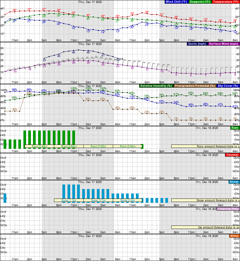
So the so called talk about model agreement as predicted has fallen apart. They agree on a storm but are all over the place on how far north it gets which is a huge difference in amounts and precip types. Forecasting 8-16 generally is a decent call from 2 days out but nothing is likely or even probable with things changing as we speak. And coastal areas very well may be spared with a couple slushy inches..thats in the table now
I love this time of the year, when Numbers posts weather data and a bullish outlook on snow and bactherac becomes Party Pooper Rex.
What's the call down here in the Cherry Hill, NJ area? About 10-15 miles east of Philly. Seems like on some of the charts, we could be change over band?
What's the call down here in the Cherry Hill, NJ area? About 10-15 miles east of Philly. Seems like on some of the charts, we could be change over band?
If anything, an added benefit of wearing a mask in the winter would be in keeping parts of the face warm and preventing chapped lips (especially if it is windy)... a big plus.Do we have to wear a mask while snow shoveling? Thankfully it appears this will be avoiding the southern coast
I love this time of the year, when Numbers posts weather data and a bullish outlook on snow and bactherac becomes Party Pooper Rex.
What's the call down here in the Cherry Hill, NJ area? About 10-15 miles east of Philly. Seems like on some of the charts, we could be change over band?
8-16 for now but we can shift downward based on new model runs
The NAM is a killjoy for the heavy amounts
I need this to miss Middlesex County. I have no interest in clearing a foot of snow.
I need this to miss Middlesex County. I have no interest in clearing a foot of snow.
You might want to move to Monmouth County
I am happy I got my 2 yr old snowblower up and running this morning. I have stabilizer in gas that sat in it since last year but the carburetor was filled with varnish-like mixture. I pulled off carb, cleaned it, squirted some carb cleaner in chamber, put the carb back on and boom started. Run rough for about ten minutes and then purred like a kitten. Ready for the snow.
Tested snowblower last night. Hopefully means I won't need it :)
I’ve worn one while snowblowing and if it’s windy or very cold.If anything, an added benefit of wearing a mask in the winter would be in keeping parts of the face warm and preventing chapped lips (especially if it is windy)... a big plus.
8-16 for now but we can shift downward based on new model runs
The NAM is a killjoy for the heavy amounts
My local weather app has been all over the map - 8 inches to 12 inches, back to 10, then up to 14, then back to 10, then to 7, back to 10, now at 5.
Smelling like a bust here. Hahaha.
We're closed to further residents.You might want to move to Monmouth County
I love the smell of bust in the morning!My local weather app has been all over the map - 8 inches to 12 inches, back to 10, then up to 14, then back to 10, then to 7, back to 10, now at 5.
Smelling like a bust here. Hahaha.
We're closed to further residents.
How long do you have to live here before the "Benny" label fades, if ever? If never, then "no new Bennies".
I'll take "What male porn stars tell their female doctor when seeking a prescription for Viagra" for $200, Alex.8 inches to 12 inches, back to 10, then up to 14, then back to 10, then to 7, back to 10, now at 5.
Smelling like a bust here. Hahaha.
A
anon_ivydyf0amkzay
Guest
It’s official...these threads are way better and more entertaining from afar...
it makes the RU#s vs bac/TK et. al. give and take so much more enjoyable...
weather queens power...activate!
form of...a forecast bust! 🕺🏼
All kidding aside...be safe on the roads!
it makes the RU#s vs bac/TK et. al. give and take so much more enjoyable...
weather queens power...activate!
form of...a forecast bust! 🕺🏼
All kidding aside...be safe on the roads!
C'mon now. You know you intended the pun. Otherwise you would've used "non-deterministic" instead. of "fluid". 🙂Seems the start time shifted from 9 p.m. Tues evening to 2 a.m. Wed. morning, with lower amounts being forecasted in my locale. Yeah, these things are fluid (no pun intended), but can only hope the window shifts further out and is narrowed.
just so I dont be accused of posting only the least snowiest model


It’s official...these threads are way better and more entertaining from afar...
it makes the RU#s vs bac/TK et. al. give and take so much more enjoyable...
weather queens power...activate!
form of...a forecast bust! 🕺🏼
All kidding aside...be safe on the roads!
well Numbers will not admit but he has a confirmation bias. I mean if hang out on the weather boards its a 99.9% membership who loves and wants the most snow. You cannot really be objective in an environment like that. The postings will always be favorable to snow, no different than cnn or ny times favorable to Dems or Fox favorable to Republicans
What time is this starting Wednesday in union county ?
sometime in the afternoon perhaps late afternoon. From this vantage point the morning before noon looks safe
ouch the NAM

Looks like I'm getting a foot plus. I'll fire up the snow blower after work today just to test run it and I'll be all ready to go.

Looks like I'm getting a foot plus. I'll fire up the snow blower after work today just to test run it and I'll be all ready to go.
where are you located?
Thanks !sometime in the afternoon perhaps late afternoon. From this vantage point the morning before noon looks safe
+1So the so called talk about model agreement as predicted has fallen apart. They agree on a storm but are all over the place on how far north it gets which is a huge difference in amounts and precip types. Forecasting 8-16 generally is a decent call from 2 days out but nothing is likely or even probable with things changing as we speak. And coastal areas very well may be spared with a couple slushy inches..thats in the table now
The model agreement has fallen apart. This storm has major bust potential.....since the gradient from heavy snow to barely anything is so tight. I've seen this story way too many times before over the past few years.
BOOM!ouch the NAM
Me likey the NAM. :)
Similar threads
- Replies
- 62
- Views
- 2K
- Replies
- 608
- Views
- 17K
- Replies
- 771
- Views
- 20K
- Replies
- 477
- Views
- 12K
- Replies
- 80
- Views
- 2K
ADVERTISEMENT
ADVERTISEMENT