Who remembers?? Jan 26th 2015. Schools and offices closing for days in advance. People descending on the supermarkets for a week's worth of essentials. Then, bupkis!


Colleges
- AAC
- ACC
- Big 12
- Big East
- Big Ten
- Pac-12
- SEC
- Atlantic 10
- Conference USA
- Independents
- Junior College
- Mountain West
- Sun Belt
- MAC
- More
- Navy
- UAB
- Tulsa
- UTSA
- Charlotte
- Florida Atlantic
- Temple
- Rice
- East Carolina
- USF
- SMU
- North Texas
- Tulane
- Memphis
- Miami
- Louisville
- Virginia
- Syracuse
- Wake Forest
- Duke
- Boston College
- Virginia Tech
- Georgia Tech
- Pittsburgh
- North Carolina
- North Carolina State
- Clemson
- Florida State
- Cincinnati
- BYU
- Houston
- Iowa State
- Kansas State
- Kansas
- Texas
- Oklahoma State
- TCU
- Texas Tech
- Baylor
- Oklahoma
- UCF
- West Virginia
- Wisconsin
- Penn State
- Ohio State
- Purdue
- Minnesota
- Iowa
- Nebraska
- Illinois
- Indiana
- Rutgers
- Michigan State
- Maryland
- Michigan
- Northwestern
- Arizona State
- Oregon State
- UCLA
- Colorado
- Stanford
- Oregon
- Arizona
- California
- Washington
- USC
- Utah
- Washington State
- Texas A&M
- Auburn
- Mississippi State
- Kentucky
- South Carolina
- Arkansas
- Florida
- Missouri
- Ole Miss
- Alabama
- LSU
- Georgia
- Vanderbilt
- Tennessee
- Louisiana Tech
- New Mexico State
- Middle Tennessee
- Western Kentucky
- UTEP
- Florida International University
High School
- West
- Midwest
- Northeast
- Southeast
- Other
- Alaska
- Arizona
- California
- Colorado
- Nevada
- New Mexico
- Northern California
- Oregon
- Southern California Preps
- Washington
- Edgy Tim
- Indiana
- Kansas
- Nebraska
- Iowa
- Michigan
- Minnesota
- Missouri
- Oklahoma Varsity
- Texas Basketball
- Texas
- Wisconsin
- Delaware
- Maryland
- New Jersey Basketball
- New Jersey
- New York City Basketball
- Ohio
- Pennsylvania
- Greater Cincinnati
- Virginia
- West Virginia Preps
ADVERTISEMENT
Install the app
How to install the app on iOS
Follow along with the video below to see how to install our site as a web app on your home screen.
Note: This feature may not be available in some browsers.
You are using an out of date browser. It may not display this or other websites correctly.
You should upgrade or use an alternative browser.
You should upgrade or use an alternative browser.
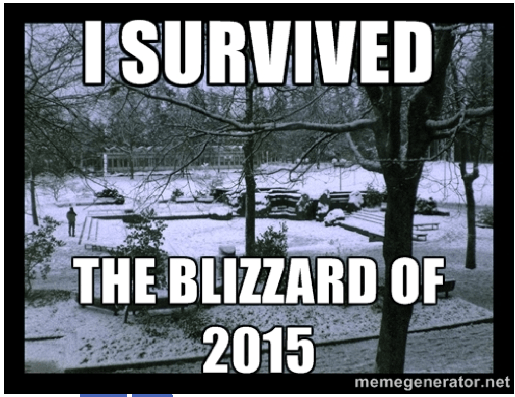
OT: its the 9 year anniversary of the biggest snow forecast bust of all time?
- Thread starter Salvi's Headband
- Start date

Why forecasters got the ‘monster’ Blizzard of 2015 so very wrong for N.J.
What could get the most attention in the aftermath of the blown forecast is the correct solution was staring the weather service in the face the entire time.
Need to revive that thread!!!Why forecasters got the ‘monster’ Blizzard of 2015 so very wrong for N.J.
What could get the most attention in the aftermath of the blown forecast is the correct solution was staring the weather service in the face the entire time.www.nj.com
Your probably correct. Or #s paid John 0 some big $ to delete it 🤣i bet it was locked
This was the only thread I was able to find:
Rutgers University to close early due to monster N.J. blizzard
Rutgers University to close early due to monster N.J. blizzard
sometimes some of these threads fall through the cracks but for some reason are not searchable. I know alot of the weather threads end up being locked...i did see some round table archive threads from 2011!Sadly the catalog for threads goes back to mid-Feb, 2015. Prior to that, once threads fell off the page they weren't saved. Sucks. I'm sure the older threads exist somewhere, but there's just no way to access them.
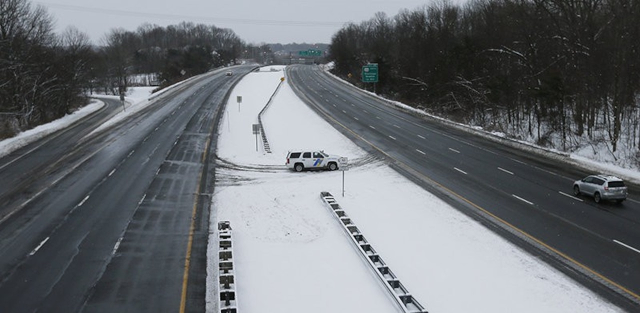
Not the biggest, IMO, especially for NYC, the NJ coast and areas NE of there that at least got 8-14" of snow, but was definitely the biggest bust I can recall west of those areas in most of NJ/EPA that generally got a few inches to maybe 3-6" (we got 6" in Metuchen) vs forecasts of 18-30". IMO, March 2001 was just as bad and worse for my house and NYC, where the whole region was forecast to get 1-2 feet of snow even after the storm started and almost everyone SW of CT got only 2-4" of snow/sleet, if that (we got 2"). Both were pretty bad.Who remembers?? Jan 26th 2015. Schools and offices closing for days in advance. People descending on the supermarkets for a week's worth of essentials. Then, bupkis!
https://thestarryeye.typepad.com/we...dicted-snowstorms-that-failed-to-deliver.html
I actually saved most of that thread on my computer and could probably share a page or two if anyone is truly interested. It was baaaaaaadddd, lol. I remember going to Hailey's pub that evening to enjoy the first part and we got about 3" by 10 pm, but then it lightened up and I got a bit nervous, so we went home and I saw all hell had broken loose on the weather boards, but the NWS hadn't backed off yet. I posted in the thread that the storm was likely to be way underdone SW of NYC, but way too late for it to be meaningful. Shit happens.
That was a fun day. :)Who remembers?? Jan 26th 2015. Schools and offices closing for days in advance. People descending on the supermarkets for a week's worth of essentials. Then, bupkis!
IIRC, you ran away and hid for a week or two. Almost felt bad for you on that one.I actually saved most of that thread on my computer and could probably share a page or two if anyone is truly interested. It was baaaaaaadddd, lol. I remember going to Hailey's pub that evening to enjoy the first part and we got about 3" by 10 pm, but then it lightened up and I got a bit nervous, so we went home and I saw all hell had broken loose on the weather boards, but the NWS hadn't backed off yet. I posted in the thread that the storm was likely to be way underdone SW of NYC, but way too late for it to be meaningful. Shit happens.
lol, no, wrong as usual. I always stick around even after a bust, as busts are learning experiences.IIRC, you ran away and hid for a week or two. Almost felt bad for you on that one.
There was definitely one mega-bust that broke you for a while. Thought it was this one, but not sure.lol, no, wrong as usual. I always stick around even after a bust, as busts are learning experiences.
lol, no, wrong as usual. I always stick around even after a bust, as busts are learning experiences.
I've had a couple of great learning experiences with busts!

learning experiences and yet people always memoryhole themlol, no, wrong as usual. I always stick around even after a bust, as busts are learning experiences.
Awwwww I remember this drama queen bust…I still lived in orange cty, I think 18-24” was the histrionics forecast…I think we got 2”? It was hilarious. There were a few other memorable ones but this one was the most mock-worthy.
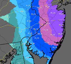
The forecast was even more bullish the day before the map you posted came out (the map above is from Monday morning, while the map below was from Sunday afternoon). The interesting thing was that almost all of the models on Sunday night backed off considerably on snowfall (to about 8-14" for eastern NJ and 4-8" for western NJ, roughly), but the Euro and NAM did not, so the NWS only lowered snowfall forecasts a bit. And then the Monday 6Z and 12Z models went back to showing more significant snows again - except for the GFS.Never forget.
But it started becoming clear the bust was in on Monday evening when the heavy radar returns just off and along the immediate NJ coast kept disintegrating as they moved inland due to much more dry air than expected inland. The combination of more dry air and the storm actually forming well NE of where it was originally forecast to do so killed the snow for all of NJ except within 5-10 miles of the Hudson and the Shore.
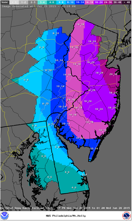
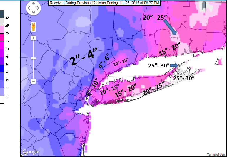
So what did the real map end up looking like?Never forget.
The actual totals.
Here you go. There's also a good 10-page thread on AmericanWx about the bust and the WaPo article is also very good. It's also interesting that as much as people dis TWC, they were the only major outlet I know of that never bought into more than 18" for NYC or anywhere in NJ, as they were riding the GFS and the GFS ended up being right. Was a huge coup for them. Problem was for the 2-3 storms before that in 2015, the GFS performed horribly, so it's easy to see why it was dismissed especially when the Euro and NAM were well aligned on big snows. In the old days, there used to be an "EE rule" that whenever the Euro and the NAM (then known as the ETA) were aligned, they should be followed. It generally worked pretty well, but not this time. My more detailed post-mortem from the storm, which I posted here and elsewhere, is below.So what did the real map end up looking like?
The actual totals.
https://www.americanwx.com/bb/topic/45530-dissecting-the-bust/
https://www.washingtonpost.com/news...y-was-so-bad-and-what-should-be-done/?hpid=z5
Here are a few words about our busted blizzard. I hope to do a more thorough post-mortem at some point, but thought a couple of quick comments were in order. First, the storm was modeled nearly perfectly by the Euro, with regard to structure and precip – the only problem was around 6-7 pm, when the upper low approaching from the NW reached the surface low coming up the coast and “phased” the two systems, that occurred later than expected, which meant it occurred ~70 miles east of where the Euro had predicted (it did occur where the much maligned GFS had predicted) – that essentially meant the entire precip field was displaced about 70 miles east of where the Euro and the NWS and 90% of pros had predicted, meaning areas to the west of the storm in NYC/NJ were now too far from the storm to get big snows.
Riding the Euro, which had never busted this badly on a major east coast snowstorm, and had never really wavered in days seemed like a reasonable thing to do even without model consensus. Yes, the newly upgraded GFS, which the Weather Channel was following for the most part, had close to the right solution in the last day or so, but it had done poorly on the rainstorm of 2 weeks ago and Friday night’s snow/mix, so confidence in it was low. The one criticism you could say – and I said this at 2 am on Monday – was why not predict 12-24” instead of 24-36”? And the NWS did reduce to 18-24” at 4 am on Monday, but then popped it back up to 24-36” Monday afternoon (for NYC eastward, despite even more model disagreement). If the prediction for eastern NJ/NYC had been 12-24” and 30” fell, nobody would have said much and if it was 12-24” and 10-14” fell in NYC, as occurred, it would have been a minor bust at worst. Sure, the 6-10” in NENJ would still be a bust, but not a huge bust.
And that meant that everyone got the amount of snowfall predicted for places ~70 miles to the west. So, much of NE NJ got the 6-10” expected in eastern PA, and NYC got the 10-14” expected in far western NJ and so on. Over a 70 mile stretch, Newark got 7”, Central Park got 10”, eastern Nassau County got 18” and Islip in Suffolk County, ~70 miles east of Newark, got 25”, which is about what would have fallen in Newark and eastern NJ (and NYC), where the blizzard warnings were, if not for the last minute surprise location of the consolidatoin of the upper and surface lows Monday evening.
Now, why it took another 4-6 hours for the NWS and others to reduce their snowfall forecasts is a question I’m still asking and haven’t seen an answer to. Certainly, by 8-9 pm, when we had seen no snow from NYC westward for a few hours, the writing was on the wall. Maybe they were just hoping, like I was, staring at that friggin' heavy snow band advancing at a snail’s pace just off the NJ coast for hours, but never really making it much inland. Regardless, a busted forecast was then made worse by a very slow response to a huge change in the storm’s evolution – the NWS didn’t reduce accumulations significantly until almost 1 am Tuesday. Oi vey. I did speak to a met who used to work at Mt. Holly and now works at another office out west and he said there was a lot of politics going on at the national level and they basically insisted the NYC/Philly offices not back down until it was absolutely certain they’d bust. Interesting.
I tend not to remember things that never happened.Who remembers?? Jan 26th 2015. Schools and offices closing for days in advance. People descending on the supermarkets for a week's worth of essentials. Then, bupkis!
March 2001 was the king of busts. I remember Paul Kocin putting us under the 24-35 inch range like 12 hours before and we ended up with 2-3” of sleet and snow. That was a fun one to track, I was 10 at the time and would wake up early to go on to the old Unisys Weather site to check up on the models. It was also the first storm in my lifetime where they cancelled school a full day in advance. Devastating for the weenies, but I remember just being happy to get a free day off. I forget what happened with that one, IIRC it was a miller B that missed the phase and instead of capturing and stalling it punted OTS while treating us to a dry slot.
2015 was the second worst, was living in New Brunswick at the time and we got like 6-10, about half of what was forecasted. I remember there was a bone crusher of a deform band that sat about 50 miles off the NJ coast.
2015 was the second worst, was living in New Brunswick at the time and we got like 6-10, about half of what was forecasted. I remember there was a bone crusher of a deform band that sat about 50 miles off the NJ coast.
lol, no, wrong as usual. I always stick around even after a bust, as busts are learning experiences.

If you’re in central jersey we had big december storms in both 09 and 10.The snow storm I remember hitting my area really hard was I believe Dec 2009 or 2010.
I didn't remember this at all, until yesterday when a Facebook post of mine from 2015 came up. Trying to recall this...Who remembers?? Jan 26th 2015. Schools and offices closing for days in advance. People descending on the supermarkets for a week's worth of essentials. Then, bupkis!
Similar threads
- Replies
- 771
- Views
- 20K
ADVERTISEMENT
ADVERTISEMENT