
Colleges
- American Athletic
- Atlantic Coast
- Big 12
- Big East
- Big Ten
- Colonial
- Conference USA
- Independents (FBS)
- Junior College
- Mountain West
- Northeast
- Pac-12
- Patriot League
- Pioneer League
- Southeastern
- Sun Belt
- Army
- Charlotte
- East Carolina
- Florida Atlantic
- Memphis
- Navy
- North Texas
- Rice
- South Florida
- Temple
- Tulane
- Tulsa
- UAB
- UTSA
- Boston College
- California
- Clemson
- Duke
- Florida State
- Georgia Tech
- Louisville
- Miami (FL)
- North Carolina
- North Carolina State
- Pittsburgh
- Southern Methodist
- Stanford
- Syracuse
- Virginia
- Virginia Tech
- Wake Forest
- Arizona
- Arizona State
- Baylor
- Brigham Young
- Cincinnati
- Colorado
- Houston
- Iowa State
- Kansas
- Kansas State
- Oklahoma State
- TCU
- Texas Tech
- UCF
- Utah
- West Virginia
- Illinois
- Indiana
- Iowa
- Maryland
- Michigan
- Michigan State
- Minnesota
- Nebraska
- Northwestern
- Ohio State
- Oregon
- Penn State
- Purdue
- Rutgers
- UCLA
- USC
- Washington
- Wisconsin
High Schools
- Illinois HS Sports
- Indiana HS Sports
- Iowa HS Sports
- Kansas HS Sports
- Michigan HS Sports
- Minnesota HS Sports
- Missouri HS Sports
- Nebraska HS Sports
- Oklahoma HS Sports
- Texas HS Hoops
- Texas HS Sports
- Wisconsin HS Sports
- Cincinnati HS Sports
- Delaware
- Maryland HS Sports
- New Jersey HS Hoops
- New Jersey HS Sports
- NYC HS Hoops
- Ohio HS Sports
- Pennsylvania HS Sports
- Virginia HS Sports
- West Virginia HS Sports
ADVERTISEMENT
You are using an out of date browser. It may not display this or other websites correctly.
You should upgrade or use an alternative browser.
You should upgrade or use an alternative browser.
OT: Snowstorm Friday
- Thread starter mikemarc1
- Start date

what could bump totals up and we have seen it before with sort of meh systems is the higher snow ratios so that will be something to nail down in the next 24-36 hours
BTW,,,, just came back from the Hillsborough Deli. The MILFS are not aroused at the amounts either.when the NAM isnt even aroused enough to spit out its usually overdone totals its usually onto something.

Tell that to the men hanging out their counting their change in their pocketsThis "Hillsborough Deli" bit really is way played out.
Ain’t nothing innocent about sheep. And it’s not violating if they say “baaa”. 😀What about the coke and hookers bit?
@mildone 😝 or the violating of innocent sheep??
I see someone else commented on it as well…oops
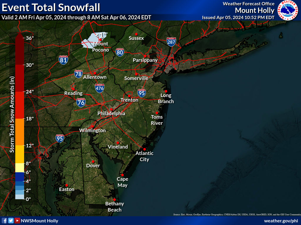
Mt holly going 2-4...winter weather advisory
DEZ001-002-MDZ012-015-019-020-NJZ009-010-012-015>019-021-PAZ070-
071-101>106-060915-
/O.NEW.KPHI.WW.Y.0003.220107T0300Z-220107T1500Z/
New Castle-Kent-Kent MD-Queen Annes-Talbot-Caroline-Hunterdon-
Somerset-Middlesex-Mercer-Salem-Gloucester-Camden-
Northwestern Burlington-Cumberland-Delaware-Philadelphia-
Western Chester-Eastern Chester-Western Montgomery-
Eastern Montgomery-Upper Bucks-Lower Bucks-
Including the cities of Wilmington, Dover, Chestertown,
Centreville, Easton, Denton, Flemington, Somerville,
New Brunswick, Trenton, Pennsville, Glassboro, Camden,
Cherry Hill, Moorestown, Mount Holly, Millville, Media,
Philadelphia, Honey Brook, Oxford, West Chester, Kennett Square,
Collegeville, Pottstown, Norristown, Lansdale, Chalfont,
Perkasie, Morrisville, and Doylestown
306 PM EST Wed Jan 5 2022
...WINTER WEATHER ADVISORY IN EFFECT FROM 10 PM THURSDAY TO 10 AM
EST FRIDAY...
* WHAT...Snow expected. Total snow accumulations of 2 to 4
inches.
* WHERE...Portions of central, northern, northwest and southern
New Jersey, southeast Pennsylvania, northeast Maryland and
central and northern Delaware.
* WHEN...From 10 PM Thursday to 10 AM EST Friday.
* IMPACTS...Plan on slippery road conditions. The hazardous
conditions could impact the morning commute.
* ADDITIONAL DETAILS...Widespread accumulating snowfall is
expected across the advisory area Thursday night with rates up
to 1 inch per hour possible. A narrow band of locally higher
amounts of 4 to 6 inches or higher is possible as well.
PRECAUTIONARY/PREPAREDNESS ACTIONS...
Slow down and use caution while traveling.
The latest road conditions for the state you are calling from can
be obtained by calling 5 1 1.
Fictitious? Fictitious? Are you for real with that claim? 🙂I consider it a different thing. Hookers and blow are real. So are sheep. The Hillsborough Deli and all corresponding "MILFs" are entirely fictitious.
Fictitious? Fictitious? Are you for real with that claim? 🙂
100% pure fiction. I should know, I once tried to stop by this alleged Hillsborough Deli, on my way home from the Paterson Home Depot. Or Passaic... one of those.
where is this place? I have to go there some day and see if I can get luckyTell that to the men hanging out their counting their change in their pockets
Well... okay.100% pure fiction. I should know, I once tried to stop by this alleged Hillsborough Deli, on my way home from the Paterson Home Depot. Or Passaic... one of those.
On the way home from Home Depot, eh? Wanted to show them your tool? 😃
Great place for fencing.100% pure fiction. I should know, I once tried to stop by this alleged Hillsborough Deli, on my way home from the Paterson Home Depot. Or Passaic... one of those.
Ain’t nothing innocent about sheep. And it’s not violating if they say “baaa”. 😀


That's just so wrong. Literally.
Ask any sheep and they'll tell you. Baaa means yes.
I don't know how we are going to handle 3" of snow. I mean, I will be drawn to the window multiple times and it will interrupt my tv shows. And what if I have to walk in it to check the mailbox! My footsies might get snow on them!!
With @DJ Spanky , stolen jewelry is more like it.Epee, Sabre, or Foil?
Man's gotta earn a buck. If they didn't want it stolen, they shoulda locked it up tighter.Exactly!
I have to drive a child to school every day to avoid the school bus and the quarantine that results if one single child on the bus tests positive. The roads in Hunterdon are not fun in bad weather during rush hour. $$$$I've noticed that most of the people I know personally who like snow don't have to drive in it. How anybody could wish for slippery roads followed by days of navigating snow banks and limited parking is beyond me.
There were 2 accidents involving 65 cars near where Rt 18 meets Rt 36 in Eatontown early this morning. My eldest doesn't live far from there and was woken up by sirens coming from every direction. A real mess but last I heard no fatalities .
Take it to the "freezing rain for Wednesday morning" thread.There were 2 accidents involving 65 cars near where Rt 18 meets Rt 36 in Eatontown early this morning. My eldest doesn't live far from there and was woken up by sirens coming from every direction. A real mess but last I heard no fatalities .
the short term models like the HRRR are much more robust with snowfall totals, something to keep an eye on
Models not that great for moderate snows. There are hints on some models of potential of some heavier banding setting up. Where and even if it happens is pretty unknown.
some models are pretty tragic like the Ukie

the just in 12z euro rather meh with totals

the gfs similar to the Euro with amounts

NAM also not that enthused

For winter storms inside 48 hours, I like the NAM.
NAM NAM NAM NAM NAMwhen the NAM isnt even aroused enough to spit out its usually overdone totals its usually onto something.
Please.
There are 2 NAMs and one is arousedNAM NAM NAM NAM NAM
Please.
Then give it some saltpeter.There are 2 NAMs and one is aroused
Nick Gregory liked 3"-5" and lets see if Lonnie Quinn rolls up the sleeves tomorrow as he was in the 2"-4" camp along with Dave Curren.


NWS cut back snowfall a bit, so now it's more like a 2-4" event - although the 6Z models have come in with a bit more snow so far, so we may see that bump back up if the 12Z models confirm that. Still a ways to go before the event...


Back from my 16.75 hour trip (14.75 hours driving 1130 miles from Vero, plus a 2-hour disc golf diversion) - best time ever, since there was seriously no traffic slowdowns the entire trip, including in VA on 95 and through DC around 7 pm (maybe people were afraid of 95 from the last 2 days, lol).
Updated NWS maps from this evening are below, which led to area-wide advisories for 2-4" for most by NWS-Philly (NYC office should follow at 4 am), although the NWS is still very worried about many folks getting 4-6" in banding, as per their comments in italics, below. Tonight's 0Z models are generally looking a bit snowier than the 12Z models, with exceptions. The really interesting thing is that almost all of the mesoscale and convection-allowing models (HRRR, NAM-3km, RDPS and RAP) are showing more snow (like 4-6/7"), due to convective mesoscale banding (which they should "see" better); the outlier is the NAM 12km, which is not as good at convection as the 3km version. Also, the GFS and Euro are quite bullish (large areas of 4-6" with 2-4" for some), but the CMC/UK are not (1-3"), further complicating forecasts.
While our official snowfall
forecasts remain capped to the 2 to 4 inch range for much of the
CWA, there are a couple important things to note: 1) This will be a
fast moving system with snow falling over just several hours that
will unfortunately coincide with the Friday AM commute. 2) We
still think there is the potential for an embedded heavier band
of snow with totals in the 4-6+ inch range. Uncertainty still on
exactly where this would occur but somewhere near or just south
of the I-95 corridor appears most heavily favored.
This makes forecasting difficult, as it's difficult to predict the intensity, duration and placement of frontogenetic banding features, which could easily convert a general 2-4" forecast, like we have from the NWS, into a 4-6" event (or more) where the bands set up. The question is do you increase amounts or just note that there will be areas of >4" and note where those are most likely? Lee Goldberg was thinking these bands are most likely for LI and coastal NJ, bringing those areas to 4" or more vs. a general 2-4" forecast for almost everyone (except well NW, like the Poconos/Catskills, which are likely to get less snow). Nick Gregory is predicting an area-wide 3-5".
Wherever such bands set up, assuming they do and put down 4-6" (or even a bit more), impacts will likely be substantial on the roads given that the heaviest snow is likely to fall between 2 am and 10 am Friday morning. Could be a real mess in some spots - and even 2-3" falling during rush hour with temps below 32F for the entire event for just about everyone (and a very low sun angle this time of year) will have some impact, as the snow will accumulate easily on any untreated surfaces. In addition, snow ratios could be higher than usual, given good modeled snow growth in the dendritic growth zone and the colder temps - this could give more snow depth (but the same mass).
This clearly has a higher ceiling than most 2-4" events, as the 1 in 10 worst case probability has over 8" for most locations (that's unusually high). Worth remembering what 4-6" of snow can do at the "wrong" time a la the Nov-2018 event, where the snow all fell after everyone was at work - hopefully, many stay home on Friday, so we don't get massive traffic jams, should the system overperform. Weenie nation is fully at attention, lol, as per the chatter in the storm thread.
https://www.weather.gov/phi/
https://www.33andrain.com/topic/2073-1722-east-coast-winter-weather-event/page/35/


don't count on it - and you're kind of in the bullseye right now...NAM NAM NAM NAM NAM
Please.
Back from my 16.75 hour trip (14.75 hours driving 1130 miles from Vero, plus a 2-hour disc golf diversion) - best time ever, since there was seriously no traffic slowdowns the entire trip, including in VA on 95 and through DC around 7 pm (maybe people were afraid of 95 from the last 2 days, lol).
Updated NWS maps from this evening are below, which led to area-wide advisories for 2-4" for most by NWS-Philly (NYC office should follow at 4 am), although the NWS is still very worried about many folks getting 4-6" in banding, as per their comments in italics, below. Tonight's 0Z models are generally looking a bit snowier than the 12Z models, with exceptions. The really interesting thing is that almost all of the mesoscale and convection-allowing models (HRRR, NAM-3km, RDPS and RAP) are showing more snow (like 4-6/7"), due to convective mesoscale banding (which they should "see" better); the outlier is the NAM 12km, which is not as good at convection as the 3km version. Also, the GFS and Euro are quite bullish (large areas of 4-6" with 2-4" for some), but the CMC/UK are not (1-3"), further complicating forecasts.
While our official snowfallforecasts remain capped to the 2 to 4 inch range for much of theCWA, there are a couple important things to note: 1) This will be afast moving system with snow falling over just several hours thatwill unfortunately coincide with the Friday AM commute. 2) Westill think there is the potential for an embedded heavier bandof snow with totals in the 4-6+ inch range. Uncertainty still onexactly where this would occur but somewhere near or just southof the I-95 corridor appears most heavily favored.
This makes forecasting difficult, as it's difficult to predict the intensity, duration and placement of frontogenetic banding features, which could easily convert a general 2-4" forecast, like we have from the NWS, into a 4-6" event (or more) where the bands set up. The question is do you increase amounts or just note that there will be areas of >4" and note where those are most likely? Lee Goldberg was thinking these bands are most likely for LI and coastal NJ, bringing those areas to 4" or more vs. a general 2-4" forecast for almost everyone (except well NW, like the Poconos/Catskills, which are likely to get less snow). Nick Gregory is predicting an area-wide 3-5".
Wherever such bands set up, assuming they do and put down 4-6" (or even a bit more), impacts will likely be substantial on the roads given that the heaviest snow is likely to fall between 2 am and 10 am Friday morning. Could be a real mess in some spots - and even 2-3" falling during rush hour with temps below 32F for the entire event for just about everyone (and a very low sun angle this time of year) will have some impact, as the snow will accumulate easily on any untreated surfaces. In addition, snow ratios could be higher than usual, given good modeled snow growth in the dendritic growth zone and the colder temps - this could give more snow depth (but the same mass).
This clearly has a higher ceiling than most 2-4" events, as the 1 in 10 worst case probability has over 8" for most locations (that's unusually high). Worth remembering what 4-6" of snow can do at the "wrong" time a la the Nov-2018 event, where the snow all fell after everyone was at work - hopefully, many stay home on Friday, so we don't get massive traffic jams, should the system overperform. Weenie nation is fully at attention, lol, as per the chatter in the storm thread.
https://www.weather.gov/phi/
https://www.33andrain.com/topic/2073-1722-east-coast-winter-weather-event/page/35/
As expected, in response to the models showing a bit more snow (most, not all, and especially the mesoscale/convective ones) the NWS upped snowfall totals significantly, i.e., by about 0.5-1.0" for most NWS-Philly locations and by 1-2" for most NWS-NYC locations and the NWS-NYC issued advisories for all of their counties. Basically a solid 3-5" event with some locations possibly getting more under heavier bands and some getting on the low end who miss out on the bands. Friday morning rush will likely be a mess.


Edit: found the first map on 33andrain and made the 2nd map from the NDFD (National Digital Forecast Database, which is essentially the NWS "grids" they use for their office maps, as far as I can tell) and found the 3rd map at the Eastern Region website. Shows it all on one map for our region and for the whole northeast US.


Last edited:
roughly 2 am to 10 am Friday - should be over by noon...Timing on this? Will it be over by noon tomorrow?
Id go with 3-6 inches to cover the bases. So yesterday the models seemed to back off on amounts but overnight seemed to rev them up again along with the potential for banding. There could be some lollipops of 7-8 inches. Could the storm underperform...well yes always the potential for it to become a strung out mess during the transfer of energy..thats when we end up with busts but really all models seem on the board for a moderate snow event.
Maybe NW Jersey will be more like a 2-4 but we'll see
Maybe NW Jersey will be more like a 2-4 but we'll see
Nor do they have to shovel it. Especially shoveling out the car and driveway.I've noticed that most of the people I know personally who like snow don't have to drive in it. How anybody could wish for slippery roads followed by days of navigating snow banks and limited parking is beyond me.
No point in going to wotk or school tomorrow given the timing of this system from about 12-8am maybe winding down a bit later at the coast
Stop hyping bigger totals!Id go with 3-6 inches to cover the bases. So yesterday the models seemed to back off on amounts but overnight seemed to rev them up again along with the potential for banding. There could be some lollipops of 7-8 inches. Could the storm underperform...well yes always the potential for it to become a strung out mess during the transfer of energy..thats when we end up with busts but really all models seem on the board for a moderate snow event.
Maybe NW Jersey will be more like a 2-4 but we'll see
#SnowFanBoi
Similar threads
- Replies
- 19
- Views
- 913
- Replies
- 6
- Views
- 1K
- Replies
- 4
- Views
- 280
- Replies
- 2
- Views
- 270
ADVERTISEMENT
ADVERTISEMENT