ADVERTISEMENT

OT: Another Heavy Rainstorm (2-4") for All and Some Snow Well NW (and major snow for interior NY/New England)

Rainfall totals as of 1 p.m. from app.com

Monmouth County NJ rainfall totals​

as of 1 p.m. April 3, 2024

  • Belmar-Farmingdale: 1.33 inches
  • Cream Ridge: 1.49 inches
  • Freehold-Marlboro: 1.78 inches
  • Holmdel: 1.87 inches
  • Matawan: 2.31 inches
  • Middletown: 1.41 inches
  • Millstone Township: 1.62 inches
  • Monmouth Beach: 1.30 inches
  • Oceanport: 2.07 inches
  • Oakhurst: 1.60 inches
  • Sea Girt: 1.78 inches
  • South Howell: 1.88 inches
  • Wall Township: 2.03 inches
  • Beach Haven: 1.19 inches
  • Brick: 2.34 inches
  • Brielle: 2.20 inches
  • Cedar Bridge: 1.90 inches
  • Fort Dix: 2.04 inches
  • Harvey Cedars: 2.25 inches
  • Jackson 1.97 inches
  • Lakewood: 1.87 inches
  • Mantoloking: 1.65 inches
  • Miller Air Park: 1.81 inches
  • North Beach Haven: 2.57 inches
  • Pinewald: 2.63 inches
  • Point Pleasant: 2.14 inches
  • Point Pleasant Beach: 1.50 inches
  • Seaside Heights: 2.12 inches
  • Ship Bottom: 1.67 inches
  • South Seaside Park: 1.48 inches
  • Surf City: 2.24 inches
  • Toms River: 2.34 inches
  • West Creek: 2.04 inches

  • Cape May Courthouse: 3.08 inches
  • Fortescue: 2.63 inches
  • Pittstown: 2.39 inches
  • Ringoes: 6.71 inches
  • Trenton: 3.07 inches
  • Turnersville: 3.62 inches
  • Voorhees: 3.34 inches
  • Waldick: 2.38 inches
 
Had just under 2 inches when I left for work this morning.
 
Curious from firefighter perspective, and I think I may know the answer--did the liquid nitrogen spill from the exploded pipe, and did the local or county Haz Mat team respond. Guessing that liquid N2 just dissipates and other than cold exposure to whatever liquid N2 contacts, it is fairly innocuous?
Multiple power/backup failures led to a small (couple of feet) section of pipe which normally contains flowing cold liquid nitrogen to stop flowing and warm up, which leads to evaporation and pressure in the pipe, which led the pipe to explode - a number of much larger industrial accidents that have occurred from stagnant liquid nitrogen in sealed pipes/containers. And while liquid nitrogen explosions don't involve fire, shrapnel from exploded shards can be very dangerous to personnel/equipment, plus there are always asphyxiation risks if there are vapor releases near people. From what I recall, since the incident didn't involve injuries and posed no ongoing risk, there was no need for Haz Mat responders, although my expertise was in doing the root cause analysis and I was not on point for external communications which may have occurred.
 
  • Like
Reactions: Knight Shift
Rainfall totals as of 1 p.m. from app.com

Monmouth County NJ rainfall totals​

as of 1 p.m. April 3, 2024

  • Belmar-Farmingdale: 1.33 inches
  • Cream Ridge: 1.49 inches
  • Freehold-Marlboro: 1.78 inches
  • Holmdel: 1.87 inches
  • Matawan: 2.31 inches
  • Middletown: 1.41 inches
  • Millstone Township: 1.62 inches
  • Monmouth Beach: 1.30 inches
  • Oceanport: 2.07 inches
  • Oakhurst: 1.60 inches
  • Sea Girt: 1.78 inches
  • South Howell: 1.88 inches
  • Wall Township: 2.03 inches
  • Beach Haven: 1.19 inches
  • Brick: 2.34 inches
  • Brielle: 2.20 inches
  • Cedar Bridge: 1.90 inches
  • Fort Dix: 2.04 inches
  • Harvey Cedars: 2.25 inches
  • Jackson 1.97 inches
  • Lakewood: 1.87 inches
  • Mantoloking: 1.65 inches
  • Miller Air Park: 1.81 inches
  • North Beach Haven: 2.57 inches
  • Pinewald: 2.63 inches
  • Point Pleasant: 2.14 inches
  • Point Pleasant Beach: 1.50 inches
  • Seaside Heights: 2.12 inches
  • Ship Bottom: 1.67 inches
  • South Seaside Park: 1.48 inches
  • Surf City: 2.24 inches
  • Toms River: 2.34 inches
  • West Creek: 2.04 inches

  • Cape May Courthouse: 3.08 inches
  • Fortescue: 2.63 inches
  • Pittstown: 2.39 inches
  • Ringoes: 6.71 inches
  • Trenton: 3.07 inches
  • Turnersville: 3.62 inches
  • Voorhees: 3.34 inches
  • Waldick: 2.38 inches
Dunno about that 6.71 number in Ringoes.
 
Dunno about that 6.71 number in Ringoes.
No way that's right. NJ State Climatologist map and estimated rainfall from radar map both show in the 1.5-2.0" range and don't show anywhere in NJ with over 3" over the past 48 hours and this isn't a mesoscale event, like t-storms, where one area can get far more than nearby areas. Below is a link to this morning's NWS briefing on the event.

https://www.weather.gov/media/phi/current_briefing.pdf
 
Snow mixing in now
Very unlikely to be "snow" with the column too warm to support snow staying intact to the ground, so it's more likely to be graupel (supercooled liquid freezing on a snowflake well up in the column, forming an icy solid that can sometimes make it to the ground without fully melting).
 
Very unlikely to be "snow" with the column too warm to support snow staying intact to the ground, so it's more likely to be graupel (supercooled liquid freezing on a snowflake well up in the column, forming an icy solid that can sometimes make it to the ground without fully melting).
In my day, we called it wet snow. I thought graupel is something you drink?
 
  • Like
Reactions: Section124
Closing thoughts from the above article. Well said.

“The next time you encounter a troll online, remember:

  1. These trolls are some truly difficult people.
  2. It is your suffering that brings them pleasure, so the best thing you can do is ignore them.”
This forum should have a way to block these dolts from seeing your posts then all of the conflict would go away.
 
Have lost power twice today in Sayreville.
Don't know if it's wind/rain related.
 
Very unlikely to be "snow" with the column too warm to support snow staying intact to the ground, so it's more likely to be graupel (supercooled liquid freezing on a snowflake well up in the column, forming an icy solid that can sometimes make it to the ground without fully melting).
Uh, oh. . . . It's on. 🤣
 
Very unlikely to be "snow" with the column too warm to support snow staying intact to the ground, so it's more likely to be graupel (supercooled liquid freezing on a snowflake well up in the column, forming an icy solid that can sometimes make it to the ground without fully melting).
dude I know what snow is, its wet snow
 
  • Like
Reactions: Knight Shift
dude I know what snow is, its wet snow
My apologies - you're likely correct. I never looked at the soundings - was basing my comments on a comment in the NWS discussion talking about graupel - and the soundings near you this afternoon on the 18Z HRRR, for example, showed column temps well below 32F down to about 1500' transitioning to above 32F the rest of the way down to 40F at the surface. So there was no obvious mechanism to make graupel, as the flakes from above wouldn't have melted, then seen a sub-32F layer (with supercooled liquid to freeze onto the flake surface forming graupel) and that perhaps this was aided by very dynamic precip rates allowing some flakes to persist to the surface. So, yeah, probably snow.
 
All that aside, some serious thunderstorms rolled through. Crazy spring weather.
 
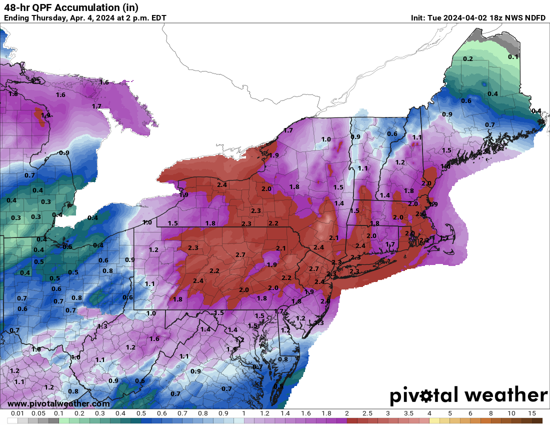
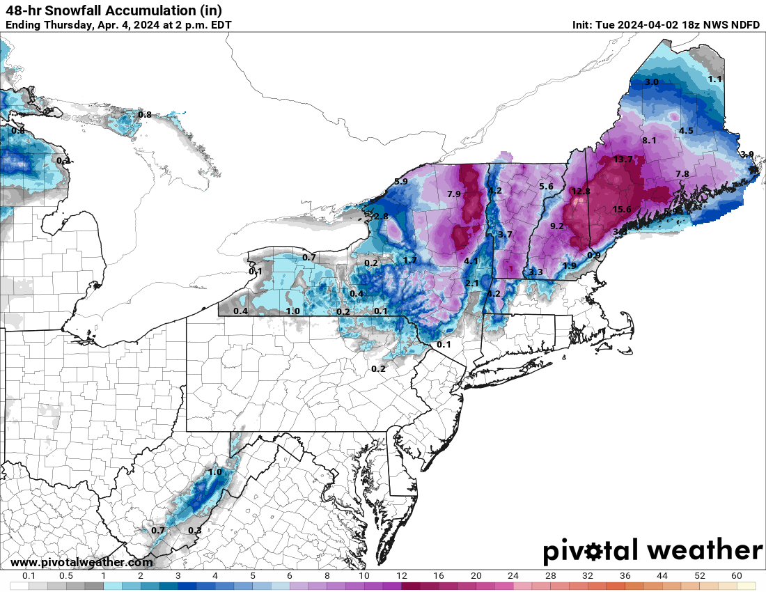
People seemed disappointed I didn't do a thread for the last rainstorm, so here you go. For our area, this rainstorm will be somewhat similar to the one a week and a half ago with 2-3" of rain (locally up to 4") being likely for most of the region over the next 2+ days - the long time duration should prevent major flooding, although some minor (and isolated moderate) urban/stream flooding is likely. In addition, some minor coastal flooding is likely the next 2 days for the Jersey Shore and a wind advisory is up for coastal Middlesex/Monmouth/Ocean for gusts up to 50 mph. Gonna be a couple of raw days out there. The NWS page summarizes the various impacts from the rain well and the NWS 48 hr total precip and snowfall forecast maps are below.

https://www.weather.gov/phi/

With regard to the cold side, the chances of measurable snow Weds night/Thursday morning for the 95 corridor have dwindled to about nil (at best, some snow showers with no accumulation maybe early Thursday, but unlikely). However, the models are currently split on NW areas with some showing a few to maybe several inches of snow for the Poconos and NWNJ (Sussex/NW Warren/NW Passaic) and even up to 1" along 80 (W of 287), but with some showing only an inch or so of snow for the highest elevations in the Poconos/NW Sussex and no snow anywhere else. This could've been an epic snowstorm for many if there was a bit more cold air to work with and if the track was further SE. Stay tuned if in a NW area.

But for the Catskills and much of interior NY and New England, particularly at higher elevations, it's looking like another snowstorm with watches up for 6" or more of snow and some sleet/freezing rain for the Catskills and ski resorts in central New England and 12-18" or so for the far northern ski areas in the Adirondacks and New England. Spring skiing has turned out to be pretty good for many. And by the way, they're getting hammered with a foot or more of snow in much of WI and northern MI.

mMCMZtU.png


KxXXCmd.png

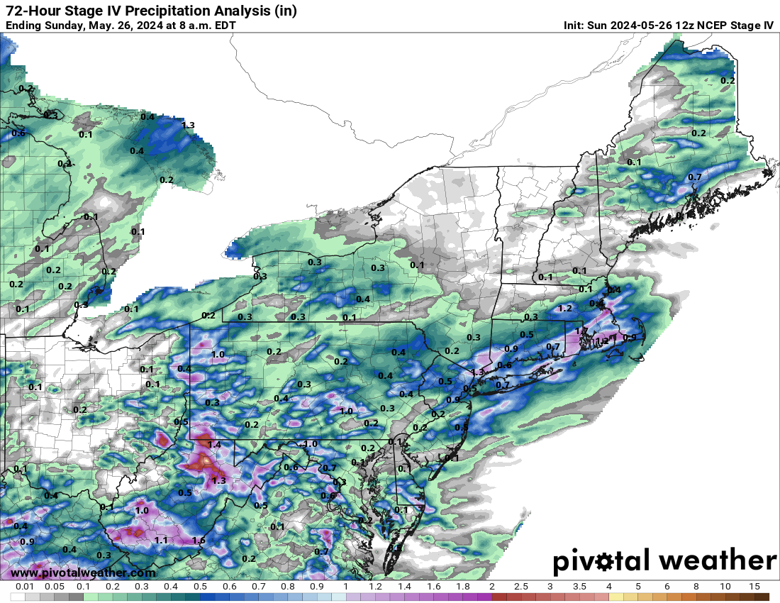
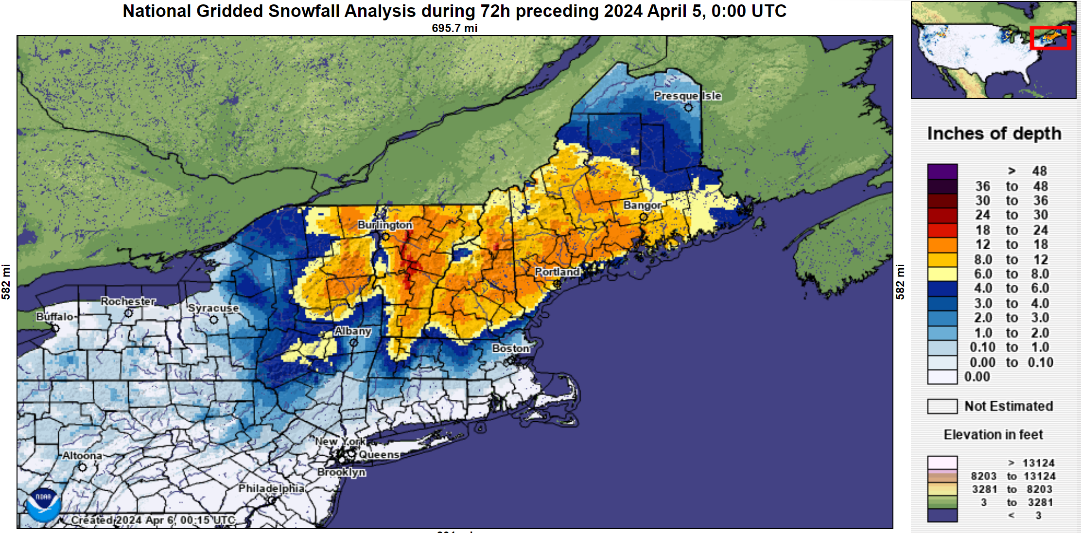
Pretty good NWS snow and precip forecasts, at least in the big picture - there will always be areas that are missed though. The NWS had increased snowfall forecasts for most of NY/VT/NH/ME before the storm, too, so the differences were smaller vs. what fell. And the rainfall forecasts for our area were generally pretty good. At least I'll get to see some decent snowpack in northern New England on our eclipse trek, although I assume a decent amount will melt before we get there Sunday afternoon.

stageiv_qpe_072h_p.us_ne.png


H8GN38f.png
 
ADVERTISEMENT
ADVERTISEMENT