
Airport conditions at EWR should be fine by 10 am or so, when temps go above freezing, but it's hard to predict any residual delays from earlier in the morning. I would think airports should be able to keep runways/planes snow/ice free and not have too many issues, mostly assuming only 1-2" of snow/sleet, although the freezing rain is a bit of a wild card.I’m supposed to land in Newark about 4:00pm tomorrow.
United is already posting about delays& cancellations and giving notice to change travel plans.
Hopefully by then the System has moved on and the airport gets back to normal operations.
Colleges
- American Athletic
- Atlantic Coast
- Big 12
- Big East
- Big Ten
- Colonial
- Conference USA
- Independents (FBS)
- Junior College
- Mountain West
- Northeast
- Pac-12
- Patriot League
- Pioneer League
- Southeastern
- Sun Belt
- Army
- Charlotte
- East Carolina
- Florida Atlantic
- Memphis
- Navy
- North Texas
- Rice
- South Florida
- Temple
- Tulane
- Tulsa
- UAB
- UTSA
- Boston College
- California
- Clemson
- Duke
- Florida State
- Georgia Tech
- Louisville
- Miami (FL)
- North Carolina
- North Carolina State
- Pittsburgh
- Southern Methodist
- Stanford
- Syracuse
- Virginia
- Virginia Tech
- Wake Forest
- Arizona
- Arizona State
- Baylor
- Brigham Young
- Cincinnati
- Colorado
- Houston
- Iowa State
- Kansas
- Kansas State
- Oklahoma State
- TCU
- Texas Tech
- UCF
- Utah
- West Virginia
- Illinois
- Indiana
- Iowa
- Maryland
- Michigan
- Michigan State
- Minnesota
- Nebraska
- Northwestern
- Ohio State
- Oregon
- Penn State
- Purdue
- Rutgers
- UCLA
- USC
- Washington
- Wisconsin
High Schools
- Illinois HS Sports
- Indiana HS Sports
- Iowa HS Sports
- Kansas HS Sports
- Michigan HS Sports
- Minnesota HS Sports
- Missouri HS Sports
- Nebraska HS Sports
- Oklahoma HS Sports
- Texas HS Hoops
- Texas HS Sports
- Wisconsin HS Sports
- Cincinnati HS Sports
- Delaware
- Maryland HS Sports
- New Jersey HS Hoops
- New Jersey HS Sports
- NYC HS Hoops
- Ohio HS Sports
- Pennsylvania HS Sports
- Virginia HS Sports
- West Virginia HS Sports
ADVERTISEMENT
You are using an out of date browser. It may not display this or other websites correctly.
You should upgrade or use an alternative browser.
You should upgrade or use an alternative browser.
OT: Wintry Mix Thursday (2/6) after 1 am: some snow/sleet through 6-8 am, then a bit of freezing rain (esp NW of 95) then rain likely until ~12 pm
- Thread starter RU848789
- Start date

The NWS in both Philly and NYC expanded their advisories to just about their entire forecast areas, largely for a freezing rain risk of up to 0.1". Snowfall amounts were bumped up slightly from 4 pm, with a wider area in their 1-2" blue swath (which is largely 1-1.5" based on their point-and-click hourly graphics), including all of NENJ/NYC metro.


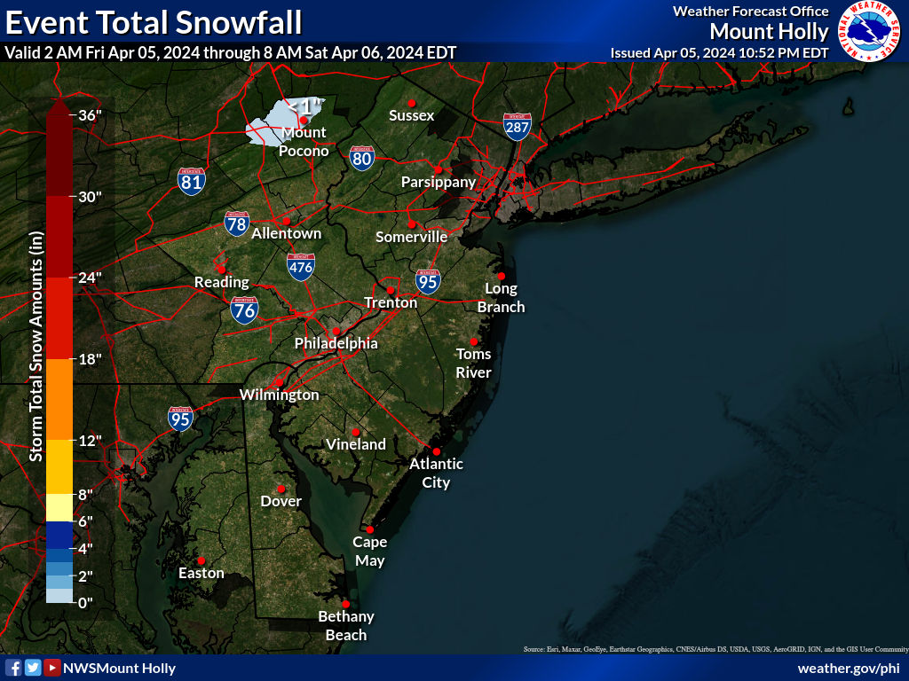
The NWS made a more substantial snowfall map update, below, about 30 minutes ago, bumping up amounts so that all of CNJ and adjacent EPA, along/N of 276/195 are in the 1-2" darker blue swath, as is all of NENJ/NYC and most of LI. Note that the point/click forecasts show about 1.2-1.6" of snow/sleet for most locations in the darker blue. The NWS also updated their freezing rain ice accretion map, below. It shows simply 0.01-0.10" of freezing rain, but they have a more detailed map (not included below) showing ice in the 0.02-0.04" range for 95 and SE of there towards the coast, but the advisories state up to 0.1" possible for these locations, as the NWS knows it would only take a minor change to get to those levels.
Bottom line is that it's going to be a messy/icy overnight after midnight tonight (when precip starts) through at least the morning rush hour for almost everyone with temps going above 32F for the 95 corridor and SE of there between 7 am (coast) and 10 am (95). Treated roads will likely be fine, but untreated roads will be covered with snow/sleet, as temps will be in the upper 20s when the precip begins, and then some freezing rain on top of that will make things worse, before the changeover to rain. Be careful out there folks.


Thanks much.Airport conditions at EWR should be fine by 10 am or so, when temps go above freezing, but it's hard to predict any residual delays from earlier in the morning. I would think airports should be able to keep runways/planes snow/ice free and not have too many issues, mostly assuming only 1-2" of snow/sleet, although the freezing rain is a bit of a wild card.
Hoping the system can “move through quicker “ so roads , airports, etc. can be restored earlier.
The biggest change from last nights forecast on local Philly news to right now on 6ABC on their 10 AM run they are saying it could be done by 11am.Thanks much.
Hoping the system can “move through quicker “ so roads , airports, etc. can be restored earlier.
yes this isnt a long duration event...not likely to get started til 2-3 AM for most and out by noon if not 10 or 11 for some.
So you have an 8 hour window of time for a storm with snow at lighter rates at the start and will there be enough of a thump of any heavier rates before changing to sleet and freezing rain to put down any substantial accumulations of snow beyond an inch or so.....many times the sleet comes in right away but there are times then snow/sleet persists longer than expected and thats the uncertainty here...then you have the freezing rain which probably will be happening during rush hour. So messy commute because of the timing but conditions should improved rapidly in the afternoon
some models are more frozen like the rgem and the very aggressive hrrr which puts 4 inch totals of frozen out but both NAMs are actually very benign for tomorrow. Even the gfs really is only 1-1.5 of frozen across central jersey
As usual location location location...the usual suspects to the north know what you are in for..those to the south and shore have been through this and those in the central its always the middle ground that could go either way.
12Z models are in and are snowier and a bit wetter, in general. Tough forecast. Could see the NWS maybe bumping the initial snowfall thump up a little bit, but maybe not, as perhaps they have confidence in the warm air aloft coming in sooner, holding down snow/sleet amounts to the 1-2" forecast for most N of 276/195. We'll see.
- For the global models, the Euro and CMC are both about 2-4" for folks N of 276/195 (and 1-2" south of there for Philly and northern SNJ), UK is 3-5" for the whole Philly-NJ-NYC region, while the GFS is 1-2" along/N of 276/195, but 2-4" for NENJ/NYC.
- For the meso/short-term models, the HRRR and RAP are very bullish, still, with 3-5" for the entire region (a bit less for far SNJ), the RGEM shows 2-3" N of 276/195 (1" or so south of there)
- The NAM and NAM 3km are huge outliers showing <1" south of 80, with a bit of freezing rain, but mostly rain falling (1/4-1/2") and 1-2" of snow to freezing rain and rain north of there. Hard to take them too seriously given how much of an outlier they are - would be a huge coup if they were right.
- Almost all of the models showing a few inches or more of snow above do eventually show a changeover to sleet and rain (1/4" or more as temps go above freezing in the mid/late morning for most) with some showing a brief transition featuring freezing rain first, especially along/NW of 95
Any change to the start time for those who will be going to the basketball game?
Heading from South Jersey, so curious what it may be like between 11pm - 12pm.
Heading from South Jersey, so curious what it may be like between 11pm - 12pm.
its possible you could encounter something around midnight down there but you should be okay, even if you do this would be very light snow at the start even in your parts. I wouldnt stay home because of a threat of an early startAny change to the start time for those who will be going to the basketball game?
Heading from South Jersey, so curious what it may be like between 11pm - 12pm.
Unless it's in a glass with boozeThe freezing rain/rain line are in the Smyrna DE area around 7am when I normally leave for work so I might just call in to say i'll be 1-2 hours late. Ice is nothing to play with....
the NAMs refuse to budge as they want to make this basically a non event for everyone. the latest hrrs and rap are a bit less bullish than earlier runs
NJZ010-012-013-015-017>020-027-PAZ070-071-104-106-060815-
/O.CON.KPHI.WW.Y.0006.250206T0400Z-250206T1500Z/
Somerset-Middlesex-Western Monmouth-Mercer-Gloucester-Camden-
Northwestern Burlington-Ocean-Southeastern Burlington-Delaware-
Philadelphia-Eastern Montgomery-Lower Bucks-
Including the cities of Morrisville, Freehold, Glassboro,
Trenton, Lansdale, Cherry Hill, Somerville, Philadelphia, Media,
Doylestown, Norristown, Mount Holly, Jackson, Moorestown, Wharton
State Forest, New Brunswick, and Camden
208 PM EST Wed Feb 5 2025
...WINTER WEATHER ADVISORY REMAINS IN EFFECT FROM 11 PM THIS EVENING
TO 10 AM EST THURSDAY...
* WHAT...Mixed precipitation expected. Total snow and sleet
accumulations up to one inch and ice accumulations around one
tenth of an inch.
* WHERE...Portions of central, northern, and southern New Jersey and
southeast Pennsylvania.
* WHEN...From 11 PM this evening to 10 AM EST Thursday.
* IMPACTS...Plan on slippery road conditions. The hazardous
conditions could impact the Thursday morning commute.
PRECAUTIONARY/PREPAREDNESS ACTIONS...
Slow down and use caution while traveling. The latest road
conditions for the state you are calling from can be obtained by
calling 5 1 1.
The NWS made a more substantial snowfall map update, below, about 30 minutes ago, bumping up amounts so that all of CNJ and adjacent EPA, along/N of 276/195 are in the 1-2" darker blue swath, as is all of NENJ/NYC and most of LI. Note that the point/click forecasts show about 1.2-1.6" of snow/sleet for most locations in the darker blue. The NWS also updated their freezing rain ice accretion map, below. It shows simply 0.01-0.10" of freezing rain, but they have a more detailed map (not included below) showing ice in the 0.02-0.04" range for 95 and SE of there towards the coast, but the advisories state up to 0.1" possible for these locations, as the NWS knows it would only take a minor change to get to those levels.
Bottom line is that it's going to be a messy/icy overnight after midnight tonight (when precip starts) through at least the morning rush hour for almost everyone with temps going above 32F for the 95 corridor and SE of there between 7 am (coast) and 10 am (95). Treated roads will likely be fine, but untreated roads will be covered with snow/sleet, as temps will be in the upper 20s when the precip begins, and then some freezing rain on top of that will make things worse, before the changeover to rain. Be careful out there folks.
Bottom line: probably a good idea to stay off the roads between 3 am and 8-9 am for everyone in the region as this is the period of heaviest frozen precip, especially south of 78; with temps <32F for just about everyone (especially N of 276/195), any snow/sleet or freezing rain will accumulate easily on untreated surfaces. North of 78, roads might still be icy until late morning or noon. Also, zero precip before midnight so no impact on the hoops game.
Latest NWS maps below for snow and freezing rain - not much change since this morning, other than to extend the 1" line southward from about 276/195 to a line from Philly to LBI. If the NWS is right, expect a general 1-2" snowfall between Philly-LBI and 78 with the 1" amounts likely south of 276/195 to Philly-LBI and <1" south of the Philly-LBI line (precip will change to sleet/freezing rain earlier there) and closer to 2" near 78 and anywhere north of 78, including the rest of NNJ, NEPA, and NYC/western LI/Hudson Valley.
Also, the advisories are still up for everyone, largely due to the risk of up to 0.1" of freezing rain along/SE of 95 and up to 0.2" of freezing rain NW of 95 in PA/NJ, although most models are showing little to no ice along SE of 95, but it only takes a glaze of 0.02-0.04" to make things very slippery on untreated surfaces and that's what is forecasted along and SE of 95 in NJ. Once the transition to freezing rain occurs (assuming it does), the transition to plain rain should happen quickly, likely by 8-10 am for everyone along/S of 78 and an hour or two later N of 80 and well NW of 95 as temps go into the mid/upper 30s.
Note that most of the 12Z and 18Z models are showing 1-3" or 2-4" (except the NAM showing <1" still), but I think the NWS is counting on a changeover to sleet to keep snow depth down. If we get a decent burst of snow from about 4 am to 8 am as many models show, without changing over, those 2-4" amounts could be realized even in CNJ, but it's more likely that sleet mixes in and keeps the snowfall amounts under 2" for just about everyone except folks north of 78 and especially 80, where mixing will likely be delayed. This is why several models and and some forecasters (including Lee Goldberg) are calling for up to 3" north of 78.
https://www.weather.gov/phi


Last edited:
Most did a bit, except the Euro and UK.tonights models all cut back on snow totals..lets see what happens
Snow/sleet mix here at 30F with about 1/4" of snow/sleet on the ground as of 5:30 am. Radar looks juicy. Wasn't supposed to be sleet yet. If we've already had a permanent changeover that's way early and means we're likely not going to get more than 1/2" or so of sleet (~1.5" of snow "equivalent" by mass). Sleet being reported in most CNJ locations from what I've seen. NAM for the win, if so, and a significant forecast bust IMO, as the changeover to sleet wasn't supposed to occur until 7-8 am. I wonder if this also means we might get more freezing rain than expected, which would suck.
Everything is coated with a very slippery layer of snow/sleet and any untreated surfaces are treacherous; even the brined road we live on is very slippery. As I've said countless times, when it comes to impacts on travel and removal, frozen mass is way more important than depth (except for visibility impacts which are nil for sleet); also, sleet melts more slowly than snow once temps go above 32F, given the much lower surface area to volume/mass ratio (less surface area is exposed to warmer air per unit mass). Up to 31F now and worried about freezing rain coming, although still a mixture of maybe 80% sleet/20% snow.
Last edited:
Temps in Philadelphia have already hit 32 and 6ABC meteorologist was surprised it was this early. If there was any snow overnight there is no sign of it. Can hear sleet every once in awhile but just rain now in Belmont Hills Montgomery County.
Sleet with freezing rain. Models were onto less snow last night and the NAMs did better than those global and gfs. All the models cut back on qpf
Is it really a bust when they were generally forecasting about an inch or less..even in the nws text product
Seen these sleet events in my times
That said it's still will be slick and tough going for a couple hours for cj and more to the north so use caution
Is it really a bust when they were generally forecasting about an inch or less..even in the nws text product
Seen these sleet events in my times
That said it's still will be slick and tough going for a couple hours for cj and more to the north so use caution
Still 31F here with sleet falling and about 0.3-0.4" on the ground. Paved surfaces are very slippery. Got a very nice shout-out from Walt Drag on AmericanWx (former NWS Boston and Philly met - one of the best who posts a ton on weather now that he's retired) for my discussion of the impacts of sleet. It might not "look" bad out there, but numerous accidents being reported.
Can't call it a bust as it wasn't a big deal to begin with except the chance of sleet/ice.Sleet with freezing rain. Models were onto less snow last night and the NAMs did better than those global and gfs. All the models cut back on qpf
Is it really a bust when they were generally forecasting about an inch or less..even in the nws text product
Seen these sleet events in my times
That said it's still will be slick and tough going for a couple hours for cj and more to the north so use caution
It has underperformed where Im at as snow didn't show up. They did forecast it will be a fast exit and they are sticking to it.
With that said it looks like people didn't think to drive slower as there are many reported accidents including multiple ones on the NJ Turnpike.
The sexy Milfs aren't going to be happy!Hillsborough Deli just called for delayed opening 10 am
It's a bust, IMO vs. predictions of 1-2" of snow by the NWS and most forecasters and the many models showing 1-2" to 2-4" of snow. The NAM was the only one really showing <1" of snow due to an earlier changeover to sleet. This can be seen in the 0Z run last night, where the Pivotal snowmap shows <0.5" of snow, but the Tropical Tidbits map was showing ~2" of "snow" for much of CNJ - but on TT, sleet is reported as 10:! ratio snow by the model, whereas Pivotal doesn't count sleet at all. 2" of sleet would be about 2/3" of "snow" on the ground given about a 3:1 sleet:liquid ratio.Sleet with freezing rain. Models were onto less snow last night and the NAMs did better than those global and gfs. All the models cut back on qpf
Is it really a bust when they were generally forecasting about an inch or less..even in the nws text product
Seen these sleet events in my times
That said it's still will be slick and tough going for a couple hours for cj and more to the north so use caution
I had questioned some mets last night on-line about whether the NAM could be right and noticed you had also on AmericanWx, but didn't get much feedback on that other than it being an outlier, which was obvious - big coup for the NAM, which, sadly is going to be discontinued in the next year or two supposedly. It's not a great model, but it often does well in mixed precip events.
It's not a bust, IMO, however, with regard to impacts as sleet is just as difficult to drive/walk on as snow (maybe worse) and there are many, many accidents being reported. Let's see if we get freezing rain soon or just rain.


I don't think it's a bust
No one thought we were getting 2 inches of snow
Clown maps generally useless during an event like this
Tropical tidbits is horrible..why would you post that when pivotal more accurate
Even the nws maps stated 1 inch for most
The sleet signal was strong and models in the late stages were cutting snow amounts..even the hrrr rap hwr
Walt drag even told you this wasn't a bust
Last edited:
Up to 32F but still sleeting with some freezing rain mixed in with 0.4" of mostly sleet on the ground. Looks like this is about over for us, as temps are above 32F to my S/SE/E and even NE. Temps still 30F or less from about New Hope to Somerville to Madison and NW of that line, so more frozen to go there.
Good decision. It was a mess in the Trenton area early. *edit* It's better to wait for the frozen precip to pass before hauling everyone into the office.State offices have delayed opening until 11am
Last edited:
Are you just trolling? NWS had all of CNJ in the 1-2" swath and your and my point and click forecasts were for about 1.3" of snow which is clearly within 1-2". Many forecasters had us in 1-2" of snow. Also, I posted the two versions of the NAM to illustrate that by inference, the NAM forecast was for 2" of "snow" as sleet which is 2/3" of frozen precip on the ground, which isn't too far off what we have, which is why the NAM won the forecast derby.I don't think it's a bust
No one thought we were getting 2 inches of snow
Clown maps generally useless during an event like this
Tropical tidbits is horrible..why would you post that when pivotal more accurate
Even the nws maps stated 1 inch for most
The sleet signal was strong and models in the late stages were cutting snow amounts..even the hurricane rap hwr
Walt drag even told you this wasn't a bust
And I said it was a snow vs. sleet forecast bust, not a bust for impact, which Walt and I agreed with. Here's what he said in reply to my discussion of why sleet is just as impactful on travel and removal as snow (maybe moreso, since it melts more slowly). Not too many get props from a legend like Walt.
"You're explanation is imo, excellent and why we do what we do for kind of improving traveling life, when travel is not necessary or can be delayed. We love the flakes but it's the frozen-freezing that is the problem. Well stated.
I'll addd while Im here... the NAM is the so called winner on less snow and more IP... but its not nil and if you're getting snow this morning its your win. Wantage NJj has had very little snow so far. We are 0.4" sleet and down to 21F at 630AM
Finally: maybe the city and Island are OK on roads... am not quite sure though I check Cams around CP. Feedback will be helpful.
But overall I think this advisory is a success... imperfect yes, but not worth mentioning BUST. We'll look at this later today to see what has occurred."
https://www.americanwx.com/bb/topic...-i84-corridor/?do=findComment&comment=7618610
I agree this is a bust for the snow predicted. The models and guidance were leading people to speculate whether we'd get an initial thump of snow, wall of snow to begin, etc that then gets a crust of ice on top to end it, before going all rain.Are you just trolling? NWS had all of CNJ in the 1-2" swath and your and my point and click forecasts were for about 1.3" of snow which is clearly within 1-2". Many forecasters had us in 1-2" of snow. Also, I posted the two versions of the NAM to illustrate that by inference, the NAM forecast was for 2" of "snow" as sleet which is 2/3" of frozen precip on the ground, which isn't too far off what we have, which is why the NAM won the forecast derby.
And I said it was a snow vs. sleet forecast bust, not a bust for impact, which Walt and I agreed with. Here's what he said in reply to my discussion of why sleet is just as impactful on travel and removal as snow (maybe moreso, since it melts more slowly). Not too many get props from a legend like Walt.
"You're explanation is imo, excellent and why we do what we do for kind of improving traveling life, when travel is not necessary or can be delayed. We love the flakes but it's the frozen-freezing that is the problem. Well stated.
I'll addd while Im here... the NAM is the so called winner on less snow and more IP... but its not nil and if you're getting snow this morning its your win. Wantage NJj has had very little snow so far. We are 0.4" sleet and down to 21F at 630AM
Finally: maybe the city and Island are OK on roads... am not quite sure though I check Cams around CP. Feedback will be helpful.
But overall I think this advisory is a success... imperfect yes, but not worth mentioning BUST. We'll look at this later today to see what has occurred."
https://www.americanwx.com/bb/topic...-i84-corridor/?do=findComment&comment=7618610
In reality the precip shield was all choppy, and was sleet & fzra from what I've seen. Even late last night around midnight, soundings were coming in from MD showing warm air aloft. In Trenton there was a brief switch over to snow around 5am but that didn't last. Now it is straight up 33 and rain. If you live north and east, that's what's coming.
Exactly not worth mentioning bustAre you just trolling? NWS had all of CNJ in the 1-2" swath and your and my point and click forecasts were for about 1.3" of snow which is clearly within 1-2". Many forecasters had us in 1-2" of snow. Also, I posted the two versions of the NAM to illustrate that by inference, the NAM forecast was for 2" of "snow" as sleet which is 2/3" of frozen precip on the ground, which isn't too far off what we have, which is why the NAM won the forecast derby.
And I said it was a snow vs. sleet forecast bust, not a bust for impact, which Walt and I agreed with. Here's what he said in reply to my discussion of why sleet is just as impactful on travel and removal as snow (maybe moreso, since it melts more slowly). Not too many get props from a legend like Walt.
"You're explanation is imo, excellent and why we do what we do for kind of improving traveling life, when travel is not necessary or can be delayed. We love the flakes but it's the frozen-freezing that is the problem. Well stated.
I'll addd while Im here... the NAM is the so called winner on less snow and more IP... but its not nil and if you're getting snow this morning its your win. Wantage NJj has had very little snow so far. We are 0.4" sleet and down to 21F at 630AM
Finally: maybe the city and Island are OK on roads... am not quite sure though I check Cams around CP. Feedback will be helpful.
But overall I think this advisory is a success... imperfect yes, but not worth mentioning BUST. We'll look at this later today to see what has occurred."
https://www.americanwx.com/bb/topic...-i84-corridor/?do=findComment&comment=7618610
No one was expecting 2 inches of snow
Those who know know
I kept telling you this..my advisory from afternoon kept saying up to an inch
The probability maps actually saying 10% chance of more than an inch
People paying attention knew this was likely more ice and rain than snow
Nws had to at least keep public aware on an event but they also weren't shifting 1 inch predictions downward that late in the game
Storm over for me and most of CNJ, at least; final measurement was 0.4" of mostly sleet, bringing my winter total up to 11.1". Temp up to 33F and is 33-35F along and SE of 95 with light rain falling and the radar looks like the worst of the precip is over, although we still might get another 0.1-0.2" of rain - and this is very likely still sleet or maybe freezing rain 15-20 miles NW of 95 (i.e., a Doylestown to Morristown to Mahwah line where it's still in the 30-32F range and further NW of there where it's in the upper 20s.Up to 32F but still sleeting with some freezing rain mixed in with 0.4" of mostly sleet on the ground. Looks like this is about over for us, as temps are above 32F to my S/SE/E and even NE. Temps still 30F or less from about New Hope to Somerville to Madison and NW of that line, so more frozen to go there.
🙄 depends on where you live. The schools in the southern half of the state are on a delayed opening or remote learning schedule.Schools closed.
I was hoping for more rain just to clean everything up plus we need the rain. Was just outside. Can hardly see anything on the ground but you certainly hear the crunch of sleet underfoot.Storm over for me and most of CNJ, at least; final measurement was 0.4" of mostly sleet, bringing my winter total up to 11.1". Temp up to 33F and is 33-35F along and SE of 95 with light rain falling and the radar looks like the worst of the precip is over, although we still might get another 0.1-0.2" of rain - and this is very likely still sleet or maybe freezing rain 15-20 miles NW of 95 (i.e., a Doylestown to Morristown to Mahwah line where it's still in the 30-32F range and further NW of there where it's in the upper 20s.
Already 34 in Philadelphia but no melting near me.
Similar threads
- Replies
- 33
- Views
- 2K
- Replies
- 5
- Views
- 620
ADVERTISEMENT
ADVERTISEMENT