
Colleges
- American Athletic
- Atlantic Coast
- Big 12
- Big East
- Big Ten
- Colonial
- Conference USA
- Independents (FBS)
- Junior College
- Mountain West
- Northeast
- Pac-12
- Patriot League
- Pioneer League
- Southeastern
- Sun Belt
- Army
- Charlotte
- East Carolina
- Florida Atlantic
- Memphis
- Navy
- North Texas
- Rice
- South Florida
- Temple
- Tulane
- Tulsa
- UAB
- UTSA
- Boston College
- California
- Clemson
- Duke
- Florida State
- Georgia Tech
- Louisville
- Miami (FL)
- North Carolina
- North Carolina State
- Pittsburgh
- Southern Methodist
- Stanford
- Syracuse
- Virginia
- Virginia Tech
- Wake Forest
- Arizona
- Arizona State
- Baylor
- Brigham Young
- Cincinnati
- Colorado
- Houston
- Iowa State
- Kansas
- Kansas State
- Oklahoma State
- TCU
- Texas Tech
- UCF
- Utah
- West Virginia
- Illinois
- Indiana
- Iowa
- Maryland
- Michigan
- Michigan State
- Minnesota
- Nebraska
- Northwestern
- Ohio State
- Oregon
- Penn State
- Purdue
- Rutgers
- UCLA
- USC
- Washington
- Wisconsin
High Schools
- Illinois HS Sports
- Indiana HS Sports
- Iowa HS Sports
- Kansas HS Sports
- Michigan HS Sports
- Minnesota HS Sports
- Missouri HS Sports
- Nebraska HS Sports
- Oklahoma HS Sports
- Texas HS Hoops
- Texas HS Sports
- Wisconsin HS Sports
- Cincinnati HS Sports
- Delaware
- Maryland HS Sports
- New Jersey HS Hoops
- New Jersey HS Sports
- NYC HS Hoops
- Ohio HS Sports
- Pennsylvania HS Sports
- Virginia HS Sports
- West Virginia HS Sports
ADVERTISEMENT
You are using an out of date browser. It may not display this or other websites correctly.
You should upgrade or use an alternative browser.
You should upgrade or use an alternative browser.
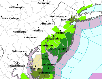
Minor to Moderate Snow Tues Night (2/11)/Weds Morning, especially south of 80 (all snow)
- Thread starter RU848789
- Start date
How many fouls does NWS have Somerville getting Wednesday nightSomerville inch on map you posted and I'm not far south of there
true dat homie, i may even crash the Melody ReunionYou had good comments and rationale for the separate thread. Now let's finish 7-0 and celebrate on the floor again like we did after the MD game in 2020! :>)

Get a roomappreciate you🤙
Was in a rush before and missed that the NWS had put SE Bucks, Mercer and Monmouth under advisories for 3-5", along with Ocean Burlington, Gloucester and Camden. That means if the storm overperforms a bit, 3+" could get up to 78 for Middlesex (3" is right along the SE border now) and maybe Somerset; Hunterdon might be too far west in that scenario.

Last edited:
Do it!! And @WhiteBus should attend also and a few others I'm sure...true dat homie, i may even crash the Melody Reunion
🌭Was in a rush before and missed that the NWS had put SE Bucks, Mercer and Monmouth under advisories for 3-5", along with Ocean Burlington, Gloucester and Camden. That means if the storm overperforms a bit, 3+" could get up to 78 for Middlesex (3" is right along the SE border now) and maybe Somerset; Hunterdon might be too far west in that scenario.
Similar threads
- Replies
- 472
- Views
- 19K
- Replies
- 74
- Views
- 2K
ADVERTISEMENT
Latest posts
-
-
FB Recruiting USC offers 2026 Rutgers commit Wydeek Collier....
- Latest: Christian0007
-
 FB Recruiting Georgia offers 2026 Rutgers commit Dyzier Carter....
- Latest: -RUFAN4LIFE-
-
ADVERTISEMENT