Colleges
- American Athletic
- Atlantic Coast
- Big 12
- Big East
- Big Ten
- Colonial
- Conference USA
- Independents (FBS)
- Junior College
- Mountain West
- Northeast
- Pac-12
- Patriot League
- Pioneer League
- Southeastern
- Sun Belt
- Army
- Charlotte
- East Carolina
- Florida Atlantic
- Memphis
- Navy
- North Texas
- Rice
- South Florida
- Temple
- Tulane
- Tulsa
- UAB
- UTSA
- Boston College
- California
- Clemson
- Duke
- Florida State
- Georgia Tech
- Louisville
- Miami (FL)
- North Carolina
- North Carolina State
- Pittsburgh
- Southern Methodist
- Stanford
- Syracuse
- Virginia
- Virginia Tech
- Wake Forest
- Arizona
- Arizona State
- Baylor
- Brigham Young
- Cincinnati
- Colorado
- Houston
- Iowa State
- Kansas
- Kansas State
- Oklahoma State
- TCU
- Texas Tech
- UCF
- Utah
- West Virginia
- Illinois
- Indiana
- Iowa
- Maryland
- Michigan
- Michigan State
- Minnesota
- Nebraska
- Northwestern
- Ohio State
- Oregon
- Penn State
- Purdue
- Rutgers
- UCLA
- USC
- Washington
- Wisconsin
High Schools
- Illinois HS Sports
- Indiana HS Sports
- Iowa HS Sports
- Kansas HS Sports
- Michigan HS Sports
- Minnesota HS Sports
- Missouri HS Sports
- Nebraska HS Sports
- Oklahoma HS Sports
- Texas HS Hoops
- Texas HS Sports
- Wisconsin HS Sports
- Cincinnati HS Sports
- Delaware
- Maryland HS Sports
- New Jersey HS Hoops
- New Jersey HS Sports
- NYC HS Hoops
- Ohio HS Sports
- Pennsylvania HS Sports
- Virginia HS Sports
- West Virginia HS Sports
ADVERTISEMENT
You are using an out of date browser. It may not display this or other websites correctly.
You should upgrade or use an alternative browser.
You should upgrade or use an alternative browser.
OT: Chance of a minor snowfall Thurs night/Fri am (3/3-4; go to end of thread)
- Thread starter RU848789
- Start date
Mr G on Pix11 is pretty good
Hes been retired for a couple of years now.
And the beat goes on..... golden sunshine until further notice. Then of course Katy Tong saying Thanks G.
Now I've seen it all:
People eating and drinking at Hoboken and JC's restaurants/bars outdoor cafe's in February. Gotta love it!
People eating and drinking at Hoboken and JC's restaurants/bars outdoor cafe's in February. Gotta love it!
Almost every model shows an inland solution now, from east of the Apps to friggin' Detroit, lol, except for the Canadian, which shows a track basically over NYC and gives a little front end snow to areas north of I-80, with a bit more north of I-84, but all rain south of 80 - the other models give all rain for the entire area and even up to Canada, with snows being pretty far west (Ohio). It would be a pretty epic reversal at this point to get snow for NJ, but I'll remain only 99% convinced until tomorrow night's models, which will include all the pieces of energy over land.
The primary storm Wednesday into Thursday is now pretty well modeled to be heading through the TN/OH Valleys towards the eastern Great Lakes, bringing heavy rains (1-2"), warm temps, and possibly high winds. No snow with that one for anyone east of the Apps, all the way up to Canada.
The first storm, Tuesday night into Wednesday, which is a pretty minor storm, is being modeled totally differently by some of the models. Most of the models show a relatively weak coastal low forming and bringing rain to just about everyone in our area, except for maybe up to an inch of snow in the far NW locations, like the Poconos, Sussex County and parts of the Hudson Valley.
Here's the interesting thing, though. The NAM (the one that nailed the blizzard) and the Canadian are showing a few inches of snow for all of north/central Jersey/eastern PA (and NYC/LI) as far south as 195/276 in NJ/PA for Tues night into Wednesday morning. Even if this occurred, temps would be borderline, but given that the precip would be at night, accumulations would be possible, even on untreated surfaces. Obviously, a low probability, but worth keeping an eye on, just in case these models are on to something.
http://forecast.weather.gov/product...&format=CI&version=1&glossary=1&highlight=off
TUESDAY AND TUESDAY NIGHT:
A WEAK AREA OF LOW PRESSURE WILL FORM ALONG A WARM FRONTAL BOUNDARY
LOCATED OVER THE CAROLINA COASTLINE. MOISTURE WILL ADVECT OVER
THE WARM FRONT AND WITH ENOUGH LIFT, LIGHT PRECIPITATION SHOULD
DEVELOP NORTH OF THE BOUNDARY AND MOVE INTO THE REGION ON TUESDAY.
TEMPERATURES WILL WARM INTO THE 40`S FOR MOST OF THE REGION ON
TUESDAY THANKS TO SOUTHERLY/SOUTHEASTERLY FLOW ON THE BACKSIDE OF
A DEPARTING HIGH PRESSURE SYSTEM. HOWEVER, ENOUGH COLD AIR MAY
LINGER ACROSS THE POCONOS AND NW NJ FOR SOME WINTRY PRECIPITATION.
ALSO, A WARM NOSE SEVERAL THOUSAND FEET ABOVE THE SURFACE WOULD
RESULT IN THE PRECIPITATION BEING A WINTRY MIX OF SNOW, SLEET AND
FREEZING RAIN THAT WOULD CHANGE TO RAIN BY WEDNESDAY MORNING.
TEMPERATURES WILL LIKELY NOT FALL MUCH TUESDAY NIGHT WITH THE
WARM AIR ADVECTION AND CLOUDS IN PLACE, WENT WARMER THAN MET/MAV
GUIDANCE WITH THE LOW TEMPERATURES OUTSIDE THE NORTHERN MOST PARTS
OF THE REGION WHERE COLD AIR IN THE LOW-LEVELS COULD LINGER
TUESDAY NIGHT. ACCUMULATIONS OF WINTRY PRECIPITATION STILL LOOK
LIGHT WITH UNDER AN INCH OF SNOW AND LESS THAN ONE-TENTH OF AN ICE
OF ICE FOR THE FOLLWING COUNTIES CARBON, MONROE PA AND SUSSEX NJ.
LITTLE OR NO ACCUMULATION EXPECTED ELSEWHERE.
WEDNESDAY THROUGH THURSDAY NIGHT: ANOTHER AREA OF LOW PRESSURE WILL
DEVELOP FURTHER WEST ALONG THE WARM FRONT ACROSS THE SOUTHERN
UNITED STATES WEDNESDAY AND STRENGTHEN AS IT MOVES NORTHEAST INTO
THE EASTERN GREAT LAKES ON THURSDAY. A STRONG COLD FRONTAL
BOUNDARY WILL MOVE THROUGH THE REGION AFTER THE LOW PASSES BY TO
OUR NORTHWEST. ADDITIONAL LIGHTER RAINFALL IS LIKELY ON WEDNESDAY
WITH SOME BREAKS BEFORE HEAVIER RAIN MOVES THROUGH AHEAD OF THE
COLD FRONTAL BOUNDARY WEDNESDAY NIGHT.
RAINFALL TOTALS WITH THE HEAVIER PERIOD OF RAIN WEDNESDAY NIGHT WITH
MODELED RAINFALL FROM 1 TO LOCALLY 2 INCHES ACROSS THE REGION.
THIS MAY RESULT IN SOME PONDING OF WATER ON ROADWAYS AND POOR
DRAINAGE FLOODING. THE MMEFS GUIDANCE SUGGESTS THE POTENTIAL FOR
MINOR RIVER FLOODING AS WELL IN A FEW LOCATIONS.
IN ADDITION TO THE HEAVY RAIN, WINDS WILL BE INCREASING AS THE LOW
PRESSURE STRENGTHEN TO OUR NORTHWEST. MODELED SOUDINGS SHOW THE
POTENTIAL FOR SUSTAINED WINDS AROUND 20 MPH AT TIMES THROUGH
THURSDAY WITH HIGHER GUSTS PERHAPS AS HIGH AS 35 MPH.
See my latest post - rain from the Weds/Thurs system for anyone east of the Apps (or Buffalo, really).Will it be rain or snow in Vermont? My brother has to travel in Southern Vermont on Wednesday.
Now I've seen it all:
People eating and drinking at Hoboken and JC's restaurants/bars outdoor cafe's in February. Gotta love it!
This morning, after our weekly soccer match, we had our post-game coffee/bagels at a local cafe, outdoors - was a great day day for soccer and relaxing outside...
While there's zero chance of snow with storm #2 on Weds/Thurs, given the track towards Buffalo, there's some non-zero chance of a few inches of front end snow with the weaker Tues night/Weds am system, as there will be marginal cold air in place and a favorable track along the coast. About an inch is forecast north of I-80 late Tuesday night and a coating to maybe 1/2" is forecast north of 78 by the NWS in NYC (but not by the NWS in Phillly, which has no snow south of 80).
Given that up to 1/2" of liquid equivalent is forecast for storm 1, it wouldn't take a giant shift in how much cold air arrives (and when) to give everyone north of maybe 195/276 in NJ/PA a couple of inches of snow, with maybe 2-4" north of 80. That's what the NAM continues to show. Is it just that crazy uncle, who is right once in awhile (like for the blizzard), but usually wrong? It certainly looks like it'll be wrong, but we'll see...
http://www.weather.gov/phi/winter
http://www.weather.gov/okx/winter
Someone should rent a snow machine and cover #'s yard with snow so when he wakes up Wed he be like a piggy in mud.
I've seriously considered buying a snow gun, lol. There's a guy on the weather boards in Midlothian, VA, (near Richmond) where they get a lot less snow than us, who has one and he always posts these crazy pics of all the snow on his property - the town kids love it.
certainly has been springish around these parts. 63, 56, and 53 the past 3 days IMBY..all temps which overperformed the forecasted highs. February will once again give us another above normal month temperature wise even with that awful albeit brief cold snap last weekend
Long range its looking like the weekend into the first week of March starts out on the chilly side normal to below normal with perhaps a chance of snow that first week in March. However looks like after that winter seems to be over as temps starting warming and the chances for snow start diminishing rapidly
Long range its looking like the weekend into the first week of March starts out on the chilly side normal to below normal with perhaps a chance of snow that first week in March. However looks like after that winter seems to be over as temps starting warming and the chances for snow start diminishing rapidly
Will likely be a bit of snow for you up in Wayne - areas to the north of I-80 can expect an inch or so of snow/sleet and then maybe a little freezing rain, especially to the N and W of the intersection of 80/287 in NJ/PA and north of 287 in NY. Winter weather advisories are up for the Poconos, Sussex/Warren/Morris, Western Bergen/Passaic and the Hudson Valley north of the Tappan Zee, for maybe 1-2" of snow, but moreso for the chance of a thin glaze (up to 0.1") of freezing rain, especially after dark (1-2" of snow does not warrant an advisory on its own - need 3" or more).Looks like the rain's coming in early.
Could even be a small accumulation (~1/2") of snow between 78 and 80 during the afternoon on colder surfaces, but unlikely to be any accumulations on paved surfaces during daylight hours with temps at or above 32F and the stronger late winter indirect sunlight. South of 78 it should be all rain, with at most a little mixed snow/sleet to at times, but no accumulation is expected. The heavy rains come tomorrow with temps in the 40s and potentially high winds and maybe even an unusual February thunderstorm or two.
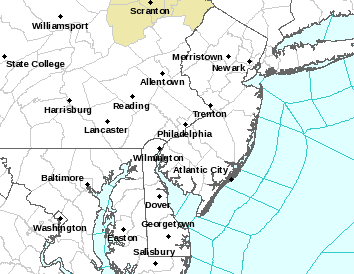
Interesting path for this second storm - it's basically going through the midwest and we're not getting much of it at all.
It's heading towards Cleveland, but we're going to get hammered with heavy rains, high winds and possibly even unusual February t-storms, as the moisture/energy levels associated with this storm are very high. The midwest is where all the snow will be on the NW side of the storm (from about Detroit on westward they're expecting up to a foot of snow and possible blizzard conditions - what we were in line for a week ago if the storm hadn't decided to cut well inland). Here's the latest discussion from the NWS in Philly...
.NEAR TERM /UNTIL 6 PM THIS EVENING/...
**DAMAGING WIND IS THE PRIMARY RISK LATE TODAY**
THIS MORNING...AREAS OF RAIN, DRIZZLE AND FOG. TEMPS RISING ABV
FREEZING IN THE HIGH TERRAIN OF SUSSEX AND MONROE COUNTIES SO HAVE
CANCELLED THE WXA.
OTHERWISE LCLLY DENSE FOG VCNTY KACY TO KDOV AND KILG WILL SHIFT
NORTHWEST THIS MORNING AND VSBYS WILL IMPROVE AS THE WIND TURNS
SOUTHEAST AND INCREASES BEHIND THE WARM FRONT. WILL COVER FOG WITH
AN SPS.
SCT HEAVY SHOWERS WILL DEVELOP NNEWD INTO PARTS OF THE AREA LATE
THIS MORNING AS PWAT INCREASES.
THIS AFTERNOON/EVENING: DAMAGING WIND IS THE MAIN STORY. ITS IN
THE FCST FOR THE DELMARVA. IT CAN LATER BE ADDED TO E PA AND NJ AS
CONFIDENCE FOR DAMAGING WIND OR A WATCH DICTATES.
KEY HERE...TEMPS 60-65F AND CONVECTION, ESPECIALLY IF ANY FOCUSED
FINE LINE, COULD GIVE 50-55KT GUSTS. SHERB, AS WELL SHEAR AND ML
CAPE ALL FAVORABLE FOR THE UNUSUAL FEBRUARY SITN.
NO WIND ADVY MOST OF THE AREA EXCEPT COASTAL NJ WHERE
COLLABORATED WITH OKX. MAY NEED TO EXPAND TO ALL OF THE DELMARVA.
NO FLOOD WATCH BUT AM EXPECTING 14 HR (12Z/24-04Z/25) TOTALS 1-2"
I95 REGION WESTWARD IN BEST LIFT WITH PWAT 1.4" AND STRONG NWD
MOISTURE TRANSPORT WITH 1 OR 2 BANDS OF TSTMS. WONT SURPRISE TO
NEED A COUPLE OF FLOOD WARNINGS ALONG I-95 CORRIDOR ISSUED
SOMETIME THIS EVENING.
TEMPS AND WINDS: DIFFICULT FCST BUT TRIED TO BLEND GFS/NAM MOS
AND 2M NAM WINDS/TEMPS WITH A DOUBLE CHECK AGAINST 00Z/24 ECMWF 2M
TEMPS/WINDS. ITS TIMING THE NWWD MOVING WARM FROPA.
&&
.SHORT TERM /6 PM THIS EVENING THROUGH 6 AM THURSDAY/...
LATE TONIGHT...SHOWERS GENERALLY END FM SW TO NE BETWEEN 03Z AND
06Z. WINDS DIMINISH BUT STILL QUITE MILD... LOWS TONIGHT 20F ABOVE
NORMAL.
The NWS National map actually kind of shows where the storm is headed - the track is east of where all the snow is expected. Those winter weather advisories for New England/NY are just for the next several hours until the warm air invades there, also. Temps are going to be in the 40s all the way up to Quebec City and it'll even turn to rain as far north as southern Newfoundland/Central Quebec.
http://www.weather.gov/

Last edited:
Man, just think of how much snow this would have been!
Don't remind me, lol. There's always March 3rd...
looks like that cold snap predicted for the end of the month next week will not happen. Looks like this is winters last hurrah. We could torch by the end of march....aw too bad.
That'd be a great birthday present for Tyler!Don't remind me, lol. There's always March 3rd...
Don't forget last year--while February and early March were brutally cold, we had a significant snowfall on March 20 after it had been mostly in the 50's for the prior two weeks.looks like that cold snap predicted for the end of the month next week will not happen. Looks like this is winters last hurrah. We could torch by the end of march....aw too bad.

sure it can snow but it becomes more of a thread the needle event the further we go and most of the time have trouble accumulating
last year was a neverending winter and the latest spring that I have ever seen...we were way behind the in the growing season...in the the el nino we are in an entirely different pattern
last year was a neverending winter and the latest spring that I have ever seen...we were way behind the in the growing season...in the the el nino we are in an entirely different pattern
Numbers you are asleep at the wheel...I guess a tornado watch for much of the area isn't worthy
that wicked line in PA about to enter the Jersey border
that wicked line in PA about to enter the Jersey border
Only moves the needle if it is a snownado.
Saw some pretty large lightning flashes a couple of hours ago.
Saw some pretty large lightning flashes a couple of hours ago.
Numbers you are asleep at the wheel...I guess a tornado watch for much of the area isn't worthy
that wicked line in PA about to enter the Jersey border
Monmouth Co under a tornado watch till 11pm
Numbers you are asleep at the wheel...I guess a tornado watch for much of the area isn't worthy
that wicked line in PA about to enter the Jersey border
Ugh this is gonna get worse tonight?
Saw that lightning, SE I'd Hudson County, earlier as well.
Numbers you are asleep at the wheel...I guess a tornado watch for much of the area isn't worthy
that wicked line in PA about to enter the Jersey border
You're really starting to act like a d-bag about the weather and I wish you'd stop. I was in meetings since lunchtime and then had a family dinner and just got back. Have had no time to look at weather info (but did give people a heads up on the severe potential late this morning) and no time to post since lunch and no ability to post since 5 pm (I do not have a smart phone).
The line of t-storms entering western parts of NJ from PA and along the Delaware from Wilmington to Trenton means business. Tornado watches are up, but tornadoes are very unlikely. Severe t-storms are much more likely and a warning for those is up right now for parts of SE PA and South Jersey between Trenton and Philly. Going to be some serious (but short-lived) storms for most of Central/North Jersey from now through about 11 pm (or midnight near the coast). Straight line winds are the biggest threat for damage.

Last edited:
3 downed wires calls in the 43rd (Sea Bright). My least favorite type of call.Monmouth Co under a tornado watch till 11pm
You're really starting to act like a d-bag about the weather and I wish you'd stop. I was in meetings since lunchtime and then had a family dinner and just got back. Have had no time to look at weather info (but did give people a heads up on the severe potential late this morning) and no time to post since lunch and no ability to post since 5 pm (I do not have a smart phone).
The line of t-storms entering western parts of NJ from PA and along the Delaware from Wilmington to Trenton means business. Tornado watches are up, but tornadoes are very unlikely. Severe t-storms are much more likely and a warning for those is up right now for parts of SE PA and South Jersey between Trenton and Philly. Going to be some serious (but short-lived) storms for most of Central/North Jersey from now through about 11 pm (or midnight near the coast). Straight line winds are the biggest threat for damage.

In addition to all the t-storm warnings and the tornado watch, the NWS just issued a short-fused flash flood warning for 1-1.5" of rain in these intense storms.
http://forecast.weather.gov/showsig...Warning&lat=40.5702&lon=-74.6104#.Vs53g_krIrg
BULLETIN - EAS ACTIVATION REQUESTED
FLASH FLOOD WARNING
NATIONAL WEATHER SERVICE MOUNT HOLLY NJ
1032 PM EST WED FEB 24 2016
THE NATIONAL WEATHER SERVICE IN MOUNT HOLLY NJ HAS ISSUED A
* FLASH FLOOD WARNING FOR...
MERCER COUNTY IN CENTRAL NEW JERSEY...
EASTERN HUNTERDON COUNTY IN NORTHWESTERN NEW JERSEY...
SOUTHEASTERN SUSSEX COUNTY IN NORTHWESTERN NEW JERSEY...
SOMERSET COUNTY IN NORTHERN NEW JERSEY...
MORRIS COUNTY IN NORTHERN NEW JERSEY...
WESTERN MIDDLESEX COUNTY IN NORTHERN NEW JERSEY...
NORTH CENTRAL BURLINGTON COUNTY IN SOUTHERN NEW JERSEY...
EAST CENTRAL BUCKS COUNTY IN SOUTHEASTERN PENNSYLVANIA...
* UNTIL 230 AM EST
* AT 1030 PM EST...A LINE OF THUNDERSTORMS WERE MOVING OVER THE SAME
AREA. DOPPLER RADAR INDICATED BETWEEN 1.00 AND 1.50 INCHES OF RAIN
WAS FALLING. THIS IS IN ADDITION TO THE HEAVY RAIN SOME AREAS
RECEIVED EARLIER. DUE TO SATURATED SOILS, EXCESSIVE RUNOFF WILL
OCCUR, AND QUICKLY. FLASH FLOODING IS EXPECTED ACROSS PORTIONS OF
THE WARNED AREA.
PRECAUTIONARY/PREPAREDNESS ACTIONS...
MOVE TO HIGHER GROUND NOW.
BE ESPECIALLY CAUTIOUS AT NIGHT WHEN IT IS HARDER TO RECOGNIZE THE
DANGERS OF FLOODING.
TURN AROUND...DON`T DROWN WHEN ENCOUNTERING FLOODED ROADS. MOST FLOOD DEATHS OCCUR IN VEHICLES.
Can't believe it's friggin' 65F at 11 pm on 2/24. That's what's fueling these rare February severe t-storms and worse to our south, where tornadoes hit. Not quite record warmth, but close...
So what's the latest on Tyler's birthday wish?That'd be a great birthday present for Tyler!Don't remind me, lol. There's always March 3rd...
So what's the latest on Tyler's birthday wish?
Potential late Thursday into Friday storm has generally shifted to our south in the latest models, meaning little to no impact, but the Canadian model still has a major snowstorm for many of us, while the Euro, which did have a good sized snowstorm, now shows a glancing blow to South Jersey, but isn't that far away from a decent storm.
Given that the energy for this storm is still well offshore in the Pacific (meaning a paucity of date for the model's initial conditions, which means error bars on the current models are quite high), it still bears watching. NWS has a nice discussion...
THEN ALL EYES TURN TO STORM OR NO STORM THU NIGHT INTO FRI. THE
06Z AND 12Z GFS HAS VIRTUALLY NO STORM FOR US. IT DEVELOPS SOME
SORT OF SYSTEM FURTHER S AND E OFF THE CONUS CST AND MOVES IT
HARMLESSLY OUT TO SEA.
THE ECMWF MAD A VERY PRONOUNCED SHIFT THIS MDL CYCLE. IT STILL
DEVELOPS A LOW ACRS THE SRN PLAINS ON THU, BUT IS HUNDREDS OF
MILES FURTHER S WITH THE POSN OF THE LOW THAN THE PREV RUN. THIS
IS MAINLY DUE TO THE HIGH TO THE N BEING STRONGER AND FURTHER S.THE
LOW THEN MOVES EWD AND EMERGES OFFSHORE OFF THE SC CST (VERSUS THE
DELMARVA CST IN THE PREV RUN). THE LOW THEN MOVES A BIT NE, BUT
THEN HEADS OUT TO SEA.
THE CURRENT ECMWF TRACK WOULD IMPLY IMPACTS MAINLY TO SRN
SECTIONS, MD, DE AND EXTREME SRN NJ AND PROBABLY NOT MUCH EVEN
THERE, AS QPF IS LOW. CLEARLY THIS STILL BEARS WATCHING AND
CONFIDENCE REMAINS LOW. IS THIS ONE ROGUE RUN OF THE ECMWF OR THE
START OF A TREND?
IT SHOULD BE NOTED THAT THE CMC STILL HAS A SOLN SIMILAR TO ITS
PREV RUN WITH A LOW IMPACTING MOST OF THE AREA.
BASED ON THE ECMWF AND GFS SOLNS HAVE LOWERED POPS ACRS THE
REGION. DID NOT WANT TO REMOVE THEM TOTALLY ATTM, JUST YET. IF THE
ECMWF TRACK IS CORRECT, THERE WOULD BE NO IMPACT IN NRN AREAS.
THERE IS STILL 5 DAYS TO SEE WHAT HAPPENS, BUT THIS IS A FAIRLY
SIGNIFICANT CHANGE, ESPECIALLY FOR THE ECMWF.
Dan Zarrow 101.5 FM. Snow Thursday night ending midday Friday with accumulations of up to an inch on grassy and cold surfaces.(sidewalks overpasses exit ramps) . Stay tuned.
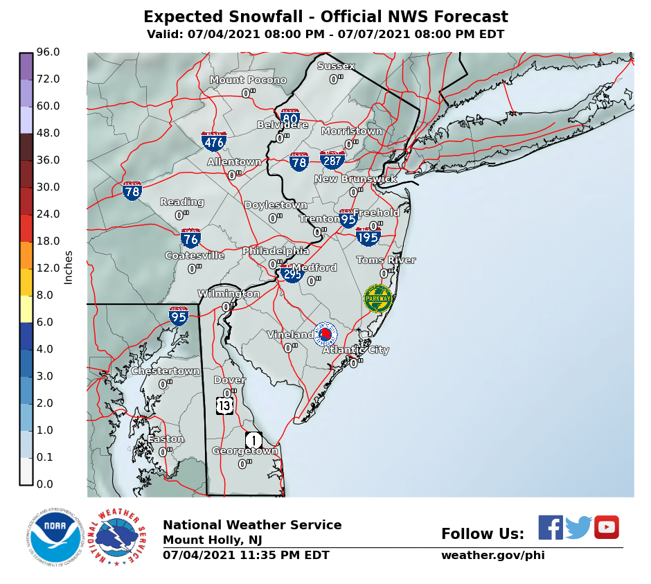
Looking like the approaching low from the west on Thursday night into Friday morning will bring some snow, especially south of 276/195 in PA/NJ, where an inch or two is possible (NWS map shows less, but some models show a bit more). At this point, a dusting to an inch is more likely between 276/195 and 78 and north of 78 might get shut out.
This initial low won't be that powerful, but whatever falls before rush hour on Friday will be snow and it will accumulate, as temps will be in the 20s, so the Friday morning rush hour could be impacted. Storm could still completely miss everyone north of Dover, DE to AC, but the storm could also bring a few inches to everyone if it shifts north. The secondary low that forms off the Carolinas is looking like it won't hit us, except maybe the immediate NJ coast and LI, but we're still about 3 days away from that part and things could still change on that.
We're barely into page 2 and this shouldn't be a big deal, so I don't see a need for a new thread yet, although I will change the title. If the models shift and a snowier solution is in the offing, which is still possible, as the main system is still off-shore in the Pacific (sparse data fed into the models, leading to uncertainty) until later tonight, I'll start a new thread (unless someone else does first).
http://www.weather.gov/phi/

[banana][banana][banana][banana][banana][banana][banana][banana][banana][banana][banana][banana][banana][banana][banana][banana][banana][banana][banana][banana][banana][banana][banana][banana][banana][banana]Looking like the approaching low from the west on Thursday night into Friday morning will bring some snow, especially south of 276/195 in PA/NJ, where an inch or two is possible (NWS map shows less, but some models show a bit more). At this point, a dusting to an inch is more likely between 276/195 and 78 and north of 78 might get shut out.
This initial low won't be that powerful, but whatever falls before rush hour on Friday will be snow and it will accumulate, as temps will be in the 20s, so the Friday morning rush hour could be impacted. Storm could still completely miss everyone north of Dover, DE to AC, but the storm could also bring a few inches to everyone if it shifts north. The secondary low that forms off the Carolinas is looking like it won't hit us, except maybe the immediate NJ coast and LI, but we're still about 3 days away from that part and things could still change on that.
We're barely into page 2 and this shouldn't be a big deal, so I don't see a need for a new thread yet, although I will change the title. If the models shift and a snowier solution is in the offing, which is still possible, as the main system is still off-shore in the Pacific (sparse data fed into the models, leading to uncertainty) until later tonight, I'll start a new thread (unless someone else does first).
http://www.weather.gov/phi/

Snow!
lol new thread...well that wont be needed this event may not even be cold enough to stick to pavement per Dan Zarrow
models are honking for springtime next week..I will probably start a new thead on that soon
models are honking for springtime next week..I will probably start a new thead on that soon
Similar threads
- Replies
- 131
- Views
- 5K
- Replies
- 74
- Views
- 2K
- Replies
- 19
- Views
- 784
- Replies
- 128
- Views
- 6K
ADVERTISEMENT
ADVERTISEMENT