Tacos huh?[laughing]Blizzard potential? I see tacos out edging and mulching today.
Colleges
- American Athletic
- Atlantic Coast
- Big 12
- Big East
- Big Ten
- Colonial
- Conference USA
- Independents (FBS)
- Junior College
- Mountain West
- Northeast
- Pac-12
- Patriot League
- Pioneer League
- Southeastern
- Sun Belt
- Army
- Charlotte
- East Carolina
- Florida Atlantic
- Memphis
- Navy
- North Texas
- Rice
- South Florida
- Temple
- Tulane
- Tulsa
- UAB
- UTSA
- Boston College
- California
- Clemson
- Duke
- Florida State
- Georgia Tech
- Louisville
- Miami (FL)
- North Carolina
- North Carolina State
- Pittsburgh
- Southern Methodist
- Stanford
- Syracuse
- Virginia
- Virginia Tech
- Wake Forest
- Arizona
- Arizona State
- Baylor
- Brigham Young
- Cincinnati
- Colorado
- Houston
- Iowa State
- Kansas
- Kansas State
- Oklahoma State
- TCU
- Texas Tech
- UCF
- Utah
- West Virginia
- Illinois
- Indiana
- Iowa
- Maryland
- Michigan
- Michigan State
- Minnesota
- Nebraska
- Northwestern
- Ohio State
- Oregon
- Penn State
- Purdue
- Rutgers
- UCLA
- USC
- Washington
- Wisconsin
High Schools
- Illinois HS Sports
- Indiana HS Sports
- Iowa HS Sports
- Kansas HS Sports
- Michigan HS Sports
- Minnesota HS Sports
- Missouri HS Sports
- Nebraska HS Sports
- Oklahoma HS Sports
- Texas HS Hoops
- Texas HS Sports
- Wisconsin HS Sports
- Cincinnati HS Sports
- Delaware
- Maryland HS Sports
- New Jersey HS Hoops
- New Jersey HS Sports
- NYC HS Hoops
- Ohio HS Sports
- Pennsylvania HS Sports
- Virginia HS Sports
- West Virginia HS Sports
ADVERTISEMENT
You are using an out of date browser. It may not display this or other websites correctly.
You should upgrade or use an alternative browser.
You should upgrade or use an alternative browser.
OT: Chance of a minor snowfall Thurs night/Fri am (3/3-4; go to end of thread)
- Thread starter RU848789
- Start date
lol new thread...well that wont be needed this event may not even be cold enough to stick to pavement per Dan Zarrow
models are honking for springtime next week..I will probably start a new thead on that soon
Dan Zarrow is a friggin' idiot if he's talking about it not being cold enough to stick. With temps below 32F on Thursday night until at least through rush hour Friday morning (reaching the mid-20s before dawn), any snow that falls will accumulate. Sure, any snow that falls after about 9 am on Friday, when the sun is up will have trouble accumulating in the early March indirect sunlight, but I think people will be far more concerned with conditions from 6-9 am on Friday. All of this is contingent upon us getting any snow, of course, but if it snows while it's dark, it'll stick.
I will say it slower this time....
NEW event (whatever it is) NEW thread.
NEW event (whatever it is) NEW thread.
That'll mess up getting pins in the greens numbers...I'm hoping no snow my friend.Dan Zarrow is a friggin' idiot if he's talking about it not being cold enough to stick. With temps below 32F on Thursday night until at least through rush hour Friday morning (reaching the mid-20s before dawn), any snow that falls will accumulate. Sure, any snow that falls after about 9 am on Friday, when the sun is up will have trouble accumulating in the early March indirect sunlight, but I think people will be far more concerned with conditions from 6-9 am on Friday. All of this is contingent upon us getting any snow, of course, but if it snows while it's dark, it'll stick.
Dan Zarrow is a friggin' idiot if he's talking about it not being cold enough to stick. With temps below 32F on Thursday night until at least through rush hour Friday morning (reaching the mid-20s before dawn), any snow that falls will accumulate. Sure, any snow that falls after about 9 am on Friday, when the sun is up will have trouble accumulating in the early March indirect sunlight, but I think people will be far more concerned with conditions from 6-9 am on Friday. All of this is contingent upon us getting any snow, of course, but if it snows while it's dark, it'll stick.
the storm we had in early Feb where I got 2 inches..it had major trouble sticking because of how light it was falling...the streets of Raritan and sidewalks required no cleanup..other colder surfaces fared better around the area as did the grass but I wouldn't be so quick to say he is wrong. We aren't getting heavy rates and its not going to be that cold...and its a big if about even getting any snow
I will say it slower this time....
NEW event (whatever it is) NEW thread.
meh aint worth it this time...this so called event more feeble than frightening
I will say it slower this time....
NEW event (whatever it is) NEW thread.
What? Speak up!

What really matters is the deliciously warm spell that models are indicating for next week...THAT is what matters!
GOLF IS UPON US
What really matters is the deliciously warm spell that models are indicating for next week...THAT is what matters!
Word
the storm we had in early Feb where I got 2 inches..it had major trouble sticking because of how light it was falling...the streets of Raritan and sidewalks required no cleanup..other colder surfaces fared better around the area as did the grass but I wouldn't be so quick to say he is wrong. We aren't getting heavy rates and its not going to be that cold...and its a big if about even getting any snow
bac - can you give me a date, if it wasn't the 2/5 storm (where I know you got 2" and we got 4")? Do you recall the temp? Was it snowing during daylight? Regardless, I can guarantee you that if it snows after dark on Thursday, with temps in the mid/upper 20s, even light snow will accumulate without any melting, except on treated surfaces, until 8-9 am Friday.
Last edited:
It's ALWAYS worth it.meh aint worth it this time...this so called event more feeble than frightening
These threads are like reading "The Big Bang Theory" [without the (.)(.)] instead of watching it.
GOLF IS UPON US
I got a new set of AP2's that need hittin.
bac - can you give me a date, if it wasn't the 2/5 storm (where I know you got 2" and we got 4")? Do you recall the temp? Was it snowing during daylight? Regardless, I can guarantee you that if it snows after dark on Thursday, with temps in the mid/upper 20s, even light snow will accumulate without any melting, except on treated surfaces, until 8-9 am Friday.
I believe it was 2/5...it accumulated from around 3-7AM but it got so light after that it was around 30/31 and it wasn't sticking anymore. Treated surfaces for some of our account had little or no snow, depends where we were. Grass had two inches in Belle mead but there was less snow..maybe 1-1.5 inches in Raritan even on grass
I believe it was 2/5...it accumulated from around 3-7AM but it got so light after that it was around 30/31 and it wasn't sticking anymore. Treated surfaces for some of our account had little or no snow, depends where we were. Grass had two inches in Belle mead but there was less snow..maybe 1-1.5 inches in Raritan even on grass
As I said to you on AmericanWx, the 2/5 storm was a completely different situation. We had rain and above freezing temps until the pre-dawn hours, when the rain changed to snow and it snowed at 31-32F for several hours, accumulating 2-5" on colder surfaces (2" at your house, 4" here and 3-5" most locations) and 1-2" on untreated paved surfaces, which were slightly warmer, such that poor accumulation was expected.
With this storm, temps should be in the mid/upper 20s from late evening until 7-8 am, meaning even light snow will easily accumulate, so if it snows during those hours, as is possible, untreated roads will be snow covered for the morning rush hour. Snow falling after about 8-9 am will have more trouble accumulating, in the indirect early March sunlight, i.e., light snow will barely accumulate, while moderate snow will accumulate (and snow is unlikely to be much more than light).
Models still iffy on us getting a few inches vs. no snow - tomorrow morning's runs will be the first ones with the system fully ashore, so that's when I'll really start paying attention.
Dan Zarrow 101.5FM.. " 1/2 to 1 inch of snow. Would I be surprised we get 2 inches? No. Would I be surprised to get a coasting? No. " Well that's how you cover yourself.
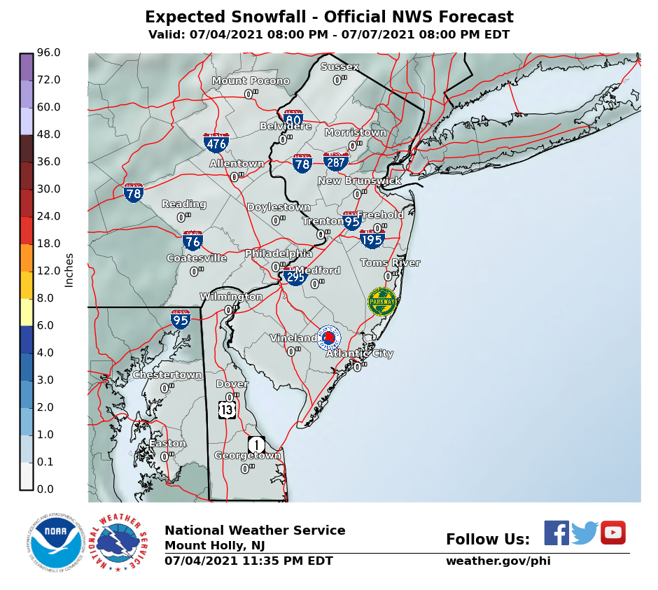
Still looking like a pretty minor event, although models have come closer with the storm track, so that a general 1-2" snowfall is now being predicted from late Thursday night through about lunch on Friday. Lesser amounts are likely well N/W and areas near the NJ coast and LI could get a little more. A complete miss is still possible and several inches of snow is still possible for most, although those two outcomes are looking very unlikely.Looking like the approaching low from the west on Thursday night into Friday morning will bring some snow, especially south of 276/195 in PA/NJ, where an inch or two is possible (NWS map shows less, but some models show a bit more). At this point, a dusting to an inch is more likely between 276/195 and 78 and north of 78 might get shut out.
This initial low won't be that powerful, but whatever falls before rush hour on Friday will be snow and it will accumulate, as temps will be in the 20s, so the Friday morning rush hour could be impacted. Storm could still completely miss everyone north of Dover, DE to AC, but the storm could also bring a few inches to everyone if it shifts north. The secondary low that forms off the Carolinas is looking like it won't hit us, except maybe the immediate NJ coast and LI, but we're still about 3 days away from that part and things could still change on that.
We're barely into page 2 and this shouldn't be a big deal, so I don't see a need for a new thread yet, although I will change the title. If the models shift and a snowier solution is in the offing, which is still possible, as the main system is still off-shore in the Pacific (sparse data fed into the models, leading to uncertainty) until later tonight, I'll start a new thread (unless someone else does first).
While 1-2" is clearly a minor event, the timing makes for a potentially impactful storm for the Friday morning rush hour, as temps will be in the mid/upper 20s for almost everyone while most of the snow is falling (roughly 10 pm Thursday till 10 am Friday) and any snow that falls before about 8 am (when the indirect sunlight will start to play a role in melting snow, even at 30-32F) will accumulate easily on all surfaces, except treated roads. We've seen many times when even just an inch of snow on a cold morning can cause traffic problems. Temps likely won't get above 32F until 10-11 am for most.

Schools closed and the MILFs at the Hillsborough Deli are getting themselves into a tizzy.
I think schools are likely open for this light snow event that wont stick to the treated roads
Still looking like a pretty minor event, although models have come closer with the storm track, so that a general 1-2" snowfall is now being predicted from late Thursday night through about lunch on Friday. Lesser amounts are likely well N/W and areas near the NJ coast and LI could get a little more. A complete miss is still possible and several inches of snow is still possible for most, although those two outcomes are looking very unlikely.
While 1-2" is clearly a minor event, the timing makes for a potentially impactful storm for the Friday morning rush hour, as temps will be in the mid/upper 20s for almost everyone while most of the snow is falling (roughly 10 pm Thursday till 10 am Friday) and any snow that falls before about 8 am (when the indirect sunlight will start to play a role in melting snow, even at 30-32F) will accumulate easily on all surfaces, except treated roads. We've seen many times when even just an inch of snow on a cold morning can cause traffic problems. Temps likely won't get above 32F until 10-11 am for most.
Very little change, really. Still looking at a general 1-2" snowfall for just about the entire region, i.e., all of NJ, eastern PA, DE, SE NY, NYC, LI and southern CT, as per the updated NWS maps, below. Still the potential for 3-5" from I-95 and points S/E of there if the track comes even 50-75 miles closer and still the potential for little to no snow (especially N/W of I-95) if the track moves 50-75 miles further out to sea.
However, 1-2" is a solid bet right now, with most of the snow falling before 8-9 am Friday and if that occurs, expect a slippery commute with temps below 32F through the night (28-31F mainly) and into the morning. Snow that falls after the sun is well up (after 8-9 am) will have a hard time accumulating with the indirect early March sun, especially since snowfall intensity is supposed to be fairly light and temps will rise into the middle 30s by noon.
Could be the last snow of the season, with temps likely to be in the 60s starting next Tuesday and possibly reaching the 70s mid/late next week. Once we get past about 3/20 snow is pretty rare, although we did get a general 3-6" snowfall in most of NJ last March 21st.


A
anon_ivydyf0amkzay
Guest
I keep seeing the snow total creeping up ever so slightly down the shore. Was <1, went to 1, now it is 2". This forecast is a grower.Very little change, really. Still looking at a general 1-2" snowfall for just about the entire region, i.e., all of NJ, eastern PA, DE, SE NY, NYC, LI and southern CT, as per the updated NWS maps, below. Still the potential for 3-5" from I-95 and points S/E of there if the track comes even 50-75 miles closer and still the potential for little to no snow (especially N/W of I-95) if the track moves 50-75 miles further out to sea.
However, 1-2" is a solid bet right now, with most of the snow falling before 8-9 am Friday and if that occurs, expect a slippery commute with temps below 32F through the night (28-31F mainly) and into the morning. Snow that falls after the sun is well up (after 8-9 am) will have a hard time accumulating with the indirect early March sun, especially since snowfall intensity is supposed to be fairly light and temps will rise into the middle 30s by noon.
Could be the last snow of the season, with temps likely to be in the 60s starting next Tuesday and possibly reaching the 70s mid/late next week. Once we get past about 3/20 snow is pretty rare, although we did get a general 3-6" snowfall in most of NJ last March 21st.


DT is saying 0.0 north of Philly to Toms River, so likely to be a close call, as usual...I keep seeing the snow total creeping up ever so slightly down the shore. Was <1, went to 1, now it is 2". This forecast is a grower.
https://www.facebook.com/WxRisk/
C'mon Spring! When will our first 70 degree day be?
Wednesday or Thursday
Interesting discussion from NWS-NYC on last night's models generally looking drier (less snowy), but they want to wait to see today's 12Z models (coming out soon) to see if that was a blip or a real change in how the storm is expected to go. If the trend persists, most folks north of I-78 will get nothing and most folks between 195 and 78 will get an inch or less.
http://forecast.weather.gov/product...&format=CI&version=1&glossary=1&highlight=off
IN TERMS OF SNOW AMOUNTS. 00Z DETERMINISTIC MODELS HAVE COME IN
NOTICEABLY DRIER...ECMWF/NAM/GEM GENERALLY OUTPUTTING A FEW
HUNDREDTHS TO A TENTH OF AN INCH QPF...WHILE GFS ABOUT 1 TO 2
TENTHS. LOWEST AMOUNTS MODELED ACROSS CT...WITH BATTLE BETWEEN
SUBSIDENCE FROM HIGH PRESSURE TO NE AND MOISTURE/LIFT AHEAD OF
SHORTWAVE. THIS SEEMS LIKE A REASONABLE SCENARIO...BUT WOULD LIKE TO
SEE SOME RUN TO RUN CONSISTENCY BEFORE FULLY MOVING IN THAT
DIRECTION. BASED ON SHAKY MODEL QPF PERFORMANCE WITH STORMS 24
HOURS OUT EARLIER THIS SEASON AND ABOVE MENTIONED ENSEMBLE
SPREAD...PREFER TO STAY CLOSE TO ENSEMBLE MEANS OF 1 TO 2 TENTHS
OF AN INCH QPF...HIGHEST AMOUNTS ACROSS NYC METRO AND LI.
THIS TRANSLATES TO A MOST LIKELY POTENTIAL OF 1 TO 3 INCHES OF
SNOW ACROSS THE REGION...HIGHEST AMOUNTS NYC AND LI...LOWEST
AMOUNTS ACROSS INTERIOR SOUTHERN CT. TWO LOWER PROBABILITY
SCENARIOS ARE: 1)A SLIGHT NORTHWARD JOG OF LOW PRESSURE WHICH
WOULD INCREASE SNOW TO ADVISORY LEVEL (2 TO 4 INCHES) ACROSS NYC
AND LI...AS WELL AS INCREASED WIND INTENSITY ACROSS COAST. 2) IF
SLIGHTLY FARTHER SOUTH AND DRIER DETERMINISTIC TRENDS
VERIFIES...ONLY TRACE TO 1 INCH AMOUNTS WOULD BE EXPERIENCED
ACROSS THE REGION.
some models are giving us nothing...this so called event which was never modeled to be much of anything looking more and more feeble. Todays GFS and Euro are its last hopes for resuscitation
Just going out to get a load of salt and calcium chloride. If I don't use it we'll have an ice cream party.
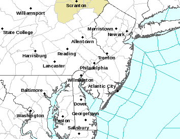
Most models showing an inch or less from Perth Amboy to New Hope up to about 78 and <1/2" from 78 to 80 and basically no snow north of 80. Could be 1-2" from 276/195 in PA/NJ up to Perth Amboy to New Hope. South of 276/195, roughly, where the criterion for an advisory is 2" of snow in 12 hours, winter weather advisories are up for 1-3" of snow. Maps in the posts above have been updated and show a little less than they did this morning. A complete whiff is still possible for anyone north of 276/195 and the worst case is probably 2-3" north of there.
Temps overnight should be 30-31F in most locations, so any falling snow should accumulate on untreated surfaces. Would be very surprised if any schools are cancelled - at most a delay until 10 am, when any snow on any pavement anywhere in the region should be mostly melted by the indirect sunlight and temps climbing into the mid-30s.
http://www.weather.gov/phi/

A
anon_ivydyf0amkzay
Guest
Only you can get away with that.40s Sunday, 50s Monday, 60s Tuesday, low 70s Wednesday...that's just fabulosity right there!!!
And Kyle Field is still eh. LOL
A
anon_ivydyf0amkzay
Guest
Only you can get away with that.
And Kyle Field is still eh. LOL
Bitch, please!!
That's even funnier!Bitch, please!!
Family doesn't know why I am laughing so hard. Good one!
$$$$$$$$$$$$$$$$$$$$$$$$Unfortunately, even without the snow, the road crews were putting that crap down on the roads today. Guess I'll have to wait until the next hard rain to take the SS out.
Similar threads
- Replies
- 223
- Views
- 8K
- Replies
- 87
- Views
- 4K
- Replies
- 33
- Views
- 2K
ADVERTISEMENT
ADVERTISEMENT
