
The wind has been S/SE almost all summer keeping the water cold. My car read 77 degrees in AP 2 blocks in from the beach. Another beautiful day at the beach.
Colleges
- American Athletic
- Atlantic Coast
- Big 12
- Big East
- Big Ten
- Colonial
- Conference USA
- Independents (FBS)
- Junior College
- Mountain West
- Northeast
- Pac-12
- Patriot League
- Pioneer League
- Southeastern
- Sun Belt
- Army
- Charlotte
- East Carolina
- Florida Atlantic
- Memphis
- Navy
- North Texas
- Rice
- South Florida
- Temple
- Tulane
- Tulsa
- UAB
- UTSA
- Boston College
- California
- Clemson
- Duke
- Florida State
- Georgia Tech
- Louisville
- Miami (FL)
- North Carolina
- North Carolina State
- Pittsburgh
- Southern Methodist
- Stanford
- Syracuse
- Virginia
- Virginia Tech
- Wake Forest
- Arizona
- Arizona State
- Baylor
- Brigham Young
- Cincinnati
- Colorado
- Houston
- Iowa State
- Kansas
- Kansas State
- Oklahoma State
- TCU
- Texas Tech
- UCF
- Utah
- West Virginia
- Illinois
- Indiana
- Iowa
- Maryland
- Michigan
- Michigan State
- Minnesota
- Nebraska
- Northwestern
- Ohio State
- Oregon
- Penn State
- Purdue
- Rutgers
- UCLA
- USC
- Washington
- Wisconsin
High Schools
- Illinois HS Sports
- Indiana HS Sports
- Iowa HS Sports
- Kansas HS Sports
- Michigan HS Sports
- Minnesota HS Sports
- Missouri HS Sports
- Nebraska HS Sports
- Oklahoma HS Sports
- Texas HS Hoops
- Texas HS Sports
- Wisconsin HS Sports
- Cincinnati HS Sports
- Delaware
- Maryland HS Sports
- New Jersey HS Hoops
- New Jersey HS Sports
- NYC HS Hoops
- Ohio HS Sports
- Pennsylvania HS Sports
- Virginia HS Sports
- West Virginia HS Sports
ADVERTISEMENT
You are using an out of date browser. It may not display this or other websites correctly.
You should upgrade or use an alternative browser.
You should upgrade or use an alternative browser.
OT: Big Heatwave/EDIT: Debbie passes well to west but band of showers and squall line and tornado watch to get thru
- Thread starter bac2therac
- Start date

Is this really news?? Similar to green heads being a problem on the beach when there is a West wind.Per NJ news 12:
The cold water was due to a process called upwelling, which occurs when strong winds from the south and southwest push warm water to the bottom of the ocean, causing cold water from the ocean floor to rise to the surface.
The map showed most of the NJ shoreline but Sandy Hook might be north enough to feel the avg temp in the low 70s.
It's like some people have never been to the beach consistently in NJ.
And they don't move the warm to the bottom. They move it North or offshore.
Last edited:
Today was deceptively hot at camp. Totally snuck up on the staff and we sent a bunch of them home with heat related illnesses. I'm always shocked when the parents send the kids in when it's going to be 100+ out. It's hard to keep them upright.
Camp? Still need the extra money? :)Today was deceptively hot at camp. Totally snuck up on the staff and we sent a bunch of them home with heat related illnesses. I'm always shocked when the parents send the kids in when it's going to be 100+ out. It's hard to keep them upright.
It’s still pretty clear, clouds to the west. I’m up on my roof deck and I had to get a sweatshirt it’s so chillyLooks like Cape May County is going to be nailed again tonight.
Your problems start at 11pmIt’s still pretty clear, clouds to the west. I’m up on my roof deck and I had to get a sweatshirt it’s so chilly
I’m already seeing lightning to the WestYour problems start at 11pm
Been pouring here for the last 30 minutes or so, but no reports of high winds in our area that I've seen - some high winds and downed trees reported elsewhere, though. Can't wait for the return to normal weather tomorrow.
Have friends at CitiField at the Foo Fighters show and they just stopped it for awhile presumably. Sucks.
Have friends at CitiField at the Foo Fighters show and they just stopped it for awhile presumably. Sucks.
Can we end this thread now and start a cold wave thread?Most of the state hasnt even hit 90 once yet despite an overall warmer than normal regime in May and the first half of June. Many of you will not realize how big the jump in temperature will wear on you after days and days of prolonged heat. There is still a question of where the hottest weather will be centered...its expected to possible be north of here in upstate NY and NE. NYC and eastern locations may not see the core of the heat and be more so in the low 90s. Mt Holly going very bullish with the high temps this week and they could be leaning into the dry conditions which only enhances our potential. Lawns already starting to dry out will turn to toasty browns and yellows by the weekend
Monday
Sunny, with a high near 91. Southwest wind 5 to 10 mph.
Monday Night
Mostly clear, with a low around 67. South wind around 5 mph.
Tuesday
Sunny and hot, with a high near 98. Southwest wind around 5 mph.
Tuesday Night
Mostly clear, with a low around 68.
Juneteenth
Mostly sunny and hot, with a high near 99.
Wednesday Night
Partly cloudy, with a low around 68.
Thursday
Mostly sunny and hot, with a high near 100.
Thursday Night
Partly cloudy, with a low around 70.
Friday
Mostly sunny and hot, with a high near 100.
Friday Night
Partly cloudy, with a low around 70.
Saturday
Mostly sunny and hot, with a high near 98.
Can we end this thread now and start a cold wave thread?
No.
Heat is gone for the next week although some may touch 90 on Sunday. 80s but with humidity and a lot of shower chances. Probably not the best of weeks coming up.
Heat may reload after next weekend
It's summer time, you know.No.
Heat is gone for the next week although some may touch 90 on Sunday. 80s but with humidity and a lot of shower chances. Probably not the best of weeks coming up.
Heat may reload after next weekend
It's summer time, you know.
Just less humidity and pollen would be a major improvement.
So temps dropped below 70° last night for the first time in almost 2 weeks. Also, we got an inch and an eighth of much needed rain from those storms last night.
I knew the general science but I found his last sentence informative:Is this really news?? Similar to green heads being a problem on the beach when there is a West wind.
It's like some people have never been to the beach consistently in NJ.
And they don't move the warm to the bottom. They move it North or offshore.
"The map showed most of the NJ shoreline but Sandy Hook might be north enough to feel the avg temp in the low 70s".
Sandy Hook curves west and because of that (I think) it doesn't get the same wave intensity as beaches just a coupe miles South. Maybe something like that is in play with the water temps.
I am so glad this heatwave is over...
Tuesday night's storm took out our power. PECO says up by Wed Afternoon, no big deal, just need to sweat through one night.
Wed afternoon power comes on around 3 or so, Great! Mother Nature say Nah! and another series of storms cranks through at 4 and takes out the power again. Finally got it back about an hour ago.
Can't wait to actually sleep through the night tonight.
It's glorious to walk outside for five minutes and not have your sack stick to the side of your leg.
It's glorious to walk outside for five minutes and not have your sack stick to the side of your leg.
Very eloquently put!
Is it possible to have 110-115 temp in NJ in a few years?
A few years? 110-115 actual? No.
DC was 106 yesterday.
Is that in Central NJ?
noIs it possible to have 110-115 temp in NJ in a few years?
much of NJ hasnt even hit 100 in 12 years....
DC was 106 yesterday.
DC is slightly warmer to begin with. That's a 90 year record for them going back to the 30's dust bowl and by only a degree or two. 4-9 degrees warmer in a few years would be unheard of.
Just got our new PSEG bill. My goodness. Highest bill ever by a large margin. LOL!
Today was great and just in time, as I was at an all afternoon BBQ in Rahway Park, DJ-ing for my old boss's group of ~200; it's fun going back and seeing a bunch of folks I used to work with. They had a great food truck and then an ice cream truck later on. Then got in a round of disc golf at Thompson Park in Jamesburg - first time in awhile I wasn't completely drenched after playing.
Weather looks great for the next week or so (mostly seasonable with tolerable humidity), although it'll warm up some in the 8-14 day timeframe, but it's unlikely to be as hot/humid as what we've been through.
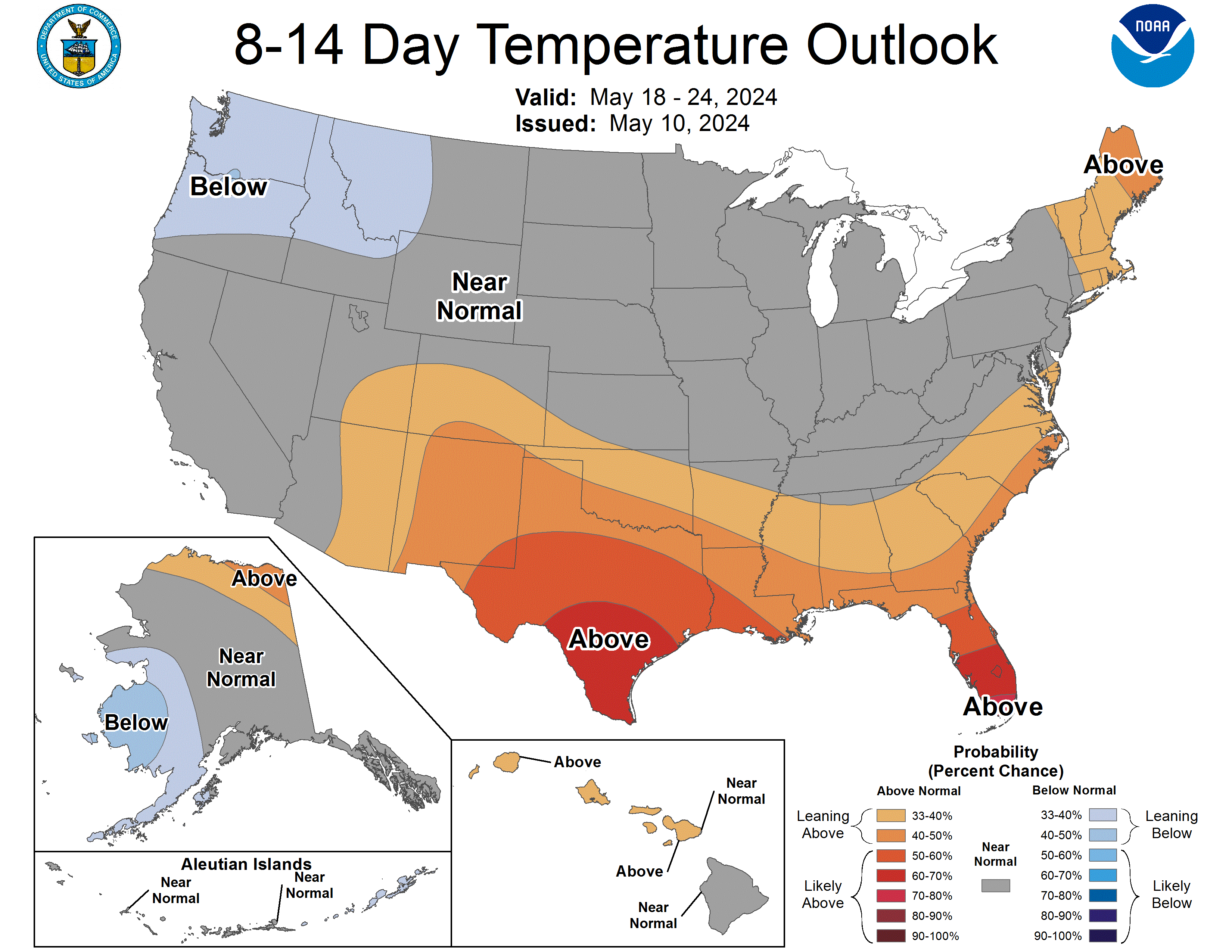
Weather looks great for the next week or so (mostly seasonable with tolerable humidity), although it'll warm up some in the 8-14 day timeframe, but it's unlikely to be as hot/humid as what we've been through.

That appears to be in a high emissions scenario (no change from the present?) and 60 years off. I don't think 60 years is a few years and I believe emissions in the US have been declining though not as fast as some advocates want.
Wait till next week. Round 3 or 4 coming and it's at least a week. Possibly 10+ 90 or higher days in PhillyI wrote a premature obituary to this thread - it's freaking nasty out there today.
Yes, it will likely be above 90F for highs in Philly starting on Sunday and through most/all of next week (but in the low 90s), but at least through mid next week, we're not going to be seeing the kind of elevated humidity and dewpoints we've seen in past heat waves (dewpoints should be in the mid/upper 60s not the low/mid 70s). The CPC is predicting much warmer than normal temps for the end of next week and the following weekend, although those forecasts aren't always correct 8-14 days out. NYC will be a few degrees cooler most days, so NYC might only see a few days above 90F.Wait till next week. Round 3 or 4 coming and it's at least a week. Possibly 10+ 90 or higher days in Philly
managed to begin a sneaky heatwave....#4 for me, not all in fact most of the state will not hit heatwave criteria until tomorrow or possibly later.
Sunday: 90
Monday: 92
Tuesday: 91
highs today will range from mids 80s to low 90s depending on how much sun one gets later this afternoon. Humidity levels remain high. Thursday looks to be the hottest of the week which highs in the mid 90s...low to mid 90s for Friday with more clouds mixing in and a small shower chance. Weekend looks iffy...showers and thunderstorms around but not even close to being pinpointed and it certainly will not be a washout but it also wont be as nice as last week...still should get some peaks of sun at times...highs will at least be in the upper 80s but could top 90 with enough sun.
managed to begin a sneaky heatwave....#4 for me, not all in fact most of the state will not hit heatwave criteria until tomorrow or possibly later.
Sunday: 90
Monday: 92
Tuesday: 91
highs today will range from mids 80s to low 90s depending on how much sun one gets later this afternoon. Humidity levels remain high. Thursday looks to be the hottest of the week which highs in the mid 90s...low to mid 90s for Friday with more clouds mixing in and a small shower chance. Weekend looks iffy...showers and thunderstorms around but not even close to being pinpointed and it certainly will not be a washout but it also wont be as nice as last week...still should get some peaks of sun at times...highs will at least be in the upper 80s but could top 90 with enough sun.
You forgot "very high pollen count" to go with the humidity
Similar threads
- Replies
- 5
- Views
- 720
- Replies
- 19
- Views
- 747
- Replies
- 41
- Views
- 2K
ADVERTISEMENT
ADVERTISEMENT