ADVERTISEMENT

OT: Major Winter Storm 3/13-14 (Mixed Bag/High Uncertainty) and 3/10-11 (over)

I was in Sussex County for a wedding tonight and it was snowing heavily say starting at about 730. Left wedding early around 9pm and it was scary driving on these unlit mountainous curvy roads. The flakes were big and coming down fast and visibility was quite difficult. Took us about 30 minutes to get to route 80 in hackettstown area and it was amazing that once we hit rockaway township or so - say exit 30 - temp hit 33 degrees and it was rain - not snow - and easy riding home.
 
Last edited:
  • Like
Reactions: RU848789
3/10-11 Storm: So, it looks like the snow underperformed even the cut back forecasts from today, with only the Poconos, Northampton, Sussex, NW Passaic, Northern Morris/Warren and the Hudson Valley reaching 2-3" of snow so far, with maybe another 1-2" to come up there; haven't seen much snow reported for the rest of Warren/Morris or Bergen/SE Passaic....and nada along and S of 78.

And as of right now, most of the latest 0Z models mostly show maybe an inch or so from here on along/near 78 with nada south of there, but the GFS and HRRR are still showing 1-2" for areas south of 78 and even down towards 195, from about 5-10 am, as the coastal cranks a bit and with just enough cold air (35-36F generally by then) - even then it's very possible we'll just be seeing falling, but melting snow, which will at least look nice and anything that does accumulate will be gone by noon.

3/13-14 Storm: With regard to the 3/13-14 storm every model is still showing a major storm, but when/where it hits and what types of precip fall and how much are still a question mark. At 0Z tonight, the GFS and CMC continue to show a later phasing of the coastal and the northern stream upper low, too far NE to give our area much snow or even precip (1/2-1" of rain for most, with moderate snow along 80, significant snow along 84 and a huge snowstorm for much of New England and eastern NY not far N of 84, while the UK moved from the possibly big snow/rainstorm for our area into the GFS/CMC camp. These model runs show much less total precip (maybe an inch of rain for areas that get no snow vs. 2-3" in earlier runs).

That leaves only the NAM and the Euro showing some threat for most of our area, with the NAM (near the end of its 84 hr range) showing a major snowstorm along/N of 80 and significant snow for all of CNJ and even down to Philly, while the Euro shows significant snow along/N of 80 and moderate snow down to 78 with a little south of 78 (with an inch or so of rain for most up to 78). Given that we're still 3 days out from the start of the event (Mon afternoon/evening) and not all the players are over North America yet, there is still some chance of significant change with this storm, although that window is starting to close. At least all of the models are showing great snows for New England/NY ski resorts, including the Catskills. If 3/7 ends up being the most snow most of us get out of this pattern, there will a lot of crying and whining on the weather boards (and in our house, lol).
 
The NWS says the 2nd batch should be all rain near/SE of 95, as per below. Just for the record, though, the NWS would not have seen the 6Z NAM, GFS or the 8Z HRRR, which show 2-3" south of 80 and along and SE of 95 down to the coast and for NYC/LI from 4 am to 10 am) when they wrote the discussion above - could they be this wrong (the NWS or the models)? This is why forecasting is so hard, lol.

Most of the rain and snow has tapered off. However, as that system
over northeast Pennsylvania passes through New Jersey, precip will
ramp up again later this morning over northern New Jersey and
southeast Pennsylvania. For areas south and east of the I-95
corridor, temperatures should stay warm enough for precip to be all
rain. For the southern Poconos and far northwest New Jersey, precip
will mostly be snow, and an additional 2 to 3 inches will
accumulate. Will cancel the Winter Storm Warning for Monroe
county, and will carry a Winter Weather Advisory for Carbon,
Monroe, and Sussex (NJ) counties through this morning. For the
Lehigh Valley and portions of northern New Jersey south of I-80
and north of the I- 95 corridor, precip should be a mix of rain
and snow with minimal snow accumulation. Will cancel the other
Winter Weather Advisories.
 
Last edited:
Well, it's been snowing here (and well SE of here) since about 7:30 am according to the radar (and at least since about 8:30 am when I woke up), so the NWS was wrong about all rain, but they were right about no accumulations as the snow hasn't accumulated at 35F after sunrise, which is no surprise - need heavier snow for that and it's been light to sometimes moderate.
 
Nice wet snow in Morristown. Drove my daughter to RU for a swim meet an hour ago. All rain south of basking ridge.
 
The Mon/Tues storm is still on the table with the 12Z NAM and GFS showing a decent snowstorm for most of us and a major snowstorm for areas N of 80, while the CMC/UK show a lot less precip/snow for our area as the storm is more to the east, crushing areas N of 84 and New England; The Euro is in-between these camps. Crazy to have this much disagreement less than 3 days out, but it reflects how exquisitely sensitive this setup is.

At this point some WAGs are as follows (big grain of salt here): about a 25% chance of significant snow for CNJ/EPA south of 78 and maybe a 50% chance for significant snow (roughly at least 3-4") for areas along/N of 78 up to 80 (includes Union-Hudson-Essex and NYC) and maybe 90% probability of significant snow along/N of 80 and N/NE of NYC and close to 100% for areas N of 84 from Eastern NYS through most of New England (where a major snowstorm of 8" or more is looking very likely and an historic storm , i.e, 16" or more, is possible.

edit...of course a lot of rain is possible too, such that it's quite possible for most in NJ/EPA, even up to 80, to get mostly rain, with 1-2" possible and even up to 3" seen on some models (which shows how much snow is theoretically possible for areas, like N of 84 that stay mostly/all snow, i.e, 1-2 feet or more) followed by a bit of snow and maybe no snow at all south of 78. And high winds are likely for many and coastal flooding is possible too, as this is likely to be a very powerful storm...

https://www.americanwx.com/bb/topic/58993-march-13-14th-noreaster-threat/page/21/
 
Last edited:
for its one two three strikes youre out
Yep, this system has a very high bust potential for fringe areas like CNJ/NYC, although it's not bust potential yet, since very little is forecast for such areas so far, despite some models showing significant snows for these areas. It also has a very high bust potential in the other direction, as this storm is going to be a powder keg and the models simply haven't had a good handle on it yet.

As per the map below, the NWS is clearly discounting the snowier models and I can't blame them, since that has worked out quite well this winter, including yesterday. Watches are up for Orange/Putnam/Fairfield (CT) and everywhere north of there in eastern NY and much of interior New England.

is7BVRF.png
 
3/10-11 Storm: Not much change from this morning, as the 12Z models that just came out don’t show any move towards more snow along or south of 78, as all of the models except one currently show 1-2” along 78 and generally <1” south of there (the exception is the GFS which still shows several inches along 78 and 1-2” down to 195, but it’s an outlier).

So advisories (counties in blue below) only remain up for Morris/Warren/Sussex, Northampton and the Poconos for 3-5" (but really only 1-2" is forecast for southern parts of Warren/Morris; and Monroe in the Poconos has a warning for 6-8"), while the NWS-NYC retained their advisories for western Essex, Bergen, Passaic and the Hudson Valley N of the Tappan Zee for 3-5” of snow. So, unless we see some unexpected, last minute changes back towards more snow for areas along/S of 78, this will now very likely be a non-event for everyone south of 78, including most of NYC (except maybe the northern 1/3 of the City).

Rain will likely begin for most by 6 pm with a changeover to snow in the late evening Friday to early morning Saturday for areas under the advisories. The chance for snow along/south of 78 will come after 2-3 am through 8-9 am. It’s quite possible many of these areas see “white rain” for several hours, i.e., snow falling at 34-36F and just melting on contact, unless rates get high, which is unlikely.

https://www.weather.gov/phi/
https://www.americanwx.com/bb/topic/58986-march-11th-storm-threat/page/8/

tmiVz5L.png


phi.png


3/13-14 Storm: Well we still have a potential major winter storm with heavy rain, then maybe heavy snow and a mix at times for areas along/N of 78, with more snow vs. rain north of there and less south of there. It's possible the 95 corridor, especially north of 276/195 (south of there will struggle to see much snow in any scenario, as it’ll likely be too warm) through NYC could see some heavy snow after a lot of heavy rain, but this area could also see almost all rain. The models are now in much better agreement on a coastal low forming near the OBX (as the initial low approaching from the Ohio Valley fades away) and coming up the coast and phasing with some northern stream upper level energy to cause the low to “bomb out” off the coast, but the finer details have major differences in system evolution and outcomes.

Right now it looks like a monster snowstorm (12" possible and 24" on the table) is likely anywhere north of I-84, through much of New England/NY and a major snowstorm along/north of I-80 (8-12”+ after some rain), but very hard to say how much snow vs. rain south of 80 and especially south of 78. The gradient could easily go from 10” along 80 to 4” along 78 to nada along 276/195, with 1-2” of rain falling in places with little to no snow, as temps might be just a few degrees too warm for snow, unless the storm gets really strong and pulls down cold air, via the cold conveyor belt (CCB), turning the rain to snow, which we’ve seen in past storms many times. Since we’re still 3+ days out (the main event is likely to be from Monday afternoon through most of Tuesday), a lot can change and many outcomes are still on the table, so stay tuned. If we had more cold air in place, this kind of scenario would produce an historic snowstorm for all, but we don't.

https://www.americanwx.com/bb/topic/58993-march-13-14th-noreaster-threat/page/11/

By the way, the NWS-NYC had a fantastic discussion on Storm 2 meteorology and even though this is "old" (from this morning), its discussion of the synoptic evolution of the storm and the uncertainty over outcomes is superb...

https://forecast.weather.gov/produc...&format=CI&version=1&glossary=1&highlight=off

Weak high pressure and an upper-level ridge over the Northeast
Sunday night moves eastward as a digging trough and multiple
shortwaves approach from the west. A southern stream shortwave over
the Southeast US begins to interact with a northern stream shortwave
embedded in a digging trough over the Upper Midwest Sunday night and
into early Monday. At the surface, two centers of low pressure over
the Great Lakes and Southeast US interact. Guidance has indicated
that the southern stream shortwave produces a coastal low pressure
off of the Mid-Atlantic coast that may very quickly intensify as the
energy from the northern stream shortwave phases with it. The
coastal low then moves northeastward, likely passing over or south
of the area late Monday and into early Tuesday. While the
positioning of this system may end up tracking close to the 70W 40N
benchmark resulting in typically snowy scenarios, a lack of a strong
high pressure system to the north and antecedent cold air means that
much of the precipitation for this system, especially for the coast,
remains largely plain rain.

There remains ample uncertainty in the degree and timing of phasing,
as well as the ultimate tracking of the low, but thinking now is
that much of the area initially sees rain Monday night and into
Tuesday. As the low occludes and wraps up over coastal New England
into late Tuesday, the strong NW flow may allow cold enough air to
support a mix with and transition to snow on the backside of the
low. The low then spins over the Northeast through the day on
Wednesday before finally departing on Thursday. The rest of the week
looks to remain generally dry with another low pressure possibly
impact the area by the weekend.
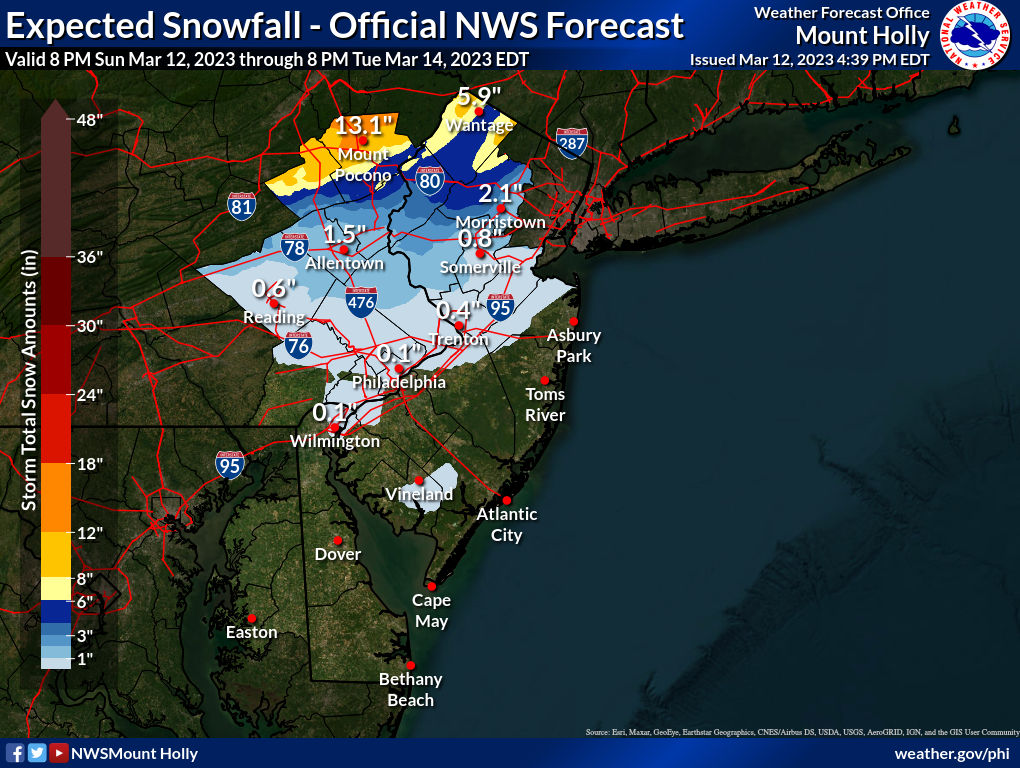
So, looking at the NWS snowfall map, above, and the actual snowfall map, below, I'd say the NWS did great for far northern aeas, like the Poconos, Sussex and northern Warren/Passaic/Morris (essentially N of 80), but busted moderately from there down to 78 and completely busted south of 78. At least they didn't go for the 1-3" of snow in CNJ/NYC that half the models were showing early this morning. So a mixed grade...

UroqRZr.jpg
 
The Mon/Tues storm is still on the table with the 12Z NAM and GFS showing a decent snowstorm for most of us and a major snowstorm for areas N of 80, while the CMC/UK show a lot less precip/snow for our area as the storm is more to the east, crushing areas N of 84 and New England; The Euro is in-between these camps. Crazy to have this much disagreement less than 3 days out, but it reflects how exquisitely sensitive this setup is.

At this point some WAGs are as follows (big grain of salt here): about a 25% chance of significant snow for CNJ/EPA south of 78 and maybe a 50% chance for significant snow (roughly at least 3-4") for areas along/N of 78 up to 80 (includes Union-Hudson-Essex and NYC) and maybe 90% probability of significant snow along/N of 80 and N/NE of NYC and close to 100% for areas N of 84 from Eastern NYS through most of New England (where a major snowstorm of 8" or more is looking very likely and an historic storm , i.e, 16" or more, is possible.

edit...of course a lot of rain is possible too, such that it's quite possible for most in NJ/EPA, even up to 80, to get mostly rain, with 1-2" possible and even up to 3" seen on some models (which shows how much snow is theoretically possible for areas, like N of 84 that stay mostly/all snow, i.e, 1-2 feet or more) followed by a bit of snow and maybe no snow at all south of 78. And high winds are likely for many and coastal flooding is possible too, as this is likely to be a very powerful storm...

https://www.americanwx.com/bb/topic/58993-march-13-14th-noreaster-threat/page/21/

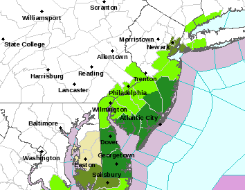
Summary: With regard to forecasts, the NWS is taking a conservative view as usual, but the NWS in Mt. Holly upped their snowfall totals at 4 am relative to 4 pm yesterday, to respond to increases in modeled snowfall, but you can see that the NWS-Upton did not, given the discontinuities at the county interfaces (from 1-2" in Morris/Somerset/Middlesex to <1" across the magical border into Essex/Union/SI (see both maps below and the map from DT/WxRisk, which is a little more aggressive, but looks reasonable to me). Also, note that this means that much of the 1-2" of precip that will fall from Monday afternoon through Tuesday morning will be in the form of rain for anyone south of about I-80 (much more snow N of 80 and less rain, but mostly rain south of 78 with some snow by Tuesday morning). This could lead to urban/stream flooding, plus there is a good chance of high winds (especially at the coast) and minor coastal flooding, as this will be a powerful storm.

The NWS has issued winter storm watches for 4-9" of snow for the Poconos, Sussex, NW Passaic, and Orange/Putnam - and everywhere N of 84 in NY and New England (away from the coast) is under watches for even more snowfall than that, i.e., 8-18". And the NWS did say they would likely need advisories for 2-4" for counties along/N of 78, so at least the Lehigh Valley through Warren/Morris and probably Essex/Bergen (and maybe Upper Bucks-Hunterdon-Somerset).

Some Details: Well, the 0Z models last night almost all trended towards significantly snowier solutions and that was just 36-42 hours from the start of the festivities on Monday afternoon, but then 1-2 models took a step back at 6Z (which just came out), but 1 went snowier. We're at a point where the models ought to be converging on some sort of consensus solution...but they're not yet, given how extraordinarily complex and sensitive this setup is to minor perturbations, so stay tuned as the only thing I'm certain of is that there will still be substantial changes from now until the storm starts.

Specifically, the complexity comes from trying to figure out which model is capturing best the progression of a low moving across the SE US and then blossoming into a powerful low off the NC coast and moving up towards us, anywhere from south of LI to east of Cape Cod. In addition, the upper level low energy approaching from the Ohio Valley, is expected to "phase" to some or full extent with that surface coastal low and how much phasing occurs and where it occurs leads to tremendous variability in precip rates and thermal profiles in the column from the ground up to over 10K feet where the snow is being generated (some of which melts into rain on the way down, depending on where one is).

To reflect the wide range of outcomes of the models, without posting them, which would likely be a waste of time, the range of snowfall predicted for New Brunswick is from 0-8" across the models, with most in the 1-4" range and the range of snowfall predicted for NYC is from 0-12" across the models. Similarly, the ranges for areas like Sussex and the Poconos are from 4-18". Crazy - and it makes it very hard to provide accurate forecasts this far out.

Also, keep in mind that some of the snowfall shown on the models is relatively light snowfall accumulating after 12Z (which is now 8 am with DST) on Tuesday with temps at or above 32F in mid-March in NYC/LI/CNJ and that's likely going to be cut down significantly, although not completely, since that snow will be falling on 32F snow already on the ground, not 34-35F bare ground (except paved surfaces that are cleared/treated). So, my guess is the Kuchera maps are a decent guesstimate for snow ratios for that timeframe (probably 6-8" snow per 1" liquid equivalent) and 10:1 probably is good ratio to use before 8 am with heavier rates and before the sun is up too high; unfortunately using either 10:1 or Kuchera for the whole storm is probably inaccurate. In any case, if you like snow you want as much of the snow to fall before 8-9 am on Tuesday as possible.

https://www.weather.gov/phi/
https://www.americanwx.com/bb/topic/58993-march-13-14th-noreaster-threat/page/28/

AWSRLSY.png


is7BVRF.png


vfa3u2U.png
 
So south of Route 78, little or no snow, mainly rain, correct?
Some snow probably: 1-2" from NWS/2-4" from DT and models show 0-8" lol, so there's still potential for more than 1-2". 0" and all rain is still on the table too. Does that help? lol, it's just too early to know...
 
This is not a forecast - it's just one model run, but it's a doozy...

We've officially been NAM-ed, as the 12Z NAM which just came out shows the potential of this highly complex, very powerful nor'easter. This snowfall map is crazy and the snow falls after almost everyone gets an inch of rain on Monday (the transition to snow is by about 1-3 am Tuesday for most and is over by late Tuesday night). This kind of possibility is why I've been following this so closely. We could still mostly whiff and get mostly rain for CNJ/NENJ/NYC and even much of NNJ/EPA, but this model run shows what is possible in this kind of explosive setup. Also, we're not 5 days out, we're 24-30 hours from the start of the event late Monday morning. Reminds me of the NAM for Jan 2016's blizzard, where it was the first model to sniff out the huge potential (about 48 hrs before the event, iirc). Stay tuned folks.

XaVI70y.png


xEQ4c91.png


Edit: And the 12Z RGEM (similar to the NAM in that it's another mesoscale, high resolution model, but based off the Canadian CMC model core) just came out and showed by the NAM could be completely out to lunch. As I was saying last night, all of the models show the potential for 10-18"+ snow for NY/New England (and even N of 80), but the huge variability has been for areas between 195 and 80, which is only about 50 miles. Need to see the rest of the 12Z model suite to get an idea of how likely either model is to verify...

W7KJaUi.png
 
Last edited:
  • Haha
Reactions: rurichdog
This is not a forecast - it's just one model run, but it's a doozy...

We've officially been NAM-ed, as the 12Z NAM which just came out shows the potential of this highly complex, very powerful nor'easter. This snowfall map is crazy and the snow falls after almost everyone gets an inch of rain on Monday (the transition to snow is by about 1-3 am Tuesday for most and is over by late Tuesday night). This kind of possibility is why I've been following this so closely. We could still mostly whiff and get mostly rain for CNJ/NENJ/NYC and even much of NNJ/EPA, but this model run shows what is possible in this kind of explosive setup. Also, we're not 5 days out, we're 24-30 hours from the start of the event late Monday morning. Reminds me of the NAM for Jan 2016's blizzard, where it was the first model to sniff out the huge potential (about 48 hrs before the event, iirc). Stay tuned folks.

XaVI70y.png


xEQ4c91.png
Your personal wishcast is going to bust again! :)
 
  • Like
Reactions: bac2therac
Nam has a band just sitting over NYC/NJ…hence the large numbers in NE NJ and NYC.
 
and the Canadian model just came out and gave most of NJ south or route 80…basically no snow. Very tricky forecast lol
 
Prepare for the worst, hope for the best. This is feeling like a now cast storm.
 
GFS also shows very little if any snow about south of I-80.

The NAM is the outlier right now and shouldn’t be taken seriously by any reputable met
 
  • Like
Reactions: Joey Bags
Summary: With regard to forecasts, the NWS is taking a conservative view as usual, but the NWS in Mt. Holly upped their snowfall totals at 4 am relative to 4 pm yesterday, to respond to increases in modeled snowfall, but you can see that the NWS-Upton did not, given the discontinuities at the county interfaces (from 1-2" in Morris/Somerset/Middlesex to <1" across the magical border into Essex/Union/SI (see both maps below and the map from DT/WxRisk, which is a little more aggressive, but looks reasonable to me). Also, note that this means that much of the 1-2" of precip that will fall from Monday afternoon through Tuesday morning will be in the form of rain for anyone south of about I-80 (much more snow N of 80 and less rain, but mostly rain south of 78 with some snow by Tuesday morning). This could lead to urban/stream flooding, plus there is a good chance of high winds (especially at the coast) and minor coastal flooding, as this will be a powerful storm.

The NWS has issued winter storm watches for 4-9" of snow for the Poconos, Sussex, NW Passaic, and Orange/Putnam - and everywhere N of 84 in NY and New England (away from the coast) is under watches for even more snowfall than that, i.e., 8-18". And the NWS did say they would likely need advisories for 2-4" for counties along/N of 78, so at least the Lehigh Valley through Warren/Morris and probably Essex/Bergen (and maybe Upper Bucks-Hunterdon-Somerset).

Some Details: Well, the 0Z models last night almost all trended towards significantly snowier solutions and that was just 36-42 hours from the start of the festivities on Monday afternoon, but then 1-2 models took a step back at 6Z (which just came out), but 1 went snowier. We're at a point where the models ought to be converging on some sort of consensus solution...but they're not yet, given how extraordinarily complex and sensitive this setup is to minor perturbations, so stay tuned as the only thing I'm certain of is that there will still be substantial changes from now until the storm starts.

Specifically, the complexity comes from trying to figure out which model is capturing best the progression of a low moving across the SE US and then blossoming into a powerful low off the NC coast and moving up towards us, anywhere from south of LI to east of Cape Cod. In addition, the upper level low energy approaching from the Ohio Valley, is expected to "phase" to some or full extent with that surface coastal low and how much phasing occurs and where it occurs leads to tremendous variability in precip rates and thermal profiles in the column from the ground up to over 10K feet where the snow is being generated (some of which melts into rain on the way down, depending on where one is).

To reflect the wide range of outcomes of the models, without posting them, which would likely be a waste of time, the range of snowfall predicted for New Brunswick is from 0-8" across the models, with most in the 1-4" range and the range of snowfall predicted for NYC is from 0-12" across the models. Similarly, the ranges for areas like Sussex and the Poconos are from 4-18". Crazy - and it makes it very hard to provide accurate forecasts this far out.

Also, keep in mind that some of the snowfall shown on the models is relatively light snowfall accumulating after 12Z (which is now 8 am with DST) on Tuesday with temps at or above 32F in mid-March in NYC/LI/CNJ and that's likely going to be cut down significantly, although not completely, since that snow will be falling on 32F snow already on the ground, not 34-35F bare ground (except paved surfaces that are cleared/treated). So, my guess is the Kuchera maps are a decent guesstimate for snow ratios for that timeframe (probably 6-8" snow per 1" liquid equivalent) and 10:1 probably is good ratio to use before 8 am with heavier rates and before the sun is up too high; unfortunately using either 10:1 or Kuchera for the whole storm is probably inaccurate. In any case, if you like snow you want as much of the snow to fall before 8-9 am on Tuesday as possible.

https://www.weather.gov/phi/
https://www.americanwx.com/bb/topic/58993-march-13-14th-noreaster-threat/page/28/
AWSRLSY.png


is7BVRF.png


vfa3u2U.png
NWS has this for Belmar-Farmingdale (Updated this morning). @e5fdny , @knightfan7 and @koleszar - I ain't even gonna put the snowblower in the ready position.

Monday
Rain. High near 45. East wind 10 to 15 mph. Chance of precipitation is 100%. New precipitation amounts between a quarter and half of an inch possible.
Monday Night
Rain. Low around 36. East wind around 15 mph becoming northwest after midnight. Chance of precipitation is 90%. New precipitation amounts between a half and three quarters of an inch possible.
Tuesday
Rain and snow likely, mainly before 2pm. Mostly cloudy, with a high near 40. Windy, with a west wind 20 to 30 mph, with gusts as high as 40 mph. Chance of precipitation is 60%. New snow accumulation of less than one inch possible.
Tuesday Night
A chance of rain and snow before 9pm, then a chance of snow between 9pm and 2am. Mostly cloudy, with a low around 32. Windy. Chance of precipitation is 30%. New precipitation amounts of less than a tenth of an inch possible.


At least my brand spanking new snowblower won't get all dusty sitting in the box. Although I might take it out so I have a unique coat and hat hanger. That would go perfect with the shop decor.
 
GFS also shows very little if any snow about south of I-80.

The NAM is the outlier right now and shouldn’t be taken seriously by any reputable met
The NAM is only an outlier at the surface - the other models have moved significantly towards the NAM's mid/upper atmosphere level representation and those levels are what drives things at the surface. Sometimes it takes some time to resolve such differences, but the NAM is not an outlier. If you posted that on a weather forum, you'd be scolded/laughed at. Doesn't mean the NAM is going to be right, but it does mean there's a good possibility it is on to something.
 
Well, the 12Z NAM is certainly an outlier at the surface now with the UK and CMC having similar upper level profiles but different surface precip fields, while the GFS is definitely different aloft and at the surface. The bigger news is that the 12Z Euro just made a large shift at the surface and aloft towards the GFS, which has caused mass depression on the weather boards, as it is now in the camp of only giving CNJ/NYC/LI/NENJ a few inches of snow after only maybe an inch of rain Monday into early Tuesday - and the worst part is that the snowfall is mostly on Tuesday during the day, where most likely won't accumulate, as rates won't be high enough (the NAM rates were more than high enough to accumulate in mid-March at midday).

At this point, I would think the NAM is being discounted, although the RAP and HRRR, at long range, do show pretty hefty snowfalls for 95/NYC, but they're likely not going to be taken too seriously right now (out of their best range); also, we're still about 40 hours from when the snow would be starting if we get significant snow from this (after 1 am Tuesday), so there is still time for changes, but a major snowfall is now looking less likely for Trenton to NYC and SE of there and even along 78, with maybe a few inches falling. Areas along/N of 80 are still likely in for a plowable snow (4-8" perhaps) and areas along/N of 84 look to still be gettting 8-18" (eastern NY and interior New England).

Here's an interesting comment from a good pro on-line (33andrain went to a Discord server so one would have to sign up to see anything there), noting that the global models are in the east/less precip-snow camp and the high resolution mesoscale models are further west and could be on to something if the globals are "chasing convection" meaning the threat for heavier snow isn't over even if it looks kind of bleak right now : "Looking at the ECMWF over the past 4 runs, the surface low has definitely shifted SE, but the 500mb evolution has improved. I still think a lot of this is related to thunderstorm activity, which on the latest ECMWF really pulls the low east. We're now in a position where while the global models are generally east, and the high-resolution models are west. Given that the high-resolution models are higher resolution and can therefore resolve convection more accurately, I think I'd lean a little more west than east right now, but frankly the uncertainty is absurd for this lead time."

Might need to phone a friend, lol, as upper level patterns and phasing systems are not my area of expertise. Calling @RUJohnny...
 
Last edited:
The NAM is only an outlier at the surface - the other models have moved significantly towards the NAM's mid/upper atmosphere level representation and those levels are what drives things at the surface. Sometimes it takes some time to resolve such differences, but the NAM is not an outlier. If you posted that on a weather forum, you'd be scolded/laughed at. Doesn't mean the NAM is going to be right, but it does mean there's a good possibility it is on to something.

NAM has these outlandish runs all the time. Unless it consistently shows these totals 2 or even 3 times straight….no one should take it seriously.
 
I just checked weather.com for me and it's said 5-8" so a pretty decent amount.
 
All of these snow threads have failed in bring anything to most of us
It's been that kind of winter, although all of the snow threads, so far, were clearly advertised as no big deal for anyone south of 78 and often 80, so it's not like they were that far off. This is the first one that has looked like a possible big deal and while it's not looking like that right now, it still could be.
 
NAM has these outlandish runs all the time. Unless it consistently shows these totals 2 or even 3 times straight….no one should take it seriously.
It doesn't have them anywhere near all the time. It has them every year or two, but almost always much further out. It's pretty rare the NAM goes crazy this close to an event starting - but because it was clearly possible, that's why I tried to convey (in bold) that it was not a forecast and it could be completely wrong. Will be really interesting to see what the 18Z NAM shows in about 90 minutes...
 
The 1000mb easterly jet will be stronger than models think as per almost all events this year and will keep snow totals down to virtually nil south of 80 and only minor to moderate accumulations (4-6) in higher elevations of Sussex and Warren. Does not help that SSTs off the coast are warmer than normal for that easterly fetch.

Unfortunately a deepening storm will actually increase this jet until the low is well northeast of NJ, preventing the column from cooling all the way to the surface. 850s scream snowstorm, 1000mb says you will get nothing and like it, maybe some sleet mixed it.

La Nina plus a very strong mid-atl subtropical ridge has been the death knell for models this year. They struggle with each independently, put them together and they pump out mumbo jumbo.
 
Last edited:
The 1000mb easterly jet will be stronger than models think as per almost all events this year and will keep snow totals down to virtually nil south of 80 and only minor to moderate accumulations (4-6) in higher elevations of Sussex and Warren. Does not help that SSTs off the coast are warmer than normal for that easterly fetch.

Unfortunately a deepening storm will actually increase this jet until the low is well northeast of NJ, preventing the column from cooling all the way to the surface. 850s scream snowstorm, 1000mb says you will get nothing and like it, maybe some sleet mixed it.

La Nina plus a very strong mid-atl subtropical ridge has been the death knell for models this year. They struggle with each independently, put them together and they pump out mumbo jumbo.
I like this post more than others in this thread.
 
  • Like
Reactions: knightfan7
Summary: With regard to forecasts, the NWS is taking a conservative view as usual, but the NWS in Mt. Holly upped their snowfall totals at 4 am relative to 4 pm yesterday, to respond to increases in modeled snowfall, but you can see that the NWS-Upton did not, given the discontinuities at the county interfaces (from 1-2" in Morris/Somerset/Middlesex to <1" across the magical border into Essex/Union/SI (see both maps below and the map from DT/WxRisk, which is a little more aggressive, but looks reasonable to me). Also, note that this means that much of the 1-2" of precip that will fall from Monday afternoon through Tuesday morning will be in the form of rain for anyone south of about I-80 (much more snow N of 80 and less rain, but mostly rain south of 78 with some snow by Tuesday morning). This could lead to urban/stream flooding, plus there is a good chance of high winds (especially at the coast) and minor coastal flooding, as this will be a powerful storm.

The NWS has issued winter storm watches for 4-9" of snow for the Poconos, Sussex, NW Passaic, and Orange/Putnam - and everywhere N of 84 in NY and New England (away from the coast) is under watches for even more snowfall than that, i.e., 8-18". And the NWS did say they would likely need advisories for 2-4" for counties along/N of 78, so at least the Lehigh Valley through Warren/Morris and probably Essex/Bergen (and maybe Upper Bucks-Hunterdon-Somerset).

Some Details: Well, the 0Z models last night almost all trended towards significantly snowier solutions and that was just 36-42 hours from the start of the festivities on Monday afternoon, but then 1-2 models took a step back at 6Z (which just came out), but 1 went snowier. We're at a point where the models ought to be converging on some sort of consensus solution...but they're not yet, given how extraordinarily complex and sensitive this setup is to minor perturbations, so stay tuned as the only thing I'm certain of is that there will still be substantial changes from now until the storm starts.

Specifically, the complexity comes from trying to figure out which model is capturing best the progression of a low moving across the SE US and then blossoming into a powerful low off the NC coast and moving up towards us, anywhere from south of LI to east of Cape Cod. In addition, the upper level low energy approaching from the Ohio Valley, is expected to "phase" to some or full extent with that surface coastal low and how much phasing occurs and where it occurs leads to tremendous variability in precip rates and thermal profiles in the column from the ground up to over 10K feet where the snow is being generated (some of which melts into rain on the way down, depending on where one is).

To reflect the wide range of outcomes of the models, without posting them, which would likely be a waste of time, the range of snowfall predicted for New Brunswick is from 0-8" across the models, with most in the 1-4" range and the range of snowfall predicted for NYC is from 0-12" across the models. Similarly, the ranges for areas like Sussex and the Poconos are from 4-18". Crazy - and it makes it very hard to provide accurate forecasts this far out.

Also, keep in mind that some of the snowfall shown on the models is relatively light snowfall accumulating after 12Z (which is now 8 am with DST) on Tuesday with temps at or above 32F in mid-March in NYC/LI/CNJ and that's likely going to be cut down significantly, although not completely, since that snow will be falling on 32F snow already on the ground, not 34-35F bare ground (except paved surfaces that are cleared/treated). So, my guess is the Kuchera maps are a decent guesstimate for snow ratios for that timeframe (probably 6-8" snow per 1" liquid equivalent) and 10:1 probably is good ratio to use before 8 am with heavier rates and before the sun is up too high; unfortunately using either 10:1 or Kuchera for the whole storm is probably inaccurate. In any case, if you like snow you want as much of the snow to fall before 8-9 am on Tuesday as possible.

https://www.weather.gov/phi/
https://www.americanwx.com/bb/topic/58993-march-13-14th-noreaster-threat/page/28/

AWSRLSY.png


is7BVRF.png


vfa3u2U.png

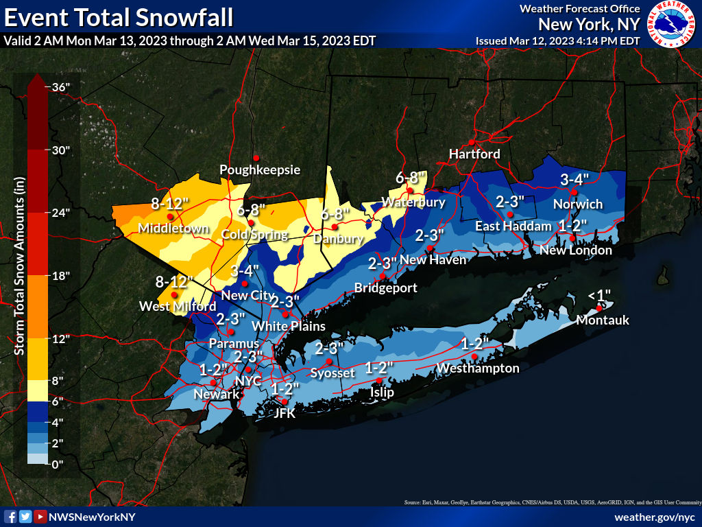
Got stuff to do, so this will be brief. NWS-Philly kept all of the same watches, but increased snowfall amounts in the watch areas (Carbon/Monroe - Poconos - and Sussex) to 6-12", while the NWS-NYC kept the watches for NW Passaic, Orange/Putnam, but increased amounts to 6-10", plus they expanded the watches to include all of SE Passaic, NW Bergen and Rockland/N Westchester for 4-7" of snow. No advisories are up yet, since we're still 30+ hours away from any change to snow (plus I think the offices are simply praying we'll have more clarity on the storm by then with tonight's 0Z models, since the models are still all over the place. I don't envy the NWS here.

I expect we'll see the watches converted to warnings and a bunch of advisories issued with the 4 am package for maybe 2-4/3-6" amounts for the next tier of counties, like the Lehigh Valley, Warren/Morris and SE Bergen/Essex and southern Westchester. not sure if we'll also see advisories for Hunterdon/Somerset (probably) and Union, Hudson and NYC/LI (maybe). Also, updated maps are below and as often happens, we have a discontinuity between offices, as snowfall forecasts by the NWS-NYC are for 1-2" for Essex/Union/SI, but neighboring Morris/Somerset/Middlesex all have <1" forecast by the NWS-Philly. For almost everyone, there will be rain throughout tomorrow (up to 1/2" by evening) with the expected changeover to snow starting in the far NW areas and moving SE overnight, such that the heaviest snow to the N/NW would be from maybe 1-2 am to early afternoon Tuesday and maybe just after sunrise for places that don't get much snow - and some of the snow that falls during the day will melt, making accumulations tough without high rates.

The 18Z suite of models just started coming out and the NAM-12km backed off hugely from the bomb it showed 6 hours ago with only a few inches of snow for CNJ/NYC/S of 78 (a lot more north of there still), while the 3km NAM (which is better with convection and some think convection is screwing up the models) shows 6-12" for most of CNJ/NYC and a lot more N of there. This is essentially the same friggin' model with the 3km NAM having higher resolution (tighter grid spacing) and a different way of analyzing convection and that seems like it was enough to have them with totally different outcomes, which is very rare. My guess is we don't have consensus even tonight, the way this is going. So if this blows up and becomes a big snowstorm, most won't be prepared, plus absolutely no snow along/S of 78 and all rain is still a viable solution. The only good thing about the models showing an easterly low track with less snow is that they also have a lot less precip (maybe only 1-1.5" vs. up to 3"), so flooding would be a lot less likely. High winds and minor coastal flooding is also likely regardless of the snow/rain debate.

https://www.weather.gov/phi/

GK1uPI7.png


vfLrnFq.png
 
ADVERTISEMENT
ADVERTISEMENT