Same here in Manasquan. Big flakes.Get yer mittens on! Light snow in Robbinsville. No accumulation.
The kind of snow I like.
Could do without the winds coming along with the flakes.
Same here in Manasquan. Big flakes.Get yer mittens on! Light snow in Robbinsville. No accumulation.
Go Canucks! I grew up in NP's West End.Snowing pretty good for a bit in No. Plfd. but nothing sticking. Now it's just flurries. The wind may be the bigger problem when the system pulls away.
After about 4 hours of light to moderate snow at 33-34F, with a few light dustings established and then melted quickly as intensity lessened, just now we're finally getting sustained moderate snow (maybe 3/8 of a mile visibility (maybe 600-700 yards) at 32F and we now officially have a "full dusting" or "light coating" (whatever that is, lol) on the colder surfaces (and a good 1/4" on trees, but that doesn't count, lol) which translates to about 0.1".Just woke up from a decent nap as it was just pixie dust for a few hours since about 7 am and it's been light to almost moderate but no accumulation at 34F...and then the last 10-15 minutes has been moderate snow and we now officially have a very light dusting. Time to fire up the generator!
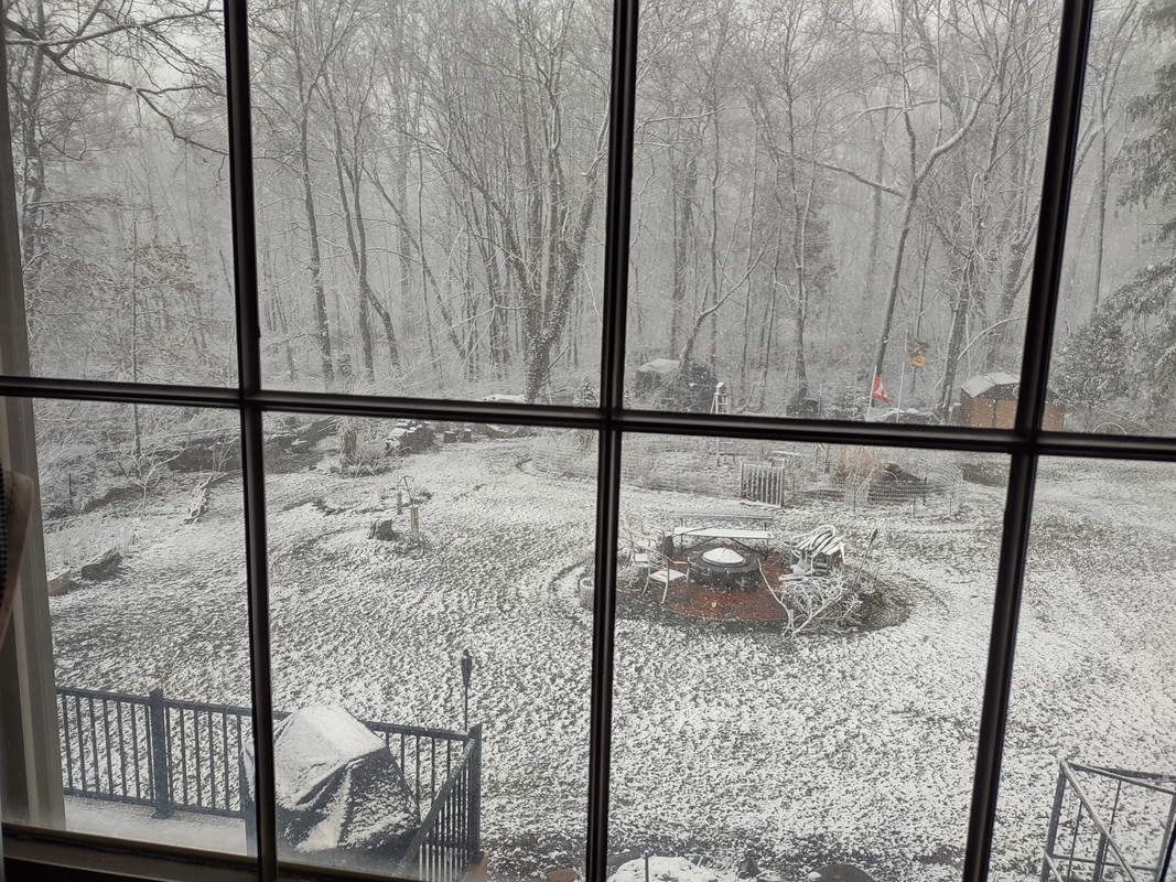
You should be getting into the heavier stuff now and the sun is lower - should get some accumulation now. It's really pretty on the trees and no worries about it on pavement...Nothing has or is sticking in Belle mead
You should be getting into the heavier stuff now and the sun is lower - should get some accumulation now. It's really pretty on the trees and no worries about it on pavement...
It has literally been "snowing" for 6 hours and nothing even on the grass! LOL.Nothing has or is sticking in Belle mead
How are the whales?Same here in Manasquan. Big flakes.
The kind of snow I like.
Could do without the winds coming along with the flakes.
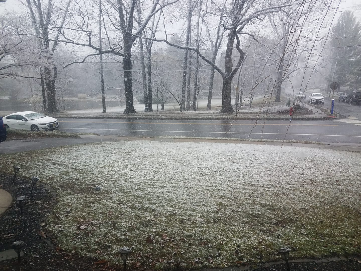
95%. 🤣Theres a bit on grass but good lord not worth mentioning
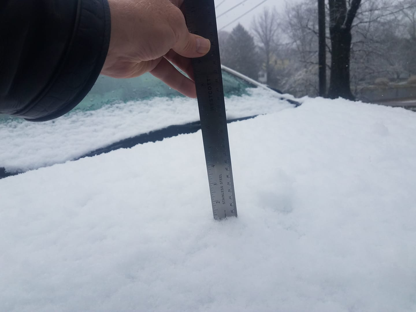
How did you get that much on your car with this? You must have a mini snow-making machine over there, there's no other way! 😂We're up to 1/2" on the board on the lawn and the trees have about 1/2", while my undisturbed car in the shade has almost 1" on it and nada on pavement. I'm recording 1/2" right now, since the car is definitely an outlier - I've almost never seen this kind of difference before and I'm sure it's due to the car top being just slightly colder than the ground/board. Still 32F and coming down moderately, so we could get to 1" if that band stays over us (we'll be right on the eastern edge of it). Most years I wouldn't care much about every 1/4" but this winter is different.
Edit: here's the pic of 1" on the car. So odd. Still at 1/2" on the board, as intensity has let up a little. About to head out to the OB and then the game...
I got it for you. As a fellow Rutgers fan I give 50% off. You only owe me $50.I'm out of the country this week, do I need to send someone to shovel my sidewalk?. In Cranford, obviously.
Metuchen polar vortex.How did you get that much on your car with this? You must have a mini snow-making machine over there, there's no other way! 😂
Blubbering about the weatherHow are the whales?
I had about 0.6" on the board and most of the grass when I left around 5:15 pm to go to the RU game and got back around 9:30 pm and checked the board, which I had wiped before I left, and had another 0.4" on it, so I'm calling it an even 1.0". The car had about 1.2" when I got back, probably due to compaction. The amounts on lawns varied widely in town, depending, I think, on shade level given the strong indirect sunlight in mid-March - my backyard was half covered and the front yard was nearly completely covered (it's shadier). Also, I was monitoring the radar after I left and it looks like Metuchen stayed pretty well under that band for a few hours after I left (my wife confirmed), so an additional 0.4" with snow falling mostly after the sun was low/down, seems reasonable, as does the 1.0" total measurement, especially given a report of 1.4" from neighboring Edison. That brings my total to 5.1" for the season vs. a long-term average of about 29" per season.We're up to 1/2" on the board on the lawn and the trees have about 1/2", while my undisturbed car in the shade has almost 1" on it and nada on pavement. I'm recording 1/2" right now, since the car is definitely an outlier - I've almost never seen this kind of difference before and I'm sure it's due to the car top being just slightly colder than the ground/board. Still 32F and coming down moderately, so we could get to 1" if that band stays over us (we'll be right on the eastern edge of it). Most years I wouldn't care much about every 1/4" but this winter is different.
Edit: here's the pic of 1" on the car. So odd. Still at 1/2" on the board, as intensity has let up a little. About to head out to the OB and then the game...
No idea - most of the cars in the neighborhood looked like that. I guess the cartops were just slightly colder and it made a big difference in accumulation vs. on the grass, as you can see from the pictures I posted. Definitely unusual, although if I had a snowmaking machine it would've been worthless with temps above 32F all day. There is this guy in Midlothian, VA (near Richmond), who has a snowmaking machine and every year he fires it up when it's cold so he has snow on his lawn. Always cracked me up, as he has a bit of a hill and neighborhood kids come there to sled.How did you get that much on your car with this? You must have a mini snow-making machine over there, there's no other way! 😂
Lol. Nothingburger thread!It has literally been "snowing" for 6 hours and nothing even on the grass! LOL.
That's what she said. To you. When she saw it. 😉Nothingburger thread!
No snow stuck to my upper deck, but some did stick to my lower deck for some reason. Also, my neighbor's deck, which is a little higher than my upper deck, had a lot stick to it. I guess it had more to do with the effect of wind than anything else.No idea - most of the cars in the neighborhood looked like that. I guess the cartops were just slightly colder and it made a big difference in accumulation vs. on the grass, as you can see from the pictures I posted. Definitely unusual, although if I had a snowmaking machine it would've been worthless with temps above 32F all day. There is this guy in Midlothian, VA (near Richmond), who has a snowmaking machine and every year he fires it up when it's cold so he has snow on his lawn. Always cracked me up, as he has a bit of a hill and neighborhood kids come there to sled.
Don't put that winter coat away just yet bucko. i'm seeing lows in the upper 20's - low 30's Sat - Tue.No matter how cold it's been for nearly a week, the sun is out today and can see tons of stuff blooming on my way home. Winter is over!
It's might just be recency bias on my part, but it sure seems like we have a lot more days with high gusty winds than we used to have a 5 to 10 years or more ago. Always had windy days now and then. But nothing like it's been the past few years.Yet again the most notable part is this damn wind. 50.8 MPH gust a mile from here.
I expect overnight lows to be cold but only one daytime high stays in the 40s .... possibly the rest of the month.Don't put that winter coat away just yet bucko. i'm seeing lows in the upper 20's - low 30's Sat - Tue.
Just like MY old saying goes...March comes in like lion and goes out like a.....lion.
Fascinating snowfall map - as often happens in mid-March with warmer temps and longer days, snowfall amounts varied hugely over small distances, especially with elevation. You can see this in NJ in Sussex/Morris/NW Passaic (note: the issue for Warren and the Lehigh Valley wasn't elevation, it was lack of precip that far SW) and also in SENY, CT, MA, from SE to NW. If this snow had happened at night or on a colder day, we would've had 3-5" of snow throughout most of NJ along and SE of 95 to the coast and elsewhere. Can see how hard it would be to try to forecast this storm.I had about 0.6" on the board and most of the grass when I left around 5:15 pm to go to the RU game and got back around 9:30 pm and checked the board, which I had wiped before I left, and had another 0.4" on it, so I'm calling it an even 1.0". The car had about 1.2" when I got back, probably due to compaction. The amounts on lawns varied widely in town, depending, I think, on shade level given the strong indirect sunlight in mid-March - my backyard was half covered and the front yard was nearly completely covered (it's shadier). Also, I was monitoring the radar after I left and it looks like Metuchen stayed pretty well under that band for a few hours after I left (my wife confirmed), so an additional 0.4" with snow falling mostly after the sun was low/down, seems reasonable, as does the 1.0" total measurement, especially given a report of 1.4" from neighboring Edison. That brings my total to 5.1" for the season vs. a long-term average of about 29" per season.
With regard to other locations, I think the last forecast from the NWS, this morning, ended up verifying pretty well (although the forecast from last night was still pretty high and the one from yesterday morning was way high). Reports of 4-9" in Sussex, 3-6" in Morris, 2-3" in northern Somerset and northern Hunterdon, up by 78, 2-3" in Bergen, 3-5" in NW Passaic, 3-7" in the Poconos and generally 5-10" N of 84 in NEPA, SENY and CT with some 18-36" amounts in the mountains from the Catskills to the Adirondacks to New England. Even Freehold surprisingly reported 1". But also, lots of places south of 78 and even N of 78 in NENJ/NYC reporting <1" or even nada, as the bands that came through and lasted were not hitting everywhere equally at all. Will post a map when all the reports are in and scrubbed (reports before noon are meaningless with more snow that fell after).
https://www.weather.gov/wrh/TextProduct?product=pnsphi
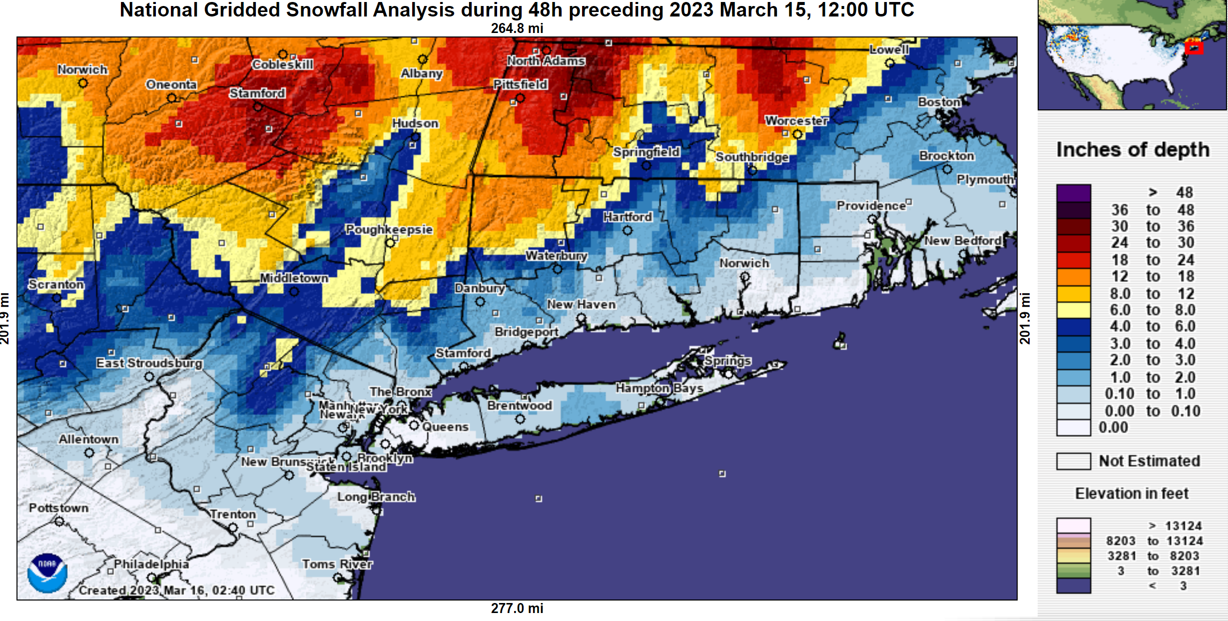
Saugerties is the low elevation (~500 ft) location that got 0.1", while Palenville, 3.7 miles away, is over 3000' and got 36". Just crazy.Not sure I believe this but crazy if true. 3.69 miles separates 36" of snow. Is Saugerties elevation that much highr?
Moist adiabatic lapse rate: 3.3 degrees Fahrenheit per 1000 feet elevation change. Approximately. So all things being equal, it could easily be 33 and raining in Saugerties, while 23 and puking snow in Palenville 3.7 miles horizontal distance, 3000 feet elevation away.Saugerties is the low elevation (~500 ft) location that got 0.1", while Palenville, 3.7 miles away, is over 3000' and got 36". Just crazy.
Not sure I believe this but crazy if true. 3.69 miles separates 36" of snow. Is Saugerties elevation that much highr?
Saugerties is the low elevation (~500 ft) location that got 0.1", while Palenville, 3.7 miles away, is over 3000' and got 36". Just crazy.
Moist adiabatic lapse rate: 3.3 degrees Fahrenheit per 1000 feet elevation change. Approximately. So all things being equal, it could easily be 33 and raining in Saugerties, while 23 and puking snow in Palenville 3.7 miles horizontal distance, 3000 feet elevation away.
I just find that kind of shit seriously cool.